Attached files
Exhibit 10.1
EXECUTION VERSION
PURCHASE AND SALE AGREEMENT
This Purchase and Sale Agreement (this “Agreement”) is entered into this 19th day of October, 2015, by and among First States Investors 6000A, L.P. (“6000A Seller”), First States Investors 6000B, L.P. (“6000B Seller”), First States Investors 6000C, L.P. (“6000C Seller”) and First States Investors 6000D, L.P. (“6000D Seller”, and together with 6000A Seller, 6000B Seller and 6000C Seller, each, individually, and collectively “Seller”) and PONTUS NET LEASE ADVISORS, LLC, a Delaware limited liability company (“Purchaser”). In consideration of the mutual agreements herein set forth, the parties hereto, intending to be legally bound, agree as follows.
1. Defined Terms/Exhibits: Capitalized terms used in this Agreement shall, for purposes of this Agreement, have the meanings ascribed to such terms in this Section 1. Initial capitalized terms used in this Agreement and not defined in this Section 1 shall have the meanings ascribed to such terms elsewhere in this Agreement.
Additional Permitted Exceptions | The title exceptions listed on Exhibit J. |
Building | The building improvements located on the Land. |
Business Day | Each day of the week except Saturdays, Sundays and federal holidays. |
Contracts | The service contracts, maintenance agreements, or other agreements, and brokerage commission agreements affecting the Properties that will survive the Closing. |
Delinquent Rent | Means any of rent, additional rent or other amounts that, under the terms of the Leases, are to be paid by the Tenant for periods ending on or prior to the Closing Date, but which have not been received in good funds by Seller on or prior to the Closing Date. |
Deposit | $2,000,000.00, allocated among the Parcels as set forth on Exhibit H. |
Escrowee | First American Title Insurance Company 633 Third Avenue New York, NY 10017 Attention: Phillip Salomon Tel: (212) 551-9437 psalomon@firstam.com |
Exhibits | Exhibits A-1 – A-61 – Land Legal Description for each Parcel Exhibit B - Escrow Agreement Exhibit C-1 – C-61 – List of Leases for each Parcel |
Exhibit D-1 – Florida Form of Deed Exhibit D-2 – Georgia Form of Deed Exhibit D-3 – North Carolina Form of Deed Exhibit D-4 – South Carolina Form of Deed Exhibit D-5 – Arkansas Form of Deed Exhibit D-6 – California Form of Deed Exhibit D-7 – New Jersey Form of Deed Exhibit D-8 – Virginia Form of Deed Exhibit E-1 – List of Multi-Property Transfer Notice Tenants Exhibit E-2 – List of ROFO Tenants Exhibit F – Form of Tenant Estoppel Exhibit G – Form of Assignment of Leases Exhibit H – Allocation of Purchase Price and Deposit Among Parcels Exhibit I – Form of Title Affidavit Exhibits J – Additional Permitted Exceptions Exhibit K – List of Parcels by Address Exhibit L – Title Policy Responsibility Exhibit M – Form of Notice to Tenant(s) Exhibit N – List of Existing Loan Documents Exhibit O – Litigation and Condemnation Exhibit P-1 – Form of Multi-Property Transfer Notice Exhibit P-2 – Form of ROFO Notice | |
Existing Debt | Loans in the original principal amount of $110,394,000 evidenced by the Existing Loan Documents. |
Existing Loan Documents | The loan documents listed on Exhibit N. |
Existing Lender | Collectively, (i) Wells Fargo Bank, N.A. as Trustee for the Registered Holders of Banc of America Commercial Mortgage Inc, Commercial Mortgage Passthrough Certificates, Series 2008-LS1; and (ii) Wells Fargo Bank, N.A., as trustee for the registered holders of COMM Commercial Mortgage Trust 2007-C9, Commercial Mortgage Pass-Through Certificates, Series 2007-C9.Certificates, Series 2008-LS1; and (ii) Wells Fargo Bank, N.A., as trustee for the registered holders of COMM Commercial Mortgage Trust 2007-C9, Commercial Mortgage Pass-Through Certificates, Series 2007-C9. |
Fixtures | All equipment, fixtures and appliances of whatever nature which are (i) affixed to the Land or Improvements and (ii) owned by Seller. |
Improvements | The buildings, building pads, structures, improvements, and personal property erected or located on the Land, including, without limitation, the Building, all parking lots, walkways and other paved areas on the Land, any |
2
and all exterior shrubs, trees, plants and landscaping on the Land. | |
Land | The land more particularly described on Exhibits A-1 – A- 61 with respect to each Parcel. |
Leases | The leases described on Exhibits C-1 – C-61 with respect to the applicable Parcel. |
Parcels | Each of the parcels of Land described on Exhibit K. |
Person | Any individual, corporation, partnership, limited liability company, trust, unincorporated association, government, governmental authority, or other entity. |
Personal Property | The aggregate of the following: (i) Seller’s right, title and interest, if any, in any intangible property (including, without limitation, the Contracts, all licenses, plans, specifications, permits and warranties, guaranties, indemnities, and bonds), that (a) relate to any Property and (b) are assignable by Seller to Purchaser; (ii) Seller’s oil, gas, water, mineral rights and water rights, if any, that relate to any Property; (iii) all right, title and interest of Seller, if any, to any land lying in the bed of any street, alley or road (open or proposed) abutting any Property; and (iv) Seller’s damages, awards, claims and causes of action now or hereafter payable or assertable with respect to any Property by reason of any exercise of the power of eminent domain, any change in the grade of any street, road, highway, avenue or alley, or any damage, destruction, loss or removal of any of the foregoing, which (a) relate to any Property and (b) are assignable by Seller to Purchaser. |
Property | With respect to each Parcel, collectively, (i) the Land, (ii) the Improvements, (iii) the Fixtures, (iv) the Personal Property, (v) the tenements, hereditaments, appurtenances, rights of way, strips, gores, easements, rights and privileges in any way pertaining or beneficial to the Land or Improvements, including, without limitation, all easements, rights-of-way and other similar interests appertaining to the Land or the Improvements. |
Purchase Price | $145,000,000.00, allocated among the Properties as set forth on Exhibit H attached hereto. |
Purchaser's EIN | 45-5352197 |
3
Purchaser's Notice Address | c/o Pontus Capital 875 Prospect Street, Ste. 303 La Jolla, California 92037 Attention: Michael Press E-mail: mpress@pontuscapital.com With a required copy to: Seyfarth Shaw LLP 333 South Hope Street, Suite 3900 Los Angeles, California 90071 Attention: Dana Treister, Esq. E-mail: dtreister@seyfarth.com |
Rent | Shall mean fixed and minimum rents and all additional rents, escalation charges, maintenance charges, insurance charges, percentage rent, and all other amounts, charges and commissions payable by any Tenant under the Leases. |
Scheduled Closing Date | On or before 5:00 P.M. (EST) February 2, 2016. |
Seller's EIN | 6000A Seller: 20-8753875 6000B Seller: 20-8753929 6000C Seller: 20-8753992 6000D Seller: 20-8754042 |
Seller's Notice Addresses | c/o Gramercy Property Trust 521 Fifth Ave 30th Floor New York, New York 10175 Attention: Allan B. Rothschild E-mail: rothschild@gptreit.com With a required copy to: c/o KBS Capital Advisors LLC 620 Newport Center Drive Suite 1300 Newport Beach, California 92660 Attention: James Chiboucas, Esq. E-mail : jchiboucas@kbsrealty.com And to: c/o KBS Capital Advisors LLC |
4
620 Newport Center Drive Suite 1300 Newport Beach, California 92660 Attention: Jeff Waldvogel E-mail: jwaldvogel@kbs.com And with a required copy to: Greenberg Traurig, LLP 200 Park Avenue New York, New York 10166 Attention: Stephen L. Rabinowitz, Esq. E-mail: rabinowitzs@gtlaw.com | |
Transfer Tax | Any tax, levy, fee, charge or documentary stamp required to be paid or purchased in connection with the sales transaction contemplated hereunder or recordation of a deed. |
All Exhibits and other attachments hereto are incorporated herein by reference, and taken together with this Agreement, shall constitute a single agreement. All documents to be executed and delivered by Purchaser (and/or any of its affiliates) and/or Seller (and/or any of its affiliates) at or prior to the Closing as contemplated by this Agreement are collectively referred to herein as the “Transaction Documents.”
2. Sale-Purchase. For the Purchase Price and subject to the terms and conditions hereof, each Seller agrees to sell and convey to Purchaser, and Purchaser agrees to purchase and take from such Seller, all of such Seller’s right, title and interest in and to the Property owned by it.
3. Purchase Price. The Purchase Price for the Properties shall be payable by Purchaser as follows:
3.1 Deposit. The Deposit is payable by Purchaser to Escrowee by wire transfer of immediately available funds by not later than 5p.m. EST on a date which is within one (1) Business Day of the date of the full execution and delivery of this Agreement, to be held in escrow and disbursed by Escrowee pursuant to the provisions of that certain Escrow Agreement (the “Escrow Agreement”) of even date herewith among Seller, Purchaser and Escrowee, a copy of which is attached hereto as Exhibit B. Failure by Purchaser to timely pay the Deposit shall give Seller the immediate right to terminate this Agreement, without any notice or grace period. At Closing, the Deposit shall be credited to Purchaser on account of the Purchase Price. The Deposit shall be deposited by Escrowee in an interest-bearing account reasonably approved by Purchaser and Seller and all interest thereon shall be paid to the party who receives the Deposit and, at Closing, credited against the Purchase Price.
5
3.2 Cash Balance. Subject to adjustments and credits in accordance with Sections 3.3, 11 and 35 hereof and the other prorations and adjustments herein provided for, the balance of the Purchase Price (the “Cash Balance”), shall be payable by Purchaser at Closing by wire transfer in accordance with the provisions of this Agreement.
3.3 Defeasance of the Existing Debt.
3.3.1 Seller and Purchaser acknowledge and agree that Seller’s title to the Properties is encumbered by the Existing Debt, which is required to be defeased in connection with the sale of the Properties (the “Defeasance”). Seller will send notice of its intent to defease the Existing Debt to the Existing Lender not later than five (5) Business Days after the expiration of the Due Diligence Period. Seller and Purchaser shall use commercially reasonable efforts, and cooperate with one another in good faith, to satisfy the requirements of the Existing Loan Documents with respect to the Defeasance including, without limitation, by funding prior to the Closing Date amounts necessary to effect the Defeasance and delivering such documents as may be required to effect the Defeasance (the “Defeasance Documents”).
3.3.2 Purchaser and Seller agree that, in connection with the Defeasance of the Existing Debt, Seller shall be responsible for payment of all actual, out-of-pocket costs and expenses in connection with the Defeasance (such amount, less the amount of Purchaser’s and Seller’s attorneys’ fees, the “Defeasance Costs”). The parties estimate the Defeasance Costs to be $10,000,000.00 (the “Estimated Defeasance Expense”). The Defeasance Costs actually payable at Closing if the Closing occurs on the Scheduled Closing Date shall be referred to herein as the “Scheduled Defeasance Expense,” and the positive difference between the Estimated Defeasance Expense and the Scheduled Defeasance Expense shall be referred to herein as the “Purchaser Defeasance Credit.” In the event that the Closing occurs on the Scheduled Closing Date, Purchaser shall receive a credit at Closing equal to the Purchaser Defeasance Credit. In the event that Seller elects to extend the Scheduled Closing Date pursuant to Section 3.3.3, below, then Purchaser shall receive a credit at Closing equal to the Purchaser Defeasance Credit, plus any amount by which the Defeasance Costs actually payable at Closing (such amount, the “Actual Defeasance Expense”) are less than the Scheduled Defeasance Expense. In the event that Purchaser elects to extend the Scheduled Closing Date pursuant to Section 4.1, below, and the Actual Defeasance Expense exceeds the Scheduled Defeasance Expense, then Purchaser shall receive a credit at Closing equal to the Purchaser Defeasance Credit, less any amount by which the Actual Defeasance Expense exceeds the Scheduled Defeasance Expense; provided that if the Actual Defeasance Expense exceeds the Estimated Defeasance Expense, Purchaser shall pay the amount of such difference. In the event that Purchaser elects to extend the Scheduled Closing Date pursuant to Section 4.1, below, and the Actual Defeasance Expense is less than the Scheduled Defeasance Expense, then Purchaser shall receive a credit equal to the Purchaser Defeasance Credit, and Seller shall receive the benefit of any remaining reduction in Defeasance Costs.
3.3.3 Seller shall have the right, in its sole discretion, to extend the Scheduled Closing Date up to two (2) times for a period of thirty (30) days each, upon not less than three (3) Business Days’ prior written notice to Purchaser, in order to effectuate the completion of the defeasance closing process; any additional extensions other than as expressly set forth herein of the Scheduled Closing Date shall require Purchaser’s prior written consent, in
6
its sole and absolute discretion. Each of the parties acknowledges that, subject to the terms of the this Agreement, time is of the essence with respect to such party’s obligations to close under this Agreement and any failure of such party to close in accordance with the terms of this Agreement shall be a default by such party under this Agreement. Notwithstanding the foregoing, Seller, in its sole discretion, may elect to extend the Scheduled Closing Date if Purchaser has failed to satisfy Purchaser’s obligations under Section 12.2 as of the Scheduled Closing Date. Notwithstanding anything set forth in Section 3.3.2, if Seller elects to extend the Scheduled Closing Date in accordance with the preceding sentence, then the amount of any reduction in the Defeasance Costs between the Scheduled Closing Date and the Closing Date shall be credited to Seller (such amount, the “Seller Defeasance Credit”).
3.4 Personal Property. The parties agree that no value or any portion of the Purchase Price shall be attributable to the Personal Property conveyed pursuant to this Agreement.
3.5 Purchase Price Allocation. The Purchase Price and the Deposit are allocated among the Parcels as set forth on Exhibit H.
3.5.1 Notwithstanding anything to the contrary herein, in the event that, pursuant to Section 5.1(e) or (f), Purchaser elects not to purchase one or more Properties, the Purchase Price shall be reduced proportionately in accordance with the price allocations set forth on Exhibit H, as the same may be re-allocated pursuant to Section 3.5.2, Escrowee shall promptly return to Purchaser the portion of the Deposit allocable to any such removed Properties, and this Agreement shall otherwise continue in full force and effect.
3.5.2 At all times after the Effective Date, Purchaser shall have the right, subject to Seller’s consent, not to be unreasonably withheld, to reallocate the prices attributable to each Property listed on Exhibit H, so long as the sum of the reallocated prices equals the total Purchase Price set forth above (as may be adjusted due to removal of Properties from those Properties being purchased by Purchaser); provided, however, that Purchaser shall have no right to reallocate any portion of the Purchase Price if (a) same is attributable to any Property occupied by a ROFO Tenant, (b) such reallocation would increase the liability of Seller in the aggregate for transfer or intangible property taxes in connection with the Closing or (c) such reallocation shall cause the Purchase Price allocated to any Property to be less than the net asset value reflected on Seller’s (or its parent company’s) financial records.
4. Closing.
4.1 Closing Date. “Closing” shall mean the consummation of each of the actions set forth below in this Section 4 and the satisfaction of each of the conditions specified in Section 12, or the waiver in writing of such action or condition by the party in whose favor such action or condition is intended. The Closing of the transaction contemplated by this Agreement (that is, the payment of the Purchase Price, the transfer of title to the Properties, and the satisfaction of all other terms and conditions of this Agreement, unless waived in writing by the party to whose benefit any condition runs) shall occur on the Scheduled Closing Date (as same may be extended by Seller in accordance with this Agreement; the date on which the Closing actually occurs is referred to herein as the “Closing Date”) in escrow through the Title
7
Company. Notwithstanding the foregoing, Purchaser shall have the right, in its sole and absolute discretion, to extend the Scheduled Closing Date for an aggregate period not to exceed five (5) Business Days upon two (2) Business Days’ notice to Seller and Escrowee.
4.2 Closing Documents.
4.2.1 Seller. At least one (1) Business Day prior to the Closing Date (or such earlier date as may be required to effect the Defeasance), each Seller shall execute and deliver with respect to each Parcel owned by such Seller:
4.2.1.1 to Escrowee, each of the following:
4.2.1.1.1 a deed in the form that is customary in the jurisdiction in which such Parcel is located, a form of which is set forth on Exhibits D-1 – D-8, or as modified to conform to such local custom;
4.2.1.1.2 a letter to each of the tenants (each, a “Tenant”) under the Leases, in the form of Exhibit M attached hereto;
4.2.1.1.3 a title affidavit in the form reasonably requested by the Title Company for the jurisdiction in which such Parcel is located set forth on Exhibits I-1 – I-8, with any revisions reasonable required by the Title Company to issue the applicable Title Policy in the form contemplated in this Agreement;
4.2.1.1.4 two (2) duly executed counterparts of an Assignment and Assumption of the Leases in the form of Exhibit G attached hereto (the “Assignment of Leases”);
4.2.1.1.5 copies of all Leases, certified by the applicable Seller as true and complete;
4.2.1.1.6 each Seller’s duly executed affidavit stating, under penalty of perjury, such Seller’s U.S. taxpayer identification number and that such Seller is not a foreign person within the meaning of Section 1445 of the Internal Revenue Code (and any similar affidavit that may be required under state law);
4.2.1.1.7 if required by the Title Company, documentation to establish to the Title Company’s reasonable satisfaction the due authorization of each Seller’s sale of the Properties owned by such Seller and each Seller’s delivery of the documents required to be delivered by such Seller pursuant to this Agreement;
4.2.1.1.8 all other documents reasonably required or customarily provided in order to complete the conveyance, transfer and assignment of the Properties to Purchaser pursuant to the terms of this Agreement, provided that such documents are consistent with the terms of this Agreement, and do not increase Seller’s monetary obligations hereunder or subject Seller to additional liability not otherwise specified in this Agreement;
8
4.2.1.1.9 the Tenant Estoppels in accordance with Section 7.4.7 hereof; and
4.2.1.1.10 the Defeasance Documents.
4.2.1.2 to Purchaser, each of the following:
4.2.1.2.1 any and all books, records, documentation or items constituting Intangible Personal Property in the possession or control of Seller or First States Management Corp. (“Seller’s Property Manager”) (it being understood that same may not be delivered, but may be left at the Properties or made available for pick-up by Purchaser at Seller’s offices) to the extent, and in the form, previously maintained by Seller or Seller’s Property Manager’s in the ordinary course of business; and
4.2.1.2.2 to the extent in the possession or control of Seller or Seller’s Property Manager (or its agents), all keys and passcards for the Properties, with identification of the lock to which each such item relates.
4.2.2 Purchaser. On the Closing Date (or such earlier date as may be required to effect the Defeasance), Purchaser shall deliver or cause to be delivered to Seller at Closing each of the following (duly executed by Purchaser, if applicable):
4.2.2.1 the Cash Balance;
4.2.2.2 two (2) duly executed counterparts of the Assignment of Leases;
4.2.2.3 any and all documents reasonably required or customarily provided from a purchaser by the Title Company in order to cause it to issue the owner’s title policy with liability in the full amount of the Purchase Price (the “Title Policy”); and
4.2.2.4 all other documents reasonably and customarily required in order to complete the conveyance, transfer and assignment of the Properties to Purchaser pursuant to the terms of this Agreement, provided that such documents are consistent with the terms of this Agreement, and do not increase Purchaser’s obligations hereunder or subject Purchaser to additional liability not otherwise contemplated by this Agreement.
4.2.3 Joint. On the Closing Date, Purchaser and Seller shall deliver to the other duly executed counterparts of (i) a closing statement (to be prepared by the Title Company or Seller and approved by Purchaser) and (ii) any transfer tax declarations, change of ownership forms or other similar instruments as may be required by law in the jurisdiction where the applicable Parcels are located.
5. Due Diligence Contingency.
5.1 Procedure.
9
(a) Purchaser shall have a period commencing on the Effective Date and ending at 5:00 p.m. (Pacific time) on December 18, 2015 (the “Contingency Approval Date; such period, the “Due Diligence Period”) within which to conduct, at its sole cost, risk and expense, any and all engineering, environmental, soils (excluding invasive testing and borings), economic, feasibility and other investigations, reviews, studies and tests of the Properties, their conditions, Tenants, Leases, financial conditions and prospects which Purchaser may, in Purchaser’s good faith discretion, deem necessary or helpful to determine whether or not the Properties are suitable for Purchaser’s intended use. Purchaser’s obligations under this Agreement shall be expressly conditional on Purchaser’s approval (in its sole but good faith discretion) of all such investigations, reviews, studies and tests relating to the Properties (collectively, “Due Diligence Investigations”).
(b) Purchaser shall notify Seller in writing (which written notice is referred to herein as “Purchaser’s Due Diligence Contingency Approval Notice”), on or before 5:00 p.m. (Pacific time) on the Contingency Approval Date, TIME BEING OF THE ESSENCE, if Purchaser has approved or disapproved its Due Diligence Investigations and if applicable, any Properties that Purchaser has elected to remove from the Properties being purchased pursuant to Section 5.1(e). In the event that Purchaser’s Due Diligence Contingency Approval Notice informs Seller that the Due Diligence Investigations are not approved by Purchaser (subject to the terms of Section 5.1(e)), which Purchaser may elect to do for any reason, or no reason at all, in Purchaser’s sole discretion, this Agreement shall terminate, Purchaser and Seller shall instruct the Escrowee to return the Deposit to Purchaser, and the parties hereto shall have no further obligations to the other hereunder, except as expressly provided in this Agreement. Purchaser’s failure to timely provide the Purchaser’s Due Diligence Contingency Approval Notice on or before the Contingency Approval Date shall without further notice from Seller to Purchaser be deemed to be the immediate and irrevocable approval of the Due Diligence Investigations.
(c) During the Due Diligence Period and prior to the Closing, Purchaser and its agents, engineers, surveyors, appraisers, auditors and other representatives (any of the foregoing, “Purchaser’s Agents”) shall have the right to enter upon the Parcels to inspect, examine, survey, obtain engineering inspections, test, appraise, and otherwise do that which, in the good faith opinion of Purchaser, is necessary or appropriate in connection with Purchaser’s purchase of the Properties. If requested in the written notice given by Purchaser to Seller pursuant to clause (d)(iii) below, Seller shall make reasonable efforts to cause a representative of Seller’s Property Manager to be available, at such times as requested in the notice, prior to the Closing to discuss with Purchaser matters relating to the Properties.
(d) Purchaser’s rights of entry and inspection pursuant to this Section 5 shall be subject to the following: (i) such rights of entry and inspection shall be subject to the rights of Tenants under the Leases (including, without limitation, not unreasonably impeding the normal day-to-day business operations of the Properties); (ii) all inspections shall be during business hours on Business Days; (iii) no inspection shall be undertaken without at least three (3) days advance notice; provided, however, promptly following the Effective Date, Purchaser shall deliver to Seller a schedule indicating the date, time and name(s) of the individual(s) who will be conducting Due Diligence Investigations at each Property; (iv) no entry, inspection or investigation of any Property shall involve the taking
10
of samples or other physically invasive procedures without the prior written consent of Seller, which consent shall be in Seller’s sole discretion; (v) a representative of Seller shall be entitled to accompany Purchaser and its agents during any inspections; (vi) prior to any such entry or inspection, Purchaser shall deliver to Seller certificates reasonably satisfactory to Seller evidencing that Purchaser or Purchaser’s Agents carry and maintain (A) workmen’s compensation insurance, with statutory limits of coverage and (B) commercial general liability insurance (“CGL Insurance”), including a contractual liability endorsement, and personal injury liability coverage, which insurance shall be from an insurer reasonably acceptable to Seller, and in the case of the CGL Insurance (w) be primary and not contributing coverage, (x) have limits for bodily injury and death or damage to property of not less than $3,000,000 for any one occurrence, and (y) name Seller as an additional insured; and (vii) Purchaser shall not be entitled to interview any Tenant of any Property unless a representative of Seller shall have consented to, and is present during, any such interview; provided, however, that in the event that Purchaser shall have given Seller not less than three (3) Business Days’ written notice of its request to interview a Tenant of any Property, and Seller shall have failed to approve or deny such request within such three (3) Business Day’s period, then Seller shall be deemed to have consented to Purchaser interviewing such Tenant of such Property without Seller’s representative present at such interview; and (viii) all rights of entry and inspection shall be at Purchaser’s sole cost, risk and expense and Purchaser shall, at its sole cost, fully repair any damage to any Property caused by its inspections, tests or studies at such Property. Purchaser hereby indemnifies and agrees to defend and hold Seller and Seller Parties harmless from and against any claim for losses, liabilities, expenses, costs (including, without limitation, reasonable attorneys’ fees), damage or injuries suffered or incurred by any of Seller or Seller Parties arising out of, resulting from, relating to or in connection with or from (i) damage to property or injury to persons arising from any such inspection by Purchaser or Purchaser’s Agents and (ii) any breach of the provisions of this Section 5, or any liens filed against Seller or any Property in connection therewith. The provisions of this Section 5(d) shall survive the Closing or the termination of this Agreement.
(e) If, in the course of Purchaser’s Due Diligence Investigations, Purchaser discovers (i) a Material environmental condition at a Property, (ii) a Material structural defect in the Property or (iii) a Material title defect which is not a Permitted Encumbrance, in each case that Seller elects not to or is unable to cure, Purchaser may notify Seller in the Due Diligence Contingency Approval Notice that it has elected not to purchase the Property so affected, and the provisions of Section 3.5.1 shall apply thereto. For purposes of this Section 5.1(e), “Material” shall mean a condition, the cost of repair, remediation or correction of which (or, with respect to a title defect, the satisfaction of which) would reasonably be expected to be equal to or greater than twenty percent (20%) of the amount of the Purchase Price originally allocated to such Property (without giving effect to any reallocations pursuant to Section 3.5.2). Notwithstanding anything to the contrary contained in this Agreement, in no event may the Purchaser elect (without Seller’s prior written consent) to remove more than six (6) of the Properties in the aggregate from the Properties being purchased pursuant to this Section 5.1(e), together with Section 5.1(f).
(f) From and after the expiration of the Due Diligence Period, Purchaser may elect to remove a Property from the Properties being purchased by Purchaser hereunder by written notice to Seller (a “Removal Notice”), if any of the following occurs
11
with respect to the applicable Property: (i) Seller fails to obtain and deliver to Purchaser a Conforming Estoppel and SNDA from each Tenant of such Property as required by Section 7.4.7; (ii) a Material Breach occurs with respect to such Property that Seller has not cured in accordance with Section 7.2, provided Purchaser delivers a Removal Notice within two (2) Business Days of receipt of the Representation Notice; (iii) a Material (as defined in Section 5.1(e)) title condition shall arise that is a Seller’s Refused Objected Title Matter; or (iv) a Material Event occurs with respect to such Property and Seller fails to timely provide to Purchaser a Casualty Vitiation Notice, provided Purchaser delivers a Removal Notice within two (2) Business Days of the last date on which Seller is entitled to provide a Casualty Vitiation Notice. Notwithstanding anything to the contrary contained in this Agreement, except in connection with the removal of a Property in accordance with Section 35.3.2, in no event may the Purchaser elect to remove more than six (6) of the Properties being purchased, in the aggregate, pursuant to Section 5.1(e) and/or Section 5.1(f). The term “Material Breach” shall mean a breach of a representation or warranty that is reasonably likely to result in Purchaser (if it acquires the relevant Property) suffering actual damages in an amount equal to or greater than twenty percent (20%) of the amount of the Purchase Price originally allocated to such Property (without giving effect to any reallocations pursuant to Section 3.5.2). If Purchaser shall deliver a Removal Notice with respect to one or more Properties, Purchaser shall be entitled to a credit at Closing for Purchaser’s costs incurred in connection with its Due Diligence Investigations equal to $20,000 per Property for each Property listed in such Removal Notice.
5.2 Due Diligence Materials; Seller’s Books and Records. Within three (3) days after the Effective Date, Seller shall make available for review by Purchaser or its representatives at all times prior to the Closing (including during the Due Diligence Period) on a datasite (the “DataSite”), materials related to the Properties, which are in the actual possession of Seller, as Purchaser may reasonably request (collectively, the “Diligence Materials”); provided, that the foregoing obligation is not a Surviving Seller Representation and failure by Seller to provide any Diligence Materials shall not entitle Purchaser to seek specific performance or extend the Contingency Approval Date or the Scheduled Closing Date as a result thereof. Notwithstanding any provision of this Agreement to the contrary, the following books and records (the “Excluded Records”) shall not be subject to review by Purchaser (including under this Section 5.2): all proprietary, privileged or confidential documents of Seller (or any affiliate thereof) relating to (i) any financing of the Properties, (iii) any Seller or affiliate income or franchise tax returns, (iv) any appraisal or valuation of the Properties, (v) any internal financial analysis or projections, (vi) any marketing studies or reports, (vii) any credit analysis, (viii) any prior offers to purchase any Property, (ix) any other materials related to Seller’s investment structure for purchasing and holding the Properties which do not relate to matters reasonably relevant to ownership of the Properties or (x) any matters subject to attorney-client privilege.
6. Title.
6.1 Deliveries.
6.1.1 Prior to the Effective Date, Escrowee has issued and delivered to Purchaser, and Purchaser acknowledges receipt of, a commitment to insure title for the Properties, together with legible copies of all written covenants, restrictions, easements and agreements
12
which are listed as exceptions in Schedule B therein (collectively, the “Preliminary Title Commitment”).
6.1.2 Prior to the Effective Date, Seller has posted to the DataSite copies of the most current ALTA surveys affecting the Properties in the possession of Seller (“Existing Surveys”).
6.2 Approval.
6.2.1 Purchaser shall have until 5:00 p.m. (EST) on December 4, 2015 (the “Initial Title Review Date”) to review and approve or disapprove, by delivery of a written notice to Seller (the “Original Title Objection Notice”), the Preliminary Title Commitment, Existing Surveys and all supplements thereto obtained by Purchaser after the Effective Date but prior to the Initial Title Review Date, and all exceptions to title referred to therein (collectively, the “Initial Title and Survey Matters”). If Purchaser timely specifies any objectionable matters (“Objected Title Matters”) in the Original Title Objection Notice, Seller agrees to notify Purchaser in writing (“Seller’s Initial Notice”) no later than December 11, 2015 as to whether Seller will attempt to cure such defect(s) prior to the Closing. If Seller’s Initial Notice states that Seller refuses to cure such defect(s) (“Seller Refused Objected Title Matters”) prior to the Closing, Purchaser shall either (i) take title to the applicable Property “as is” with respect to the matters set forth in the Original Title Objection Notice, which shall be evidenced by the Purchaser’s approval of the Due Diligence Investigations in the Purchaser’s Due Diligence Contingency Approval Notice, (ii) in the event that Purchaser’s Due Diligence Contingency Approval Notice informs Seller that the Due Diligence Investigations are not approved by Purchaser, this Agreement shall terminate as set forth in Section 5.1(b), or (iii) if permitted by the terms of Section 5.1(e), elect to remove the applicable Property from the Properties being purchased. Purchaser unconditionally waives any right to object to (i) the Initial Title and Survey Matters known to exist at the expiration of the Due Diligence Period not objected to in the Original Title Objection Notice and (ii) any Seller Refused Objected Title Matters (which matters, collectively, shall hereinafter be referred to as the “Initial Permitted Exceptions”).
6.2.2 If exceptions to title appear on any update or continuation of the Preliminary Title Commitment (each a “Continuation”) first issued after the Contingency Approval Date which are neither Initial Permitted Exceptions nor Additional Permitted Exceptions, Purchaser shall notify Seller in writing (a “Subsequent Title Objection Notice”) thereof within the earlier of ten (10) Business Days after Purchaser receives such Continuation and the last Business Day prior to the Closing Date, TIME BEING OF THE ESSENCE. If Purchaser specifies any objectionable matters in the Subsequent Title Objection Notice, Seller agrees to notify Purchaser in writing (“Seller’s Subsequent Notice”) within ten (10) Business Days after its receipt of the Subsequent Title Objection Notice as to whether Seller will attempt to cure such defect(s) prior to the Closing. If Seller’s Notice states that Seller refuses to cure such defect(s) prior to the Closing, Purchaser shall have five (5) days after receipt of Seller’s Notice to notify Seller in writing of its election (the “Election Notice”) (i) to take title to the applicable Property “as is”(and all such title defects set forth in a Subsequent Title Objection Notice which Seller elects not to cure in the Seller’s Subsequent Notice are hereinafter, collectively, referred to as the “Subsequent Permitted Exceptions”; the Initial Permitted Exceptions, together with the Additional Permitted Exceptions and the Subsequent Permitted Exceptions, collectively,
13
hereinafter referred to as the “Permitted Exceptions”) and consummate the Closing of the Properties, (ii) if permitted by the terms of Section 5.1(f), deliver a Removal Notice, (iii) if Purchaser has removed six (6) of the Properties in the aggregate from the Properties being purchased pursuant to Section 5.1(e) and/or Section 5.1(f), to terminate this Agreement, or (iv) if the defect is a lien caused by Seller that can be cured by a monetary payment not in excess of Twenty-Five Thousand Dollars ($25,000.00) in the aggregate per Property, making such payment of Twenty-Five Thousand Dollars ($25,000.00) or less at the Closing and reducing by a like amount the cash due to Seller at the Closing. If Purchaser shall fail to deliver its Election Notice in the time prescribed above, Purchaser shall be deemed to have elected clause (i) above and the Closing shall take place on the Scheduled Closing Date (subject to any adjournment by Seller in accordance with this Agreement). If Seller’s Initial Notice or Seller’s Subsequent Notice provides that Seller shall attempt to cure any defects described therein prior to the Closing, but Seller fails to do so prior to the Closing (as the same may be adjourned by Seller pursuant to Section 6.2.3), Purchaser may at the Closing elect clauses (i), (ii), (iii) or (iv) as set forth above. Seller’s failure to cure any of Purchaser’s objections raised in the Original Title Objection Notice or the Subsequent Title Objection Notice shall not be a default on Seller’s part, but shall give Purchaser the rights set forth in clauses (i) through (iv) of this Section 6.2.2. In the event Purchaser elects to terminate this Agreement, the obligations of Seller to sell, and Purchaser to buy, the Properties as provided herein, and each of the parties’ obligations under this Agreement, except for those obligations hereunder which specifically survive such a termination, shall terminate. Upon termination of this Agreement by Purchaser pursuant to this Section 6.2.2, the Deposit and any interest thereon, shall be returned to Purchaser.
6.2.3 Notwithstanding anything to the contrary contained in Sections 6.2.1 or 6.2.2, if Purchaser gives the Original Title Objection Notice and the Subsequent Title Objection Notice within the time allowed, then Seller shall have the right, at its option, to defer the Scheduled Closing Date one or more times for a period not to exceed thirty (30) days in the aggregate, during which time Seller shall have the right, but not the obligation, to remove or otherwise resolve Purchaser’s objections contained in the Original Title Objection Notice or the Subsequent Title Objection Notice in accordance with Sections 6.2.1 and 6.2.2. Other than as required in Section 6.2 and in Section 12.1.2, nothing contained herein shall obligate Seller to expend any sums of money whatsoever in order to remove or otherwise resolve Purchaser’s objections contained in the Original Title Objection Notice or the Subsequent Title Objection Notice.
6.3 Conveyance of Title. At the Closing, the Properties shall be conveyed subject to the Permitted Exceptions and, for the avoidance of doubt, free and clear of any monetary liens, including liens related to the Existing Debt, other than liens related to property taxes not yet due and payable.
14
7. Seller’s Representations, Warranties and Covenants.
7.1 Seller’s Representations and Warranties. Each Seller represents and warrants to Purchaser as follows as of the Effective Date, which representations and warranties shall be effective, subject to Section 7.2, on the Closing Date:
(a) Such Seller is duly organized and validly existing under the laws of its state of formation. Such Seller owns the Properties set forth under such Seller’s name on Exhibit K and has the right, power and authority to enter into this Agreement and to convey such Properties in accordance with the terms and conditions of this Agreement, to engage in the transactions contemplated in this Agreement and to perform and observe the terms and provisions hereof.
(b) Such Seller has taken all necessary action to authorize the execution, delivery and performance of this Agreement and each Transaction Document to which such Seller is or shall be a party, and upon the execution and delivery of any Transaction Document to be delivered by such Seller on or prior to the Closing, this Agreement and such other Transaction Documents shall constitute the valid and binding obligation and agreement of such Seller, enforceable against such Seller in accordance with its terms, except as enforceability may be limited by bankruptcy, insolvency, reorganization, moratorium or similar laws of general application affecting the rights and remedies of creditors. The individual(s) executing this Agreement and the documents contemplated hereby on behalf of such Seller have full power and authority to legally bind such Seller.
(c) Neither the execution, delivery or performance of this Agreement by such Seller, nor compliance with the terms and provisions hereof, will result in any breach of the terms, conditions or provisions of, or conflict with or constitute a default under, or result in the creation of any lien, charge or encumbrance upon the Properties or any portion thereof pursuant to the terms of any indenture, deed to secure debt, mortgage, deed of trust, note, evidence of indebtedness or any other agreement or instrument by which such Seller and/or the Properties are bound.
(d) Except as set forth on Exhibit O, to Seller’s actual knowledge, Seller has not received any written notice of (i) any pending or threatened suit, action or proceeding, which (A) if determined adversely to such Seller, materially and adversely affects the use or value of the Properties owned by such Seller or any portion thereof, or (B) questions the validity of this Agreement, any Transaction Document or any action taken or to be taken pursuant hereto, or (C) involves condemnation or eminent domain proceedings involving the Properties owned by such Seller or any portion thereof, or (ii) that there currently exists a Violation with respect to any Property.
(e) Neither such Seller nor, to Seller’s actual knowledge, any of such Seller’s respective constituents or affiliates nor any of their respective agents acting or benefiting in any capacity in connection with the sale of the Properties owned by such Seller is in violation of any laws relating to terrorism or money laundering, including but not limited to, Executive Order No. 13224 on Terrorist Financing, effective September 24, 2001 (the “Executive Order”), as amended from time to time, and the U.S. Bank Secrecy Act of 1970,
15
as amended by the Uniting and Strengthening America by Providing Appropriate Tools Required to Intercept and Obstruct Terrorism Act of 2001, and as otherwise amended from time to time (collectively, with the Executive Order, the “Anti-Terrorism Law”).
(f) Neither such Seller nor any of such Seller’s respective constituents or affiliates nor any of their respective agents acting or benefiting in any capacity in connection with the sale of the Properties owned by such Seller is a “Prohibited Person” under the Anti-Terrorism Law.
(g) Such Seller has not (A) made a general assignment for the\ benefit of creditors, (B) filed any voluntary petition in bankruptcy or suffered the filing of any involuntary petition by its creditors, (C) suffered the appointment of a receiver to take possession of all, or substantially all, of its assets, (D) suffered the attachment or other judicial seizure of all, or substantially all, of its assets, (E) admitted in writing its inability to pay its debts as they come due, or (F) made an offer of settlement, extension or composition to its creditors generally.
(h) Such Seller has not entered into any other agreement of sale for any of the Properties owned by such Seller with any party other than Purchaser.
(i) Seller has not entered into any leases applicable to the Property or other licenses, use agreements, or rights of third parties to possess any portion of the Property other than the Leases that have been disclosed to Purchaser as part of the Diligence Materials. To Seller’s knowledge, no tenant under the any of the Leases is in material default under the terms of their respective Lease. The current rent roll maintained by Seller, which will be delivered to Purchaser within three (3) Business Days after execution of this Agreement, is true and correct in all material respects.
(j) No consent, approval or other authorization of, or registration, declaration or filing with, any governmental authority or any third-party is required for the due execution and delivery of this Agreement and/or any of the documents to be executed by Seller hereunder, or for the performance by or the validity or enforceability thereof against Seller, other than the recording or filing for recordation of each deed.
7.2 Changes. For purposes of Section 7.1, a representation or warranty shall not be deemed to have been breached if the representation or warranty is not true and correct in all material respects as of the Closing Date by reason of changed facts or circumstances arising after the Effective Date which did not arise by reason of a breach of any covenant made by Seller under this Agreement; provided that Seller will notify Purchaser promptly after learning that such changed facts or circumstances exist. Seller shall have the right to cure any misrepresentation or breach of a representation or warranty, or any representation or warranty that is no longer true due to a changed fact or circumstance, and shall be entitled to a reasonable adjournment of the Closing (not to exceed thirty (30) days) for the purpose of such cure. Seller reserves the right, at its sole discretion, at any time during such period to notify Purchaser that it no longer elects to endeavor to effect any such cure (the “Representation Notice”) in which event Purchaser shall have two (2) Business Days from Purchaser’s receipt of the Representation Notice in which to notify Seller of its election as provided in the next succeeding sentence. If
16
Seller is unable or elects not to so cure any such change, misrepresentation or breach, then Purchaser, as its sole remedy for any and all such materially untrue, inaccurate or incorrect original representations or warranties, shall elect either (i) to waive such misrepresentations or breaches of representations or warranties and consummate the transaction without any reduction of or credit against the Purchase Price; (ii) to terminate this Agreement by notice given to Seller within such two (2) Business Day period, in which event this Agreement shall terminate, the Deposit and all interest thereon, if any, shall be returned to Purchaser, and neither party shall have any further liability to the other hereunder, except as may otherwise be expressly provided herein; (iii) deliver a Removal Notice pursuant to (and subject to the limitations contained in) Section 5.1(f); or (iv) if discovered by Purchaser after the Closing, with respect to the Properties purchased by Purchaser and to which the breach of a representation or warranty applies, to recover actual damages resulting from Seller’s breach of its representations or warranties set forth herein.
7.3 Knowledge Parties. Whenever a representation in this Agreement is qualified by the phrase “to Seller’s knowledge”, or by words of similar import, the accuracy of such representation shall be based solely on the actual (as opposed to constructive or imputed) knowledge of Jeff Waldvogle, an individual (the “Designated Representative”) employed by a direct or indirect owner of Seller with the most knowledge regarding the applicable representations, without independent investigation or inquiry of any kind and without any duty to make any such investigation or inquiry. Purchaser acknowledges that the Designated Representative is named solely for the purpose of defining the scope of Seller’s knowledge and not for the purpose of imposing any liability on or creating any duties running from the Designated Representative to Purchaser and Purchaser agrees that the Designated Representative shall not have any liability under this Agreement or in connection with the transactions contemplated hereby.
7.4 Seller’s Covenants and Agreements.
7.4.1 Leasing Arrangements. During the pendency of this Agreement, Seller will not enter into any new lease affecting any Property or materially amend or modify any Lease or approve any assignment or sublease (to the extent Seller’s approval is required under the Lease in question) without Purchaser’s prior written consent, in its reasonable discretion, in each instance, unless an assignment or sublease is pursuant to a lease that provides (or is subject to prevailing law that requires) Seller’s consent is not to be unreasonably withheld or delayed or conditioned, in which case Purchaser may grant such consent if it has no reasonable ground to withhold such consent.
7.4.2 New Contracts. During the pendency of this Agreement, Seller will not enter into any contract, or modify, amend, renew or extend any existing Contract to which Seller is a party that will be an obligation affecting any Property or any part thereof subsequent to the Closing without Purchaser’s prior written consent, in its sole discretion, in each instance, other than any agreements, modifications or amendments required by existing agreements or reasonably necessary for health or safety purposes, and which are cancelable by Seller on thirty (30) days’ or less notice without penalty or premium.
17
7.4.3 Operation of Property. During the pendency of this Agreement, Seller shall continue to operate the Properties consistent with Seller’s past practices.
7.4.4 Insurance. During the pendency of this Agreement, Seller shall, at its expense, continue to maintain the insurance policies covering the Improvements which are currently in force and effect; provided that Seller may make such reasonable modifications to such policies as it deems necessary.
7.4.5 Information. As and when Seller receives or discovers any action, notices, correspondences, information or documentation required to be delivered to Purchaser under this Agreement or that otherwise contains information that is material to one or more of the Properties, it will promptly deliver same to Purchaser.
7.4.6 Encumbrances. Seller shall not further encumber any Property or any part thereof, or convey, lease or transfer any interest therein (or permit the encumbrance, conveyance, lease or transfer thereof) without Purchaser’s prior written consent.
7.4.7 Estoppel Certificates and SNDAs.
7.4.7.1 Seller shall endeavor in good faith to obtain from each of the Tenants under the Leases and deliver to Purchaser (i) a subordination, non-disturbance and attornment agreement (each, an “SNDA” and collectively, the “SNDAs”) in a commercially reasonable form to be delivered by Purchaser to Seller within a reasonable period of time after the Effective Date, and (ii) an estoppel certificate (each, a “Tenant Estoppel” and, collectively, the “Tenant Estoppels”). The Tenant Estoppels shall be (any of the following, an “Acceptable Estoppel Form”) (i) either (1) substantially in the form attached hereto as Exhibit F, it being agreed that the inclusion of qualifications as to knowledge shall not cause a Tenant Estoppel to be non-compliant, or (2) on such other form as may be provided by the Tenant, provided that it certifies in all material respects the matters contained in Exhibit F; or (ii) in the event that a Tenant’s Lease provides for the form or content of a Tenant Estoppel that such Tenant is required to deliver, then in such form or contain only those matters as an estoppel is required to address pursuant to such Tenant’s Lease without giving effect to any requirement regarding “additional information reasonably requested by the lessor” or words of similar import. A Tenant Estoppel, which is delivered in any Acceptable Estoppel Form and confirms the applicable matters contained in such Acceptable Estoppel Form in all material respects is referred to herein as a “Conforming Estoppel”. Without limiting the generality of the foregoing sentence, a Tenant Estoppel shall be a Conforming Estoppel notwithstanding that the Tenant Estoppel may contain (alone or in combination with other matters) claims that are based on (1) facts disclosed to Purchaser in the DataSite, or (2) an assertion by a Tenant that there are liquidated amounts due from Seller to such Tenant allocable to periods prior to the Closing and which are not disputed by Seller in good faith and which Seller has agreed to pay. Notwithstanding anything to the contrary in this Section 7.4.7, Purchaser shall have the right, at its option, to accept a Tenant Estoppel which is not a Conforming Estoppel.
7.4.7.2 It shall be a condition precedent to Purchaser’s obligation to close on each particular Property that Seller shall have delivered to Purchaser, at least five (5) Business Days prior to the Closing, Conforming Estoppels and SNDAs from the Tenants at
18
each of the Properties (collectively, the “Required Tenants”); it being understood and agreed that Seller shall have no obligation to make any payments or provide any financial accommodations to any Tenant or commence any litigation in connection with obtaining such Tenant Estoppels or SNDAs. In the event that Seller fails to obtain and deliver to Purchaser Conforming Estoppels and/or SNDAS from the Required Tenants of any particular Property or Properties by the Closing Date, then Purchaser may, if permitted by Section 5.1(f), deliver a Removal Notice with respect to the applicable Property.
7.4.7.3 Notwithstanding anything to the contrary in this Agreement, failure of Seller to obtain the Tenant Estoppels or the SNDAs shall not constitute a Seller default under this Agreement.
8. Purchaser’s Representations and Warranties and Covenants.
8.1 Purchaser Representations and Warranties. Purchaser represents and warrants to Seller as follows as of the Effective Date, which representations and warranties shall be effective as of the Effective Date and, subject to Section 8.2, on the Closing Date.
(a) Purchaser is duly organized and validly existing under the laws of Purchaser’s state of formation. Purchaser has the right, power and authority to enter into this Agreement and to purchase the Properties in accordance with the terms and conditions of this Agreement, to engage in the transactions contemplated in this Agreement and to perform and observe the terms and provisions hereof. This representation shall survive the Closing or the termination of this Agreement.
(b) Purchaser has taken all necessary action to authorize the execution, delivery and performance of this Agreement, and upon the execution and delivery of any document to be delivered by Purchaser on or prior to the Closing, this Agreement and such document shall constitute the valid and binding obligation and agreement of Purchaser, enforceable against Purchaser in accordance with its terms, except as enforceability may be limited by bankruptcy, insolvency, reorganization, moratorium or similar laws of general application affecting the rights and remedies of creditors. This representation shall survive the Closing or the termination of this Agreement.
(c) Neither the execution, delivery or performance of this Agreement by Purchaser, nor compliance with the terms and provisions hereof, will result in any breach of the terms, conditions or provisions of, or conflict with or constitute a default under the terms of any indenture, deed to secure debt, mortgage, deed of trust, note, evidence of indebtedness or any other agreement or instrument by which Purchaser is bound.
(d) Purchaser has not (i) made a general assignment for the benefit of creditors, (ii) filed any voluntary petition in bankruptcy or suffered the filing of any involuntary petition by Purchaser’s creditors, (iii) suffered the appointment of a receiver to take possession of all, or substantially all, of Purchaser’s assets, (iv) suffered the attachment or other judicial seizure of all, or substantially all, of Purchaser’s assets, (v) admitted in writing its inability to pay its debts as they come due, or (vi) made an offer of settlement, extension or composition to its creditors generally.
19
(e) Neither Purchaser nor any of Purchaser’s respective constituents or affiliates nor any of their respective agents acting or benefiting in any capacity in connection with the purchase of the Properties is in violation of any laws relating to terrorism or money laundering, including but not limited to, the Anti-Terrorism Law.
(f) Neither Purchaser nor any of Purchaser’s respective constituents or affiliates nor any of their respective agents acting or benefiting in any capacity in connection with the purchase of the Properties is a “Prohibited Person” under the Anti-Terrorism Law.
8.2 Purchaser shall promptly notify Seller of any event or circumstance which makes any representation or warranty by Purchaser under this Agreement incomplete, inaccurate or incorrect in any material respect.
9. Condition of Property. Except as otherwise specifically provided in this Agreement, Seller makes no representation, promise or guaranty with respect to the accuracy or completeness of any due diligence materials and/or Property information provided to Purchaser under this Agreement, the condition or character of any Property (including, without limitation, the subsoil condition thereof) or the use or uses to which any Property may be put. Purchaser acknowledges that Purchaser has the right to make the examinations and investigations described in this Agreement, and except for reliance upon Seller’s express representations, warranties and covenants set forth in this Agreement, that Purchaser is relying on this right in order to satisfy itself as to the character, condition and operation of the Properties. Purchaser further acknowledges that (i) except as otherwise specifically provided in this Agreement, Purchaser will be purchasing the Properties on the basis of its examination and investigation and not in reliance on any representation or warranty of Seller or any agent, employee or representative of Seller (not expressly contained in this Agreement) and (ii) the Properties are being sold in “AS IS, WHERE IS” condition “WITH ALL FAULTS.”
10. Compliance with Laws. Subject to the provisions of this Agreement, the Properties are sold and in the event of a Closing hereunder, Purchaser shall accept same, subject to any and all violations of law, rules, regulations, ordinances, orders, or requirements noted or issued by any Federal, state, county, municipal, or other department or government agency having jurisdiction against or affecting the Properties whenever noted or issued (collectively, “Violations”) and any conditions which could give rise to any Violations. Seller shall have no obligation to cure or remove any Violations. If any notice or communication with respect to any Violation is received by Seller after the date of this Agreement, Seller shall promptly notify Purchaser in writing.
11. Apportionments at Closing; Transfer Taxes; Closing Costs.
11.1 Apportionments. The following charges, pro-rations and apportionments shall be made on a per diem basis between Purchaser and Seller at Closing as of 12:01 A.M. (EST) on the Closing Date on the basis of a 365-day year, with Purchaser deemed the owner of the applicable Property on the entire Closing Date:
11.1.1 Rent, Income.
20
(a) All Rent collected under the Leases (including all prepaid Rent previously collected by Seller) shall be prorated as of the Closing Date and be adjusted against the Purchase Price on the basis of a schedule which shall be prepared by Seller and approved by Purchaser prior to the Closing. Purchaser shall receive at the Closing a credit for all security deposits held or controlled by Seller under the Leases, for Purchaser’s pro rata share of the Rent and all other payments payable for the month of the Closing and for all other Rent and other amounts that apply to periods from and after the Closing, but which were actually received by Seller prior to the Closing.
(b) Delinquent Rent shall not be accrued or prorated at the Closing. Any Delinquent Rent that is paid within sixty (60) days after the Closing Date shall, subject to the terms below, be paid to Seller and, if Delinquent Rent is received by Purchaser, Purchaser shall pay the Delinquent Rent to Seller promptly after collection by Purchaser; provided, however, that all Rent collected after the Closing Date shall be applied (i) first, to the month in which the Closing occurs, prorated between Seller and Purchaser as provided above in subsection (a); (ii) next, to Purchaser, for application to all Rents due and owing after the date of the Closing; (iii) next, to Seller, for application to all Rents due and owing for the period prior to the month in which the Closing occurs; and (iv) last, the balance thereof to Purchaser. Seller shall deliver to Purchaser any Rents Seller receives after the Closing for allocation by Purchaser pursuant to this subsection (b).
(c) If any Property is affected by any assessment imposed by any governmental authority which is or may become payable in annual installments, then, to the extent required under the Leases, Seller shall pay the unpaid installments of any such assessment which are due and payable on or before the Closing Date, and Purchaser shall assume full responsibility for the payment of all installments which become due and payable after the Closing Date. Notwithstanding the foregoing, any assessments which are payable by the Tenants under the Leases directly to the applicable authority shall not be apportioned hereunder, and Purchaser shall look solely to the Tenant responsible therefore for the payment of the same.
11.2 Adjustment. If at any time following the Closing Date, the amount of an item listed or prorated in Section 11 shall prove to be incorrect (whether as a result of an error in calculation or lack of complete and accurate information as of the Closing), the party in whose favor the error was made shall promptly pay to the other party the sum necessary to correct such error upon receipt of reasonable proof of such error, provided that notice of such error. The provisions of this Section 11.1.3 shall survive the Closing indefinitely and not be merged therein. All prorations shall be made based on the number of calendar days in such year or month, as the case may be.
11.3 Transfer Tax/Documentary Stamps. Seller shall pay all Transfer Taxes and intangible property taxes imposed in connection with the Closing and recording of each deed (excluding recording fees).
11.4 Closing Costs.
21
(a) Except as otherwise set forth in Section 3.3 hereof, Seller shall pay at Closing:
(i) | all recording fees due on recording of corrective instruments, if any; |
(ii) | all recording fees due on Deeds, to the extent paid by Seller in accordance with local custom; |
(iii) | all Transfer Taxes and intangible property taxes; |
(iv) | Seller’s attorney’s fees and costs; |
(v) | title insurance premiums for standard owner’s Title Policies (but not extended coverage or any endorsements required by Purchaser or its lender), as indicated on Exhibit L; |
(vi) | any Defeasance Costs allocated to Seller and the Purchaser Defeasance Credit, if any in accordance with Section 3.3; and |
(vii) | one-half of all escrow fees charged by Escrowee, if any. All costs and expenses to be paid by Seller at the Closing shall be disbursed from the balance of the Purchase Price payable by Purchaser at the Closing and shall reduce the net cash payable to Seller. |
(b) Except as otherwise set forth in Section 3.3 hereof, Purchaser shall pay at or prior to the Closing:
(i) | all recording fees due on each Deed, to the extent customarily paid by purchasers in accordance with local custom where the applicable Properties are located; |
(ii) | all recording fees due on recording of corrective instruments, if any, to the extent customarily paid by purchasers of real property in the jurisdictions where the Properties are located; |
(iii) | all title insurance premiums for the Title Policies for the Properties, as indicated on Exhibit L, and all premiums for extended coverage and all endorsements to any Title Policy; |
(iv) | the cost of any survey obtained by Purchaser; |
(v) | all costs and expenses of any financing of Purchaser’s acquisition of the Properties (including, without limitation, all intangible taxes, documentary stamp taxes and recording and filing fees due on any financing document, and lender’s attorneys’ fees and expenses); |
(vi) | Purchaser’s attorney’s fees and costs; |
22
(vii) | the Seller Defeasance Credit, if any, in accordance with Section 3.3.3; and |
(viii) | one-half of all escrow fees charged by Escrowee, if any. |
(c) All other closing costs shall be allocated in accordance with local custom in the jurisdiction in which the particular Property is located.
12. Conditions Precedent.
12.1 Purchaser’s Conditions Precedent. The obligations of Purchaser under this Agreement are contingent upon the satisfaction (or written waiver by Purchaser) of each and all of the following conditions precedent on or before the Closing Date:
12.1.1 Representations. Each and every representation and warranty of Seller set forth in this Agreement shall be true, complete and correct in all material respects as of the Closing Date, subject to the provisions of Section 7.2 or waived by Purchaser.
12.1.2 Title Policy. The Title Company shall be irrevocably committed to issue a Title Policy (subject only to the Permitted Exceptions) with respect to each Property at and as of the Closing in accordance with Section 6.2 hereof.
12.1.3 Seller Authority. Seller shall have provided evidence satisfactory to the Title Company that all necessary corporate, partnership, trust and limited liability company authority and approvals have been issued and obtained from Seller.
12.1.4 Tenant Estoppels and SNDAs. Seller shall have delivered to Purchaser Conforming Estoppels and executed SNDAs from the Required Tenants.
12.1.5 ROFO. The Multiple-Property Transfer Notices (as defined in Section 35.2) shall have been delivered to the Multiple-Property Transfer Notice Tenants (as defined in Section 35.1). The ROFO Notices (as defined in Section 35.3.1) shall have been delivered to the ROFO Tenants (as defined in Section 35.1). With respect to any particular Property encumbered by a Lease with a ROFO Tenant, and not excluded from the Properties to be conveyed to Purchaser pursuant to the terms of this Agreement, the applicable ROFO Tenant shall have waived its Purchase Right (and Seller shall deliver to Purchaser a copy of the written waiver actually received by Seller from any ROFO Tenant, if any) or the time period under the applicable Lease for the Tenant to exercise such Purchase Right shall have expired.
12.1.6 Defeasance. The Defeasance shall have been effected or shall be effected simultaneously with the Closing resulting in all existing liens associated with the Existing Debt to be released.
12.2 Seller’s Conditions Precedent. The obligations of Seller under this Agreement are contingent upon the satisfaction (or written waiver by Seller) of each and all of the following conditions precedent on or before the Closing Date:
23
12.2.1 Payment of Purchase Price and Other Amounts. Purchaser shall have paid or tendered payment of the Purchase Price, as adjusted as provided herein, and the Seller Defeasance Credit (if any) pursuant to the terms hereof.
12.2.2 Representations. Each and every representation and warranty of Purchaser set forth in Section 8.1 above shall be true, complete and correct in all material respects as of the Closing Date, subject to the provisions of Section 8.2.
12.2.3 No Default. Purchaser shall have performed in full all of its obligations to be performed hereunder at or prior to the Closing, unless cured by the Closing.
12.2.4 No Litigation. There shall be no litigation, suit, action or other proceeding pending or threatened which, if successful, would have a material adverse effect on Purchaser’s ability or authority to perform its (or their) obligations under this Agreement or the Transaction Documents.
12.2.5 Purchaser’s Authority. Purchaser shall have provided evidence satisfactory to the Title Company that all necessary corporate, partnership, trust and limited liability company authority and approvals have been issued and obtained from Purchaser.
12.2.6 Defeasance. The Defeasance shall have been effected or shall be effected simultaneously with the Closing.
13. Time of the Essence. Time wherever specified herein for satisfaction of conditions or performance of obligations of Purchaser is of the essence of this Agreement.
14. Possession and Condition. Subject to the express provisions of this Agreement, it is understood and agreed that the Properties are being purchased by Purchaser in their present physical “as is” condition. At the Closing, Seller shall transfer to Purchaser possession of each Property in substantially the same condition such Property is in on the date hereof, reasonable wear and tear excepted and subject to the terms and conditions of Sections 16 and 17 hereof.
15. PURCHASER’S DEFAULT. IF PURCHASER SHALL DEFAULT HEREUNDER OR SHALL FAIL OR REFUSE TO PERFORM ITS OBLIGATOINS IN ACCORDANCE WITH THIS AGREEMENT, SELLER’S SOLE AND EXCLUSIVE REMEDY SHALL BE TO TERMINATE THIS AGREEMENT BY WRITTEN NOTICE TO ESCROWEE AND PURCHASER, AND UPON SUCH TERMINATION, ESCROWEE SHALL IMMEDIATELY DELIVER THE DEPOSIT AND ALL INTEREST THEREON TO SELLER AS FULL COMPENSATION AND LIQUIDATED DAMAGES; PROVIDED, HOWEVER, THAT SUCH TERMINATION SHALL NOT LIMIT SELLER’S RIGHTS TO
24
RECEIVE REIMBURSEMENT FOR ATTORNEYS' FEES UNDER TI-US AGREEEMENT IN CONNECTION WITH AN ACTION TO RECOVER THE DEPOSIT, NOR WAIVE OR AFFECT PURCHASER'S AND SELLER'S INDEMNITY OBLIGATIONS UNDER THIS AGREEMENT WHICH EXPRESSLY SURVIVE THE TERMINATION OF THIS AGREEMENT. IN CONNECTION WITH THE FOREGOING, THE PARTIES RECOGNIZE THAT IN THE EVENT THE CLOSING SHALL NOT OCCUR ON ACCOUNT OF THE DEFAULT OF PURCHASER, SELLER SHALL INCUR EXPENSES AND LOSSES IN CONNECTION WITH THE TRANSACTION CONTEMPLATED BY THIS AGREEMENT AND THAT IT IS EXTREMELY DIFFICULT AND IMPRACTICAL TO ASCERTAIN THE EXTENT OF DETRIMENT TO SELLER CAUSED BY SUCH BREACH BY PURCHASER AND THE FAILURE OF THE CONSUMMATION OF THE TRANSACTION CONTEMPLATED BY THIS AGREEMENT OR THE AMOUNT OF COMPENSATION SELLER SHOULD RECEIVE AS OF RESULT OF SUCH PURCHASER DEFAULT.
/s/ JW | /s/ MKP |
SELLER'S INITIALS | PURCHASER'S INITIALS |
16. Seller's Default
In the event Seller shall be unable to perform its obligation to convey the Properties, or any particular Properties, in accordance with the terms of this Agreement (other than by reason of Seller's Willful Default), Purchaser, at its sale option and as its sole and exclusive remedy, may terminate this Agreement by written notice to Escrowee and Seller, and upon such termination, Escrowee shall refund to Purchaser the Deposit, together with all interest thereon, if any, and neither party shall thereafter have any further right or obligation hereunder, other than the surviving obligations expressly provided for herein. "Seller's Willful Default" shall mean Seller' s willful refusal to perform its obligation to convey the Properties to Purchaser in accordance with the terms of this Agreement (as opposed to the failure of a condition listed in Section 12.1), provided: (1) the reasons for such refusal do not include conditions beyond Seller's control or the non-conformance of title with the conditions described in Section 6.2; and (2) Purchaser has satisfied all conditions required to be satisfied by it under this Agreement (other than the delivery to escrow of the funds required to close the purchase contemplated herein), is not otherwise in default under this Agreement, and is ready, willing and able to perform all of its obligations under this Agreement and to deliver the Purchase Price clue Seller under this Agreement and the Seller Defeasance Credit (if any), as adjusted by the Defeasance Difference Amount (if any) (without tender thereof being required) . In the event of Seller's Willful Default , Purchaser, at its sole option and as its sale and exclusive remedy, may either (a) terminate this Agreement by written notice to Escrowee and Seller, and upon such termination, (i) Escrowee shall refund to Purchaser the Deposit, together with all interest thereon, if any, (ii) Seller shall refund to Purchaser its costs incurred in connection with Purchaser's Due Diligence Investigations in the amount of $20 ,000 per Property, and (iii) Purchaser shall receive from Seller liquidated damages of $2,000,000.00 (which tile parties agree is fair compensation), and neither party shall thereafter have any further right or obligation hereunder, other than the surviving obligations expressly provided for herein; or (b) within forty-five (45) days after any
25
rights of Purchaser arise due to a Seller’s Default, bring an action in equity against Seller for specific performance. In no event may Purchaser bring an action against Seller for damages or seek any remedy (whether or not in an action at law or in equity) against Seller on account of a Seller’s default prior to the Closing that could require Seller to pay any monies to Purchaser whether characterized as damages or otherwise, except as expressly set forth herein.
17. Casualty Loss and Condemnation.
If, prior to the Closing, all or any portion of any Property is (i) taken or rendered unusable for its current purpose or reasonably inaccessible by eminent domain, (ii) subject of a pending or threatened taking which has not been consummated (clauses (i) and (ii) referred to herein as “Condemnation”, or (iii) destroyed by fire or other casualty (“Casualty Event”) (any of Condemnation or Casualty Event, an “Interruption Event”), then Seller shall so notify Purchaser of such fact or facts in writing, and:
17.1 Material Event. If an Interruption Event (a) would result (in Purchaser’s reasonable opinion) in Restoration Costs in excess of twenty percent (20%) of the portion of the Purchase Price allocated to the affected Property or (b) in the event of a Condemnation, would prevent public access to the Property or result in any material and adverse loss of parking at the Property (which is defined as the loss of use of twenty percent (20%) or more of the Property’s parking stalls), or (c) would entitle the Tenant at the Property, if any, to terminate its Lease (any such event is referred to herein as a “Material Event”), then Purchaser shall have the option to notify Seller that Purchaser desires to remove the Property affected by the Interruption Event from the Properties being purchased by Purchaser; provided, however, if Purchaser elects to remove one or more Properties from the Properties being purchased in accordance with this Section 17.1, as a result of a Casualty Event, Seller may, at its option, by written notice to Purchaser (the “Casualty Vitiation Notice”) within five (5) days after Seller’s receipt of written notice from Purchaser exercising such termination or removal right, notify Purchaser that it intends to repair the damage caused by such Casualty Event at its sole cost and expense if the Material Event is reasonably capable of being cured by Seller, in which case Seller may, upon such notice, postpone the Closing with respect to the applicable Properties for a period of time reasonably necessary, but not to exceed ninety (90) days in the aggregate, to make such repairs. In the event that Purchaser elects to remove one or more Properties as a result of a Material Event and Seller does not or cannot deliver to Purchaser the Casualty Vitiation Notice within five (5) days after Seller’s receipt of written notice from Purchaser exercising such termination right, Purchaser may deliver a Removal Notice pursuant to Section 5.1(f). “Restoration Costs” means the sum of (i) all costs required or necessary to fully restore all damage to the Property, including all parking facilities and amenities (in the case of a Casualty Event), to its condition prior to such Casualty Event or provide for a fully restored and functioning Property (including all parking facilities and amenities) (in the case of a Condemnation) (with the area of loss limited only to the area so condemned)) and (ii) all rental loss and rental abatement to be suffered in connection with the Material Event in question; and
17.2 Non-Material Event.
17.2.1 If either (x) an Interruption Event is not a Material Event or (y) Purchaser elects to purchase the Properties notwithstanding the occurrence of a Material Event, Purchaser shall accept the Property affected by a Material Event in its then “as is” condition with no abatement of the Purchase Price, and at the Closing, Seller shall assign and turn over to Purchaser, and, subject to Section 11.3 hereof, Purchaser shall be entitled to receive and keep, (i) if the Interruption Event is a Condemnation, all of Seller’s interest in and to all awards for such Condemnation, and (ii) if the Interruption Event is a Casualty Event, all of Seller’s interest in and to all casualty insurance proceeds (including business interruption and/or rental value insurance proceeds) payable in connection with such Casualty Event (except that the proceeds of any business interruption or rental value insurance payable to Seller shall be apportioned as of the
26
Closing Date), together with a credit against the Purchase Price in the amount of any deductible payable by Seller in connection with such casualty coverage, less, in each instance of Condemnation, awards or casualty insurance proceeds, as the case may be, the amount thereof expended in good faith by Seller in the collection thereof or in the restoration or protection of the Property.
17.2.2 Seller shall promptly and expeditiously take all action and execute all such documents (all at Seller’s sole cost and expense) as Purchaser shall in good faith request of Seller following the Closing in order for Purchaser to fully obtain all Condemnation awards and casualty insurance proceeds assigned to Purchaser by Seller pursuant to Section 17.2.1. The rights and obligations of Purchaser and Seller under Sections 17.1 and 17.2 shall survive the Closing and the delivery of each deed, without restriction as to time.
18. Notices. All notices (including, without limitation, approvals, consents and exercises of rights or options) required by or relating to this Agreement shall be in writing and shall either be (i) hand delivered, (ii) delivered by nationally recognized overnight courier service or (iii) electronic mail (provided that any delivery by electronic mail is also simultaneously deposited for delivery by one of the delivery methods set forth in subsections (i) or (ii)). All notices shall be addressed to the other respective party at its address above set forth, or at such other address as such other party shall designate by notice, and shall be effective when delivered to such address.
19. Brokers. Seller hereby indemnifies and holds Purchaser harmless from and against any and all claims for any commission, fee or other compensation by any person or entity, including Marcus & Millichap (“Broker”), who shall claim to have dealt with Seller in connection with this transaction, and for any costs and expenses incurred by Purchaser in connection with any such claims, including, without limitation, reasonable attorneys’ fees and disbursements. Purchaser hereby indemnifies and holds Seller harmless from and against any and all claims for any commission, fee or other compensation by any person or entity, excluding Broker, who shall claim to have been engaged by Purchaser in connection with this transaction, and for any costs and expenses incurred by Seller in connection with any such claims, including, without limitation, reasonable attorneys’ fees and disbursements. The provisions of this Section 19 shall survive the Closing or any earlier termination of this Agreement. Seller shall pay to Broker any commission, fee or other compensation owed to Broker pursuant to a separate written agreement.
20. Whole Agreement; Amendments. This Agreement and the Transaction Documents sets forth all of the agreements, representations, warranties and conditions of the parties hereto with respect to the subject matter hereof, and supersedes all prior agreements, representations, warranties and conditions. The exhibits referred to above constitute parts of this Agreement. No alteration, amendment, modification or waiver of any of the terms or provisions hereof, and no future representation or warranty by either party with respect to this transaction, shall be valid unless the same be in writing and signed by the party against whom enforcement of same is sought.
21. Captions; Pronouns. The captions of the sections of this Agreement are for convenience only and have no meaning with respect to this Agreement or the rights or
27
obligations of the parties hereto. Unless the context clearly indicates a contrary intent or unless otherwise specifically provided herein: “hereof”, “herein” and “hereunder” and other words of similar import refer to this Agreement as a whole; “Agreement” includes these presents as supplemented or amended from time to time by written instrument(s) entered into by Seller and Purchaser; “Purchaser” includes Purchaser’s heirs, successors and assigns; “Seller” includes Seller’s successors and assigns; and “parties” means Purchaser and Seller. Whenever the context may require, any pronoun used herein shall include the corresponding masculine, feminine or neuter forms, and the singular form of pronouns or nouns shall include the plural and vice versa.
22. Governing Law.
(A) THIS AGREEMENT WAS NEGOTIATED IN THE STATE OF NEW YORK, WHICH STATE THE PARTIES AGREE HAS A SUBSTANTIAL RELATIONSHIP TO THE PARTIES AND TO THE UNDERLYING TRANSACTION EMBODIED HEREBY, AND IN ALL RESPECTS, INCLUDING, WITHOUT LIMITING THE GENERALITY OF THE FOREGOING, MATTERS OF CONSTRUCTION, VALIDITY AND PERFORMANCE, THIS AGREEMENT. THE OBLIGATIONS ARISING HEREUNDER SHALL BE GOVERNED BY, AND CONSTRUED IN ACCORDANCE WITH, THE LAWS OF THE STATE OF NEW YORK APPLICABLE TO CONTRACTS MADE AND PERFORMED IN SUCH STATE (WITHOUT REGARD TO PRINCIPLES OF CONFLICTS OF LAWS) AND ANY APPLICABLE LAW OF THE UNITED STATES OF AMERICA, IT BEING UNDERSTOOD THAT, TO THE FULLEST EXTENT PERMITTED BY THE LAW OF SUCH STATE, THE LAW OF THE STATE OF CALIFORNIA SHALL GOVERN THE CONSTRUCTION, VALIDITY AND ENFORCEABILITY OF ALL OBLIGATIONS ARISING HEREUNDER. TO THE FULLEST EXTENT PERMITTED BY LAW, THE PARTIES HEREBY UNCONDITIONALLY AND IRREVOCABLY WAIVE ANY CLAIM TO ASSERT THAT THE LAW OF ANY OTHER JURISDICTION GOVERNS THIS AGREEMENT, AND THIS AGREEMENT SHALL BE GOVERNED BY AND CONSTRUED IN ACCORDANCE WITH THE LAWS OF THE STATE OF NEW YORK PURSUANT TO SECTION 5-1401 OF THE NEW YORK GENERAL OBLIGATIONS LAW. NOTWITHSTANDING ANYTHING TO THE CONTRARY SET FORTH IN THIS SECTION 22, EACH DEED SHALL BE GOVERNED BY, AND CONSTRUED IN ACCORDANCE WITH, THE LAWS OF THE STATE IN WHICH THE PROPERTY APPLICABLE TO SUCH DEED IS SITUATED.
(B) ANY SUIT, ACTION OR PROCEEDING ARISING OUT OF OR RELATING TO THIS AGREEMENT SHALL BE INSTITUTED IN ANY FEDERAL OR STATE COURT IN THE CITY OF NEW YORK, COUNTY OF NEW YORK, PURSUANT TO SECTION 5-1401 OF THE NEW YORK GENERAL OBLIGATIONS LAW, AND THE PARTIES WAIVE ANY OBJECTIONS BASED ON VENUE AND/OR FORUM NON CONVENIENS OF ANY SUCH SUIT, ACTION OR PROCEEDING, AND THE PARTIES HEREBY IRREVOCABLY SUBMIT TO THE JURISDICTION OF ANY SUCH COURT IN ANY SUIT, ACTION OR PROCEEDING. PURCHASER DOES HEREBY DESIGNATE AND APPOINT CORPORATION SERVICE COMPANY AS ITS AUTHORIZED AGENT TO ACCEPT AND ACKNOWLEDGE ON ITS BEHALF SERVICE OF ANY AND ALL PROCESS WHICH MAY BE SERVED IN ANY SUCH SUIT, ACTION OR PROCEEDING IN ANY FEDERAL OR STATE COURT IN NEW YORK, NEW YORK, AND AGREES THAT SERVICE OF
28
PROCESS UPON SAID AGENT AT SAID ADDRESS AND NOTICE OF SAID SERVICE MAILED OR DELIVERED TO PURCHASER IN THE MANNER PROVIDED HEREIN SHALL BE DEEMED IN EVERY RESPECT EFFECTIVE SERVICE OF PROCESS UPON PURCHASER IN ANY SUCH SUIT, ACTION OR PROCEEDING IN THE STATE OF NEW YORK. PURCHASER (1) SHALL GIVE PROMPT NOTICE TO SELLER OF ANY CHANGED ADDRESS OF ITS AUTHORIZED AGENT HEREUNDER, (2) MAY AT ANY TIME AND FROM TIME TO TIME DESIGNATE A SUBSTITUTE AUTHORIZED AGENT WITH AN OFFICE IN NEW YORK, NEW YORK (WHICH SUBSTITUTE AGENT AND OFFICE SHALL BE DESIGNATED AS THE PERSON AND ADDRESS FOR SERVICE OF PROCESS), AND (3) SHALL PROMPTLY DESIGNATE SUCH A SUBSTITUTE IF ITS AUTHORIZED AGENT CEASES TO HAVE AN OFFICE IN NEW YORK, NEW YORK, OR IS DISSOLVED WITHOUT LEAVING A SUCCESSOR.
23. Assignment. Purchaser may not assign directly or indirectly this Agreement or any rights or remedies of Purchaser hereunder without Seller’s prior written consent, which consent shall be in Seller’s sole and absolute discretion. Notwithstanding the foregoing, Purchaser may assign this Agreement, without Seller’s consent but upon prior written notice to Seller, to any subsidiary of or entity with identical ownership to, Purchaser, or a joint venture between an institutional investor and Purchaser or its subsidiary. No assignment of this Agreement shall release Purchaser of its obligations hereunder.
24. Counterparts. This Agreement may be signed in any number of counterparts, each of which shall be an original, and all of which taken together shall constitute a single agreement, with the same effect as if the signatures thereto and hereto were upon the same instrument. For purposes of this Agreement, a telecopy or electronic format of an executed counterpart shall constitute an original. Any party delivering an executed counterpart of this Agreement by telecopier or electronic format shall also deliver an original executed counterpart of this Agreement, but the failure to deliver an originally executed counterpart shall not affect the validity of this Agreement.
25. Drafts Not an Offer to Enter into a Legally Binding Contract. The parties hereto agree that the submission of a draft of this Agreement by one party to another is not intended by either party to be an offer to enter into a legally binding contract with respect to the purchase and sale of the Properties. The parties shall be legally bound with respect to the purchase and sale of the Properties pursuant to the terms of this Agreement only if and when the parties have been able to negotiate all of the terms and provisions of this Agreement in a manner acceptable to each of the parties in their respective sole discretion, including, without limitation, all of the Exhibits attached hereto, and each of Seller and Purchaser have fully executed and delivered to each other a counterpart of this Agreement, including, without limitation, all Exhibits attached hereto.
26. Seller’s and Purchaser’s Limited Liability. It is hereby expressly agreed that any liability of Seller arising hereunder, for any reason whatsoever, shall be limited to Seller’s interest in and to the Properties. It is further hereby expressly agreed that in no event shall any member, manager, officer, trustee, director, shareholder, employee agent or representative of Seller or Purchaser have any personal liability in connection with this Agreement or the
29
transaction envisioned herein. The provisions of this Section 26 shall survive the Closing or any termination of this Agreement.
27. No Recording. Neither this Agreement nor any memorandum or short form thereof may be recorded by Purchaser.
28. Severability. If any provision in this Agreement, or its application to any person or circumstance, is held to be invalid or unenforceable to any extent, that holding shall not affect the remainder of this Agreement or the application of that provision to persons or circumstances other than that to which it was held invalid or unenforceable.
29. No Partnership. Nothing contained in this Agreement shall be construed to create a partnership or joint venture between the parties or their successors in interest.
30. Confidentiality/No Public Disclosure.
30.1 Any due diligence materials made available to Purchaser (by any means of transmission or delivery) will be treated by Purchaser as confidential information of Seller and used by Purchaser solely for the purpose of evaluating the Properties and must be returned immediately upon request to Seller if and when Purchaser terminates this Agreement.
30.2 Except as may be required in order to comply with a court order or a governmental requirement, neither Purchaser nor Seller shall publicly disclose by written press release, public announcement or otherwise, the financial terms of this transaction without the prior written approval of the other party, provided, however, that, notwithstanding the foregoing, either party shall be permitted to disclose the financial terms of the transaction to any of its attorneys, accountants, agents, consultants, advisors, investors and/or lenders who have agreed to keep such information confidential, and nothing contained herein shall prohibit either party from making any public announcement (including, without limitation, placing a notice on a website of such party and/or an affiliate thereof) or issuing any written press release to announce the occurrence of the Closing and the purchase of the Properties by Purchaser.
30.3 Notwithstanding the foregoing and anything to the contrary in this Agreement, nothing contained herein shall impair Seller’s right to disclose information relating to this Agreement or any Property (i) to any due diligence representatives and/or consultants that are engaged by, work for or are acting on behalf of, any securities dealers and/or broker dealers evaluating Seller, (ii) in connection with any filings (including any amendment or supplement to any S-11 filing) with governmental agencies (including the SEC) by any REIT holding, or that is considering holding, an interest (direct or indirect) in Seller, and (iii) to any broker/dealers in the Seller’s or any REIT’s broker/dealer network and any of the REIT’s or Seller’s investors.
30.4 The provisions of this Section 30 shall survive Closing or earlier termination of this Agreement.
31. Waiver of Trial by Jury. TO THE FULLEST EXTENT PERMITTED BY LAW, EACH PARTY HEREBY WAIVES, IRREVOCABLY AND UNCONDITIONALLY, TRIAL BY JURY IN ANY ACTION BROUGHT ON, UNDER OR BY VIRTUE OF OR RELATING IN ANY WAY TO THIS AGREEMENT OR ANY OF THE DOCUMENTS
30
AND/OR INSTRUMENTS EXECUTED IN CONNECTION HEREWITH, THE PROPERTIES OR ANY CLAIMS, DEFENSES, RIGHTS OF SET-OFF OR OTHER ACTIONS PERTAINING HERETO OR TO ANY OF THE FOREGOING.
32. General Release.
32.1 General Release. TO THE FULLEST EXTENT PERMITTED BY LAW, PURCHASER HEREBY UNCONDITIONALLY AND IRREVOCABLY RELEASES AND FOREVER DISCHARGES SELLER, SELLER’S OFFICERS, MEMBERS, MANAGERS, TRUSTEES, DIRECTORS, PARTNERS, SHAREHOLDERS, EMPLOYEES, REPRESENTATIVES AND AGENTS, AND EACH OF THEIR RESPECTIVE AFFILIATES, OFFICERS, MEMBERS, MANAGERS, TRUSTEES, DIRECTORS, PARTNERS, SHAREHOLDERS, EMPLOYEES, REPRESENTATIVES AND AGENTS (EACH, A “SELLER PARTY” AND, COLLECTIVELY, THE “SELLER PARTIES”) FROM ANY AND ALL LIABILITY OR RESPONSIBILITY FOR CLAIMS, LOSSES AND DEMANDS, INCLUDING, WITHOUT LIMITATION, THOSE ARISING FROM PERSONAL INJURY OR DEATH, AND ALL CONSEQUENCES THEREOF (INCLUDING, WITHOUT LIMITATION, ANY INTERRUPTION OR INTERFERENCE WITH ANY BUSINESS OR ACTIVITIES BEING CONDUCTED ON ANY PROPERTY AND ANY LOSS OF OPPORTUNITY), WHETHER NOW KNOWN OR NOT, WHICH MAY ARISE FROM (1) ANY LATENT OR PATENT DEFECTS, ANY HIDDEN OR CONCEALED CONDITIONS, OR ANY SUBSOIL, GROUNDWATER OR GEOLOGICAL CONDITIONS, (2) THE CONDITION, STRUCTURAL INTEGRITY, OPERABILITY, MAINTENANCE OR REPAIR OF ANY BUILDINGS, EQUIPMENT, FURNITURE, FURNISHINGS OR IMPROVEMENTS, (3) THE PRESENCE OF ANY HAZARDOUS OR TOXIC MATERIALS OR SUBSTANCES, (4) THE COMPLIANCE OF EACH PROPERTY WITH, OR VIOLATION OF, ANY LAW, STATUTE, ORDINANCE, RULE OR REGULATION OF ANY GOVERNMENTAL ENTITY, INCLUDING, WITHOUT LIMITATION, APPLICABLE ENVIRONMENTAL LAWS, ZONING ORDINANCES, AND BUILDING AND HEALTH CODES, (5) ANY MATTER RELATED TO ANY TENANT OF ANY PROPERTY, (6) ANY MATTER RELATED TO THE DUE DILIGENCE MATERIALS PROVIDED BY OR MADE AVAILABLE BY SELLER, OR (7) ANY OTHER MATTER OR THING AFFECTING OR RELATING TO ANY PROPERTY OR THE OPERATION OF ANY PROPERTY. NOTWITHSTANDING THE PRECEDING, NOTHING HEREIN WILL BE DEEMED TO BE A RELEASE OF SELLER’S OBLIGATIONS HEREUNDER OR A WAIVER OF THE EXPRESS PROVISIONS (INCLUDING THE REPRESENTATIONS AND WARRANTIES) SET FORTH HEREIN.
32.2 Acknowledgment. Purchaser acknowledges and agrees that the provisions of this Section 32 are a material factor in Seller’s acceptance of the Purchase Price and that Seller would be unwilling to sell the Property unless the Purchaser agrees with the foregoing provisions of this Section 32. The provisions of this Section 32 shall survive the Closing or earlier termination of this Agreement.
33. Survival of Purchaser Claims. The representations of Seller set forth in this Agreement (collectively, the “Surviving Seller Representations”) shall survive the Closing for a period of one (1) year after the Closing Date (the “Survival Period”); provided, however, that any representations of Seller set forth in this Agreement with respect to the Leases shall
31
not survive the Closing to the extent a Tenant Estoppel covering substantially the same matter or issue on the same basis is delivered. Each Surviving Seller Representation shall automatically be null and void and of no further force and effect after the Survival Period unless, prior to the end of the Survival Period, Purchaser shall have asserted in writing a specific claim with respect to the particular Surviving Seller Representation and, within ninety (90) days thereafter, commenced a legal proceeding against Seller alleging that Seller is in breach of such Surviving Seller Representation and that Purchaser has suffered actual damages as a result thereof (a “Proceeding”). In no event shall Purchaser be entitled to assert any consequential or punitive damages, nor shall it be entitled to any award or payment based on such damages.
34. Permitted Termination. If this Agreement is terminated by Purchaser pursuant to a right given it to do so hereunder, the Deposit (including interest thereon, if any) shall immediately be returned to Purchaser by the Escrowee, and this Agreement shall thereafter be null and void (except as otherwise provided herein).
35. Tenants’ Purchase Rights.
35.1 Acknowledgment. Purchaser acknowledges and agrees that Seller’s obligation to convey the Properties to Purchaser in accordance with the terms and conditions of this Agreement, and Purchaser’s right to purchase and take the Properties, are expressly subject to the existing purchase rights in favor of (a) the Tenants listed on Exhibit E-1 (the “Multi-Property Transfer Notice Tenants”) contained in such Tenants’ respective Leases (the “Notice Rights”) and (b) the Tenants listed on Exhibit E-2 (the “ROFO Tenants”) contained in such Tenants’ Leases (the “Purchase Rights”).
35.2 Procedure for Complying with the Multi-Property Transfer Notice Tenants’ Notice Rights. Within two (2) Business Days following the Effective Date, each Seller party to the Leases with the Multi-Property Transfer Notice Tenant shall deliver a notice in the form of Exhibit P-1 attached hereto (the “Multi-Property Transfer Notice”) to each of its respective Multi-Property Transfer Notice Tenants. Seller shall also promptly provide Purchaser a copy of a receipt evidencing the delivery to the Multi-Property Transfer Notice Tenants of their Multi-Property Transfer Notices.
35.3 Procedure for Complying with the ROFO Tenants’ Purchase Rights.
35.3.1 Delivery of ROFO Notice. Within five (5) Business Days following the Effective Date, each Seller party to the Leases with the ROFO Tenants shall deliver in accordance with the respective ROFO Tenants’ Leases a notice in the form of Exhibit P-2 attached hereto (the “ROFO Notice”) to each of its respective ROFO Tenants, or, if different, such other notices as are required to comply with the notice requirements in the applicable Tenant Leases, which ROFO Notice shall specify the purchase price allocated to such ROFO Tenant’s Parcel on Exhibit H and include a form of agreement of sale upon which Seller is willing to sell the applicable Property evidencing the entire agreement of Seller and Purchaser with respect to the proposed sale, to the extent same is required under such ROFO Tenant’s Lease. Seller shall
__________________________
2 Timing of notices being confirmed.
32
also promptly provide Purchaser a copy of a receipt showing the date of the delivery to the ROFO Tenants of their ROFO Notices.
35.3.2 Exercise by ROFO Tenants of the Purchase Right During the ROFO Exercise Period; Failure of ROFO Tenants to Exercise. In the event that any ROFO Tenant exercises its Purchase Right in accordance with its Lease during the exercise period provided in its Lease (a “Purchase Option Exercise”), (a) such Property shall be automatically excluded from this Agreement, (b) the definitions of “Property” and “Parcel” and Exhibits referencing same shall be modified to exclude such Property therefrom, (c) at the Closing, the Purchase Price shall be modified to subtract the portion of the Purchase Price allocated to such Property and Purchaser’s Deposit allocated to such Property shall be credited against the Purchase Price, in each case, as set forth on Exhibit H, (d) this Agreement shall remain in full force and effect as to the other Properties, and (e) Purchaser shall be entitled to a credit at Closing for Purchaser’s costs incurred in connection with Purchaser’s Due Diligence Investigations equal to $20,000 per Property for each Property that is subject to a Purchase Option Exercise.
36. Attorneys’ Fees. If any dispute arises between the parties to this Agreement that is finally resolved by arbitration or litigation, then the prevailing party or parties in the dispute shall be entitled to recover from the non-prevailing party all reasonable legal expenses it or they actually incurred, including any costs, expenses and fees actually incurred (i) on appeal, (ii) in any action contesting or seeking to restrain, enjoin, stay, or postpone the exercise of any remedy, (iii) in connection with all negotiations, documentation, and other actions relating to any work-out, compromise, settlement or resolution of the dispute in and as part of the judgment rendered in such arbitration or litigation.
[REMAINDER OF PAGE INTENTIONALLY BLANK]
33
SELLERS: | ||
Witness: | FIRST STATES INVESTORS 6000A, L.P., | |
/s/ Teresa Fakalata | a Delaware limited partnership | |
Teresa Fakalata | By: First States Investors 6000A GP, LLC, | |
a Delaware limited liability company | ||
By: /s/ Jeff Waldvogel | ||
Name: Jeff Waldvogel | ||
Title: Chief Financial Officer | ||
Witness: | FIRST STATES INVESTORS 6000B, L.P., | |
/s/ Stephanie Lescano | a Delaware limited partnership | |
Stephanie Lescano | By: First States Investors 6000B GP, LLC, | |
a Delaware limited liability company | ||
By: /s/ Jeff Waldvogel | ||
Name: Jeff Waldvogel | ||
Title: Chief Financial Officer | ||
[Signatures Continue on Next Page]
[Signature Page to Purchase and Sale Agreement]
Witness: | FIRST STATES INVESTORS 6000C, L.P., | |
/s/ Teresa Fakalata | a Delaware limited partnership | |
By: First States Investors 6000C GP, LLC, | ||
Teresa Fakalata | a Delaware limited liability company | |
By: /s/ Jeff Waldvogel | ||
Name: Jeff Waldvogel | ||
Title: Chief Financial Officer | ||
Witness: | FIRST STATES INVESTORS 6000D, L.P., | |
/s/ Stephanie Lescano | a Delaware limited partnership | |
Stephanie Lescano | By: First States Investors 6000D GP, LLC, | |
a Delaware limited liability company | ||
By: /s/ Jeff Waldvogel | ||
Name: Jeff Waldvogel | ||
Title: Chief Financial Officer | ||
[Signatures Continue on Next Page]
[Signature Page to Purchase and Sale Agreement]
PURCHASER: | ||
Witness: | PONTUS NET LEASE ADVISORS, LLC, | |
/s/ Authorized Signatory | a Delaware limited partnership | |
By: /s/ Michael Press | ||
/s/ Authorized Signatory | Name: Michael Press | |
Title: President | ||
[Signature Page to Purchase and Sale Agreement]
Barbee Chapel
Exhibit A-1
The following described property is located in Orange County, North Carolina:
BEGINNING at a point located at the intersection of the northern right-of-way line of Barbee Chapel Road, a variable width right-of-way, and the western line of a 50' mass transit easement; runs thence along the northern right-of-way line of Barbee Chapel Road North 88° 21' 49" West 111.52 feet to a point; runs thence leaving the northern right-of-way line of Barbee Chapel Road North 01° 38' 11" East 115.35 feet; runs thence North SJO 39' 02" East 103.23 feet to a point; runs thence South 02° 20' 58" East 122.83. feet to the point and place of beginning, containing 0.29 acre (12,772 square feet), and being all of Lease Area I as shown on that survey entitled "Ground Lease Exhibit of Meadowmont Village Building Areas A, I, K at Meadowmont Village Center - Property of Meadowmont JV, LLC", prepared by Ballentine Associates, P.A. and dated December 27,2002.
TOGETHER WITH non-exclusive easements for the duration of the term of the Ground Lease (and perpetual if the option to purchase in the Ground Lease is exercised) for:
a. | Vehicle and pedestrian ingress and egress from public rights ofway to the Leased over the roadways, driveways and walkways in Meadowmont Village, as the same may be modified from time to time, provided that such modifications shall not materially diminish the quality of access which the Leased Premises has at the time the Ground Lease is executed. |
b. | The right to use a commercially reasonable number of parking spaces in the unreserved areas set aside in Meadowmont Village for parking in common with other Meadowmont Village owners and tenants, In the event that the parties cannot agree upon the commercially reasonable number of parking spaces, the dispute shall be resolved in the same manner as resolution of a dispute concerning the Plans as set forth in Paragraph 3(C)(1). |
c. | Utilities, including but not limited to, water, sewer, electricity, gas, telephone and telecommunications, in the general location where they currently exist, in Meadowmont Village, provided that the location and configuration of such utilities may be modified from time to time so long as such modifications do not materially diminish the quality of service to which the Leased Premises has access at the time the Ground Lease is executed. |
"Meadowmont Village" is shown on that certain plat of survey entitled " Ground Lease Exhibit of Meadowmont Village Building Areas A, K, I, at Meadowmont Village Center Property of Meadowmont IV, LLC" prepared by Ballentine Associates, PA, dated December 27,2002, a copy of which survey is attached as Exhibit A-1.
AND TOGETHER WITH a non-exclusive easement for the duration of tile term of the Ground Lease (and perpetual if the option to purchase in the Ground Lease is exercised) around the Ground Lease Tract as reasonably necessary from time to time for the repair, maintenance and
upkeep of the Improvements located on the Ground Lease Tract, including for such things as (by way of illustration only) washing windows, repairing the outside of the Improvements, erecting temporary scaffolding for work on the Improvements, temporarily locating cranes or lifts for hoisting equipment or materials to the roof of the Improvements, and the like. Tenant shall coordinate the use of such non-exclusive easement with Landlord so as to not unreasonably interfere with the use and enjoyment of the common areas of Meadowmont Village by other occupants or visitors.
AND TOGETHER WITH a non-exclusive easement for the duration of the term of the Ground Lease (and perpetual if the option to purchase in the Ground Lease is exercised) for the installation and maintenance of utilities necessary to service any Improvements, including without limitation, natural gas, electricity, water, sewer, storm drainage, cable television, and telephonic services.
AND TOGETHER WITH a non-exclusive easement for the duration of the term of the Ground Lease (and perpetual if the option to purchase in the Ground Lease is exercised) for the use of the trash dumpster area in Meadowmont Village located closest to the Leased Premises; provided that, the parties acknowledge and agree that, if necessary, Tenant shall, at its own expense and as part of the Plans, expand the capacity of the trash dumpster area sufficient to serve the trash dumpster needs for the Improvements as well as trash dumpster needs of the current users of the trash dumpster, and the non-exclusive easement shall apply to the expanded trash dumpster area.
AND TOGETHER WITH a non-exclusive construction easement which Tenant may use from time to time for the construction or replacement of Improvements, including a staging area outside of the Leased Premises reasonably necessary to permit the construction of the Improvements, the right to re-grade the area around the Leased Premises to accommodate the Improvements, the area necessary to install utilities to accommodate the Improvements, all of which shall be consistent with and in accordance with the type and scope of construction project contemplated by the approved Plans. Landlord acknowledges and agrees that such easements will require the temporary loss of some parking areas within Moadowmont Village and some permanent modifications to the curb and gutters; Landlord and Tenant agree to cooperate in making alternative parking areas available to mitigate the temporary loss of parking areas during construction to the extent reasonably possible. Tenant agrees that it will coordinate the planning and implementation of these construction easements through Landlord as part of the approval process for the Plans for the Improvements. All construction of Improvements will be planned and implemented to the extent commercially reasonably possible to minimize the negative impact of such construction on the remainder of Meadowmont Village. Any disputes concerning the necessity and scope of the construction easement shall be resolved in the same manner as resolution of a dispute concerning the Plans as set forth in Paragraph 3(C)(1).
Bernwood Park
Exhibit A-2
Legal Description
Lot 3, Block C, Bernwood Park of Commerce, Unit Four, according to the plat thereof recorded in Plat Book 69, Pages 58-59, of the Public Records of Lee County, Florida.
Charlotte Harbor
Exhibit A-3
Legal Description
Commencing at the Sothwest 1/4 of the NOrtheast of Section 26, Township 40 South, Range 22 East, Charlotte County, Florida, run thence North 260 feet; thence East 623.72 feet; thence North 302.16 feet; thence East to a point 155 feet West of the West boundary of Bayshore Road and the POINT OF BEGINNING; thence run South perpendicular to the prior course to the North right of way of Vick Street; thence East to the Westerly right of way of Bayshore Road; thence run Northerly along the Westerly right of way of Bayshore Road to its intersection with the North line of the South 1/2 of the Southwest 1/4 of the Northeast 1/4 of Section 26, Township 40 South, Range 22 East, Charlotte County, Florida; thence run West to the POINT OF BEGINNING; LESS AND EXCEPT THEREFROM that portion as conveyed by deed recorded February 6, 1997, in Official Records Book 1512, Page 941, of the Public Records of Charlotte County, Florida.
Cypress Point
Exhibit A-4
Legal Description
Lot 2 of Southwest Quadrant phase I, according to the plat thereof recorded in Map Book 29, Pages 94 through 95, of the Public Records of Flagler County, Florida TOGETHER WITH easements for roads, ingress and egress, utilities and drainage appurtenant thereto, created by the following instruments:
a. Access Easement Agreement dated December 7, 1992, recorded in Official Records Book 479, Page 1044, of the Public Records of Flagler County, Florida
b. Sanitary Sewer and Water Easement Agreement dated December 7, 1992, recorded in Official Records Book 479, Page 1063, aforesaid records.
c. Storm Water Drainage Easement Agreement dated December 7, 1992, recorded in Official Records Book 479, Page 1081, aforesaid records.
d. Declaration of Restrictive Covenants and Easements dated December 7, 1992, recorded in Official Records Book 479, Page 971, aforesaid records.
e. Easements, Dedications and Reservations as shown on the Subdivision Plat of SOUTHWEST QUADRANT PHASE I, as recorded in Map Book 29, Pages 94 through 95, of the Public Records of Flagler County, Florida, as amended by Scrivener's Affidavit recorded in Official Records Book 479, Page 960, of the Public Records of Flagler County, Florida, and Rules, Regulations and Conditions with respect to Reservation of Utility Easements recorded in Official Records Book 479, Page 962, aforesaid records.
Hudson Office
Exhibit A-5
Legal Description
Parcel "A"
A portion of Lots, 4, 5, 6, 7 and 8, Block 27, of the Corrected Map of Unit No.1, GRIFFIN PARK as shown on the plat recorded in Plat Book 4, pages 36 and 36A, of the public records of Pasco County, Florida, being further described as follows:
Commence at the Southwest corner.of said Block 27; thence run along the South boundary line of said Block 27, South 890 29' 03" East, a distance of 58.53 feet to the Easterly right of way line of Fivay Road, as described in Official Records Book 803, pages 920 and 921 for a Point of Beginning; thence along the Easterly right of way line of said Fivay Road, North 01o 57' 02" West, a distance of 312.29 feet to the North boundary line of said Block 27; thence along the North boundary line of said Block 27, South 89o 29' 03" East, a distance of 163.53 feet; thence parallel with the East boundary line of said Block 27; South 0o 31' 57" West, a distance of 312.00 feet to the South boundary line of said Block 27, thence along the South boundary line of said Block 27, North 89o 29' 03" West, a distance of 150.00 feet to the Point of Beginning, together with that portion of the South % of vacated Magnolia Street lying adjacent to the Northerly boundary of the aforedescribed land;
LESS AND EXCEPT any portion of said lands recited as Parcel 104 In that certain instrument recorded May 3, 1979, in Official Records Book 1005, page 1238, and re-recorded In Official Records Book 1037, page 1221; and LESS AND EXCEPT any portion of said lands recited as Parcel No. 297 in that certain instrument recorded in Official Records Book 3127, page 1336, of the public records of Pasco County, Florida, less and except any portion of the Southerly 10 feet thereof which is within the right of way for State Road No. 52, if any.
Marco Island Office
Exhibit A-6
Legal Description
A portion of Block 114, MARCO BEACH UNIT FOUR, as recorded in Plat Book 6. page 36, of the public records of Collier County, Florida, being more particularly described as follows:
Beginning at the Northeast corner of said Block 114, run North 89° 43' 33" West, along the North line of said Block 114, for 150.55 feet to the point of curvature of a circular curve to the left having a radius of 25 feet; thence Southwesterly along the arc of said curve through a central angle of 81° 31' 22" for 35.57 feet to a point of reverse curvature; thence Southwesterly along the arc of a circular curve to the right having a radius of 640 feet, a central angle of 7° 01' 43" for 78.51 feet to a point; thence South 75° 06' 55" East, non-radial to the last mentioned curve 195.77 feet to a point on the East line of said Block 114; thence North 01° 06' 22" East, along the East line of said Block 114, for 147.46 feet to the Point of Beginning .
All land lying and being in Collier County, Florida
ALSO
Lot 40, Block 4, MARCO HIGHLAND ADDITION, according to the plat thereof recorded in Plat Book 3, page 91, of the public records of Collier County, Florida.
North Lockwood Ridge
Exhibit A-7
Legal Description
A parcel of land lying In the Northwest 1/4 of the Northeast 1/4 of Section 4, Township 36 South, Range 18 East, Sarasota County, Florida, and being more particularly described as follows:
Commence at the Northwest corner of the Northwest Y4 of the Northeast ~ of said Section 4; thence along the West line of said Northwest }{ of the Northeast Y4 being the centerline of Lockwood Ridge Road; South 00°21'41" West, 296.01 feet; thence South 89°38'19" East, 45.00 feet to the East right of way line of Lockwood Ridge Road for a Point of Beginning; thence South 89°38'19" East, 230.50 feet; thence South 00°21'41" West, 203.00 feet; thence North 89°38'19" West, 238.50 feet to the East right of way line of said Lockwood Ridge Road; thence along said right of way line, North 00°21'41" East. 203.00 feet to the point of beginning.
LESS AND EXCEPT any portion of said land conveyed to Sarasota County by the instrument recorded at Official Records Book 2093, page 1310 and identified as Official Records Instrument Number 2001167866, public records of Sarasota County. Florida.
West Bradenton
Exhibit A-8
Legal Description
Lots 15, 16, 17 and 18, Block 1, GOLF CLUB ESTATES, as per plat thereof recorded in Plat Book 3, page 22, of the public records of Manatee County, Florida.
Cheshire Sheridan
Exhibit A-9
Legal Description
All that tract or parcel of land lying and being in Land Lot 6 of the 17th District of Fulton County, Georgia, and being more particularly described as follows:
BEGINNING at an Iron pin at the corner formed by the intersection of the North side of Sheridan Road with the Northeasterly side of Cheshfre Bridge Road; running thence East along the North side of Sheridan Road, One Hundred Seventy Five (175) feet to an iron pin; running thence Northwesterly at an interior angle of 81°53' with the last preceding course, One Hundred Ninety Two and five-tenths (192.5) feet to an iron pin; running thence West, at an interior angle of 98007' with the last preceding course, One Hundred Seventy Five (175) feet to an iron pin and the Northeasterly side of Cheshire Bridge Road; running thence Southeasterly along the Northeasterly side of Cheshire Bridge Road at an interior angle of 81°53' with the last preceding course, One Hundred Ninety Two and five-tenths (192.5) feet to the point of beginning.
Edgewood
Exhibit A-10
Legal Description
Parcel One:
All that lot, tract and parcel of land situate, lying and being In the State of Georgia, County of Muscogee and City of Columbus, and being known and designated as all of Lot Numbered Four (4), in Block Lettered "S", of the Replat of Part of Block "H", Edgewood Subdivision, as shown by said replat made by G. V. Carr & Company, Engineers, dated August 8, 1945, and recorded In Plat Book 2, Folio 354, In the Office of the Clerk of the Superior Court of Muscogee County, Georgia; said Lot fronting 157 feet along the western line of Edgewood Circle, and extending back northwesterly therefrom, with a northeastern line of 86.6 feet, with a southwestern line of 180.6 feet. and with a northwestern or rear line of 80 feet,--all as shown by said map or plat above referred to. This is the same property that Wachovia Sank. National Association by deed dated November 10. 2005 conveyed to First States Investors 3167, LLC, a Georgia limited liability company and recorded In Deed Book 8190, Folio 349 in the office of the aforementioned.
Parcel Two:
All that lot, tract and parcel of land situate lying and being in the state of Georgia, County of Muspogee and City of Columbus, and being known and designated as all of Lot Numbered FIVE (5) in Block Lettered "B", of the Replat of Part of Block "H", Edgewood Subdivision, as shown by said replat made by G.V. Carr & Company. Engineers, dated August 8, 1945, and recorded In Plat Book 2, Folio 354, in the Office of the Clerk of the Superior Court of Muscogee County, Georgia; said Lot fronting 113 feet along the northwestern line of Macon Road, and extending back northwesterly therefrom. with a northeastern line of 180.6 feet, with a southwestern line of 167.9 feet, and with a northwestern or rear line of 75 feet,--all as shown by said map or plat above referred to. This is the same property that Wachovia Bank, National Association by deed dated November 10, 2005 conveyed to First States Investors 3167, LLC, a Georgia limited liability company and recorded in Deed Book 8190, Folio 349 in the office of the aforementioned.
University Place
Exhibit A-11
Legal Description
Being located in Mecklenburg County, North Carolina, and being more particularly described as follows:
BEING all of Lot 1-C as shown on plat entitled "Revision Plat of Lot 1, University Executive Park Drive" recorded in Map Book 25 at Page 147 of the Mecklenburg County Public Registry.
TOGETHER WITH all rights and benefits as set forth in that certain Storm Water Runoff Easement and Detention Agreement recorded In Book 5987 at Page 455, aforesaid Registry.
TOGETHER WITH AND SUBJECT TO all rights, benefits and burdens as set forth in that certain Easement and Dedication Agreement, recorded in Book 7049 at Page 32, aforesaid Registry.
SUBJECT TO those reservations of easements, exceptions, and agreements as set forth In that Deed dated December 17, 1992, recorded in Book 7142, Page 507, Mecklenburg Public Registry.
Forest Drive
Exhibit A-12
Legal Description
All that certain piece, parcel or lot of land, situate, lying and being in the City of Columbia, County of Richland. State of South Carolina designated as Outparcel 3 containing 1.277 acres on a Plat prepared for South Trust Bank of South Carolina, Inc., prepared by United Design Services, Inc.• dated May15, 1995, and being more fully described as follows:
Commencing at a concrete monument at the southern right-or-way of Forest Drive (South Carolina Highway 12) and the western right-or-way of the Southeastern Beltway (South Carolina Highway 77) and proceeding along the southern rlght-af-way of Forest DrIve for a distance of 365 feet to the poInt of beginnIng; thence, S 37° 49' 45" W a distance of 293.38 feet to a point; thence along the arc of a curve being subtended by a chord bearing N 39° 57' 26" W(said chord having a length of 188.05 feet and a radius of 340.60 feet) for an arc distance of 185.67 feet; thence N 12° 43' 25" W for 48.17 feet to a poInt; thence N 30' 19' 39" E a distance of 187.96 feet to a poInt; thence S 60' 51' 08" E for a distance of 246.03 feet to a point, being the point of beginning.
Together with all easements, rights and privileges appurtenant to said described land as set forth In that certain Declaration of Reciprocal Easements and Covenants and Restrictions dated July 26. 1995, recorded In Deed Book 01270 at page 696 in the OffIce of the Register of Deeds for Richland County, South Carolina; as amended by First Amendment to said Declaration dated July 26, 1995, recorded in Deed Book 01270 at Page 723; as amended by the Second Amendment, dated October 31, 1995, recorded In Deed Book 01291, Page 830; as amended by the Third Amendment, dated January 3, 1996. recorded in Deed Book 01297, Page 696; as amended in the Fourth Amendment, dated September 17, 1996, recorded in Deed Book 01343, Page 333 In the Office of the Register of Deeds for Richland County, South Carolina.
This being the same propery as conveyed in that Deed from Wachovia Bank, National Association, dated November 10, 2005, recorded in Book 1124, Page 838, aforesaid records.
Tax Map Number: R16710-02-02
Land O'Lakes
Exhibit A-13
Legal Description
For a point of reference, commence at the Southwest corner of the Southeast 1/4 of Section 25, Township 26 South, Range 18 East, Pasco County. Florida; run thence North 890 41'-40" East, along the South boundary of said Section 25, a distance of 992.35 feet; thence North 00 38' 05" West, a distance of 515.38 feet for a Point of Beginning; continue thence North 00 38' 05" West, a distance of 370.13 feet; thence North 890 21' 55" East, a distance of 40.00 feet; thence North 260 46' 04" East, a distance of 20.00 feet; thence South 630 13' 56" East, a distance of 177.14 feet to the P.C. of a curve to the right, having a radius of 25.00 feet, and a central angle of 80o 00' 00"; thence 34.91 feet along the arc of said curve, a chord bearing and distance of South 230 13' 56" East, 32.14 feet to the P. T. of said curve; thence South 16o 46' 04" West, a distance of 185.67 feet to the P.C. of a curve to the left, having a radius of 235.00 feet, and a central angle of 1T' 24' 09"; thence 71.38 feet along the arc of said curve, a chord bearing and distance of South 08o 04' 00" West, 71.10 feet to the P.T. of said curve; thence South 0o 38' 05" East, a distance of 29.22 feet; thence South 890 21' 55" West, a distance of 152.53 feet to the Point of Beginning.
EXCEPTING THEREFROM that part lying within State Road No. 54, as set forth in Official Records Book 4209, page 1863 and Official Records Book 4209, page 1867, of the public records of Pasco County, Florida.
West Placerville
Exhibit A-14
Legal Description
The land referred to herein below ·is situated In the unincorporated area of the County of El Dorado, State of California and is described as follows:
A portion of the Northeast 1/4 of Section 23, Township 10 North, Range 10 East, M.D.M., more particularly described as follows:
Parcel A
Parcel 1 as shown on the parcel map filed May 26, 1982 In Book 30 of Parcel Maps, page 149 and as amended by Certificate of Correction recorded july 20, 1982 In Book 2090 of Official Records, page 473.
Parcel B
A non-exclusive easement for ingress, egress, passage and parking in, to, upon, over and across those portions of the common area within Parcel 3 as said parcel is shown on that certain parcel map entitled "Portion of the Northeast 1/4 of Section 23, Township 10 North, Range 10 East, M.D.M.", filed in the office of the county recorder of said county Book 30 of Parcel Maps, page 149; amended by Certificate of Correction recorded July 20, 1982 in Book 2090 of Official Records, page 473; as set forth in that certain Instrument entitled "Declaration of Restrictions and Grant of Easements" recorded June 4, 1982 in Book 2079 of Official Records, page 554; as amended by an instrument recorded January 20, 1983 In Book 2318 of Official Records, page 732.
Hamilton Square
Exhibit A-15
Legal Description
All that certain tract, parcel and lot of land lying and being situate in the Township of Hamilton, County of Mercer, State of New Jersey, being more particularly described as follows:
TRACT ONE (LOT 7):
BEGINNING at a point in the southwesterly line of Nottingham Way distant 197.99 feet northwesterly from the intersection of the said line of Nottingham Way with the northwesterly line of White Horse-Hamilton Square Road, and funning thence
1. | South 23 degrees 25 minutes West along the northwesterly line of land of Colonial First National Bank, 184.71 feet to a point; thence |
2. | North 67 degrees 22 minutes 51 seconds West, 50 feet to a point; thence |
3. | North 23 degrees 25 minutes East 186.12 feet to a point in the aforesaid southwesterly line of Nottingham Way; thence |
4. | South 65 degrees 45 minutes East along the said line of Nottingham Way, 50 feet to the point and place of BEGINNING. |
TRACT TWO (Part of Lot 8):
BEGINNING at a stone standing in the public road leading from Hamilton Square to Trenton and corner to a lot of land sold by Simeon Reed to Samuel Appleton in the Village of Hamilton Square and runs
1. | Along the same South 22 1/4 degrees West 3 chains and 12 links to another corner in said Appleton lot; thence |
2. | Along land of' late Simeon Reed North 68 1/4 degrees West 47 feet to a stake: thence |
3. | North 22 1/4 degrees East 3 chains and 12 links to a stone in the aforesaid road; thence |
4. | Along said road, South 68 1/4 degrees East 47 feet to the place of BEGINNING. |
TRACT THREE (Part of Lot 8):
Parcel No.1:
BEGINNING at a point in the Westerly side of the White Horse-Hamilton Square, distant southerly 166.8 feet more or less from the southwest corner of the White Horse-Hamilton Square Road and Nottingham Way, said point being opposite the center line of the partition wall dividing the house on the lot hereby conveyed from the house on the lot adjoining on the north side thereof and running thence
1. | North 45 degrees 30 minutes West, to, through and beyond said partition wall 111.5 feet to a point in line of lands of Mary E. Conover, thence |
2. | South 23 degrees 0 minutes West along lands of Mary E. Conover 59.8 feet to a point in the northerly line of lands of Frances K. Conover, thence |
3. | South 67 degrees 30 minutes East along the northerly line of lands of Frances K. Conover, 85.44 feet to a point in the westerly side of the White Horse-Hamilton Square Road; thence |
4. | North 44 degrees 30 minutes East along the westerly side of the White Horse-Hamilton Square Road 23.27 feet to the point and place of BEGINNING. |
Excepting thereout and therefrom so much as was conveyed to Harry Ford Reed and Eleanor M.
Reed his wife in Deed Book 1274, page 68, described as follows:
BEGINNING at the northwest corner of lands conveyed by Fred G. Conttrell to Harold B.
Golden, et ux, and running,' thence
1. | South 23 degrees 0 minutes Wes114.8 feet to a point; thence |
2. | East 33.93feet to a point, the rear of the center of the partition wall and; thence |
3. | North 45 degrees 30 minutes West, 37.15 feet to the point and place of Beginning. |
Parcel No.2:
BEGINNING at a point in the westerly side of the White Horse-Hamilton Square Road, distant southerly 166.8 feet more or less from the southwest comer of the White Horse-Hamilton Square Road and Nottingham Way, said point being opposite the center line of the partition wall dividing the house on the lot hereby conveyed from the house on the lot adjoining on the South side thereof and running thence
1. | North 45 degrees 30 minutes West, to, through and beyond said partition wall 111.5 feet to a point in line of lands of Mary H. Conover, thence |
2. | North 23 degrees 0 minutes East, along lands of Mary H. Conover 1.2 feet to a point, the southwest corner of lands of J.P. Conover, thence |
3. | South 64 degrees 0 minutes East along line of lands of J.P. Conover and Warren W. Tindall, 107 feet to a point in the westerly side of the White Horse Hamilton Square Road, and thence |
4. | South 44 degrees 30 minutes West along the westerly side of the White Horse-Hamilton Square Road, 32.8 feet to the point and place of BEGINNING. |
TRACT FOUR (Part of Lot 8):
BEGINNING at a stone in the line of land of John P. Conover, formerly of' Denah Cubberley and
also corner to Lot (Late of James Smyth and runs thence
1. | Along said Conover's line (according to the formerly bearing of the Magnetic Needle) North 23 degrees East One Chain and Thirty-seven Links to a stone on the northerly side of Nottingham Way (formerly known as the Trenton and Allentown Turnpike); thence |
2. | Along said road south 67 3/4 degrees East one chain and Eighty-one Links to a stone for a corner; thence |
3. | Along the public road leading from Hamilton Square to the White Horse, South 43 degrees West, One Chain and Eight-five links and one-half to a stake corner to said Smyth Lot; |
thence
4. | Along said Smyth's Lot, as the needle now points, North 49 degrees West, One Chain and Twenty-two Links to the Place of Beginning. |
Excepting thereout and therefrom the following parcel which was conveyed to the Township of
Hamilton in Deed Book]052, page 310for road widening purposes:
BEGINNING at a stone monument at the intersection of the Northwesterly line of White Horse-Hamilton Square Road with the southwesterly line of Nottingham Way, formerly known as the
Trenton and Allentown Turnpike, and running; thence
1. | North 65 degrees 45 minutes West along the southwesterly line of Nottingham Way. 4 feet to a point; thence |
2.South 39 degrees 55 minutes West along the proposed northwesterly line of the White Horse-Hamilton Square Road 70.]6feet to a point in the present northwesterly line of the White Horse-Hamilton Square Road; thence
3. | North 43 degrees East along the present northwesterly line of the White Horse-Hamilton Square Road, 71.34 feet to the point and place of beginning. |
TRACT FIVE (Part of Lot 8):
BEGINNING at a stake in the aforesaid White Horse Road, comer to land remaining to Smith and Reed and runs thence
1. | Along said road according to a former bearing of the compass, South 43 degrees West 64 and 1/2 links to a comer of land of Simeon Reed; thence |
2. | Along said Simeon Reed's land North 65 degrees and 1/4 West 95 links to line of Denah Cubbcrly; thence |
3. | Along said Cubberly's line North 23 degrees East 93 links to a corner of land remaining to said Smith and Reed; thence |
4. | Along said Smith and Reed as the needle now (1877) points South 49 degrees East one chain and twenty-two links to the place of BEGINNING. |
TRACT SIX (Part of Lot 8):
BEGINNING at a point in the southwesterly line of Nottingham Way, distant 88.99 feet westerly from the intersection of the said line of Nottingham Way with the northwesterly line of the Hamilton Square-White Horse Road, and running thence
1. | South 22 degrees 15 minutes West 125.69 feet to a point; thence |
2. | North 63 degrees 52 minutes West, 65.15 feet to a point; thence |
3. | North 22 degrees] 5 minutes East 122.21 feet to a point in the southwesterly line of Nottingham Way; thence |
4. | South 66 degrees 55 minutes East along the said line of Nottingham Way, 65 feet to the point and place of Beginning. |
New Smyra Beach
Exhibit A-16
Legal Description
A portion of Parcel D being a parcel of land lying in Section 16, Township 17 South, Range 34 East, located South of Third Street (Highway A1A) and being more particularly described as follows: Commence at the Southeast corner of Lot 1, Block 28, of the First Addition to the John Y. Detwiler Subdivision of New Smyrna Beach, Florida, according to the plat thereof recorded in Map Book 7, page 85, of the Public Records of Volusia County, Florida; runnIng thence South 33 feet along the East line of Section 16 to a point; running thence South 89∞ 44' 41" West, 50 feet to a point: running thence South, a distance of 35.16 feet for the Point of Beginning; thence continue running South, a distance of 188;83 feet; running thence North 89o 49' 15" West. a distance of 162.50 feet; run thence North 222.75 feet; run thence North 89∞ 44' 41" East, a distance of 127.34 feet to the PC of a curve to the right; thence along said curve having a central angle of 90∑ 15' 19", a radius of 35.00 feet, an arc distance of 55.13 feet, said curve being subtended by a chord bearing of South 45∞ 07' 39" East, and a chord distance of 49.61 feet to the Point of Beginning. All lying and being situate In Volusla County, Florida.
East Commercial Boulevard
Exhibit A-17
Legal Description
PARCEL A: (FEE)
Lots 3, 4, 5 and 6 (Less the North 50 feet of said Lots 3, 4, 5 and 6), Block 9, CORAL RIDGE COMMERCIAL BOULEVARD ADDITION, according to the map or plat thereof as recorded In Plat Book 43, Page 13, of the Public Records of Broward County, Florida.
Largo Office
Exhibit A-18
Legal Description
PARCEL I
A parcel of land in the Southeast X of the Southwest ~ of Section 8, Township 30 South, Range 15 East, further described as follows:
Begin at the Southeast corner of said Section 8, Township 30 South Range 15 East and run thence along the South line of said Section 8, said line also being the centerline of Ulmerton Road (S.R. 688). North 89o 08' 24" West, 2,667.50 feet to the Southwest corner of the Southeast 1/4 of the said Section 8; thence along the centerline of the said Section, said line also being the centerline of Vonn Road (C.R. 187), North 00o 17' 34" East. 342.00 feet; thence North 89o 42' 26" West, 30.00 feet to the Westerly right-of-way line of the said Vonn Road, thence North 89o 02' 51" West, 175.00 feet for a Point of Beginning #1; thence run South 00o 17' 34" West, 270.00 feet to the Northerly right-of-way line of Ulmerton Road (S.R. 688); thence along the said right- of-way line, North 89o 02' 51" West, 230.62 feet; thence North 00o 17' 57" East, 270.00 feet; thence South 89o 02' 51" East, 230.59 feet to the Point of Beginning. Less and except the West 35:62 feet.
PARCEL II:
Together with any and all Easement rights established in that certain Utility Agreement dated 2/21/80 and filed 2127/80 in O.R. Book 4987 page 1114, of the Public Records of Pinellas County, Florida.
PARCEL Ill:
TOGETHER WITH an easement for ingress and egress over the North 35 feet of the following
described property:
A parcel of land lying In the Southeast 1/4 of the Southwest 1/4 of Section 8, Township 30 South,
Range 15 East, described as follows:
Begin at the South 1/4 corner of said Section 8, also being the intersection of Ulmerton Road (State Road 688) and Vonn Road (County Road 187), run thence North 00o 17' 34" East, 72.00 feet, to a point on the centerline of Vonn Road; thence North 89o 02' 51" West, 110.05 feet to a point on the Northerly right of way line of Ulmerton Road, also being the Point of Beginning, thence North 89o 02' 51" West, along said Northerly right of way line of Ulmerton Road, 94.95 feet; thence North 00o 17' 34" East, 270.00 feet; thence South 89o 02' 51" East, 175.00 feel to a point on the Westerly right of way line of Vonn Road; thence South 00o 17' 34" West, along said Westerly right of way line 237.63 feet, to a point on the aforementioned Northerly right of way line of Ulmerton Road; thence along the Northerly right of way line for the next two calls: South 43o 22' 25" West, 30.30 feet; thence South 81o 22' 13" West, 60.07 feet to the Point of Beginning
New Citrus Park
Exhibit A-19
Legal Description
The property descrIbed In that certain Warranty Deed dated July 31, 2000, from MPG Citrus Park II. Ltd, to First Union National Bank, recorded in Official Records Book 10314, page 442, public records of Hillsborough County, Florida, and a copy of the legal descrIption of such property from such deed for reference only is attached hereto as Exhibit "A-1".
Providence Square
Exhibit A-20
Legal Description
ALL THAT TRACT OR PARCEL OR LAND lying and being in Land Lot 898 and 899 of the 16th District, 2nd Section of Cobb County, Georgia, and being more particularly described as follows:
BEGINNING at a point located at the intersection of the northeastern right of way of Providence Road (same having a 50 foot right of way) and the eastern boundary of a driveway easement as said easement is shown on Plat of Survey prepared by West Georgia Engineers and Surveyors, Inc., last revised April 23. 1982, and recorded in Plat Book 80, page 13, Cobb county, Georgia Records; thence running north 01 degrees 33 minutes 53 seconds east a distance of 75.55 feet to an iron pin; thence running north 24 degrees 57 minutes 27 seconds east a distance of 160.0 feet to an iron pin; thence running north 77 degrees 34 minutes 30 seconds east a distance of 67.59 feet to an iron pin; thence running south 12 degrees 25 minutes 30 seconds east a distance of 140 feet to an iron pin; thence running south 25 degrees 44 minutes 50 seconds east a distance of 113.03 feet to an iron pin located on the northwestern right of way of Roswell Road; thence running southwesterly along the northwestern right of way line of Roswell Road and following the curvature thereof, an arc distance of 32.59 feet to a point (said arc being subtended by a chord having a bearing of south 53 degrees 40 minutes 34 seconds west and a distance of 32.59 feet); thence continuing along the northwestern right of way line of Roswell Road south 53 degrees 30 minutes 42 seconds west a distance of 45.08 feet to a point; thence continuing along the northern right of way line of Roswell Road south 81 degrees 00 minutes 15 seconds west a distance of 22.98 feet to a point; thence continuing along the Roswell Road right of way south 23 degrees 45 minutes 21 seconds west a distance of 5.00 feet to the northeastern right of way line of Providence Road; thence along the northeastern right of way line of Providence Road north 65 degrees 40 minutes 14 seconds west a distance of 140.03 feet to the POINT OF BEGINNING; all as shown on Survey for SouthTrust Bank of Georgia, N A , dated June 22, 1995, and prepared by West Georgia Surveyor, Inc., and certified by Larry D. Neese, Georgia Registered Land Surveyor No. 2235.
TOGETHER WITH those perpetual and non-exclusive easements serving and benefiting the above described property as an appurtenance thereto for ingress and egress to and from Roswell Road and Providence Road to the above described property, which easements are described in that certain Warranty Deed with Reservation and Grant of Easements from Wammock & Company to Humdeco, Inc., dated April 29, 1982, and recorded in Deed Book 2515, page 254, Cobb County. Georgia Records.
Ashley Village
Exhibit A-21
Legal Description
Being located In Wake County, North Carolina and being more particularly described as follows:
ASHLEY VILLAGE SUBDIVISION
LOT 3 PROPERTY DESCRIPTION
A certain tract or parcel of land, lying and being in the Town of Cary, Wake County, North Carolina, on the northern side of paved Apex-Macedonia Road (SR. 1009). Bounded on the south by said Apex-Macedonia Road right-of-way, on the west by lot 4 and lot 5 of Ashley Village Subdivision, on the north by lot 5 and lot 2 of Ashley Village SUbdivision, and on the east by lot 1 of Ashley Village Subdivision, and being more particularly described as follows:
Commencing at an . existing concrete right-of∑way monument being the intersection of the .. northern right-of-way of Apex-Macedonia Road (said road having a right-of-way width of 150 feet) with the western right-of-way of Ashville Avenue (said avenue having a varying right-of- way width), said existing monument having North Carolina Grid Coordinates (based on N,A.D. 1927) of N(y) =723,680.84 and E(x) = 2,064,313.54 and being located North 81 degrees 50 minutes 08 seconds East a horizontal ground distance of 3071.33 feet from North Carolina Geodetic Station "TURN", said station having North Carolina Grid Coordinates of N(y) = 723,244.72 and E(x) =2,061,273.66; thence from said existing concrete right-of-way monument as the northern right-of-way line of Apex-Macedonia Road South 62 degrees 33 minutes 00 seconds West a distance of 220.00 feet to a new iron pipe being the point and place of BEGINNING Qt the southwest corner of lot 1 of Ashley Village Subdivision as recorded in Book of Maps 1988, Page 1606, Wake County Registry, said new iron pipe also being the southern terminus of the western line of said lot 1 in the northern right-of-way line of Apex-Macedonia Road; thence from said point and place of BEGINNING continuing as the northern right-of-way line of Apex-Macedonia Road South 62 degrees 33 minutes 00 seconds West a total distance of 175.00 feet (through an existing concrete right-of-way monument at a distance of 49.10 feet) to a point in said northern right-of-way line at the southern terminus of the eastern line of lot 4 of Ashley Village Subdivision as recorded in Book of Maps 1988, Page 1606, Wake County Registry; thence leaving said northern right-oF-way line as said eastern line of lot 4 and the eastern line of lot 5 of Ashley Village Subdivision as recorded in Book of Maps 1988, Page 1606 Wake County Registry, North 27 degrees 27 minutes 00 seconds West a total distance of 307.83 feet (through a point at a distance of 187.00 feet) to a point being the intersection of said eastern line of lot 5 with the southeastern line of said lot 5 thence leaving said eastern line of lot 5 as the southeastern line of said lot 5, North 61 degrees 27 minutes 56 seconds East a distance of 39.24 feet to a new iron pipe being the eastern terminus of said southeastern line of lot 5 at the southwest corner of lot 2 of Ashley Village Subdivision as recorded in Book of Maps 1988, Page 1606, Wake County Registry; thence leaving said southeastern line of Jot 5 as the southern line of said lot 2 North 62 degrees 31 minutes 01 seconds East a distance of 135.58 feet to a new iron pipe in said southern line of lot 2 at the northern terminus of the western line of lot 1 of Ashley Village Subdivision as recorded on Book of Maps 1988, Page 1606, Wake County Registry; thence leaving said southern line of lot 2 as the western line of said lot 1 South 27 degrees 28 minutes 59 seconds East a distance of 30B.65 feet to a new iron pipe being the point and place of BEGINNING, containing 1.239 acres and being all of lot 3 of Ashley Village Subdivision as recorded in Book of Maps 19B8, Page 1606, Wake County Registry and as
shown on a survey entitled "Ashley Village, Subdivision Map" by Derward W. Baker & Associates, P.A. dated May 31, 1988 with the last revision dated October 4, 1988.
The above-described property is conveyed subject to a 25 feet access easement benefiting lot 1 of Ashley Village Subdivision as said easement is shown in Book of Maps 1988, Page 1606, Wake County Registry.
West Market Street
Exhibit A-22
Legal Description
All that certain lot or parcel of land situated in Morehead Township, Guilford County, North Carolina, and more particularly described as follows:
Being all of Lot 2, Final Plat for Baker & Baker and Joann S. Baker & Patricia M. Baker, as per plat thereof, recorded In Plat Book 119, Page 146, In the Office of the Register of Deeds of Guilford County, North Carolina.
Harbison Office
Exhibit A-23
Legal Description
All that certain piece, parcel or lot of land, with any improvements thereon, situate, lying and being near the Town of Irma, in the County of Lexington, State of South Carolina, and being shown as Lot 4, Phase" on a bonded plat of Phase II, Columbiana Commons prepared for Mall Boulevard Corporation by Power Engineering Co., Inc., dated March 19, 1990, last revised March 28, 1990 and recorded in Plat Book 237, at Page 62, ROD Office for Lexington County, and having the following metes and bounds, to wit: Beginning at an iron along the eastern boundary of Columbiana Drive approximately 1,071.00 feet north of its intersection with Harbison Boulevard, then running S 71 degrees 54'55" W along Lot 1 for a distance of 238.64 feet to an iron pin; then turning and running N 22 degrees 16'46" W along Lot 2 for a distance of 175.85 feet to an iron pin; then turning and running N 67 degrees 43'14" E along Lot 5 for a distance of 238.00 feet to an iron pin; then turning and running S 22 degrees 16'46" E along the right-of-way of Columbiana Drive for a distance of 179.89 feet to an iron pin: then continuing along said rlqht-of-way S 22 degrees 16'46" E for a distance of 13.42 feet to an Iron at the point of beginning, be all measurements a little more or less.
Being the same property conveyed to Grantor by deed of Wachovia Bank, National Association, dated November 10, 2005 and recorded in Record Book 10642, page 53 in the ROD Office for Lexington County, South Carolina.
TMS #: 001941-01-008
Virginia Beach Shore
Exhibit A-24
Legal Description
All those certain lots, pieces or parcels of land, lying, situate and being in the City of Virginia Beach, Virginia, and known, numbered and designated as parts of Lots 1, 2, 3 and 7 in Block L, as shown on the Plat of Lynnhaven Beach, Amended Map of Property of Lynnhaven Beach and Park Company, which plat was duly recorded in the Clerk's Office of the Circuit Court of the City of Virginia Beach, Virginia. in Map Book 5, at page 71, and which property is more particularly described as follows:
Beginning at a point marked by a pin on the eastern side of 5th street 33.85 feet south from the southeastern intersection of said 5th Street and Atlantic Avenue as shown on said plat, now known as Shore Drive and being U.S. Route #60, which point Is the new southern line of Shore Drive (U.S. Route #60) as widened; thence north 80 degrees 14 minutes 50 seconds east, 50.15 feet along the said new southern line of Shore Drive (U.S. Route #60) to a pin; thence continuing along said new southern line of Shore Drive (U.S. Route #60) north 84 degrees 39 minutes east. 100 feet to a pin in the dividing line between Lots 3 and 4 In Block L on the aforesaid plat; and thence turning at right angles In a southerly direction and running along the western boundary of Lot 4 and continuing along the western boundary of Lot 8 in said Block L south 5 degrees 21 minutes east a distance of 153.85 feet to a pin; thence turning in a southwesterly direction south 84 degrees 39 minutes west a distance of 150 feet to a pin in the eastern boundary line of 5th Street; thence turning and running in a northerly direction along the eastern boundary fine of 5th Street north 5 degrees 21 minutes west a distance of 150 feet to the point of beginning.
LESS AND EXCEPT all those certain pieces or parcels of land acquired by the Virginia Department of Highways by Certificate recorded in Deed Book 663, page 533. NOTE: Final Order recorded September 25, 1962 in Deed Book 749, page 555.
BEING the same real estate conveyed to Grantor, by deed from Fidelity American Properties. Inc. dated November 10, 2005 and recorded December 8, 2005 in Deed Book 20051208001969020 among the lands records of the City of Virginia Beach, Virginia.
Cypress Lake Drive
Exhibit A-25
Legal Description
Lot(s) 2, UNIVERSITY CROSSING, according to the plat thereof, recorded in Plat Book 59, Page(s) 62 and 63, of the Public Records of Lee County, Florida.
Woodstock Crossing
Exhibit A-26
Legal Description
ALL THAT TRACT OF LAND lying and being in Land Lots 941 and 942 of the 15th District, 2nd Section of Cherokee County, Georgia, being more particularly described as follows:
BEGIN at an iron pin set at the point formed by the intersection of the northwestern right-of-way line of Towne Lake Parkway (130 foot right-at-way) with the northeastern right-at-way line of Eagle Drive (130 toot right-at-way) and run along said right-Df-way line of Eagle Drive North 63 degrees 40 minutes 20 seconds West 226.41 feet to an Iron pin set; thence leave said right-of- way line and run North 26 degrees 16 minutes 20 seconds East 184.85 feet to an iron pin set; thence South 89 degrees 05 minutes 35 seconds East 196.49 feet to an iron pin set located on the northwestern right-of-way line of Towne Lake Parkway; thence run along said right-of-way line along the arc of a curve to the right 224.85 feet to a point (said arc being subtended by a chord bearing South 13 degrees 36 minutes 25 seconds West 223.01 feet and having a radius of 507 .17 feet); thence continue along said right-of-way line South 26 degrees 1B minutes 25 seconds West 51.66 feet to an iron pin set and the POINT OF BEGINNING, said tract being comprised of Outlot 3-A and Outlot 3-8 as shown and described according to the Boundary Survey for First Union National Bank of Georgia and First American Title Insurance Company, October 30. 1996, last revised December 20, 1996, prepared by Wikle Land Surveying and Walden, Ashworth & Associates, Inc" and bearing the seal and certification of Ron R. Wikle, Jr., Georgia Registered Land Surveyor No. 2578, said survey being Incorporated herein and made a part hereof.
The Avenues
Exhibit A-27
Legal Description
PARCELL "A" (Bank Site):
A portion of the Northwest 1/4 of the Northeast Y4 and a portion of the Northeast 1/4 of the Northwest 1/4 of Section 12, Township 4 South, Range 27 East, Duval County, Florida, together with a portion of McLaurin Road, a 60 foot Right of Way as now established, being a portion of Section 1, Township 4 South, Range 27 East of said County, together with Parcel 9, Gran Park at the Avenues as recorded in Plat Book 47, Pages 18 through 18C, inclusive, of the current Public Records of said County, being more particularly described as follows:
For a point of reference, commence at the intersection of the Southerly Right of Way line of McLaurin Road with the Northeasterly Right of Way line of Phillips Highway, as now established; thence South 40o58'25" East, along said Northeasterly Right of Way line, a distance of 163.26 feet to the Point of Beginning, said point lying on the Southeasterly Right of Way line of Fortune Parkway, as now established as an 80 foot public Right of Way, as recorded in the aforementioned Gran Park at the Avenues, said point also lying on a curve, said curve being concave Easterly, having a radius of 25.00 feet; thence Northeasterly along and with the arc of said curve and along said Southeasterly Right of Way line a chord bearing and distance of North 01∞55'04" East, 34.65 feet to a point of reverse curve said curve being concave Northwesterly, having a radius of 240.00 feet; thence Northeasterly along and with the arc of said curve and along said Southeasterly Right of Way line, a chord bearing and distance of North 26o30'10" East, 158.48 feet to a point of reverse curve said curve being concave Southeasterly, having a radius of 25.00 feet; thence Northeasterly along and with the arc of said curve, a chord bearing and distance of North 51o28'43" East, 34.89 feet to a point of compound curve, said curve being concave Southwesterly, haVing a radius of 170.00 feet; thence Southeasterly along and with the arc of said curve a chord bearing and distance of South 70o50'36" East, 78.92 feet to the point of tangency of said curve; thence South 57o25'17" East, 10.00 feet to a point of curve of a curve being concave Northeasterly, having a radius of 230.00 feet; thence Southeasterly along and with the arc of said curve, a chord bearing and distance of South 68o08'18" East, 85.54 feet; run thence South 11o23'37" West, a distance of 21.69 feet to a point of curvature of a curve leading Southerly; thence Southerly along and around the arc of a curve being concave Westerly, having a radius of 100.00 feet, through a central angle of 36o 10'54" to the right, an arc distance of 63.15 feet to the point of tangency of said curve, last said arc being subtended by a chord bearing and distance of South 29o29'04" West, 62.10 feet; run thence South 47o34'31 " West, along said tangency, a distance of 121.05 feet to the point of curvature of a curve leading Southerly; thence Southerly along and around the arc of a curve being concave Southeasterly, having a radius of 80.00 feet, through a central angle of 23o58'28"
to the left, an arc distance of 33.47 feet to the point of tangency of said curve, last said arc being subtended by a chord bearing and distance of South 35o35'17" West, 33.23 feet; run thence South 23o36'03" West along last said tangency, a distance of 8.06 feet to the point of curvature of a curve leading Southerly; thence Southerly along and around the arc of a curve being concave Northwesterly, having a radius of 80.00 feet, through a central angle of 09o47'09" to the right, an arc distance of 13,66 feet to the point of compound curvature, last said arc being subtended by a chord bearing and distance of South 28o 29'38" West, 13.65 feet; run thence South 33o23'12" West, a distance of 6.91 feet, to the point of curvature, of a curve leading Southerly; thence Southerly along and around the arc of a curve being concave Northwesterly, having a radius of 47.00 feet, through a central angle of 37o27'37" to the right, an arc distance of 30,73 feet to a point on the Northeasterly Right of Way line of Phillips Highway, last said arc
being subtended by a chord bearing and distance of South 52o07'01" West, 30.18 feet; run thence North 40o58'25" West, along said Northeasterly Right of Way line of Phillips Highway, a distance of 122.82 feet to the Point of Beginning.
Less and except any portion within any public right of way, if any.
Roseville
Exhibit A-28
Legal Description
The land referred to herein below is situated In the City of Roseville, County of Placer, State of California and is described as follows:
Parcel F as shown on that parcel map filed for record on August 2, 1982 in Book 19 of Parcel Maps, page 113, Placer County Records.
Excepting therefrom all oil, gas, other hydrocarbons and minerals, including geothermal resources now or at any time hereafter situate or thereunder lying below a depth of 500 feet below the surface as reserved in the deed executed by Robert L. Doyle, et al recorded April 24, 1979 in Book 2111, page 686, Placer County Records.
Valley Springs
Exhibit A-29
Legal Description
All that certain real property situate in the State of California, County of Calaveras, particularly
described as follows:
Parcel One
Parcel B as shown on that. amended record of survey for boundary line adjustment of a portion of the Northwest Quarter of Section 24, Township 4 North, Range 11 East, M.D.B.&M., filed in the office of the county recorder of Calaveras County on August 16, 1991 in Book 16 of Surveys, page 130.
Parcel Two
A non-exclusive easement for roadway and private utility purposes over, under and across that portion of the South half of the North half of Section 24, Township 4 North, Range 10 East, M.D.B.&M., more particularly described as follows:
Beginning at a 5/8 inch iron pin tagged L.S. 3606 marking the most Southerly corner of Lot B as shown on that record of survey filed in the office of the county recorder of Calaveras County on April 24, 1987 in Book 15 of Surveys, page 26; running thence 1st North 64o32' East, 160.00 feet to a point; thence 2nd South 25o28' East, 50.00 feet; thence 3rd South 64o32' West, 160.00 feet to a point on the Northeasterly right of way line of State Highway No. 26; thence 4th North 25o28' West, 50.00 feet to the point of beginning.
Lake Community Bank
Exhibit A-30
Legal Description
The land referred to herein below is situate in the City of Lakeport, County of Lake, State of California and is described as follows:
Being that portion of the Northwest Quarter of Section 24, Township 14 North, Range 10 West, M.D.B. & M. described as follows:
Beginning at a point that is North 00o48'05" East (Record = North), a distance of 213.23 feet (Record = 3.07 chains) from the center of said Section 24; said true point of beginning being the Northeast corner of that certain tract of land conveyed by John Creswell to James Brookfield by deed recorded February 24, 1899 in Book 30 of Deeds, pages 465 and 466, Lake County Records; running thence from said true point of beginning North 00o48'05" East (Record = North) along the East line of said Northwest Quarter, a distance of 150.72 feet to the Southeast corner of that certain tract of land conveyed by Norman John Lake and Nellie E. Lake, his wife, to W.E. Brooks by deed dated July 23, 1928 and recorded in Book 40 of Official Records, page 229, Lake County Records; thence North 88o West (Record = West), a distance of 77.23 feet to the Southeast corner of Tract Two as described in the Grant Deed from John H. Helms and Lola Helms, husband and wife, to the Lake Community Bank recorded in Document No. 91-000021, Lake County Records; thence North 00o13'49" East (Record = North), a distance of 137 feet to the centerline of said Eleventh Street; running thence North 88o27'28" West (Record = West) along said Eleventh Street centerline, a distance of 132.67 feet to a point which bears North 0o52'22" East from the Northeast corner of a 12.15 acre parcel as shown on that certain Record of Survey Map filed September 17, 1976 in Book 17 of Record of Survey, page 38, Lake County Records; thence South 00o52'22" West (Record = South), a distance of 276,01 feet (Record = 268.60 feet) along the East line of said 12.15 acre tract to the Northwest corner of said lands conveyed to James Brookfield; thence South 85o07'59" East (Record = South 86o East) along the North line of said lands conveyed to James Brookfield, 212.11 feet (Record =3,21 chains) to the true point of beginning.
Pursuant to that certain Notice of Merger recorded October 6, 1993 in Lake County Official Records as Document No. 93-020455, Lake County Records.
Park Hill
Exhibit A-31
Legal Description
Lot D, Johnston Replat of Lots 1, 2, 3 and 4, Block 20, Park Hill Addition to the City of North Little Rock, Pulaski County, Arkansas.
Holiday
Exhibit A-32
Legal Description
PARCEL 1:
That part of the South 300.0 feet of the North 615.0 feet of Tract 60, of the TAMPA-TARPON SPRINGS LAND COMPANY'S SUBDIVISION, of Section 30, Township 26 South, Range 16 East, as shown on the plat recorded in Plat Book 1, pages 68, 69 and 70, of the public records of Paseo County, Florida, described as follows:
Begin at the Northwest corner of said Tract 60; run thence South 00o 08'43" West, along the West line of said Tract 60, 315.0 feet for a Point of Beginning; thence North 89o 37'43" East, 297.01 feet; thence South 01o 22'08" West, along the West right-of-way line of U.S. Highway 19, a distance of 100.04 feet; thence South 89o 37'43" West, 150.00 feet; thence South 01o 22'08" West, 200.09 feet; thence South 89o 37'43" West, 140.60 feet; thence North 00o 08'43" East, along the West line of said Tract 60, 48.0 feet; thence South 89o 51'17" East, 50,0 feet; thence North 00o 08'43" East, 49.0 feet; thence North 89o 51'17" West, 50.0 feet; thence North 00o 08'43" East, along said West line of Tract 60, a distance of 203.0 feet to the Point of Beginning.
PARCEL 2:
The South 300 feet of the North 315 feet of Tract 60, of TAMPA-TARPON SPRINGS LAND COMPANY SUBDIVISION of Section 30, Township 26 South, Range 16 East, as shown on plat recorded in Plat Book 1, pages 68, 69 and 70, of the public records of Paseo County, Florida; LESS that portion thereof lying within the right-of-way of U.S. Highway 19 as it is now established.
PARCEL 3:
The West 30 feet of Tract 60, of TAMPA-TARPON SPRINGS LAND COMPANY SUBDIVISION, of Section 30, Township 26 South, Range 16 East, as shown in Plat Book 1, pages 68,69 and 70, of the public records of Paseo County, Florida, LESS the North 615 feet thereof, and LESS the South 33 feet for road right-of-way.
Village Circle
Exhibit A-33
LEGAL DESCRIPTION OF LAND
The following described property is located in Orange County, North Carolina:
COMMENCING at NCGS monument "10LB 3" having North Carolina grid coordinates N = 782928.7023' and E = 1998062.7624' (NAD83 Scale Factor = 0.9999367); runs thence North 55o 45' 09" West 2136.19 feet to an iron pipe found, and South 62o 24' 48" East 383.64 feet to a point marking the southeast comer of the ground lease area for Building B, the point and place of BEGINNING; runs thence the following courses and distances: North 27o 35' 11" East 100.33 feet to a point; along a curve to the left having a radius of 39.00 feet, an exterior chord bearing and distance of South 81o 46' 53" East 11.52 feet and an arc distance of 11.56 feet to a point; along a curve to the right having a radius of38.50 feet, an interior chord bearing and distance of South 77o 51' 40" East 16.56 feet and an arc distance of 16.69 feet to a point; along a curve to the left having a
radiusof124.78feet,an exterior chord bearing and distance of South78o31' 26"East70.05feet and an arc distance of 71.00 feet to a point located in the southern line of a 40' OWASA sewer and water easement; runs thence along the southern line of the 40' OWASA easement South 62o 24' 50" East 210.38 feet to a point located in the western line of a 50' mass transit easement; runs thence along the western line of the 50' mass transit easement South 27o 35' 13" West 128.00 feet to a point located in the northern line of a 200' landscape buffer; runs thence along the northern line of the 200' landscape buffer North 62o 24' 48" West 304.36 feet to the point and place of beginning, containing 0.86 acre (37,452 square feet), and being all of Lease Area A as shown on that survey entitled "Ground Lease Exhibit of Meadowmont Village Building Areas A, I, K at Meadowmont Village Center - Property of Meadowmont JV, LLC", prepared by Ballentine Associates, P.A. and dated
December 27, 2002. .
TOGETHER WITH non-exclusive easements for the duration of the term of the Ground Lease (and perpetual if the option to purchase in the Ground Lease is exercised) for:
a. | Vehicle and pedestrian ingress and egress from public rights o f way to the Leased over the roadways, driveways and walkways in Meadowmont Village, as the same may be modified from time to time, provided that such modifications shall not materially diminish the quality of access which the Leased Premises has at the time the Ground Lease is executed. |
b. | The right to use a commercially reasonable number of parking spaces in the unreserved areas set aside in Meadowmont Village for parking in common with other Meadowmont Village owners and tenants. In the event that the parties cannot agree upon the commercially reasonable number of parking spaces, the dispute shall be resolved in the same manner as resolution of a dispute concerning the Plans as set forth in Paragraph 3(C)(1). |
c. | Utilities, including but not limited to, water, sewer, electricity, gas, telephone and telecommunications, in the general location where they currently exist, in |
Meadowmont Village, provided that the location and configuration of such utilities may be modified from time to time so long as such modifications do not materially diminish the quality of service to which the Leased Premises has access at the time the Ground Lease is executed.
"Meadowmont Village" is shown on that certain plat of survey entitled " Ground Lease Exhibit of Meadowmont Village Building Areas A, K, I, at Meadowmont Village Center Property ofMeadowmont JV, LLC" prepared by Ballentine Associates, PA, dated December 27, 2002, a copy ofwhich survey is attached as Exhibit A-I.
AND TOGETHER WITH a non-exclusive easement for the duration of the term of the Ground Lease (and perpetual if the option to purchase in the Ground Lease is exercised) around the Ground Lease Tract as reasonably necessary from time to time for the repair, maintenance and upkeep of the Improvements located on the Ground Lease Tract, including for such things as (by way of illustration only) washing windows, repairing the outside of the Improvements, erecting temporary scaffolding for work on the Improvements, temporarily locating cranes or lifts for hoisting equipment or materials to the roof of the Improvements, and the like. Tenant shall coordinate the use of such non- exclusive easement with Landlord so as to not unreasonably interfere with the use and enjoyment of the common areas of Meadowmont Village by other occupants or visitors.
AND TOGETHER WITH a non-exclusive easement for the duration of the term of the Ground Lease (and perpetual if the option to purchase in the Ground Lease is exercised) for the installation and maintenance of utilities necessary to service any Improvements, including without limitation, natural gas, electricity, water, sewer, storm drainage, cable television, and telephonic services.
AND TOGETHER WITH a non-exclusive easement for the duration of the term of the Ground Lease (and perpetual if the option to purchase in the Ground Lease is exercised) for the use of the trash dumpster area in Meadowmont Village located closest to the Leased Premises; provided that, the parties acknowledge and agree that, if necessary, Tenant shall, at its own expense and as part of the Plans, expand the capacity of the trash dumpster area sufficient to serve the trash dumpster needs for the improvements as well as trash dumpster needs of the current users of the trash dumpster, and the non-exclusive easement shall apply to the expanded trash dumpster area.
AND TOGETHER WITH a non-exclusive construction easement which Tenant may use from time to time for the construction or replacement of improvements, including a staging area outside of the Leased Premises reasonably necessary to permit the construction of the Improvements, the right to re-grade the area around the Leased Premises to accommodate the Improvements, the area necessary to install utilities to accommodate the Improvements, all of which shall be consistent with and in accordance with the type and scope of construction project contemplated by the approved Plans. Landlord acknowledges and agrees that such easements will require the temporary loss of some parking areas within Meadowmont Village and some permanent modifications to the curb and gutters; Landlord and Tenant agree to cooperate in making alternative parking areas available to mitigate the temporary loss of parking areas during construction to the extent reasonably possible. Tenant agrees that it will coordinate the planning and implementation of these construction easements through Landlord as part of the approval process for the Plans for the Improvements. All construction of improvements will be planned and implemented to the extent commercially reasonably possible to minimize the negative impact of such construction on the remainder of Meadowmont Village. Any disputes concerning the necessity and scope of the construction easement shall be resolved in the same manner as resolution of a dispute concerning the Plans as set forth in
Paragraph 3(C)(1).
Bloomingdale
Exhibit A-34
Legal Description
The part of the East 1/2 of the Southeast 1/4 of the Southeast 1/4 of Section 3, Township 30 South, Range 20 East, Hillsborough County, Florida, described as:
From the Southeast corner of said Section 3, run thence South 89o36' 27" West, along the South boundary of said Section 3, 40 ,00 feet; thence North 00o09'16" West, parallel to the East boundary of said Section 3, for 30.00 feet to a point marking the Intersection of the West right of way line of John Moore Road with the North right of way line of Bloomingdale Avenue for a Point of Beginning; run thence South 89o36' :27" West, along said North right of way line, for 371.15 feet; thence North 00 06' 57" West, 125.00 feet; thence South 89 36' 27" West, 5.00 feet to the East boundary of the West 250 feet of said East 1/2 of the Southeast 1/4 of the Southeast 1/4; thence North 00o06' 57" West, along said East boundary, for 149.14 feet to the South boundary of AMAYA ESTATES, Plat Book 42, page 46, public records of Hillsborough County, Florida: thence South 71o 24' 42" East, along the South boundary of said AMAYA ESTATES, for 27.50 feet: thence Southeasterly, along the South boundary of AMAYA ESTATES (being a curve to the left, having a radius of 300 feet, and a chord bearing and distance of South 76o18' 42" East, 51.25 feet) for 51.31 feet; thence South 81o12' 42" East, along the South boundary of said AMAYA ESTATES for 303.85 feet to the West right of way line of John Moore Road; thence South 00o09 ' 16" East, along said West right of way line, for 204.25 feet to the Point of Beginning.
LESS the followIng described property:
That part of the East % of the Southeast 1,4 of the Southeast 1,4 of Section 3, Township 30 South,
Range 20 East, Hillsborough County, Florida; described as:
From the Southeast corner of said Section 3, run thence South 89 36' 27" West, along the South boundary of said Section 3, 322.00 feet; thence North 000 09' 16" West, parallel to the East boundary of said Section 3, 30.0 feet for a Point of Beginning; Run thence South 89o36'27" West, along said North right of way line, 89.15 feet; thence North 00 06' 57" West, 125.0 feet; thence South 89 0 36' 27" West, 5.0 feet to the East boundary of the West 250.0 of said East 1/2 of the Southeast 1/4 of the Southeast 1/4; thence North 00o06'57" West, along said East boundary, 149.14 feet to the South boundary of AMAYA ESTATES, Plat Book 42, page 46, public records of Hillsborough County, Florida; thence South 71 24' 42" East, along the South boundary of said AMAYA ESTATES, 27.50 feet; thence Southeasterly along the South boundary of AMAYA ESTATES (being a curve to the left, having a radius of 300.00 feet, and a chord bearing and distance of South 76o 18' 42" East, 51.25 feet), 51.31 feet; thence South 81o 12' 42" East along the South boundary of said AMAYA ESTATES 17.33 feet; thence South 000 23' 33" East, 249.96 feet to the Point of Beginning.
And excepting therefrom the following described property conveyed to Hillsborough County, a political subdivision of the State of Florida by Special Warranty Deed, recorded January 16, 1991 in Official Records Book 6176, page 1055:
From the Southeast corner of Section 3, Township 30 South, Range 20 East, lying and being in Hillsborough County, Florida; thence South 89∞ 59' 41" West (bearing referenced to right of way maps) along the South boundary of said Section 3, a distance of 40.00 feet; thence North 00o
13'50" East, parallel to the East boundary of said Section 3, a distance of 30.00 feet to a point marking the intersection of the Westerly right of way line of John Moore Road with the Northerly right of way line of Bloomingdale Avenue, said point being the Point of Beginning; thence South 89o 59' 41" West, along said Northerly right of way line, a distance of 282.00 feet; thence departing said Northerly right of way line, North 00o 00' 19" West, a distance of 12.00 feet; thence North 89o 59' 41" East, a distance of 252.05 feet; thence North 63o 28' 37" East, a distance of 33.60 feet to a point on the aforesaid Westerly right of way line of John Moore Road; thence South 00o 13' 50" West, along said westerly right of way line, a distance of 27.00 feet to the Point of Beginning.
LESS existing maintained right of way for Bloomingdale Avenue.
Cedar Shores Office
Exhibit A-35
Legal Description
A portion of Section 26, Township 15 South, Range 22 East, lying South of State Road S-464 (a 200 foot right-of-way) and lying East of S.E. 36th Avenue (a 60 foot right-of-way), more particularly described as follows:
Commence at the Northwest corner of the Southwest 1/4 of Section 26, Township 15 South, Range 22 East, thence South 00o30'00" West along the West line of the Southwest 1/4 of said
Section, 190.15 feet; thence South 89o59'30" East, a distance of 3.83 feet to the Easterly right-of-way of S.E.36th Avenue and the Point of Beginning; thence North 00o59'31" East along said right-of-way 285.56 feet; thence North 640 5 5 ' 5 7 " East, a distance of 17.58 feet; thence South 50o54'36" East along the Southerly right-of-way of State Road S-464, a distance of 354.00 feet; thence South 39o05'24" West, a distance of 173.29 feet; thence North 70o 5 0 ' 3 1 " West a distance of 197.29 feet to the Point of Beginning; lying and being in Marion County Florida.
Grove City Office
Exhibit A-36
Legal Description
Lots 1, 2 and 3, Block 2, GROVE CITY TERRACE, according to the plat thereof recorded in Plat Book 3, Page 18, of the Public Records of Charlotte County, Florida.
Bluegrass Office
Exhibit A-37
Legal Description
All that tract or parcel of land lying and being in Land Lot 909, 2nd District, 1st Section, Forsyth County, Georgia and being more particularly described as follows:
Beginning at a point located on the northwestern right-at-way line of Bluegrass Ferry Parkway (100 foot Right-of-Way) a distance of 141.69 feet as measured North 43 degrees 49 minutes 07 seconds East along said right-of-way line from the point of curve used in rounding the intersection of the northwestern right-of-way line of Bluegrass Ferry Parkway and the northeastern right-of-way line of McFarland Road (variable width right-of-way) and thence leaving the northwestern right-of-way line of Bluegrass Ferry Parkway and running North 46 degrees 06 minutes 35 seconds West a distance of 220.80 feet to a point; running thence South 48 degrees 25 minutes 50 seconds West a distance of 201.11 feet to a point located on the northeastern right-of-way line of McFarland Road; running thence in a southeasterly direction along the arc of a curve to the left in said right-of-way line, said arc being subtended by a chord with a bearing of South 34 degrees 20 minutes 09 seconds East and a length of 139.26 feet, said curve having a radius of 1,120.43 feet, an arc distance of 139.95 feet to a point; running thence in a southeasterly direction along the arc of the curve rounding off the intersection of the northeastern right-of-way line of McFarland Road and the northwestern right-of-way line of Bluegrass Ferry Parkway, said arc being subtended by a chord with a bearing of South 87 degrees 02 minutes 24 seconds East and a length of 133.11 feet, said curve having a radius of 88.00 feet, an arc distance of 150.95 feet to a point on the northwestern right-of-way line of Bluegrass Ferry Parkway; running thence along said right-at-way line of North 43 degrees 49 minutes 07 seconds East a distance of 141.69 feet to the POINT OF BEGINNING.
LESS AND EXCEPT:
All that property contained in that certain Right of Way Deed from SouthTrust Bank of Georgia, N.A. to Forsyth County, dated November 22, 1999, recorded in Deed Book 1612, page 585, Forsyth County, Georgia records, and being more particularly described as follows:
All that tract or parcel of land lying and being in Land Lot 909, 2nd District, and First Section of Forsyth County, Georgia and being the proposed right-of-way traversing Parcel No.8, as more fully shown on the Forsyth County Department of Engineering Right-of-Way Plans for McFarland Road, Project No. STP-2883(1), being Sheet No.8, as prepared by Clark, Rader, Barnett Engineering & Design, which plans are incorporated herein by reference tor a more complete description thereof.
La Vista Road
Exhibit A-38
Legal Description
ALL THAT TRACT OR PARCEL OF LAND lying and being in Land Lot 190 of the 18th District of DeKalb County, Georgia, and being more particularly described as follows:
To arrive at the true point of beginning, commence at the northwesterly corner of Land Lot 190; thence southerly along the westerly side of Land Lot 190 a distance of 793.5 feet to an iron pin found on the easterly right of way line of a 30 foot right-of-way of Harobi Road; thence north 89 degrees 13 minutes 00 seconds east a distance of 233.9 feet to an iron pin set and the TRUE POINT OF BEGINNING; thence north 89 degrees 13 minutes 00 seconds east a distance of 44.0 feet to an iron pin found; thence north 24 degrees 57 minutes 30 seconds east a distance of 208.8 feet to an iron pin found; thence south 72 degrees 19 minutes 15 seconds east a distance of 82.5 feet to an iron pin found; thence north 38 degrees 01 minutes 15 seconds east a distance of 15.5 feet to an iron pin found and the center-line of Phil/Ips Drive, now abandoned; thence continuing along said center-line south 85 degrees 42 minutes 15 seconds east a distance of 63.0 feet to an iron pin found; thence continuing along said center line south 87 degrees 00 minutes 00 seconds east a distance of 111.4 feet to an iron pin found on the westerly right of way line of a 100 foot right-of-way of LaVista Road (State Route 236) being 50 feet from the center line of the 24 foot paved road, (said line if extended 32.0 feet to a 50 foot right-of-way is 687.4 feet southwesterly from the Intersection of the extended center-line of Montreal Drive and the westerly side of a 50 foot right-at-way of LaVista Road); thence continuing along said right-of-way line south 41 degrees 41 minutes 45 seconds west a distance of 71.9 feet to a point; thence south 40 degrees 06 minutes 30 seconds west a distance of 60.0 feet to an iron pin found; thence south 36 degrees 22 minutes 15 seconds west a distance of 84.1 feet to an Iron pin found; thence south 35 degrees 46 minutes 15 seconds west a distance of 73.9 feet to a point; thence south 35 degrees 24 minutes 15 seconds west a distance of 52.4 feet to a point; thence south 33 degrees 54 minutes 00 seconds west a distance of 22.6 feet to a point; thence south 34 degrees 12 minutes 45 seconds west a distance of 14.1 feet to an iron pin found; thence leaving said rIght-of-way line north 50 degrees 45 minutes 30 seconds west a distance of 211.6 feet to an iron pin and THE TRUE POINT OF BEGINNING.
LESS AND EXCEPT that land conveyed in that certain Right of Way Deed by and between SouthTrust Bank and DeKalb County, dated December 4, 2001, recorded in Deed Book 12989, Page 22, et seq., DeKalb County, Georgia records.
Garner Island
Exhibit A-39
Legal Description
All that certain lot or parcel of land situated in St. Mary's Township, Wake County, North Carolina and more particularly described as follows:
BEING all of Lot 4, as shown on map entitled "Recombination Survey for Lot 3 and 4, Garner Towne Square," as the same is reflected in Book of Maps 1997, at Page 887, of the Wake County Registry, North Carolina.
TOGETHER WITH AND SUBJECT TO the rights and obligations contaIned in that certain Amended and Restated Operation and Easement Agreement recorded In Book 7481 at Page 303, Wake County Registry, and in that certain Reciprocal Easement Agreement recorded in Book 7542, Page 511, Wake County Registry.
James Island
Exhibit A-40
Legal Description
Record Legal
ALL that certain piece, parcel or tract of land lyIng, being and situate in the City of Charleston, County of Charleston, State of South Carolina, and being shown as Parcel 6A containing 1,11 acres as shown on a plat prepared by Hoffman Lester Associates, Inc., dated March 9, 1998 recorded in Plat Book EO at Page 482 in the ROD Office for Charleston County, South Carolina. Said plat is incorporated herein by reference for a more complete and accurate description.
Being the same property as conveyed in that Deed by Wachovia Bank, National Association, dated November 10, 2005, recorded in Book J 563, Page 695, aforesaid records.
Tax Map Parcel Number: 340-00-00-064
Chester
Exhibit A-41
Legal Description
All those certain lots or parcels of land, with improvements thereon and appurtenances thereto pertaining; lying, being and situate in the Village of Chester, Bermuda District, County of Chesterfield, Virginia, as shown on a plat therefore made by W. W. LaPrade & Bros., duly recorded in said Clerk's Office in Deed Book 181, at page 34, and being further described as follows:
BEGINNING at the Northeast line of Dodomede and Winfree Streets and running thence along Winfree Street N. 36o OO'W. 167 feet to a point; thence still along said street N. 28o 30' W. 79.8 feet to a point; thence still along said street N. 18o 04'W. 63.8 feet to a line In Hundred Road; thence along said road N. 58o 00' E. 62 feet to a point; thence still along said road N. 69o OO'E. 279.3 feet to a line at the westerly line of Petersburg Street extended; thence along said line of Petersburg Street S. 45o 00' E. 180.5 feet to the Northerly line of Dodomede Street; thence along said line of Dodomede Street S. 46o 15' W. 394 feet to the point of beginning at Winfree Street; EXCLUDING AND EXCEPTING from this conveyance the Eastern portion of said real estate which has heretofore been conveyed to Sarah Chamberlayne Pearce, et als, by deed dated the 5th day of February, 1941, described as follows: BEGINNING at a point on the South line of Hundred Road at the Intersection with the Westerly line of Petersburg Street; thence along the Westerly line of Petersburg Street S. 45∞ 00' E. 180.5 feet to the Northerly line of Dodomede Street; thence along said Northerly line of Dodomede Street S. 46∞ 15' W. 75 feet to a point; thence in a straight line parallel with the said Westerly line of Petersburg Street N. 45 00' W. 195 feet, more or less, to the Southerly line of Hundred Road; thence in an Easterly direction along said line of Hundred Road 80 feet, more or less, to the point of beginning; said Deed duly recorded in said Clerk's Office In Deed Book 263, at page 24, reference to which Is hereby made for a more specific description and reference is hereby made to said plat duly recorded in said Clerk's Office in Deed Book 181, at page 34.
LESS AND EXCEPT all those three certain pieces or parcels of land lying and being in Bermuda District, Chesterfield County, Virginia being a five (5') foot strip along the north side of Dodomede Street. Also a ten (10') foot strip along the east side of Winfree Street and a fifteen (15') foot strip along the south side of West Hundred Road, State Route 10, as shown shaded in red on a plat by Harvey L. Parks, Incorporated, dated January 7, 1985, recorded April 2, 1985 in Deed Book 1699, Page 1673, in said Clerk's Office, for a more complete and accurate description of said land.
LESS AND EXCEPT All that certain lot, piece or parcel lying and being in the County of Chesterfield, Virginia, known and designated as Parcel "B" all as more particularly shown on that certain plat of survey entitled "Plat of Two Parcels of Land, Situated the Southeast Corner of West Hundred Road (State Route 10) and Winfree Street, Bermuda District, Chesterfield County, Virginia," dated January 7, 1985 and prepared by Harvey L. Parks, lnc., recorded May 17,1985, in Deed Book 1706, page 1476, in said Clerk's Office, for a more particular description of said property .
TOGETHER WITH an easement in common with Children's World, Inc. and its successors and assigns for the right of ingress and egress across that certain parcel of land shown and entitled "Ingress/Egress Easement" all as more particularly shown on plat of survey entitled "Plat Showing a Variable Width Ingress/Egress Easement Access Parcel B" dated January 7, 1985,
prepared by Harvey L. Parks, Inc., recorded May 17, 1985, in Deed Book 1706, page 1478, in said Clerk's Office, for a more particular description of said property.
LESS AND EXCEPT All those two certain pieces or parcels of land lying and being in Bermuda District, Chesterfield County. Virginia, being two variable width parcels on the east side of Winfree Street as shown shaded in red on a plat by Harvey L. Parks, Incorporated, dated May 3, 1985, recorded June 3, 1985, in Deed Book 1708, Page 1723, In said Clerk's Office. for a more complete and accurate description of said land.
LESS AND EXCEPT that portion of the property conveyed to Commonwealth of Virginia by Deed from The Community Bank dated September 12, 1988 and recorded November 28, 1988 In Deed Book 1987, page 1132.
BEING a portion of the real estate conveyed to The Community Bank, by deed from First Colonial Financial Corporation, dated April 30, 1982, recorded May 26, 1982, in the Clerk's Office, Circuit Court, County of Chesterfield, Virginia, in Deed Book 1581, page 289. The Community Bank merged with and into SouthTrust Bank, as evidenced by Affidavit of Merger recorded November 20, 2002, in Deed Book 4784, page 437.
Haddonfield Kings
Exhibit A-42
Legal Description
ALL THAT CERTAIN TRACT OR PARCEL AND LOT OF LAND LYING AND BEING SITUATE IN THE BOROUGH OF HADDONFIELD, COUNTY OF CAMDEN, STATE OF NEW JERSEY, BEING MORE PARTICULARLY DESCRIBED AS FOLLOWS:
BEGINNING AT THE NORTHERLY CORNER OF KINGS HIGHWAY AND LINDEN AVENUE. 50 FEET WIDE; THENCE
1. NORTH 32 DEGREES 6 MINUTES'30 SECONDS WEST ALONG THE NORTHEASTERLY SIDE OF LINDEN AVENUE 135 FEET TO A POINT; THENCE
2. NORTH 57 DEGREES 53 MINUTES 30 SECONDS EAST PARALLEL WITH KINGS HIGHWAY WEST, 90.72 FEET TO THE LINE OF LAND NOW OR FORMERLY OF WILLIAM G. MOORE; THENCE
3. SOUTH 33 DEGREES 9 MINUTES EAST PARTLY ALONG SAID MOORE'S LAND AND ALONG LANDS OF NOW OR FORMERLY THE STANDARD OIL COMPANY OF NEW JERSEY 135.02 FEET TO THE NORTHWESTERLY LINE OF KINGS HIGHWAY WEST; THENCE
4. SOUTH 57 DEGREES 53 MINUTES 30 SECONDS WEST ALONG THE NORTHWESTERLY LINE OF KINGS HIGHWAY WEST, 83.17 FEET TO THE PLACE OF BEGINNING.
Being the same lands and premises that Wachovia Bank. National Association granted and conveyed unto the Grantor by Deed dated August 31t 2006 and recorded March 9. 2007 in Deed Book DB 8494, page 812.
Staple Mill
Exhibit A-43
Legal Description
ALL that certain lot or parcel of land, with improvements thereon and appurtenances thereto belonging, lying and being in Henrico County, Virginia, shown as Lot 5, Block B, General Medical Plaza, on plan of subdivision dated June 10, 1974, recorded July 9,1974, in the Clerk's Office of the Circuit Court of Henrico County, Virginia, in Plat Book 59, page 5, and reference to which plan is hereby made for a more particular description of the real estate.
LESS AND EXCEPTING THEREFROM that piece or parcel of land as conveyed by deed to the Commonwealth of Virginia dated June 10, 1987, and recorded October 20, 1987, in Deed Book 2102, page 1245.
AND BEING a portIon of the same property conveyed to Grantor by deed from Wachovia Bank, National Association, dated August 31, 2006, and recorded September 12, 2006, in Deed Book 4197, 533, among the aforesaid land records.
Cameron Park
Exhibit A-44
Legal Description
The land referred to herein below is situated in the unincorporated area of the County of EI Dorado, State of California and is described as follows:
Parcel 9 as shown on that certain Parcel Map entitled "A portion of the East Y:z of Section 3, T.9N., R.9E., M.D.M., being Lots 3 & 4 of Goldorado Center (Subd. G-39)" flied In the office of the County Recorder, County of EI Dorado, State of California on July 20, 1990 in Book 42 of Parcel Maps, page 21; as modified by that certain Certificate of Correction recorded August 9, 1990 in Book 3404 of Official Records, page 555; as modified by that certain Certificate of Correction recorded August 12, 1991 in Book 3608 of Official Records, page 97.
Sonora Beach
Exhibit A-45
Legal Description
The land referred to herein Is situated in the City of Sonora, County of Tuolumne, State of California and Is described as follows :
All that portion of Lot 1 in Block 9 of the City of Sonora accordIng to the Official Map thereof filed in the Office of the County Recorder of Tuolumne County, California, described as follows:
Beginning at Washington and Church Street and being 24 feet 10 Inches, more or loss, on Washington Street, the Northern side of the building on said lot being the Northern boundary line of the portion of said Lot 1 in Block 9 and running from Washington Street in a direct line to Stewart Street, said properly being commonly known as and called the "Brescia Store Building and Lot", as conveyed in the deed from Celestina Balgi formerly Celestina Brescia to Gaetano Onate dated July 24, 191.4 and recorded August 7, 1914 in Volume 74 of Deeds, page 612.
Together with all that portion of the following described parcel lying within the boundaries of the Easterly extension of the Northerly and Southerly boundary of Parcel 2 (A) above described.
All that certain parcel conveyed by deed from the City of Sonora,to Edith Barlupi, et al dated December 8, 1925 and recorded December 23, 1925 In Volume 88 of Deeds, page 467, described as follows:
Commencing at corner 1 at the Southeast corner of Lot 1, Block 9; thence in a Northerly direction 51 feet to Northeast comer of Lot 1, Block 9; thence in an Easterly direction 3.10 feet; thence In a Southerly direction to point of beginning.
As per the map and plat thereof made by C.W. Terry September 15, 1915 and filed November 27, 1915 in Book 2 of Maps, page 48, Tuolumne County Records.
APN: 1-201-11
Simpsonville Main
Exhibit A-46
Legal Description
Tract A
All that piece, parcel or lot of land in Simpsonville Township, Greenville County, State of South Carolina, shown on plat of property entitled D. L. Bramlett, Jr., made by C. O. Riddle, dated August 1960 and recorded in the R.M.C. Office for Greenville County in plat Book 00 at page 534 and 535 and having, according to said plat, the following metes and bounds, to-wit:
Beginning at an iron pin on the eastern side of North Main Street, 48.1 feet north of the intersection of East Curtis Street and running thence along the eastern side of North Main Street N 22-48 W, 133.3 feet to an iron pin at the corner of property this day conveyed to Geo. A. Webb; thence along said property N 70-47 E, 334.8 feet to an iron pin on the western side of Hedge Street; thence along said street S 15-10 E, 68.7 feet to an iron pin at the corner of property now or formerly of Ethel M. Hill; thence S 64-50 E along the Hill and Mayfield properties, 102 feet to an iron pin; thence S 65-44 W, along the Cannon, Haynes and Todd properties 75 feet to an iron pin; thence S 23-56 E, 30 feet to an Iron pin; thence along the Town property S 66-35 W, 30 feet to an iron pin; thence S 23-56 E, 9 feet to an iron pin; thence S 66- 35 W, 19.5 feet to an iron pin; thence S 23-56 E, 3.83 feet to an iron pin; thence along property of Wooten Corporation, Jones and Bramlett, S 67-12 W, 99.3 feet to the point of beginning.
This being the same property as conveyed by Bank of America, National Association to First States Investors 140, LLC, a South Carolina limited liability company, by deed recorded on September 27,2005 in Deed Book 2167, page 1147 in the RMC Office for Greenville County, South Carolina.
Tract B
All that certain piece, parcel or lot of land in Greenville County, State of South Carolina, located
on the easterly side of Main Street in the Town of Simpsonville, and being described as follows:
BEGINNING at an iron pin on the easterly side of Main Street in the Town of Simpsonville and running thence N 74-56 E, 172.5 feet to an iron pin; thence N 75-02 E 164.6 feet to an iron pin on the westerly side of Hedge Street; thence with property of Grantee herein S 70-47 W, 334.8 feet to an iron pin on the easterly side of Main Street; thence with the easterly side of Main Street N 22-48 W, 23.75 feet to an iron pin, the beginning corner.
This conveyance is made subject to any restrictive covenants, building set-back lines, rights-of- way and easements which may affect the above described property.
This being the same property as conveyed by Bank of America, National Association. to First States Investors 140, LLC, a South Carolina limited liability company, by deed recorded on September 27. 2005 in Deed Book 2167, page 1147 in the RMC Office for Greenville County, South Carolina.
Tract C
All that certain piece, parcel or lot of land lying, being situate in the County of Greenville, State of South Carolina, being shown and designated on a plat entitled "Duke Power Company, Simpsonville Branch Office" dated December 22, 1987 and having, according to said plat, the following metes and bounds, to-wit:
Beginning at an iron pin found along the eastern edge of S. C. Highway 14 and U,S. Highway 276 (N. Main Street) joint corner of a 1.42 acre tract and running thence N 68-1-51 E,339.23 feet to a PK nail in road along the western edge of W. Hedge Street; thence running along the western edge of W. Hedge Street S 15-21-15 E, 38.00 feet to a PK nail in road along the western edge of W. Hedge Street; running thence S 74-39-45 W, 337.10 feet to an iron pipe found along the eastern edge of S.C. Highway 14 and U.S. Highway 276 (N. Main Street), the point of beginning.
This being the same property as conveyed by Bank of America, National Association, to First States Investors 140, LLC, a South Carolina limited liability company, by deed recorded on September 27,2005 in Deed Book 2167yPage 1147 in the RMC Office for Greenville County, South Carolina.
Banner Elk
Exhibit A-47
Legal Description
BEGINNING at an iron pin set in the common boundary line of the herein described 1.26& acre tract and the 1.904 acre tract conveyed by First Union National Bank of North Carolina, a national banking association, successor to Northwestern Bank, to the Stowaway Company (Deed Book 198, Page 422); said iron pin being located S. 80o 53' E. 72.01 feet from the southeastern comer of the existing bank building located on the herein described 1.268 acres (tie line); and running thence with the line of the 1.904 acre tract S. 17o 21 ' W. 64.51 feet to an iron pin set; thence S. 24o 28' W. 39.46 feet to an iron pin set; thence N. 83o 54' W.
1] 4.57 feet to an iron pin set in the line of David Godshalk (Deed Book 110, Page 137, Deed Book 80, Page 205, and Deed Book 66, Page 133); thence leaving the line of the 1.904 acre tract and running with the Godshalk line N. 06o 22' E. 26.10 feet to an existing iron pin; thence N. 83o 36' W. 85.43 ft. to an existing iron pin in the 60 foot right of way of NC Highway 184; thence N 83o 36' W. 20.95 feet to a point in the centerline of NC Highway] 84; thence leaving the Godshalk line and running with the centerline of NC Highway 184 N. 13o 33 E. 92.34 feet; thence N. 10o 49' E. 46.65 feet; thence N. 04o 28' E. 102.18 feet to a point in the centerline of NC Highway 184; thence leaving the centerline of NC Highway 184 and running with the centerline of an existing paved drive (privately maintained) S. 74o 01' E. 251.18 feet to a computed point, corner of the 1.904 acre tract; said point also being located N. 51o01' E. 111.73 feet from the northeastern corner of the existing bank building located on this 1.268 acre tract (tie line); thence S. 12o 50' W. 123.86 feet to the point of Beginning. Being and containing 1.268 acres as surveyed and platted by John W. Turner, RL.S. No. L-2726 on July 18, 1986.
47th Terrace Office
Exhibit A-48
Legal Description
Lots 23 through 31, Block 361-A, Unit 7, CAPE CORAL SUBDIVISION, according to the plat thereof as recorded in Plat Book 12, Pages 101 through 128 inclusive, of the Public Records of Lee County, Florida.
Altamonte Crossing
Exhibit A-49
Legal Description
Lot 1, Altamonte Crossing. according to the survey replatting a portion of vacated Laurel Street and portion of Forest City Orange Park. P.B. 2. Page 60, Section 16, Township 21 South, Range 29 East. City of Altamonte Springs, Seminole County, Florida, as recorded In Plat Book 44, Pages 90 - 91, in the Public Records of Seminole County, Florida.
Bradenton City
Exhibit A-50
Legal Description
Lots 1, 2. 3, 4 and 6, in CHARLES HULL EWING'S SUBDIVISiON as per Plat thereof recorded in Plat Book 6, Page 80. of the Public Records of Manatee County, Florida.
Lots 7 and 8 of CHARLES HULL EWING'S RESUBDIVISION as per Plat thereof recorded in Plat Book 6, Page 80, of the Public Records of Manatee County, Florida.
Lot 9 of CHARLES HULL EWING's RESUBDIVISION of a part of Block 7, PELOT'S ADDITION to Bradenton, Florida, as per Plat of said Resubdivision recorded in Plat Book 6, Page 80, of the Public Records of Manatee County, Florida.
Begin at the Southwest corner of Lot 6 of CHARLES HULL EWING'S RESUBDIVISION of part of Block 7 of PELOT'S ADDITION to Bradenton, Florida, as per Plat of said EWING'S RESUBDIVISION recorded in Plat Book 6, Page 80, of the Public Records of Manatee County. Florida, and run thence South 33-1/3 feet; thence East 104 feet; thence North 33-1/3 feet; thence West 104 Feet, to the Point of Beginning, and being part of Lots 12 and 13, of Block 7 of PELOT'S ADDITION to Bradenton, Florida, as per Plat recorded in Plat Book 1, Page 80, of the Public Records of Manatee County, Florida.
LESS:
From the Northwest corner of Lot 4 of CHARLES HULL EWING'S RESUBDIVISION of a part of Block 7 of PELOT'S ADDITION to Bradenton, Florida, for a Point of Beginning; thence run East along the North line of said Lot 4 a distance of 10.0 feet; thence in a Southwesterly direction run 14.14 feet to a point on the West line of said Lot 4; thence run North along the West line of Lot 4, a distance of 10.0 feet to the Point of Beginning. All lying in Section 26, Township 34 South, Range 17 East, of Manatee County, Florida.
From the Northeast corner of CHARLES EWING'S RESUBDIVISION of a part of Block 7, PELOT'S ADDITION to Bradenton, Florida, for a Point of Beginning; thence run South along the East line of Lots 1, 7. 8 and 9, of said Resubdivision, a distance of 241.56 feet to a point on the North line of the South 15.0 feet of Lot 9; thence run West along the said North Line of the South 15.0 feet of Lot 9, a distance of 1.05 feet; thence run North a distance of 231.66 feet to a point lying 10,0 feet South of North line of Lot 1, and 2.77 feet West of the East line of said Lot 1; thence run Northwesterly a distance of 14.14 feet to a point on the North line of said Lot 1; thence run East along the said North line of Lot 1. a distance of 12.85 feet to the Point of Beginning. All lying in Section 26, Township 34 South, Range 17 East, of Manatee County, Florida.
Begin at the Northeast corner of CHARLES HULL EWING'S RESUBDIVISION of a part of Block 7, PELOT'S ADDITION to Bradenton, Florida, as recorded in Plat Book 6, Page 80, Public Records of Manatee County, Florida; thence South along the East line of said CHARLES HULL EWING'S RESUBDIVISION, (also being the old West right-of-way of 9th Street West), 241.37 feet for a Point of Beginning; thence continue South, 15.00 feet to the Northeast corner of Lot 14, Block 7, PELOT'S ADDITION to Bradenton, as recorded in Plat Book 1, Page 80, Public Records of Manatee County, Florida; thence South 89o39'00" West along the North line of said Lot 14 and the Westerly extension, thereof, 207.46 feet to the intersection of said line and the
East right-of-way of 10th Street West; thence North 00o08'34" West, along said East right-of-
way, 15.00 feet; thence North 89∞39'00" East, 207.50 feet to the Point of Beginning, being and lying in Section 26, Township 34 South, Range 17 East, Manatee County, Florida.
LESS ROAD RIGHT-OF-WAY:
LESS:
That Part of: Lots 1, 7, 8, and 9 of CHARLES HULL EWING'S RESUBDIVISION as per Plat thereof recorded in Plat Book 6, Page 80, of the Public Records of Manatee County, Florida, in Section 26, Township 34 South, Range 17 East, also that certain vacated is-foot wide alley running from 10th street to 9th Street, just South of Lots 1, 2, 3 and 4, of said EWING'S RESUBDIVISION.
Being described as follows:
Commence on the Northerly boundary of the Southwest 1/4 of the Southeast 1/4 of Section 26, Township 34 South, Range 17 East, at a point 1324.60 feet South 89∞28'45" East of the Northwest corner of the Southeast 1/4 of the Southwest Y-t of said Section 26; run thence South 0o43'00" West 37.72 feet; thence North 89o37'20" West, 41.28 feet to a Point of Beginning; thence South 44o43'46" East, 14.15 feet; thence South 0o17'23" West, 230.88 feet; thence North 89"04'48" West, 21.02 feet; thence North 0"43'00' East, 225.68 feet to the beginning of a curve concave to the Southwesterly having a radius of 19.50 feet; thence Northwesterly along said curve 17.04 feet thru a central angle of 50o03'54" to the end of said curve; thence South 89o37'20" East, 16.20 feet to the Point of Beginning.
Less existing right of way.
Brandon
Exhibit A-51
Legal Description
PARCEL 1
A parcel of land lying in the Northeast y.; of Section 27, Township 29 South, Range 20 East, Hillsborough County, Florida; From the Northwest corner of the North Y2 of the Southwest y.; of the Northeast 1/4 of said Section 27, run thence North 0o 18' 57" East, along the West boundary of the Northeast 1/4 of said Section 27, a distance of 52.00 feet, run thence South 89o 42' 03" East, along the centerline of Oakfield Drive a distance of 330.12 feet to a point of curvature run thence along said centerline of Oakfield Drive along the arc of a curve to the right (radius- 381.97 feet) a distance of 264.78 feet (chord 259.51 feet, chord bearing South 69o 49' 32" East) to a point of Intersection with the centerline of Corner Drive; run thence North 43o 17' 56" East, along the centerline of said Corner Drive, a distance of 224.73 feet to a point of curvature; run thence along the centerline of said Corner Drive along the arc of a curve to the right (radius 200.00 feet) a distance of 243.30 feet (chord 228.58 feet, chord bearing North 78o 08' 58" East) to a point of tangency; run thence South 67o 00' 00" East, along said centerline of Corner Drive a distance of 58.66 feet; run thence South 23∞ 0"0' 00" West, a distance of 25.00 feet to the Point of Beginning; From said Point of Beginning run South 6o 00' 00" East along the Southerly right of way line of Corner Drive a distance of 137.00 feet; run thence South 20o 55' 07" West, a distance of 177.84 feet; run North 89o 18' 15" West, a distance of 64.00 feet, run thence North 0o 21' 45" East, a distance of 219.25 feet to the Point of Beginning.
LESS AND EXCEPT THE FOLLOWING :
A parcel of land lying In the Northeast y.; of Section 27, Township 29 South, Range 20 East, Hillsborough County, Florida, being more particularly described as follows: From the Northwest corner of the North 1/2 of the Southwest 1/4.; of the Northeast 1/4.; of said Section 27, run thence North 0o 18' 57" East, along the West boundary of the Northeast 1/4 of said Section 27, a distance of 52.00 feet, run thence South 89o 41' 03" East, along the centerline of Oakfield Drive 330.12 feet to a point of curvature; run thence along said centerline of Oakfield Drive along the arc of a curve to the right (radius 381.97 feet) a distance of 264.78 feet (chord 259.51 feet, chord bearing South 69o 49' 32" East) to a point of intersection with the centerline of Corner Drive; run thence North 43o 17' 56" East along the centerline of said Corner Drive, a distance of 224.73 feet to a point of curvature; run thence along the centerline of said Corner Drive along the arc of curve to the right (radius 200.00 feet) a distance of 243.30 feet, (chord 228.58 feet, chord bearing North 78o08'58" east) to a point of tangency; run thence South 23o00'00" West a distance of 25.00 feet; run thence South 67o 00' 00" East, along the Southerly right of way line of Corner Drive, a distance of 58.66 feet; run thence South 0o 21' 45" West, a distance of 26.84 feet to a Point of Beginning; from said Point of Beginning continue South 0o 21' 45" West, a distance of 110.00 feet; run thence South 89o 18' 15" East, a distance of 25.00 feet; run thence North 0o 21' 45" East, a distance of 110.00 feet; run thence North 89o 38' 15" West, a distance of 25.00 feet to the Point of Beginning.
PARCEL 2:
A parcel of land lying in the Northeast 1/4 of Section 27, Township 29 South, Range 20 East, Hillsborough County, Florida, being more particularly described as follows: From the Northwest corner of the North 1/2 of the Southwest 1/4 of the Northeast 1/4.; of said Section 27, run thence
North 0o 18'57" East, along the West boundary of the Northeast 1/4 of said Section 27, a distance of 52.00 feet; run thence South 89o 41' 03" East, along the centerline of Oakfield Drive 330.12 feet to a point of curvature; run thence along said centerline of Oakfield Drive along the arc of a curve to the right (radius 381.97 feet) a distance of 264.78 feet (chord 259.51 feet, chord bearing South 69o 49' 32" East) to a point of intersection with the centerline of Corner Drive; run thence North 43o 17' 56" East, along the centerline of said Corner Drive a distance of 224.73 feet to a point of curvature; run thence along the centerline of said Corner Drive along the arc of a curve to the right (radius 200.00 feet) a distance of 243.30 feet (chord 228.58 feet, chord bearing North 78∞08' 58" East) to a point of tangency; run thence South 23o DO' 00" West, a distance of 25.00 feet; run thence South 67∞ 00' 00" East, along the Southerly right of way line of Corner Drive, a distance of 58.66 feet; run thence South 0o 21' 45" West, a distance of 136.84 feet to a Point of Beginning; from said Point of Beginning run thence South 0o 21' 45" West, a distance of 136.84 feet to a Point of Beginning; from said Point of Beginning run thence South 0o 21' 45" West, a distance of 82.41 feet; run thence North 89o 38' 15" West, a distance of 52.91 feet; run thence North 0o 21' 45" East, a distance of 82.41 feet; run thence South 89o 38' 15" East, a distance of 52.91 feet to the Point of Beginning.
PARCEL 3:
A parcel of land located in Section 27, Township 29 South, Range 20 East, being more particularly described as follows: Commence at the Northwest corner of the North 1/2 of the Southwest 1/4 of the Northeast 1/4.; of Section 27, Township 29 South, Range 20 East, thence North 0' 18' 57" East, a distance of 52 feet, thence South 89o 41' 03" East, a distance of 330.12 feet to a point on a curve; thence along said curve (Delta 46' 39' 27", radius 381.97 feet; chord 302.53 feet) an arc distance of 311.05 feet; thence South 43' 01' 38" East, a distance of 262.62 feet, thence North 46' 58' 24" East, a distance of 30 feet to the Point of Beginning; thence North 43' 01' 36" West, a distance of 42.99 feet; thence North 0o 21' 45" East, a distance of 201 feet; thence South 89' 38' 15" East, a distance of 161.68 feet; thence South 0o 21' 45" West, a distance of 320 feet to a point on a curve; thence along said curve (Delta 26' 02' 49"; radius 351.97 feet; chord 158.63 feet) an arc distance of 160.01 feet to the Point of Beginning, all lying and being in Hillsborough County, Florida.
Cordova Pensacola
Exhibit A-52
Legal Description
Parcel A
Commence at the most Westerly corner of Lot 1, Block 1DO, Cordova Park, Unit #3, according to the plat recorded in Plat book 3 at page 86 the public records of Escambia Counly, Florida, thence North 31o12' 20" West along the Northerly right of way line of Bayou Boulevard S.R. #S- 296 (Perry Avenue, 1DO' right of way), according to the deed recorded in Official Records Book 201 at page 451 of said public records for a distance of 1337.77 feet for the Point of Beginning; Thence continue North 31 o 12' 20" West along said Northerly right of way line for a distance of 175.00 feet, thence North 58o 47' 40" East for a distance of 150.00 feet, thence South 31o 12' 20" East for a distance of 175.00 feet; thence South 58o 47' 40" West for a distance of 150.00 feet to the Point of Beginning.
Parcel B
Commence at the most Westerly corner of Lot 1, Block 100, Cordova Park, Unit #3 according to the plat recorded in Plat Book 3 al Page 86 of the Public Records of Escambia County, Florida; thence North 31 12' 20" West along the Northerly right-of-way line of Bayou Boulevard (S.R. #296, Perry Avenue, 100' riqht-of-way), according to the Deed recorded in Official Records Book 201 at Page 451 of said Public Records, for a distance of 1590.01 feet; thence North 58o 47' 40" East for a distance of 60.00 feet to the Point of Beginning; Thence continue North 58o 47' 40" East for a distance of 30.00 feet; thence South 31 ∞ 12' 20" East for a distance of 77.24 feet; thence South 58o 47' 40" West for a distance of 30.00 feet; thence North 31 for a distance of 77.24 feet to the Point of Beginning.
Deerfield Beach (H.S.)
Exhibit A-53
Legal Description
A portion of Parcel "A" THE LAST PLAT OF DEER CREEK, according to the plat thereof recorded in Plat Book 110, Page 4, of the Public Records of Broward County, Florida, being more particularly described as follows:
For a Point of Reference commence at the Northwest corner of Section 3, Township 48 South, Range 42 East, of said County; run thence North 89 degrees 16 minutes 03 seconds East, along the North line of said Section 3, a distance of 66.00 feet to a point lying in the Easterly right-of-way line of Powerline Road (State Road 809) to a point; run thence South 1 degree 14 minutes 43 seconds East, along said Easterly right-at-way line, a distance of 761.30 feet to a point; run thence South 46 degrees 00 minutes 27 seconds East a distance of 49.29 feet to a point in the Northerly right-of-way line of Hillsboro Boulevard (State Road 810); run thence Northeasterly and Southeasterly along said Northerly right-of-way line as follows: first course, North 89 degrees 13 minutes 50 seconds East, a distance of 300.00 feet to a point; second course, South 87 degrees 20 minutes 09 seconds East, a distance of 200.36 feet to a point; third course, North 89 degrees 13 minutes 50 seconds East, a distance of 240.31 feet to a paint for Point of Beginning: from the Point of Beginning thus described, run Northwesterly along the arc of a curve concaved Northeasterly, having a radius of 25.00 feet, a chord distance of 35.37 feet, to the Point of Tangency of said curve, the bearing of the aforementioned chord being North 45 degrees 45 minutes 03 seconds West; run thence North 00 degrees 43 minutes 57 seconds West, a distance of 169.47 feet to a Point of Curvature; run thence Northeasterly, along the arc of a curve, concaved Southeasterly, having a radius of 25.00 feet, a chord distance of 35.36 feet to the Point of Tangency of said curve, the bearing of the aforementioned chord being North 44 degrees 16 minutes 03 seconds East; run thence North 89 degrees 16 minutes 03 seconds East, a distance of 120.00 feet to a point; run thence South 00 degrees 43 minutes 57 seconds East, a distance of 219.39 feet to a point lying In said Northerly right-of-way line; run thence South 89 degrees 13 minutes 50 seconds West, along said Northerly right-of- way line, a distance of 119.98 feet to the Point of Beginning.
TOGETHER WITH non-exclusive easement rights as set forth in Grant of Easement by and between D.C. Properties. lnc., a Florida corporation and Mitchell Homes, an Alabama General Partnership recorded in Official Records Book 10587, Page 984, and Official Records Book 10587. Page 993 as amended by instrument filed July 3, 1998 in Official Records Book 28660, Page 541; Reciprocal Access. Parking and Retention Area Easement Agreement between Deer Creek Associates. Ltd., a Florida limited partnership and Home Savings of America, FA, recorded in Official Records Book 11851, Page 415.
Holly Hill Office
Exhibit A-54
Legal Description
PARCEL 1:
The Westerly 219.57 feet of Lot 1, Block 23, MASON and CARSWELL'S HOllY HILL, as per map In Map Book 2, page 90, Public Records of Volusia County, Florida, excepting therefrom that portion thereof previously deeded or taken for the widening of Ridgewood Avenue (U.S. Highway No.1).
PARCEL 2:
Lot 2, except the Easterly 100 feet thereof and except that part used to widen Ridgewood Avenue, otherwise known as U.S. Highway No.1, in Block 23, Mason and Carswell's Holly Hill, according to map in Map Book 2, page 90, Public Records of Volusia County, Florida.
PARCEL 3:
The Westerly 205 feet of the Northerly 90 feet of Lot 3, Block 23, Mason and Carswell's Subdivision, as per map In Map Book 2, page 90, Public Records of Volusia County, Florida, except the West 20 feet in the street.
Sawgrass
Exhibit A-55
Legal Description
That portion of Tract A, according to the plat of 0 & C Properties Sunrise & Flamingo, as recorded in Plat Book 147, at Page 21 of the Public Records of Broward County, Florida, as described as follows: .
Commencing at the Southwest corner of said Tract A; thence run North 0o 09' 22" West (on a true bearing) 131.64 feet along the Westerly boundary of said Tract A, to a point of intersection; thence run North 3o 50' 05" East 143,68 feet along said Westerly boundary to a point of intersection; thence run North 0o 09' 22" West 146.17 feet along said Westerly boundary, to the Point of Beginning; thence continue North 0o 09' 22" West 171.46 feet along said Westerly boundary; thence run North 44∞ 43' 11" East 6.87 feet to an intersection with the Northerly boundary of said Tract A; thence run North 89o 35' 44" East 18.15 feet along said Northerly boundary to a point of intersection; thence run North 0o 09' 22" West 3.49 feet along said Northerly boundary to a point of intersection; thence run South 83o 33' 42" East 71.26 feet along said Northerly boundary to a point of intersection; thence run North 89o 35' 44" East 158.14 feet along said Northerly boundary; thence run South 0" 09' 22" East 171.31 feet; thence run South 89o 35' 44" West 251.93 feet, to the Point of Beginning.
Vero-West
Exhibit A-56
Legal Description
The South 14.62 feet of Lot 2 and all of Lots 3, 4 and 5, Block 2, SEMINOLE PARK according to the plat thereof as recorded In Plat Book 1, page 26, public records of Indian River County, Florida and the South 64.62 feet of Lot 1, LESS the West 27.45 feet thereof and Lot 6, LESS the West 27.45 feet thereof, Block 3, POINSETTIA PARK according to the plat thereof as recorded In Plat Book 1, page 14, public records of Indian River County, Florida.
Lilburn Office
Exhibit A-57
Legal Description
ALL THAT TRACT OR PARCEL OF LAND lying and being in Land Lot 149 of the 6th District of Gwinnett County, Georgia as shown on that certain plat of survey entitled "As Built Survey for: First American Bank of Georgia, N.A., prepared by Ouadra-Tech, Inc.ï bearing the certification of Wallace Long Hambrick, Georgia Registered Land Surveyor No. 1375, dated January 5, 1988, to which survey reference is hereby made for a complete and accurate legal description and being more particularly described on said survey as follows:
TO FIND THE TRUE POINT OF BEGINNING. commence at the intersection of the southeasterly right-of-way line of Lawrenceville Highway (a variable right-of-way) and the westerly right-of-way line of Arcado Road; run thence southwesterly along the southeasterly right-of-way line of lawrenceville Highway and following the curvature thereof a distance of 1635.96 feet to an iron pin found and the TRUE POINT OF BEGINNING: FROM THE TRUE POINT OF BEGINNING AS THUS ESTABLISHED, and leaving said southeasterly right-of-way line, run thence south 30 degrees 14 minutes 26 seconds east a distance of 235.51 feet to an iron pin found; run thence south 72 degrees 11 minutes 41 seconds west a distance of 254.74 feet to an iron pin found; run thence north 17 degrees 47 minutes 56 seconds west a distance of 230.00 feet to an Iron pin found and located on the southeasterly right-of-way line of Lawrenceville Highway; run thence along the southeasterly right-of-way line of Lawrenceville Highway north 72 degrees 11 minutes 56 seconds east a distance of 200.00 feet to an iron pin found and the TRUE POINT OF BEGINNING .
TOGETHER WITH that certain Ingress and Egress Easement granted in that Limited Warranty Deed from First American Bank of Georgia, N.A., a national banking association, to SouthTrust Bank of Atlanta. N.A., a national bankIng association, recorded at Deed Book 7412, Page 74. Office of the Clerk of Superior Court, Gwinnett County, Georgia.
Stonehenge Office
Exhibit A-58
Legal Description
Being located In Wake County, North Carolina, and more particularly described as follows:
BEING all of Lot 1308 as shown on plat entitled "SubdIvision of Stonehenge Office Park West- Lots 1308 - for Development Associates, Inc." prepared by Michael D, Barr, dated October 11, 1993, as recorded In Book of Maps 1994, Page 38, Wake County Registry.
TOGETHER WITH and subject to that certain Cross Access Easement. recorded In Book 6069, Page 473, Wake County Registry.
Centerville
Exhibit A-59
Legal Description
That certain parcel of land in Dover District, Goochland County, Virginia, shown on plat of survey by Michael L. Parrish & Associates, Inc., Professional Land Surveyors, dated April 5, 1993, a copy of which is recorded with Deed in Deed Book 290, page 631, reference of which is made for a more specific description of such parcel of land.
This being the same property conveyed by Wachovia Bank, National Association. to FIRST STATES INVESTORS 3196, LLC, a Virginia limited liability company recorded December 2, 2005 as Instrument 05 0006617 in the Clerk's office for Goochland County, VA.
El Dorado Hills
Exhibit A-60
Legal Description
The land referred to herein below is situated in the unincorporated area of the County of EI Dorado, State of California and Is described as follows:
A portion of the Southwest quarter of Section 2, Township 9 North, Range 08 East, MDB&M., more particularly described as follows:
Parcel 6 as shown on that certain parcel map filed in the office of the county recorder, County of EI Dorado, State of California on November 14, 1997 In Book 46 of Parcel Maps, page 77.
Sutter Creek
Exhibit A-61
Legal Description
All that real property situated in the State of California, County of Amador, described as follows:
Parcel One
Parcel 81 as shown and delineated on Parcel Map No. 2286 according to the Official Map
thereto. filed for record on May 2, 1989 In 800k 43 of Maps and Plats, page 63, Amador County I
Records.
Excepting 1herefrom all mInerals and deposits below 200 feet from the surface of said land without the right of surface entry as reserved by George Allen, at ux by deed recorded October 1, 1945 in Book 23, page 132, Official Records of Amador County.
Parcel Two
A non-exclusive driveway easement for ingress and egress over and across that certain parcel of land shown as Parcel B2 on Parcel Map No. 2286 lying within a portion of Section 18. T.6N., R.11E., M.D.M. and filed in the Recorders Office of Amador County, California, more particularly described as follows:
Beginning at a 3/4 inch steel rod tagged L.S. 4658 marking the corner common to Parcel 81 and Parcel 82 and laying on the Southeasterly right of way line of Ridge Road as shown on said parcel map; said corner being the true point of beginning and having a radial bearing of South 22o59'51" East; thence along said Southeasterly right of way of Ridge Road through a curve to the right with a radius of 1,160.00 feet with a central angle of 2'11'51" a distance of 44.49 feet to a % inch steel rod tagged L.S. 4658; thence leaving said right of way line South 6∞39'18" East, a distance of 85.06 feet to a point on the line common to said Parcels 81 and 82; thence along said common line North 36o59'03" West, a distance of 85.00 feet to the point of beginning.
Parcel Three
All that portion thereof shown as roadway, parking, public utility easements, outside of existing buildings and future expansions thereof on said Parcel Map.
Escrow Agreement
First American Title Insurance Company ("Escrowee") agrees to hold in escrow pursuant to this Escrow Agreement (this "Escrow Agreement"), the sum of TWO MILLION AND 00/100 ($2,000,000) (the "Deposit") to be deposited by Pontus Net Lease Advisors, LLC, a Delaware limited liability company (together with its permitted assigns, "Purchaser") pursuant to a certain Purchase and Sale Agreement (the "Agreement"), among Purchaser and First States Investors 6000A, L.P. ("6000A Seller"), First States Investors 6000B, L.P. ("6000B Seller"), First States Investors 6000C, L.P. ("6000C Seller") and First States Investors 6000D, L.P. ("6000D Seller", and together with 6000A Seller, 6000B Seller and 6000C Seller, each, individually, and collectively "Seller"), the provisions of which (including, without limitation, the defined terms) are hereby incorporated herein by reference . . The Deposit shall be disbursed by Escrowee as set forth in the Agreement. Escrowee shall , immediately upon receipt of the Deposit, deposit same in an interest bearing, money market type escrow account with a federally insured bank or savings and loan association.
All interest which shall accrue on the Deposit shall be credited against the Purchase Price, if Closing occurs, and if Closing does not occur, shall be paid to whichever party to the Agreement is entitled to receive the Deposit. Escrowee shall pay such interest to such party contemporaneously with Escrowee's payment of the Deposit.
Seller and Purchaser agree that Escrowee is an escrow holder only and is merely responsible for the safekeeping of the Deposit and interest and shall not be required to determine questions of fact or law. If Escrowee shall receive notice of a dispute as to the disposition of the Deposit or the interest, then Escrowee shall not distribute the Deposit or interest except in accordance with written instructions signed by both Purchaser and Seller. Pending resolution of any such dispute, Escrowee is authorized to pay the Deposit and interest into court. If Escrowee pays the Deposit and interest into court, it shall be discharged from all further obligations hereunder. Concurrent with Escrowee's execution of this Escrow Agreement, Escrowee shall issue or cause to be issued to Seller and Purchaser an ALTA Closing Protection Letter duly authorized and executed by an officer or authorized agent of the title insurance company or companies issuing title insurance commitment for the Property.
In the event that the Escrowee receives conflicting instructions from the parties or determines in good faith that a bona fide dispute exists as to whether the Escrowee is obligated to deliver the Deposit, or as to whom said Deposit is to be delivered, the Escrowee, at its option, (a) may refuse to comply with any claims or demands on it and continue to hold the Deposit until (i) the Escrowee receives written notice signed by the Seller and the Purchaser directing the release and delivery of the Deposit, in which event the Escrowee shall then release and deliver the Deposit in accordance with said direction, or (ii) the Escrowee receives a certified copy of a final judgment of a court of competent jurisdiction directing the release and delivery of the Deposit, in which event the Escrowee shall then release and deliver the Deposit in accordance with said direction, or (b) may deliver the Deposit to the Clerk of Superior Court of the County of Los Angeles, State of California, or (c) may take such affirmative steps as the Escrowee may elect in order to substitute another impartial party reasonably satisfactory to the Seller and the Purchaser (whose consents to such substitution shall not be unreasonably withheld), to hold the Deposit, including, without limitation, the deposit thereof in a court of competent jurisdiction and the
commencement of an action for interpleader, the costs thereof to be the joint and several obligation of the Seller and the Purchaser (but, as between the Seller and the Purchaser, such costs shall be borne by whichever of the Seller or the Purchaser is the losing party, or in accordance with any mutual agreement of the Seller and the Purchaser if neither party is the losing party).
The Escrowee is acting as a stakeholder only with respect to the Deposit. It is agreed that the duties of the Escrowee are only as herein specifically provided, and are purely ministerial in nature, and that the Escrowee shall incur no liability whatsoever except for its willful misconduct or gross negligence. The Seller and Purchaser each release the Escrowee from any act done or omitted to be done by the Escrowee in good faith in the performance of its duties hereunder.
The Seller and the Purchaser shall jointly and severally indemnify, defend (with counsel acceptable to the Escrowee) and save harmless the Escrowee from and against all loss, cost, claim, liability, damage and expense, including reasonable attorneys' fees and disbursements incurred in connection with the performance of the Escrowee's duties hereunder, except with respect to actions or omissions taken or suffered by the Escrowee in bad faith, in willful disregard of this Escrow Agreement, or involving gross negligence on the part of the Escrowee (the "Indemnified Matters") (but, as between the Seller and the Purchaser, the cost of such Indemnified Matters shall be shared equally, except to the extent that such Indemnified Matters are attributable to the breach by the Seller or the Purchaser of the Agreement or this Escrow Agreement, in which event the cost shall be borne by whichever of the Seller or the Purchaser is the breaching party).
The parties agree and acknowledge that the Escrowee has no liability in connection with Deposit in the event of failure or insolvency of the financial institution in which the Deposit is deposited.
All notices, demands, offers, elections or other communications required or permitted by this Escrow Agreement shall be in writing and shall be personally delivered, wither by express mail or by reputable overnight courier which delivers only upon receipt of addresses, and addressed to the party at its address set forth below by either of the aforesaid methods, with a return receipt requested, with copies as follows:
To the Seller: | c/o Gramercy Property Trust 521 Fifth Ave 300th Floor New York, New York 10175 Attn: Allan B. Rothschild |
With a required copy to: | c/o KBS Capital Advisors LLC 620 Newport Center Drive Suite 1300 Newport Beach, California 92660 Attention: James Chiboucas, Esq. David E. Snyder |
and to: | Greenberg Traurig, LLP 200 Park Avenue |
New York, New York 10166 Attn: Stephen L. Rabinowitz, Esq. | |
To the Purchaser | c/o Pontus Capital 875 Prospect Street, Suite 303 La Jolla, California 92037 Attn: Michael Press E-mail: mpress@pontuscapital.com |
With a required copy to: | Seyfarth Shaw LLP 333 South Hope Street, Suite 3900 Los Angeles, California 90071 Attn: Dana Treister, Esq. E-mail: dtreister@seyfarth.com |
To the Escrowee: | First American Title Insurance Company 633 Third Avenue New Yorkm NY 10017 Attention: Phillip Salomon |
or at such other address, as from time to time, shall be supplied by a party to the others by like notice, and shall be deemed to have been given or sent, if sent by express mail, when properly deposited with the United States Postal Services with the proper address and postage paid therewith, and shall be deemed to have been received when actually delivered to or refused receipt at the specific address, or if sent by overnight courier, when delivered to said courier service with the proper address and delivery charges either prepaid or charged to a proper account, and deemed to have been received when actually delivered to the specified address. Notwithstanding with preceding sentence to the contrary, and solely with respect to the Escrowee, notice shall be deemed to have been given or delivered to the Escrowee on the date of the Escrowee's actual receipt or refusal of such notice. Each party shall be entitled to rely on all communications which purport to be on behalf of the party and purport to be signed by an authorized party or the above-indicated attorneys or such other attorney as may be designated from time to time by any of the parties hereto.
Escrowee hereunder may resign at any time giving ten (10) Business Days prior written notice to that effect to each of the Seller and Purchaser. In such event, the successor Escrowee shall be selected by the Purchaser and approved by Seller, such approval not to be unreasonably withheld or delayed. Escrowee shall then deliver to successor Escrowee the Deposit, to be held by successor Escrowee pursuant to the terms of this Escrow Agreement and the Agreement.
In its capacity as Escrowee, Escrowee shall not be responsible for the genuineness or validity of any security, instrument, document or item deposited with it, and shall have no responsibility other than to faithfully follow the instructions contained herein, and it is fully protected in acting in accordance with any written instrument given to it hereunder by any of the parties hereto and believed by Escrowee to have been signed by the proper person. Escrowee may assume that any person purporting to give any notice hereunder and representing that they have the authority to do so has been duly authorized to do so.
Escrowee shall have no duties or responsibilities other than those expressly set forth herein. Escrowee shall have no duty to enforce any obligation of any person to make any payment or delivery or to enforce any obligation of any person to perform any other act. Escrowee shall be under no liability to the other parties hereto or to anyone else by reason of any failure on the part of any party hereto or any maker, guarantor, endorser or other signatory of any document or any other person to perform such person's obligations under any such document.
Escrowee shall be entitled to approve (not to be unreasonably withheld or delayed) any and all counsel who may be retained to defend or prosecute any action on behalf of Escrowee under or arising out of this Escrow Agreement.
This Escrow Agreement and the obligations of the parties hereunder shall be interpreted, construed and enforced in accordance with the laws of the State ofNew York.
[REMAINDER OF PAGE INTENTIONALLY BLANK]
IN WITNESS WHEREOF, Escrowee, Seller and Purchaser, for valuable consideration, each intending to be legally bound and to bind their respective successors and assigns, have caused this Escrow Agreement to be executed and delivered as of October 19, 2015.
ESCROWEE: | ||
Witness: | FIRST AMERICAN TITLE INSURANCE | |
COMPANY | ||
By: /s/ Authorized Signatory | ||
Name: Authorized Signatory | ||
Title: Authorized Signatory | ||
SELLERS: | ||
FIRST STATES INVESTORS 6000a, L.P., | ||
a Delaware limited partnership | ||
By: First States Investors 6000a GP, LLC, | ||
a Delaware limited liability company | ||
By: /s/ Jeff Waldvogel | ||
Name: | ||
Title: | ||
FIRST STATES INVESTORS 6000B, L.P., | ||
a Delaware limited partnership | ||
By: First States Investors 6000B GP, LLC, | ||
a Delaware limited liability company | ||
By: /s/ Jeff Waldvogel | ||
Name: | ||
Title: | ||
FIRST STATES INVESTORS 6000C, L.P., | ||
a Delaware limited partnership | ||
By: First States Investors 6000C GP, LLC, | ||
a Delaware limited liability company | ||
By: /s/ Jeff Waldvogel | ||
Name: | ||
Title: | ||
FIRST STATES INVESTORS 6000D, L.P., | ||
a Delaware limited partnership | ||
By: First States Investors 6000D GP, LLC, | ||
a Delaware limited liability company | ||
By: /s/ Jeff Waldvogel | ||
Name: | ||
Title: | ||
PURCHASER: | ||
PONTUS NET LEASE ADVISORS, LLC, | ||
a Delaware limited partnership | ||
By: /s/ Michael Press | ||
Name: Michael Press | ||
Title: President | ||
Exhibit C-1
Property | Tenant | Lease |
Barbee Chapel | Wells Fargo | Deed of Ground Sub-Lease dated March 9, 2005 by and between Meadowmont JV LLC, a North Carolina limited liability company and Wachovia Bank, National Association, a national banking association Commencement Date Agreement dated March 15, 2006 by and between Meadowmont JV and Wachovia Assignment and Assumption of Tenant Lease dated September 18, 2007 by and between First States Investors 925, a North Carolina limited partnership, and First States Investors 6000A, L.P., a Delaware limited partnership |
Exhibit C-2
Property | Tenant | Lease |
Bernwood Park | BB&T | Lease Agreement dated October 14,2005 by and between First States Investors 3122, LLC, a Florida limited liability company and Branch Banking and Trust Company, a North Carolina corporation Lease Assignment and Assumption Agreement dated September 17, 2007 by and between First States Investors 3122, LLC and First States Investors 6000A, L.P. |
Exhibit C-3
Property | Tenant | Lease |
Charlotte Harbor | Marine Bank of the Florida Keys | Lease Agreement dated November 30, 2005 by and between First States Investors 3128, LLC, a Florida limited liability company and Marine Bank of the Florida Keys, a Florida corporation Lease Assignment and Assumption Agreement dated September 18, 2007 by and between First States Investors 3128, LLC and First States Investors 6000A, L.P. |
Exhibit C-4
Property | Tenant | Lease |
Cypress Point | BB&T | Lease Agreement dated October 14, 2005 by and between First States Investors 3132, LLC, a Florida limited liability company and Branch Banking and Trust Company First Amendment to Lease Agreement dated April 2007 by and between First States Investors 3132, LLC, and Branch Banking and Trust Company Lease Assignment and Assumption Agreement dated September 18, 2007 by and between First States Investors 3132, LLC and First States Investors 6000A, L.P. |
Exhibit C-5
Property | Tenant | Lease |
Hudson Office | BB&T | Lease Agreement dated October 14,2005 by and between First States Investors 3140, LLC, a Florida limited liability company and Branch Banking and Trust Company, a North Carolina corporation Confirmation Certificated dated November 18, 2005 by and between First States Investors 3140, LLC and Branch Banking and Trust Company Lease Assignment and Assumption Agreement dated September 17, 2007 by and between First States Investors 3140, LLC and First States Investors 6000A, L.P. |
Exhibit C-6
Property | Tenant | Lease |
Marco Island Office | Marine Bank of the Florida Keys | Lease Agreement dated November 30, 2005 by and between Keys First States Investors 3143, LLC, a Florida limited liability company and Marine Bank of the Florida Keys Commencement Date Agreement dated August 30, 2006 by and between First States Investors 3143, LLC and Marine Bank of the Florida Keys Lease Assignment and Assumption dated September 18, 2007 by and between First States Investors 3143, LLC and First States Investors 6000A, L.P. Certificate of Merger of Marine Bank into First State Bank |
Exhibit C-7
Property | Tenant | Lease |
North Lockwood Ridge | No lease listed | |
Exhibit C-8
Property | Tenant | Lease |
West Bradenton | First Bank | Lease Agreement dated September 15,2005 by and between First States Investors 3160, LLC, a Florida limited liability company and Coast Bank of Florida, a Florida Banking corporation Lease Assignment and Assumption dated September 18, 2007 by and between First States Investors 3160, LLC and First States Investors 6000A, L.P. Letter regarding lease transfer dated November 16, 2007 from Coast Bank of Florida and acknowledged by American Financial Realty Trust |
Exhibit C-9
Property | Tenant | Lease |
Cheshire Sheridan | Regions Bank | Lease Agreement dated September 15, 2005 by and between First States Investors 3165, LLC, a Georgia limited liability company and Regions Bank, an Alabama banking corporation Lease Assignment and Assumption dated September 18, 2007 by and between First States Investors 3165, LLC and First States Investors 6000A, L.P. |
Exhibit C-10
Property | Tenant | Lease |
Edgewood | Regions Bank | Lease Agreement dated September 22, 2005 by and between First States Investors 3167, LLC, a Georgia limited liability company and Regions Bank, an Alabama banking corporation Lease Assignment and Assumption dated September 18, 2007 by and between First States Investors 3165, LLC and First States Investors 6000A, L.P. |
Exhibit C-11
Property | Tenant | Lease |
University Place | SunTrust Bank | Lease Agreement dated October 20, 2005 by and between First States Investors 3186, LLC, a North Carolina limited liability company and SunTrust Bank, a George banking corporation Commencement Date Agreement dated November 28, 2005 by and between First States Investors 3186, LLC and SunTrust Bank Lease Assignment and Assumption dated September 18, 2007 by and between First States Investors 3186, LLC and First States Investors 6000A, L.P. |
Exhibit C-12
Property | Tenant | Lease |
Forest Drive | Regions Bank | Lease Agreement dated September 22, 2005 by and between First States Investors 3190, LLC, a South Carolina limited liability company and Regions Bank Lease Assignment and Assumption dated September 18, 2007 by and between First States Investors 3190, LLC and First States Investors 6000A, L.P. |
Exhibit C-13
Property | Tenant | Lease |
Land O'Lakes | First Bank | Lease Agreement dated September 15, 2005 by and between First States Investors 3209, LLC, a Florida limited liability company and Coast Bank of Florida Lease Assignment and Assumption dated September 18, 2007 by and between First States Investors 3209, LLC and First States Investors 6000A, L.P. Letter regarding lease transfer dated November 16, 2007 from Coast Bank of Florida and acknowledged by American Financial Realty Trust |
Exhibit C-14
Property | Tenant | Lease |
West Placerville | Umpqua Bank | Lease Agreement dated June 1, 2006 by and between First States Investors 4554, L.P., a Delaware limited partnership and Western Sierra National Bank, a national banking association Lease Assignment and Assumption dated September 18, 2007 by and between First States Investors 4554, L.P. and First States Investors 6000A, L.P. |
Exhibit C-15
Property | Tenant | Lease |
Hamilton Square | 1st Constitution Bank | Lease Agreement dated April 30, 1999 by and between First States Properties No. 31, LLC, a Pennsylvania limited liability company and 1st Constitution Bank, a New Jersey Banking corporation Lease Assignment and Assumption Agreement dated April 30,2007 by and between First States Properties No. 31, and First States Investors 6000B, L.P., a Delaware limited partnership First Amendment to Lease Agreement dated November 27, 2013 by and between First States Investors 6000B, L.P., and 1st Constitution Bank |
Exhibit C-16
Property | Tenant | Lease |
New Smyrna Beach | Federal Trust Bank | Lease Agreement dated October 11, 2005 by and between First States Investors 0115, LLC, a Florida limited liability company and AmSouth Bank, an Alabama banking corporation Lease Assignment and Assumption Agreement dated April 30, 2007 by and between First States Investors 115 LLC, and First States Investors 6000B, L.P., a Delaware limited partnership Lease Assignment and Assumption Agreement dated December 19, 2007 by and between Regions Bank, and Federal Trust Bank, a Federally chartered savings bank |
Exhibit C-17
Property | Tenant | Lease |
East Commercial Boulevard | Regions Bank | Lease Agreement dated October 20, 2005 by and between First States Investors 3135, LLC, a Florida limited liability company and Regions Bank First Amendment to Lease Agreement dated October 31, 2005 by and between First States Investors 3135, LLC, and Regions Bank Lease Assignment and Assumption Agreement dated April 30, 2007 by and between First States Investors 3135, LLC and First States Investors 6000B, L.P. Assignment and Assumption of Parking Agreements dated April 30, 2007 by and between First States Investors 3135, LLC and First States Investors 6000B, L.P. |
Exhibit C-18
Property | Tenant | Lease |
Large Office | HoneBancNA | Lease Agreement dated September 15, 2005 by and between First States Investors 3141, LLC, a Florida limited liability company and Coast Bank of Florida, a Florida banking corporation Lease Assignment and Assumption Agreement dated April 30, 2007 by and between First States Investors 3141, LLC and First States Investors 6000B, L.P. Letter regarding lease transfer dated November 16,2007 from Coast Bank of Florida and acknowledged by American Financial Realty Trust Assignment and Assumption of Lease sated April 19,2013 by and between First Bank, a Missouri state chartered bank and HomeBanc National Association a national banking association Landlord's Consent to Assignment dated April 11,2013 by and among First States Investors 6000B, First Bank, and HomeBanc |
Exhibit C-19
Property | Tenant | Lease |
New Citrus Park | BB&T | Lease Agreement dated October 14, 2005 by and between First States Investors 3145, LLC, a Florida limited liability company and Branch Banking and Trust Company Confirmation Certificate dated November 18, 2005 by and between First States Investors 3145, LLC and Branch Banking and Trust Company Lease Assignment and Assumption Agreement dated April 30,2007 by and between First States Investors 3145, LLC and First States Investors 6000B, L.P. |
Exhibit C-20
Property | Tenant | Lease |
Providence Square | Fifth Third Bank | Lease Agreement dated October, 2005 by and between First States Investors 3173, LLC, a Georgia limited liability company and First Tennessee Bank National Association d/b/a First Horizon Bank Lease Assignment and Assumption dated September 30, 2007 by and between First States Investors 3173, LLC and First States Investors 6000B, L.P. Assignment and Assumption Agreement dated May 2, 2008 by and among First Tennessee Bank National Association, Fifth Third Bank, and First States Investors 6000B, L.P. |
Exhibit C-21
Property | Tenant | Lease |
Ashley Village | Fifth Third Bank | Lease Agreement dated October 18, 2005 by and between First States Investors 3178, LLC, a North Carolina limited liability company and First Charter Bank Lease Assignment and Assumption dated April 30, 2007 by and between First States Investors 3178, Limited Partnership, a Delaware limited partnership and First States Investors 6000B, L.P. Letter regarding lease agreement dated April 28, 2008 from Fifth Third Bank and acknowledged by First States Investors 6000B, L.P. |
Exhibit C-22
Property | Tenant | Lease |
West Market Street | SunTrust | Lease Agreement dated October 20,2005 by and between First States Investors 3188, LLC, a North Carolina limited liability company and SunTrust Bank Commencement Date Agreement dated November 28, 2005 Letter dated October 27,2005 by First States Investors 3118 LLC accepted and agreed to by SunTrust Bank Lease Assignment and Assumption dated April 30, 2007 by and between First States Investors 3188, LLC and First States Investors 6000B, L.P. Consent to Sublease My 14,2014 by and between First States Investors 6000B and SunTrust Bank |
Exhibit C-23
Property | Tenant | Lease |
Harbison Office | Regions Bank | Lease Agreement dated September 22, 2005 by and between First States Investors 3191, LLC, a South Carolina limited liability company and Regions Bank Lease Assignment and Assumption dated April 30, 2007 by and between First States Investors 3191, LLC and First States Investors 6000B, L.P. |
Exhibit C-24
Property | Tenant | Lease |
Virginia Beach Shore | BB&T | Lease Agreement dated October 14,2005 by and between First States Investors 3206, LLC, a Virginia limited liability company and Branch Banking and Trust Company Confirmation Certificate dated November 18, 2005 by an between First States Investors 3206, LLC and Branch Banking and Trust Company Lease Assignment and Assumption Agreement dated April 30, 2007 by and between First States Investors 3206, LLC and First States Investors 6000B, L.P. |
Exhibit C-25
Property | Tenant | Lease |
Cypress Lake Drive | BB&T | Lease Agreement dated November 16,2006 by and between First States Investors 3600, LLC, a Florida limited liability company and Branch Banking and Trust Company Confirmation Certificate dated March 28, 2005 by and between First States Investors 3600, LLC and Branch Banking and Trust Company Lease Assignment and Assumption Agreement dated April 30,2007 by and between First States Investors 3600, LLC and First States Investors 6000B, L.P. |
Exhibit C-26
Property | Tenant | Lease |
Woodstock Crossing | Regions Bank | Lease Agreement dated August 10, 2006 by and between First States Investors 3604, LLC, a Georgia limited liability company and Regions Bank Commencement Date Agreement dated February 8, 2007 by and between First States Investors 3604, LLC and Regions Bank Lease Assignment and Assumption dated April 30, 2007 by and between First States Investors 3604, LLC and First States Investors 6000B, L.P. |
Exhibit C-27
Property | Tenant | Lease |
The Avenues | BB&T | Lease Agreement dated September 28, 2006 by and between First States Investors 3625, LLC, a Florida limited liability company and Branch Banking and Trust Company Memorandum of Lease dated January 4,2007 by and between First states Investors 3625 LLC and Branch Banking and Trust Company Lease Assignment and Assumption dated April 30, 2007 by and between First States Investors 3625, LLC. and First States Investors 6000B, L.P. |
Exhibit C-28
Property | Tenant | Lease |
Roseville | Umpqua Bank | Lease Agreement dated June 1,2006 by and between First States Investors 4555, L.P., a Delaware limited partnership and Western Sierra National Bank Lease Assignment and Assumption dated April 30, 2007 by and between First States Investors 4555, L.P. and First States Investors 6000B, L.P. |
Exhibit C-29
Property | Tenant | Lease |
Valley Springs | Central California Bank | Lease Agreement dated June 1, 2006 by and between First States Investors 4558, L.P., a Delaware limited partnership and Central California Bank, a California banking corporation Lease Assignment and Assumption dated April 30, 2007 by and between First States Investors 4558, L.P. and First States Investors 6000B, L.P. |
Exhibit C-30
Property | Tenant | Lease |
Lake Community Bank | Lake Community Bank | Lease Agreement dated June 1, 2006 by and between First States Investors 4559, L.P., a Delaware limited partnership and Lake Community Bank, a California banking corporation Lease Assignment and Assumption dated April 30, 2007 by and between First States Investors 4559, L.P. and First States Investors 6000B, L.P. |
Exhibit C-31
Property | Tenant | Lease |
Park Hill | 1st Constitution Bank | Lease Agreement dated September 30, 2005 by and between First States Investors 108, LLC, an Arkansas limited liability company .and Metropolitan National Bank Lease Assignment and Assumption Agreement dated September 18, 2007 by and between First States Investors 108, and First States Investors 6000C, L.P., a Delaware limited partnership Letter dated March 10, 2014 from Simmons First National Bank regarding closure of Metropolitan National Bank Branch |
Exhibit C-32
Property | Tenant | Lease |
Holiday | SunTrust Bank | Lease Agreement dated October 20,2005 by and between First States Investors 113,LLC, a Florida limited liability company and SunTrust Bank Letter dated October 27, 2005 from First State Investors 113 LLC, accepted and agreed to by SunTrust Bank Lease Assignment and Assumption Agreement dated September 18, 2007 by and between First States Investors 113 LLC, and First States Investors 6000C, L.P. |
Exhibit C-33
Property | Tenant | Lease |
Village Circle | Wells Fargo Advisors | Office Lease dated October 26,2004 by and between Meadowmont Outparcel A LLC, a North Carolina limited liability company and Wachovia Securities, a Delaware limited liability company First Amendment to Lease Agreement dated March 18, 2005 by and between Meadowmont Outparcel A LLC and Wachovia Securities Second Amendment to Lease Agreement dated September 29,2005 by and between Meadowmont Outparcel A LLC and Wachovia Securities Assignment and Assumption of Tenant Lease dated September 18, 2007 by and between First State Investors 924 L.P., a North Carolina limited partnership and First State Investors 6000C L.P. Third Amendment to Office Lease dated April 23, 2013 by and between First State Investors 6000C L.P. and Wells Fargo Advisors, LLC |
Exhibit C-34
Property | Tenant | Lease |
Bloomingdale | First Bank | Lease Agreement dated September 15, 2005 by and between First States Investors 3123, LLC, a Florida limited liability company and Coast Bank of Florida Lease Assignment and Assumption dated September 18, 2007 by and between First States Investors 3123, LLC and First States Investors 6000C, L.P. Letter regarding lease transfer dated November 16,2007 from Coast Bank of Florida and acknowledged by American Financial Realty Trust |
Exhibit C-35
Property | Tenant | Lease |
Cedar Shores Office | Compass Bank | Lease Agreement dated September 20, 2005 by and between First States Investors 3126, LLC, a Florida limited liability company and Compass Bank, an Alabama banking corporation Lease Assignment and Assumption Agreement dated September 18, 2007 by and between First States Investors 3126, LLC and First States Investors 6000C, L.P. |
Exhibit C-36
Property | Tenant | Lease |
Grove City Office | SunTrust Bank | Lease Agreement dated October 20,2005 by and between First States Investors 3137, LLC, a Florida limited liability company and SunTrust Bank Commencement Date Agreement dated November 28, 2005 by and between First States Investors 3137, LLC and SunTrust Bank Letter dated October 27,2005 by First States Investors 3137 LLC accepted and agreed to by SunTrust Bank Lease Assignment and Assumption dated September 18, 2007 by and between First States Investors 3137, LLC and First States Investors 6000C, L.P. |
Exhibit C-37
Property | Tenant | Lease |
Bluegrass Office | BB&T | Lease Agreement dated October _, 2005 by and between First States Investors 3163, LLC, a Georgia limited liability company and Branch Banking and Trust Company Confirmation Certificate dated November 18, 2005 by and between First States Investors 3163, LLC and Branch Banking and Trust Company Lease Assignment and Assumption Agreement dated September 18, 2007 by and between First States Investors 3163, LLC and First States Investors 6000C, L.P. |
Exhibit C-38
Property | Tenant | Lease |
La Vista Road | Regions | Lease Agreement dated October 20, 2005 by and between First States Investors 3169, LLC, a Georgia limited liability company and Regions Bank Lease Assignment and Assumption dated September 18, 2007 by and between First States Investors 3169, LLC and First States Investors 6000C , L.P. |
Exhibit C-39
Property | Tenant | Lease |
Garner Office | Fifth Third Bank | Lease Agreement dated October 18, 2005 by and between First States Investors 3182, Limited Partnership, a Delaware limited partnership and First Charter Bank Lease Assignment and Assumption dated September 18, 2007 by and between First States Investors 3182, Limited Partnership and First States Investors 6000C, L.P. Letter regarding lease agreement dated April 28, 2008 from Fifth Third Bank and agreed and accepted by First States Investors 6000C, L.P. |
Exhibit C-40
Property | Tenant | Lease |
James Island | Bank of America | Lease Agreement dated January 30, 2006 by and between First States Investors 3192, LLC, a South Carolina limited liability company and Bank of America, N.A., a national banking association First Amendment to Lease Agreement dated March 26, 2007 by and between First States Investors 3192, LLC and Bank of America, N.A. Lease Assignment and Assumption Agreement dated September 18, 2007 by and between First States Investors 3192, LLC and First States Investors 6000C, L.P. |
Exhibit C-41
Property | Tenant | Lease |
Chaster | Bank of Virginia | Lease Agreement dated January 25, 2006 by and between First States Investors 3197, LLC, a Virginia limited liability company and Bank of Virginia, a Virginia bank Commencement Date Agreement dated January 25, 2006 by and between First States Investors 3197, LLC and Bank of Virginia Lease Assignment and Assumption Agreement dated September 18, 2007 by and between First States Investors 3197, LLC and First States Investors 6000C, L.P. |
Exhibit C-42
Property | Tenant | Lease |
Haddonfield Kings | The Bank | Lease Agreement dated September 1, 2006 by and between First States Investors 3613, LLC, a New Jersey limited liability company and The Bank, a subsidiary of Fulton Financial Corporation, a Pennsylvania Banking corporation Commencement Date Agreement dated September 1, 2006 by and between First States Investors 3613, LLC and The Bank, a subsidiary of Fulton Financial Corporation Memorandum of Lease dated September 15,2006 by and between First States Investors 3613, LLC and The Bank, a subsidiary of Fulton National Bank Lease Assignment and Assumption dated September 18, 2007 by and between First States Investors 3613, LLC and First States Investors 6000C, L.P. |
Exhibit C-43
Property | Tenant | Lease |
Staples Mill | Branch Banking and Trust | Lease Agreement dated September 13,2006 by and between First States Investors 3616, LLC, a Virginia limited liability corporation, and Branch Banking and Trust Company of Virginia, a Virginia corporation Commencement Date Agreement dated September 13, 2006 by and between First States Investors 3616, LLC and Branch Banking and Trust Company of Virginia Lease Assignment and Assumption dated September 18, 2007 by and between First States Investors 3616, LLC and First States Investors 6000C, L.P. |
Exhibit C-44
Property | Tenant | Lease |
Cameron Park | Umpqua Bank | Lease Agreement dated June 1,2006 by and between First States Investors 4552, L.P., a Delaware limited partnership and Western Sierra National Bank, a national banking association Lease Assignment and Assumption dated September 18, 2007 by and between First States Investors 4552, L.P. and First States Investors 6000C, L.P. |
Exhibit C-45
Property | Tenant | Lease |
Sonora Branch | Central California Bank | Lease Agreement dated June 1, 2006 by and between First States Investors 4556, L.P., a Delaware limited partnership and Central California Bank, a California banking corporation Lease Assignment and Assumption dated September 18, 2007 by and between First States Investors 4556, L.P. and First States Investors 6000C, L.P. |
Exhibit C-46
Property | Tenant | Lease |
Simpsonville Main | Sterling Bank | Lease Agreement dated October 26,2005 by and between First States Investors 140, LLC, a Delaware limited liability company and Provident Community Bank, a National Association Lease Assignment and Assumption Agreement dated April 30, 2007 by and between First States Investors 140, and First States Investors 6000D, L.P., a Delaware limited partnership First Amendment to Lease Agreement September 11, 2008 by and between First States Investors 6000D L.P. and Provident Community Bank Certificate of Authority for Articles of Merger dated April 14,2014 by the Office of the Commissioner of Banks of North Carolina Order and Basis for Conditional Approval dated April 14, 2014 by the Federal Deposit Insurance Commission Articles of Merger dated April 30, 2014 by the North Carolina Secretary of State |
Exhibit C-47
Property | Tenant | Lease |
Banner Elk | Fifth Third Bank | Lease Agreement dated August 23,2006 by and between First States Investors 352, Limited Partnership, a Delaware limited partnership and First Charter Bank Commencement Date Agreement dated August 23,2006 by and between First States Investors 352, Limited Partnership and First Charter Bank Lease Assignment and Assumption dated April 30, 2007 by and between First States Investors 352, Limited Partnership and First States Investors 6000D, L.P. Letter regarding lease agreement dated April 28, 2008 from Fifth Third Bank and agreed and accepted by First States Investors 6000D, L.P. |
Exhibit C-48
Property | Tenant | Lease |
47th Terrace | Community Bank of Cape Corral | Lease Agreement dated October 2005 by and between First State Investors 3119 LLC, a Florida limited liability company and Community Bank of Cape Corral, a Florida community bank Lease Assignment and Assumption Agreement dated April 30, 2007 by and between First States Investors 3119, LLC and First States Investors 6000D, L.P. First Amendment to Lease Agreement dated October 21, 2009 by and between First States Investors 6000D, L.P. and Community Bank of Cape Corral |
Exhibit C-49
Property | Tenant | Lease |
Altamonte Crossing | BB&T | Lease Agreement dated October 14,2005 by and between First States Investors 3120, LLC, a Florida limited liability company and Branch Banking and Trust Company Lease Assignment and Assumption dated April 30, 2007 by and between First States Investors 3120, LLC and First States Investors 6000D, L.P. |
Exhibit C-50
Property | Tenant | Lease |
Bradenton City | BB&T | Lease Agreement dated March 9, 2015 by and between First States Investors 6000D, L.P. and Branch Banking and Trust Company |
Exhibit C-51
Property | Tenant | Lease |
Brandon | First Bank | Lease Agreement dated September 15, 2005 by and between First States Investors 3125, LLC, a Florida limited liability company and Coast Bank of Florida Lease Assignment and Assumption dated April 30, 2007 by and between First States Investors 3125, LLC and First States Investors 6000D, L.P. Letter regarding lease transfer dated November 16, 2007 from Coast Bank of Florida and acknowledged by American Financial Realty Trust |
Exhibit C-52
Property | Tenant | Lease |
Cordova Pensacola | Regions Bank | Lease Agreement dated October 27,2005 by and between Pensacola First States Investors 3130, LLC, a Florida limited liability company and AmSouth Bank, an Alabama Banking Corporation Lease Assignment and Assumption Agreement dated April 30, 2007 by and between First States Investors 3130, LLC and First States Investors 6000D, L.P. |
Exhibit C-53
Property | Tenant | Lease |
Deerfield Beach | TD Bank | Lease Agreement dated November 9, 2005 by and between First States Investors 3133, LLC, a Florida limited liability company and Commerce Bank, N.A., a National Association First Amendment to Lease dated November 9, 2005 by and between First States Investors 3133, LLC and Commerce Bank, N.A. Lease Assignment and Assumption dated April 30, 2007 by and between First States Investors 3133, LLC and First States Investors 6000D, L.P. |
Exhibit C-54
Property | Tenant | Lease |
Holly Hill Office | AmSouth Bank | Lease Agreement dated October 11,2005 by and between First States Investors 3139, LLC, a Florida limited liability company and AmSouth Bank Lease Assignment and Assumption dated April 30, 2007 by and between First States Investors 3139, LLC and First States Investors 6000D, L.P. |
Exhibit C-55
Property | Tenant | Lease |
Sawgrass | SunTrust Bank | Lease Agreement dated October 20,2005 by and between First States Investors 3155, LLC, a Florida limited liability company and SunTrust Bank Letter regarding lease dated October 27, 2005 by First Investors 3155, LLC accepted and agreed to by SunTrust Bank Commencement Date Agreement dated November 28, 2005 by and between First States Investors 3155, LLC and SunTrust Bank Lease Assignment and Assumption Agreement dated April 30, 2007 by and between First States Investors 3155, LLC and First States Investors 6000D, L.P. |
Exhibit C-56
Property | Tenant | Lease |
Vero-West | Florida Community Bank | Lease Agreement dated September 28,2005 by and between First States Investors 3159, LLC, a Florida limited liability company and First Peoples Bank, a Florida banking corporation Notice to Creditor to Present Proof of Claim dated July 20,2011 by Federal Deposit Insurance Corporation Letter dated August 5, 2011 from Federal Deposit Insurance Corporation regarding First Peoples Bank Receivership Letter from Florida Community Bank regarding Lease Agreement First Amendment to Lease Agreement dated September 1, 2015 by and between First States Investors 6000D, L.P. and Florida Community Bank, National Association |
Exhibit C-57
Property | Tenant | Lease |
Lilburn Office | Regions Bank | Lease Agreement dated September 22, 2005 by and between First States Investors 3170, LLC, a Georgia limited liability company and Regions Bank Lease Assignment and Assumption dated April 30, 2007 by and between First States Investors 3170, LLC and First States Investors 6000D, L.P. |
Exhibit C-58
Property | Tenant | Lease |
Stonehenge Office | Fifth Third Bank | Lease Agreement dated October 18, 2005 by and between First States Investors 3785, LLC, a North Carolina limited liability company, and First Charter Bank Lease Assignment and Assumption dated April 30, 2007 by and between First States Investors 3185, LLC and First States Investors 6000D, L.P. Letter regarding lease agreement dated April 28, 2008 from Fifth Third Bank and agreed and accepted by First States Investors 6000D, L.P. |
Exhibit C-59
Property | Tenant | Lease |
Centerville | SunTrust Bank | Lease Agreement dated October 20,2005 by and between First States Investors 3196, LLC, a Virginia limited liability company and SunTrust Bank Letter regarding lease dated October 27, 2005 by First Investors 3196, LLC accepted and agreed to by SunTrust Bank Commencement Date Agreement dated October 20, 2005 by and between First States Investors 3196, LLC and SunTrust Bank Lease Assignment and Assumption Agreement dated April 30, 2007 by and between First States Investors 3196, LLC and First States Investors 6000D, L.P. |
Exhibit C-60
Property | Tenant | Lease |
El Dorado Hills | Umpqua Bank | Lease Agreement dated June 1, 2006 by and between First States Investors 4553, L.P., a Delaware limited partnership and Western Sierra National Bank, a national banking corporation Lease Assignment and Assumption dated April 30, 2007 by and between First States Investors 4553, L.P. and First States Investors 6000D, L.P. |
Exhibit C-61
Property | Tenant | Lease |
Sutter Creek | Central California Bank | Lease Agreement dated June 1, 2006 by and between First States Investors 4557, L.P., a Delaware limited partnership and Central California Bank, a California banking corporation Lease Assignment and Assumption dated April 30, 2007 by and between First States Investors 4557, L.P. and First States Investors 6000D, L.P. |
EXHIBIT D-l
FLORIDA FORM OF DEED
(Attached]
Prepared by and return to: | |
SPECIAL WARRANTY DEED
THIS SPECIAL WARRANTY DEED made the ___ day of 201_______, by FIRST STATES INVESTORS 6000[____], L.P., a Delaware limited partnership, having a business address c/o Gramercy Property Trust, 521 Fifth Avenue, 30th Floor, New York, New York 10175 ("Grantor"), to ______________ a _________________, having an address of ______________
("Grantee").
(Wherever used herein the terms "grantor" and "grantee" include all parties to this instrument and the heirs, legal representatives and assigns of individuals, and the successors and assigns of corporations or other entities.)
THE GRANTOR, for and in consideration of the sum of Ten and Noll 00 Dollars ($10.00) and other valuable consideration, receipt whereof is hereby acknowledged, hereby grants, bargains, sells , aliens, remises, releases, conveys and confirms unto the Grantee, all of that certain land situated in ____________________County, Florida (the "Property") , as more particularly described as follows:
See Exhibit "A" attached hereto and incorporated herein by this reference.
(Tax Parcel Identification No. ___________________)
TOGETHER with all the tenements, hereditaments and appurtenances thereto belonging or in anywise appertaining.
TO HAVE AND TO HOLD the same unto and for the use of the Grantee, its successors and assigns forever subject to those matters referenced herein .
AND, the Grantor hereby covenants with the Grantee that as of the date of this deed the Property is free from all encumbrances made, suffered or incurred by Grantor, except for all matters of record, and that Grantor will warrant and defend the Property against, and covenants to make such further assurances to perfect the title to the Property in the Grantee as may be reasonably required as a result of, the lawful claims of all persons claiming by, through or under said Grantor but against none other.
IN WITNESS WHEREOF, Grantor has hereunto set his hand and seal the day and year first above written.
Witness: | FIRST STATES INVESTORS 6000[____], L.P., a | |
/s/ Teresa Fakalata | Delaware limited partnership | |
Teresa Fakalata | By: ________________________________ | |
Name: _____________________________ | ||
Title: _____________________________ | ||
STATE OF _______________________
COUNTY OF _____________________
The foregoing instrument was acknowledged before me this ___ day of ______________, 201_, by ___________, as of _______, a ___________, on behalf of said _____________. He [____] is personally known to me, or [___] produced ____________________ as identification.
NOTARY PUBLIC | ||
Print Name: ____________________________ | ||
Serial No.: _____________________________ | ||
My Commission Expires: _________________ | ||
[Signature Page to Special Warranty Deed – (insert property information)]
Exhibit A
Legal Description
EXHIBIT D-2
GEORGIA FORM OF DEED
[Attached]
Prepared by and return to: | |
STATE OF _________ ) | |
) ss | |
COUNTY OF ______ ) | |
LIMITED WARRANTY DEED
THIS INDENTURE, made as of this __ day of __________, 201 __, between FIRST STATES INVESTORS 6000[__], L.P., a Delaware limited partnership (herein, "Grantor"), whose address is c/o Gramercy Property Trust, 521 Fifth Avenue, 30th Floor, New York, New York 10175, and _______________________, a ______________________("Grantee"), whose address is ________________________________________ (herein, "Grantor"; the words "Grantor" and "Grantee" to include its respective heirs, successors and assigns where the context requires or permits).
W I T N E S S E T H That:
Grantor, for and in consideration of the sum of Ten and Noll 00 Dollars ($10.00) and other good and valuable consideration, in hand paid at and before the sealing and delivery of these presents, the receipt and sufficiency whereof is hereby acknowledged by the parties, has granted, bargained, sold, aliened, conveyed and confirmed, and by these presents does hereby grant, bargain, sell, alien, convey and confirm unto said Grantee, fee simple title to all that tract or parcel of real property lying and being in Land Lots of the____ District,____ Section, City of _______ County, Georgia, being more particularly described on Exhibit "A"
attached hereto and by this reference made a part hereof (hereinafter, the "Property") subject to all matters of record.
TO HAVE AND TO HOLD said Property, with all and singular the rights, members and appurtenances thereof, to the same being, belonging, or in anywise appertaining, to the only proper
use, benefit and behoof of said Grantee, forever, in FEE SIMPLE, subject to the Permitted Exceptions.
AND THE SAID Grantor will warrant and forever defend the right and title to the Property unto said Grantee against the claims of all persons and entities whomsoever claiming by, through or under Grantor (but not otherwise) subject to the Permitted Exceptions.
[REMAINDER OF PAGE INTENTIONALLY LEFT BLANK]
2
IN WITNESS WHEREOF, Grantor has signed and sealed this Limited Warranty Deed as of the date and year first above written.
GRANTOR: | ||
Signed, sealed and delivered | ||
this ___ day of ______, | FIRST STATES INVESTORS 6000[____], L.P., | |
20 ___, in the presence of: | a Delaware limited partnership | |
By: ________________________________ | ||
Unofficial Witness | Name: _____________________________ | |
Title: ______________________________ | ||
[CORPORATE SEAL] | ||
Notary Public [Affix seal and state date of expiration of commission] | ||
[Signature Page to Limited Warranty Deed – (Insert Property Information)]
EXHIBIT "A"
LEGAL DESCRIPTION
EXHIBIT D-3
NORTH CAROLINA FORM OF DEED
[Attached]
RECORDING REQUESTED BY AND WHEN RECORDED RETURN TO: | |
[_______________] | |
[_______________] | |
[_______________] | |
Attention: [__________________] | |
This instrument was prepared by: | |
[_______________] | |
[_______________] | |
[_______________] | |
Attention: [__________________] | |
NORTH CAROLINA SPECIAL WARRANTY DEED
THIS DEED made this ________________ day of ___________, 201___, by and between, First States Investors 6000[___], L.P., a Delaware limited partnership ("Grantor"), and _______________ a __________________, whose address is ("Grantee")
The designation Grantor and Grantee as used herein shall include said parties, their heirs, successors, and assigns , and shall include singular, plural, masculine, feminine or neuter as required by context.
WITNESSETH, that the Grantor, for of the sum ofTEN AND NO/100 DOLLARS ($10.00), and other good and valuable consideration paid by the Grantee, the receipt of which is hereby acknowledged, has and by these presents does grant, bargain, sell and convey unto the Grantee in fee simple, all that certain lot or parcel of land situated in the City of _________________,
__________________ Township, ____________________ County, North Carolina and more fully described on Exhibit "A" attached hereto (the "Property").
The Property was acquired by Grantor by instrument recorded in Book _________________ page ______________.
All or a portion of the property herein conveyed does not include the primary residence of a Grantor.
A map showing the above described property is recorded in Plat Book ______________ page __________.
TO HAVE AND TO HOLD the aforesaid lot or parcel of land and all privileges and appurtenances thereto belonging to the Grantee in fee simple.
And the Grantor covenants with the Grantee , that Grantor has done nothing to impair such title as Grantor received , and Grantor will warrant and defend the title against the lawful claims of all persons claiming by, under or through Grantor, other than the following exceptions:
(a) all liens, easements, covenants, conditions, restrictions and other matters of record or apparent; and
(b) a lien not yet delinquent for taxes for real property and personal property, and any general or special assessments against the Property
[signature page follows]
IN WITNESS WHEREOF, the Grantor has duly executed the foregoing as of the day and year first above written .
FIRST STATES INVESTORS 6000[____], L.P., | ||
a Delaware limited partnership | ||
By: ________________________________ | ||
Name: _________________________ | ||
Title: __________________________ | ||
State of _________________ - County or City of __________________________
I, the undersigned Notary Public of the County or City of _______________________ and State aforesaid, certify that _______________________________________________________________ personally came before me this day and acknowledged that ___ he is the ______________________________________ of ________________________, a Delaware limited partnership, and that by authority duly given and as the act of such entity, _____ he signed the foregoing instrument in its name on its behalf as its act and deed. Witness my hand and Notarial stamp or seal, this____day of _____________ , 201___.
________________________________________
My Commission Expires: ________________
__________________________Notary Public
(Affix Seal) Notary's Printed or Typed Name
EXHIBIT A
LEGAL DESCRIPTION
The following described land, situated in the County of [____], State of North Carolina.
EXHIBIT D-4
SOUTH CAROLINA FORM OF DEED
[Attached]
Drawn by: | ||
STATE OF SOUTH CAROLINA | ||
TITLE TO REAL ESTATE | ||
COUNTY OF _____________ | ||
KNOW ALL MEN BY THESE PRESENTS, that First States Investors 6000[__], L.P., a Delaware limited partnership ("Grantor"), in the State aforesaid, for and in consideration of the sum of TEN DOLLARS ($10.00) and other good and valuable consideration, to it in hand paid at and before the sealing of these presents by ______________________________________ (the receipt whereof is hereby acknowledged) ("Grantee"), has granted, bargained, sold and released and by these Presents does grant, bargain, seal and release unto said ______________________,its Successors and Assigns, the following described property, to wit:
All those certain pieces , parcels or lots of land lying, being and situate in _______.
DERIVATION: BEING the same property conveyed to Grantor herein by Deed of ___________________________.
TAXMAP#:
GRANTEE'S ADDRESS:
______________________
The above property is conveyed subject to all easements, rights-of-way and restrictive covenants of record in the chain of title.
TOGETHER with all and singular the rights, members, hereditaments and appurtenances to the said premises belonging or in anywise incident or appertaining.
TO HAVE AND TO HOLD all and singular the said premises before mentioned unto the said Grantee and the said Grantee's Successors and Assigns forever.
AND THE GRANTOR covenants with the Grantee, that Grantor has done nothing to impair such title as Grantor received, and Grantor will warrant and defend such title against the lawful claims of all persons claiming by, under or through Grantor, except for the exceptions hereinafter stated.
[Signature Page Follows]
INWITNESS WHEREOF, ______________________________ has caused these presents to be executed in its name by its duly authorized manager this ___ day of_____, 201___.
Signed, sealed and delivered in the presence of: | ||
FIRST STATES INVESTORS 6000[____], | ||
Witness #1 | L.P., a Delaware limited partnership | |
By: ________________________________ | ||
Name: __________________________ | ||
Witness #2 | Title: ___________________________ | |
STATE OF ___________________
COUNTY OF ____________
PERSONALLY APPEARED before me the undersigned witness and made oath that he/she saw the within named _________________________________, sign, seal and, as the Grantor's act and deed, deliver the within-written Deed for the uses and purposes therein mentioned and that he/she with the other witness whose signature appears above, witnessed the execution thereof.
Sworn to before me this ______________ | ||
day of ___________, 201 ____. | NOTARY PUBLIC | |
Notary Public of ____________________ | WITNESS #1 | |
My Commission Expires: _____________ | ||
EXHIBITD-5
ARKANSAS FORM OF DEED
[Attached]
RECORDING REQUESTED BY AND WHEN RECORDED RETURN TO: | |
[_______________] | |
[_______________] | |
[_______________] | |
Attention: [__________________] | |
SPECIAL WARRANTY DEED
THIS INDENTURE, made on __ day of _____, 201__, by and between First States Investors 6000[__], L.P., a Delaware limited partnership ("Grantor"), and ____________________, a ___________________, whose address is ("Grantee")
WITNESSETH:
THAT Grantor, in consideration of the sum of Ten Dollars ($10.00) and other good and valuable consideration, the receipt of which is hereby acknowledged, does by these presents, sell and convey unto the said Grantee, its successors and assigns, the lots, tracts or parcels of land lying, being and situated in the County of [ 1, State of Arkansas, and more fully described on Exhibit "A" attached hereto and incorporated herein by reference, together with all buildings , facilities and other improvements, located thereon.
together with all improvements, buildings, structures and fixtures located thereon; all easements, if any, benefiting the Property; all rights, benefits, privileges and appurtenances pertaining to the Property, including any right, title and interest of Grantor in and to any property lying in or under the bed of any street, alley, road or right-of-way, open or proposed, abutting or adjacent to the Property; the strips, gaps or gores, if any, between the Property and abutting property; all water, water rights, oil, gas or other mineral interests in, on, under or above the Property; and all rights and interests to receive any condemnation awards from any condemnation proceeding pertaining to the Property, sewer rights, water courses, wells, ditches and flumes located on or appurtenant to the Property .
SUBJECT TO the following:
(a) all liens, easements, covenants, conditions, restrictions and other matters of record or apparent; and
(b) a lien not yet delinquent for taxes for real property and personal property, and any general or special assessments against the Property
Grantor warrants the title to the Property against all acts of the Grantor herein and no other.
[signature page follows]
IN WITNESS WHEREOF, Grantor has executed this Special Warranty Deed on the day and year first above written.
FIRST STATES INVESTORS 6000[____], L.P., | ||
a Delaware limited partnership | ||
By: ________________________________ | ||
Name: _________________________ | ||
Title: __________________________ | ||
STATE OF __________________
COUNTY OF ________________
The foregoing instrument was acknowledged before me this ____ day of ______________, 2015, before me personally appear _______________, as Grantor of ____________ a , _______________ on behalf of said company and for the purposes described herein, who is personally known to me or proved to me on the basis of satisfactory evidence to be the person whose name is subscribed to this instrument, and acknowledged to me that he executed it on behalf of Grantor.
___________________________________
NOTARY PUBLIC
Print Name: _________________________
Serial No. _________________________
My Commission Expires: ______________
EXHIBIT A
LEGAL DESCRIPTION
The following described land, situated in the County of [___], State of Arkansas.
Parcel ID:
Property Address:
EXHIBIT D-6
CALIFORNIA FORM OF DEED
[Attached]
RECORDING REQUESTED BY AND WHEN RECORDED MAIL TO: | |
_______________________________________ | |
_______________________________________ | |
_______________________________________ | |
Attention: _____________________________ | |
MAIL TAX STATEMENT TO: | |
_______________________________________ | |
_______________________________________ | |
_______________________________________ | |
Attention: _____________________________ | |
(Space Above Line for Recorder's Use Only) | |
GRANT DEED
APN No.: ________________
In accordance with Section I 1932 of the California Revenue and Taxation Code, Grantor has declared the amount of the transfer tax that is due by a separate statement which is not being recorded with this Grant Deed.
FOR VALUE RECEIVED, FIRST STATES INVESTORS 6000[__], L.P., a Delaware limited partnership ("Grantor"), grants to a __________________ ("Grantee"), all that certain real property situated in the City of _____________ , County of _____________, State of California, described on Exhibit A attached hereto and by this reference incorporated herein (the "Property").
TO HAVE AND TO HOLD the Property with all the rights, privileges and appurtenances thereto belonging, or in any way appertaining, unto the said Grantee and
Grantee's successors and assigns.
SUBJECT TO the following:
(a all liens, easements, covenants, conditions, restrictions and other matters of record or apparent; and
(b) a lien not yet delinquent for taxes for real property and personal property, and any general or special assessments against the Property.
Dated as of: ______________________ ____, 201__
FIRST STATES INVESTORS 6000[___], L.P.,
a Delaware limited partnership
By: | First States Investors 6000[__],GP, LLC, a |
Delaware limited liability company
By: ____________________________
Name:
Title:
[Signature Page to Grant Deed - (Insert Property Reference)]
ACKNOWLEDGMENT
State of ________________
County of ______________
On ______________ __________, 201___ before me, ________________________________, personally appeared , (here insert name and title of the officer) who proved to me on the basis of satisfactory evidence to be the person(s) whose name(s) is/are subscribed to the within instrument and acknowledged to me that he/she/they executed the same in his/her/their authorized capacity(ies), and that by his/her/their signature(s) on the instrument the person(s), or the entity upon behalf of which the person(s) acted, executed the instrument.
I certify under PENALTY OF PERJURY under the laws of the State of California that the foregoing Section is true and correct.
WITNESS my hand and official seal.
Signature ______________________________
(Seal)
[Acknowledgment Page to Grant Deed - (Insert Property Reference)]
Exhibit A
Legal Description
EXHIBIT D-7
NEW JERSEY FORM OF DEED
[Attached]
DEED | Prepared By: ___________________________________ | |
This Deed is made on __________ __, 201 __ | ||
BETWEEN | ||
First States Investors 6000[_______], L.P.,, a Delaware limited partnership, whose address is ______________________________
referred to as the Grantor,
AND
____________________, a _____________________, whose address is ________________________________________
referred to as the Grantee.
The words "Grantor" and "Grantee" shall mean all Grantors and all Grantees listed above .
Transfer of Ownership. The Grantor grants and conveys the property described below to the Grantee. This transfer is made for the sum of TEN and NO/100 ($10.00) Dollars. The Grantor acknowledges receipt of this money.
Tax Map Reference. (NJ.S.A.46:26A-3) Municipality of _______________________
Block No. ________________ Lot No. __________________
Property. The property consists of the land and all the buildings and structures on the land in the _____________of ______________, County of and State of New Jersey . The legal description is:
SEE LEGAL DESCRIPTION ATTACHED HERETO AND MADE A PART HEREOF
BEING the same premises conveyed to the Grantor herein by Deed from _________________, dated ______________ and recorded __________________ in the Office of the Clerk of ____________________County in Deed Book ________________ Page _________________.
The within conveyance is made subject to covenants, easements and restrictions of record , if any, and to zoning and municipal ordinances of the _____________ of ___________________.
Promises by Grantor. The Grantor promises that the Grantor has done no act to encumber the property. This promise is called a "covenant as to grantor's acts" (NJ.S.A. 46:4-6) . This promise means that the Grantor has not allowed anyone else to obtain any legal rights which affect the property (such as by making a mortgage or allowing a judgment to be entered against the Grantor).
Signatures. The Grantor signs this Deed as of the date at the top of the first page.
FIRST STATES INVESTORS 6000[___], L.P.,
a Delaware limited partnership
By: ____________________________
Name: ______________________
Title: _______________________
State of ________________
County of ______________
I CERTIFY that on ___________ _____ ,201___ ____________________ personally came before me and this person acknowledged under oath, to my satisfaction, that:
(a) | this person signed, sealed and delivered the attached document as _____________ of , the Grantor named in this document; |
(b) | this document was signed and made by the a limited liability company as its voluntary act and deed by virtue of authority from all of its members; and |
(c) | the full and actual consideration paid or to be paid for the transfer of title is $_______________________. (Such consideration is defined in NJ.S.A. 46:15-5.) |
___________________________________
Notary Public
DEED | Dated: , 2014 |
Record and return to: | |
Grantor, | |
TO | |
Grantee, | |
EXHIBIT D-8
VIRGINIA FORM OF DEED
PREPARED OUTSIDE COMMONWEALTH BY: |
RECORD AND RETURN TO: |
Tax Assessment:
Consideration:
Tax Map #:
Town of ____________, ______________County, VA
SPECIAL WARRANTY DEED
THIS SPECIAL WARRANTY DEED (this "Deed), dated as of the ___ day of _____________ 201__, by and between ________________________________________ (the "Grantor"), and ______________________________, with a mailing address of ___________________________ (the "Grantee"), provides:
That for and in consideration of the sum of ______________________________ AND 00/100 DOLLARS ($___________) and other good and valuable consideration, the receipt and sufficiency of which are hereby acknowledged, the Grantor does hereby grant and convey in fee simple with SPECIAL WARRANTY unto the Grantee, the heirs or successors and
assigns of the Grantee forever:
ALL that certain plot, piece or parcel of land with the buildings and improvements thereon erected, situate, lying and being more particularly described on Exhibit A attached hereto, together with all improvements located thereon (the "Real Estate").
TOGETHER with all right, title and interest, if any, of the Grantor in and to any streets and roads abutting the Real Estate to the center lines thereof.
TOGETHER with the appurtenances and all the estate and rights of the Grantor in and to the Real Estate.
1
The foregoing conveyance is made subject to all encumbrances, easements, conditions, restrictions and agreements of record that lawfully apply to the Real Estate or any part thereof.
TO HAVE AND TO HOLD the Real Estate unto the Grantee the heirs or successors and assigns of the Grantee forever.
BEING the same property conveyed to Grantor herein by _________________ Deed from _____________ dated ________________________ and recorded ______________, as instrument No. ______________________ in the Clerk's Office of the Circuit Court, _________, Virginia.
[remainder of page intentionally left blank; signature to follow]
2
IN WITNESS WHEREOF, this Deed has been duly executed on behalf of the Grantor by its duly authorized representative as of the day and year first above written.
GRANTOR:
By: _____________________________
Name:
Title:
[Acknowledgment follows on next page]
3
STATE OF _____________ :
:SS.
COUNTY OF ____________ :
On __________________ ____ ,201___, before me, _________________________, a Notary Public, personally appeared __________________, who proved to me on the basis of satisfactory evidence to be the person whose name is subscribed to the within instrument and acknowledged to me that he executed the same in his authorized capacity, and that by his signature on the instrument the person, or the entity upon behalf of which the person acted, executed the instrument.
I certify under PENALTY OF PERJURY under the laws of the State of ______________ that the foregoing paragraph is true and correct.
WITNESS my hand and official seal.
Signature _________________________________ (Seal)
My commission expires ______________________.
4
EXHIBIT A
Legal Description
5
EXHIBIT E-l
MULTI-PROPERTY TRANSFER NOTICE TENANTS
Loan Pool | Property Name | Tenant |
6000A | 3160 - West Bradenton | First Bank |
6000A | 3209 - Land O'Lakes Office | First Bank |
6000B | 0031 - Hamilton Square | 1st Constitution Bank |
6000B | 3141 - Largo Office | HomeBanc National Association |
6000B | 3173 - Providence Square | Fifth Third Bank (#3173) |
6000B | 3178 - Ashley Village | Fifth Third Bank (#3178) |
6000B | 3600 - Cypress Lake Drive | Branch Banking & Trust |
6000B | 3604 - Woodstock Crossing | Regions Bank |
6000B | 3625 - The Avenues | Branch Banking & Trust |
6000C | 3123 - Bloomingdale | First Bank (#3123) |
6000C | 3182 - Garner Office | Fifth Third Bank (#3182) |
6000C | 3613 - Haddonfield-Kings | The Bank |
6000D | 3124 - Bradenton City | Branch Banking & Trust |
6000D | 3125 - Brandon | First Bank (#3125) |
6000D | 3133 - Deerfield Beach (B.S.) | TD Bank |
6000D | 3159 - Vero- West (1st AM) | Florida Community Bank |
6000D | 3185 - Stonehenge Office | Fifth Third Bank (#3185) |
EXHIBIT E-2
ROFO TENANTS
Loan Pool | Property Name | Tenant |
6000A | 4554 - West Placerville Branch | Umpqua Bank |
6000B | 4555 - Roseville Branch | Umpqua Bank |
6000B | 4558 - Valley Springs | Central California Bank |
6000B | 4559 - Lake Community Bank | Lake Community Bank |
6000C | 3192 - James Island | Bank of America, N.A. (#3192) |
6000C | 4552 - Cameron Park | Umpqua Bank |
6000C | 4556 - Sonora Branch | Central California Bank |
6000D | 4553 - El Dorado Hills Branch | Umpqua Bank |
6000D | 4557 - Sutter Creek | Central California Bank |
Exhibit F
FORM OF TENANT ESTOPPEL CERTIFICATE
TENANT ESTOPPEL CERTIFICATE
and its successors and/or assigns
__________________________
__________________________
Attention: _________________
Re: Premises at _________________________________________
Ladies and Gentlemen:
The undersigned ("Tenant") is the tenant under that certain lease (the "Original Lease") dated as of _______________________, 20 ____ between First States Investors 6000 [A/B/C/D], L.P., as landlord, and [_________________], as tenant. Tenant hereby certifies to you that, to the best knowledge and belief of the individual executing this certificate on behalf of Tenant, as of the date hereof:
1. | The Original Lease has not been modified or amended except as follows (non if left blank: ___________________________________________________ (the Original Lease, as so amended and modified, the "Lease")). The Lease is in full force and effect and constitutes a complete statement of the agreements, covenants, terms and conditions of the landlord under the lease ("Landlord") and Tenant with respect to the letting of the premises leased thereunder (the "Leased Premises"). |
2. | The Commencement Date occurred on: ______________ and the Expiration Date is currently scheduled to occur on ___________________________. |
3. | Tenant's current monthly payments on account of Annual Basic Rent and the Monthly Estimated OE Payment and the dates through which each have been paid, are described below. |
Annual Basic Rent (monthly amount): _________; Date paid through: _____________
Monthly Estimated OE Payment: __________; Date paid through: ___________
4. | Except as set forth in the Lease, Tenant is entitled to no allowances, rent abatements, or other concessions. |
5. | Tenant has [_________] unexercised options to renew the Lease for up to _________ successive periods of ________ years each. Except as expressly set forth in the Lease, Tenant does not have any right to lease additional space, reduce the size of Lease Premises, extend the term of the Lease, terminate the Lease, purchase the |
Leased Premises or any other rights or options with respect to the Leased Premises.
6. | Tenant has not received any notice of any default by Tenant under the Lease that has not been cured other than (none, if left blank): |
___________________________________.
7. | Tenant has not delivered any notice of any default by Landlord under the Lease that has not been cured other than (non, if left blank): |
________________________________.
8. | Tenant has no actual knowledge of any event which, with the giving of notice, the passage of time or both, would constitute a material default by Landlord under the Lease other than (non, if left blank): __________________ |
9. | To Tenant's actual knowledge, Tenant has no existing defenses or offsets against the enforcement of the Lease other than (non, if left blank): |
_______________________.
10. | Tenant has not sublet, transferred or hypothecated its interest under the Lease except as follows: _____________ (non if left blank). |
11. | Tenant has not deposited any monies or instruments to secure any of its agreements and obligations under the Lease and has not paid any Rent more than thirty (30) days in advance of the due date, other than (non, if left blank): _______________________. |
12. | The party executing this certificate on behalf of Tenant is fully authorized and empowered to do so, and no consent, vote or approval is required which has not been given or taken. |
13. | This certificate may not be changed, waived or discharged orally, but only by an instrument in writing. |
14. | This certificate shall not have the effect of modifying any provision of the Lease. |
Capitalized terms used herein and not otherwise defined shall have the meanings ascribed thereto in the Lease. The certifications herein made shall be binding upon Tenant, and shall inure to your benefit. Tenant acknowledges that you may rely on this certificate in conjunction with your purchase and/or loan thereafter ownership and operation of the Property and/or your extension of one or more loans secure by the Property.
Dated: this ________ day of _________, 20___.
Tenant Name: _____________________________
By: __________________________
Name:
Its:
Exhibit G
ASSIGNMENT AND ASSUMPTION OF LEASES
THIS ASSIGNMENT AND ASSUMPTION OF LEASES (this "Assignment") is made this__day of [______], 2015 ("Effective Date"), by and between [First States Investors 6000A, L.P.] [First States Investors 6000B, L.P.] [First States Investors 6000C, L.P.] [First States Investors 6000D, L.P.] ("Assignor"), with a mailing address c/o Gramercy Property Trust, 521 Fifth Ave, 30th Floor, New York, New York 10175, and [_______________], a [_____________] ("Assignee"), with a mailing address ____________________.
RECITALS:
Assignor, as Seller, and Assignee, as Buyer, entered into that certain Purchase and Sale Agreement (the "Agreement") with an Effective Date of , 2015, for the purchase and sale of the real estate commonly known as , which is legally described in Schedule 1 attached hereto and incorporated herein (the "Property").
Assignor desires to assign the rights, and Assignee desires to assume, the duties, obligations, and liabilities, of Assignor as landlord under the leases described on Schedule 2 attached hereto and incorporated herein (the "Leases"), to be effective upon the Closing of the sale contemplated under the terms of the Agreement.
All capitalized terms used in this Assignment without separate definition shall have the same meanings assigned to them in the Agreement.
NOW, THEREFORE, in consideration of the recitals set forth above, which are made a part of this Assignment, the mutual covenants hereinafter contained and other good and valuable consideration, the receipt and sufficiency of which are hereby acknowledged, the parties hereto agree as follows:
1. Assignment. Subject to the terms, covenants, conditions , and provisions of the Leases and this Assignment, Assignor hereby transfers, conveys, and assigns to Assignee all of its right, title, and interest as landlord in, to and under the Leases.
2. Assumption. Assignee hereby accepts the transfer, conveyance, and assignment of the Leases from Assignor and, subject to the terms of the Agreement, assumes all rights , duties, obligations, and liabilities of Assignor as landlord under the Leases first arising and accruing after the Closing.
3. Attorneys' Fees. In the event of any litigation or other action or suit between the parties hereto concerning this Assignment, the subject matter hereof or the transactions contemplated hereby, the losing party shall pay the reasonable attorneys' fees and costs (together with other professional fees incurred, including the fees of accountants and engineers) incurred by the prevailing party in connection with such litigation, action or other suit including appeals and enforcement of any judgment in connection therewith.
4. Binding Effect. This Assignment shall be binding upon and shall inure to the benefit of Assignor, Assignee, and their respective legal representatives, heirs, successors, and assigns: The provisions of this Assignment shall survive the Closing.
5. Counterparts. This Assignment may be executed in any number of counterparts, all of which taken together shall constitute one and the same instrument.
6. Governing Law. This Assignment shall be governed by, interpreted under, and construed and enforceable in accordance with the laws of the State of New York.
IN WITNESS WHEREOF, the parties hereto have caused this Assignment to be duly executed on the day and year first set forth above.
ASSIGNOR: |
FIRST STATES INVESTORS 600[A] [B] [C] [D], L.P., a Delaware limited partnership |
By: First States Investors 6000[A] [B] [C] [D] GP, LLC, a Delaware limited liability company |
By: _______________________________________ |
Name: |
Title: |
ASSIGNEE: |
[________________________], |
a ________________________ |
By: _______________________________________ |
Name: |
Title: |
SCHEDULE 1 TO
ASSIGNMENT AND ASSUMPTION OF LEASES
LEGAL DESCRIPTION
SCHEDULE 2 TO
ASSIGNMENT AND ASSUMPTION OF LEASES
LIST OF LEASES
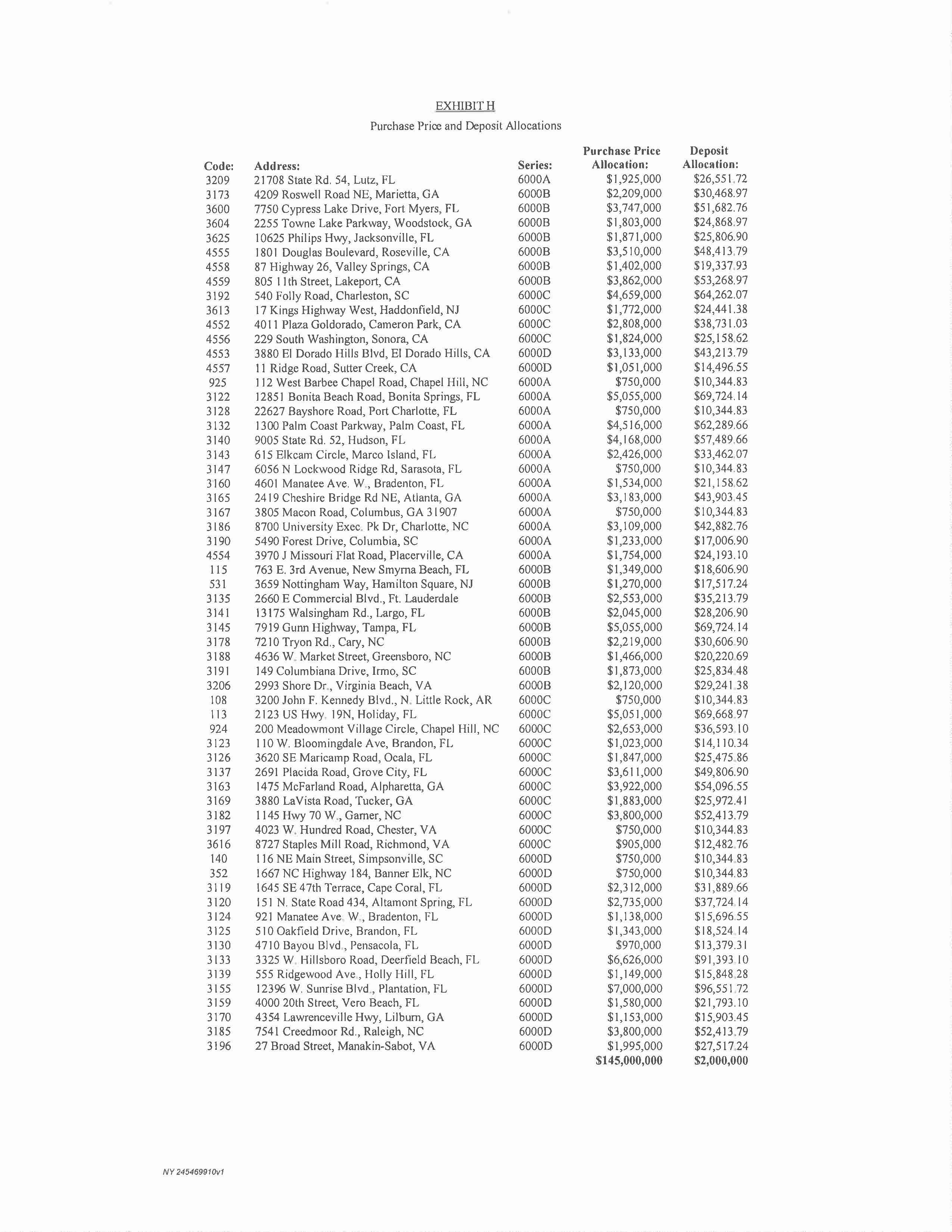
EXHIBIT I
OWNER'S AFFIDAVIT
[Attached]
OWNER'S AFFIDAVIT
___________ _ _ , of First States Investors 6000 [A/B/CID] , L.P., a Delaware limited partnership ("Owner"), the Owner of the premises described in Title Commitment No. _______________ (the "Title Commitment"), and in consideration of First American Title Insurance Company (the "Company") issuing its policy of title insurance insuring an interest in the real estate
described therein, and being first duly sworn on oath, states as follows:
1. | That no proceedings in bankruptcy or receivership have been instituted by or against the Owner within the last ten (10) years, and that the Owner has never made an assignment for the benefit of creditors. |
2. | To Owner's actual knowledge, (i) Owner's charter is in full force and effect, (ii) no proceeding is pending for Owner's dissolution, and (iii) all license, state franchise, and city corporation taxes, if applicable, due and payable by the Owner have been paid in full. |
3. | That Owner is in sole possession of the Property, and that no other party has possession, or has a right of possession under any tenancy, lease or other agreement, written or oral , other than ______________, as a tenant under an unrecorded lease. [The tenant has no rights to the Property other than as tenant, nor any option or rights of first refusal to purchase the Property.] [The tenant has a [right of first offer/refusal] [option] to purchase the Property.] |
4. | That Owner has not contracted for, nor received any notice regarding, and does not know of any improvement, alteration or change to be made in or about the Property, and there has not been any new construction or major repair work performed on the Property for at least [_____________ days/months] for which the Owner has contracted, which could give rise to a mechanic's or materialman's lien on the Property. |
5. | That there are not any recorded or unrecorded mortgages, home improvement loans, chattel mortgages, conditional bills of sale , retention of title agreements, security agreements, agreements not to sell or encumber, financing statements, or personal property leases, which affect the Property or which affect any fixtures, appliances, or equipment now installed in or on the Property, other than as shown on the Title Commitment. |
6. | That the Company has been requested to issue its policy or policies of title insurance referenced above in favor of the Insured named therein. |
For purposes hereof, the "actual knowledge" of Owner shall be limited to the actual knowledge (and not implied, imputed, or constructive) of [________________], with no duty of inquiry .
Notwithstanding anything contained herein to the contrary, the representations and warranties set forth in this Title Affidavit shall only survive the closing of the transactions contemplated by the Purchase Agreement for a period of thirty (30) days after which date this Title Affidavit shall be of no further force or effect and First American Title Insurance Company shall have no further rights hereunder (notwithstanding that one or more of the representations and/or warranties set forth herein may prove to be incorrect). This Title Affidavit is being executed for the sole and exclusive benefit of First American Title Insurance Company and no other party or person shall have any rights hereunder.
Executed as of ____________, 2015.
OWNER:
FIRST STATES INVESTORS 6000 [A/B/C/D], L.P.,
a Delaware limited partnership
By: _____________________________
STATE OF _____________ :
:SS.
COUNTY OF ____________ :
Subscribed and sworn to (or affirmed) before me on this ____________ day of _______________________, 2015, by ___________________, personally known to me or proved to me on the basis of satisfactory evidence to be the person who appeared before me.
________________________________________
(Notary Public)
EXHIBIT J
Additional Permitted Exceptions
(i) the Leases, any new leases or occupancy agreements entered into by Seller in accordance with this Agreement, if any, and all rights of the Tenants under the Leases and such new leases and occupancy agreements;
(ii) all present and future zoning , building, environmental and other laws with respect to the Properties, including, without limitation, landmark designations and all zoning variances and special exceptions, if any;
(iii) liens, encumbrances, Violations and defects, including, without limitation, any contractor's, mechanics and/or materialmen's lien and any judgment arising as a result thereof, leasehold mortgages, security interests and similar title matters the removal of which is an obligation of a Tenant;
(iv) all presently existing and future liens for real estate taxes, assessments and water and sewer charges which although a lien, are not due and payable as of the Closing Date, subject to adjustment as herein provided;
(v) state of facts shown on or by an accurate current survey of the Properties (collectively, "Facts"), provided that, solely with respect to such Facts, the same shall not have a material adverse effect on the use of the Properties for their respective current use;
(vi) standard exclusions from coverage contained in the form of title policy or "marked-up" title commitment employed by the Title Company;
(vii) any lien or encumbrance arising out of the acts or omissions of Purchaser and any Purchaser's employees, agents, consultants, engineers, architects and surveyors;
(viii) any other matter which the Title Company may raise as an exception to title, provided the Title Company will either omit or affirmatively insure against collection or enforcement of same out of the Properties, and that no prohibition of present use or maintenance of the Properties or maintenance of the Improvements will result therefrom, as may be applicable;
(ix) any exception to title set forth in the Continuation for which Purchaser does not send to Seller a Subsequent Title Objection Notice in accordance with Article 6 hereof; and
(x) any exceptions to title set forth in any Continuation for which Purchaser does send to Seller a Subsequent Title Objection Notice, but which are not cured or caused to be insured over by Seller and which Purchaser accepts as exceptions to title to the Properties in accordance with the provisions hereof.
EXHIBIT K
LIST OF PARCELS BY ADDRESS
State | City | Address | Property |
AR | N. Little Rock | 3200 John F. Kennedy Blvd. | 0108 -PARK HILL |
CA | Cameron Park | 40 II Plaza Goldorado | 4552 -CAMERON PARK |
CA | EI Dorado Hills | 3880 El Dorado Hills Blvd | 4553 -EL DORADO HILLS BRANCH |
CA | Lakeport | 805 11th Street | 4559 -LAKE COMMUNITY BRANCH |
CA | Placerville | 3970 J Missouri Flat Road | 4554 -WEST PLACERVILLE BRANCH |
CA | Roseville | 1801 Douglas Boulevard | 4555 -ROSEVILLE BRANCH |
CA | Sonora | 229 South Washington | 4556 -SONORA BRANCH |
CA | Sutter Creek | 11 Ridge Road | 4557 -SUTTER CREEK |
CA | Valley Springs | 87 Highway 26 | 4558 -VALLEY SPRINGS |
FL | Altamont Spring | 151 N. State Road 434 | 3120 -ALTAMONTE CROSSING |
FL | Bonita Springs | 12851 Bonita Beach Road | 3122 -BERNWOOD PARK |
FL | Bradenton | 921 Manatee Ave. W. | 3124 -BRADENTON CITY |
FL | Bradenton | 4601 Manatee Ave. W. | 3160 -WEST BRADENTON |
FL | Brandon | 510 Oakfield Drive | 3125 -BRANDON |
FL | Brandon | 110 W. Bloomingdale Ave | 3123 -BLOOMINGDALE |
FL | Cape Coral | 1645 SE 47th Terrace | 3119 -47TH TERRACE OFFICE |
FL | Deerfield Beach | 3325 W. Hillsboro Road | 3133 -DEERFIELD BEACH (H.S.) |
FL | Fort Lauderdale | 2660 E Commercial Blvd. | 3135 -EAST COMMERCIAL BOULEVARD |
FL | Fort Myers | 7750 Cypress Lake Drive | 3600 -CYPRESS LAKE DRIVE |
FL | Grove City | 2691 Placida Road | 3137 -GROVE CITY OFFICE |
FL | Holiday | 2123 US Hwy. 19N | 0113 -HOLIDAY |
FL | Holly Hill | 555 Ridgewood Ave. | 3139 -HOLLY HILL OFFICE |
FL | Hudson | 9005 State Rd. 52 | 3140 -HUDSON OFFICE |
FL | Jacksonville | 10625 Philips Hwy | 3625 -THE AVENUES |
FL | Largo | 13175 Walsinzham Rd. | 3141 -LARGO OFFICE |
FL | Lutz | 21708 State Rd. 54 | 3209 -LAND O'LAKES OFFICE |
FL | Marco Island | 615 Elkcam Circle | 3143 -MARCO ISLAND OFFICE |
FL | New Smyrna Beach | 763 E. 3rd Avenue | 0115 -NEW SMYMA BEACH |
FL | Ocala | 3620 SE Maricamp Road | 3126 -CEDAR SHORES OFFICE |
FL | Palm Coast | 1300 Palm Coast Parkway | 3132 -CYPRESS POINT |
FL | Pensacola | 4710 Bayou Blvd. | 3130 -CORDOVA-PENSACOLA |
FL | Plantation | 12396 W. Sunrise Blvd. | 3155 -SAWGRASS |
FL | Port Charlotte | 22627 Bavshore Road | 3128 -CHARLOTTE HARBOR OFFICE |
FL | Sarasota | 6056 N Lockwood Ridge Rd. | 3147 -NORTH LOCKWOOD RIDGE |
FL | Tampa | 7919 Gunn Highway | 3145 -NEW CITRUS PARK |
FL | Vera Beach | 4000 20th Street | 3159 -VERO-WEST |
GA | Alpharetta | 1475 McFarland Road | 3163 -BLUEGRASS OFFICE |
GA | Atlanta | 2419 Cheshire Bridge Rd NE | 3165 -CHESHIRE SHERIDAN |
GA | Columbus | 3805 Macon Road | 3167 -EDGEWOOD |
GA | Lilburn | 4354 Lawrenceville Hwy | 3170 -LILBURN OFFICE |
GA | Marietta | 4209 Roswell Road NE | 3173 -PROVIDENCE SQUARE |
GA | Tucker | 3880 LaVista Road | 3169 -LAVISTA ROAD |
GA | Woodstock | 2255 Towne Lake Parkway | 3604 -WOODSTOCK CROSSING |
NC | Banner Elk | 1667 NC Highway 184 | 352 -BANNER ELK |
NC | Cary | 7210 Tryon Rd . | 3178 -ASHLEY VILLAGE |
NC | Chapel Hill | 200 Meadowmont Village Circle | 924 -VILLAGE CIRCLE |
NC | Chapel Hill | 112 West Barbee Chapel Road | 925 - BARBEE CHAPEL ROAD |
NC | Charlotte | 8700 University Exec. Pk Dr | 3186 -UNIVERSITY PLACE OFF |
NC | Garner | 1145 Hwy 70 W. | 3182 -GARNER OFFICE |
NC | Greensboro | 4636 W. Market Street | 3188 -WEST MARKET STREET |
NC | Raleigh | 7541 Creedmoor Rd. | 3185 -STONEHENGE OFFICE |
NJ | Haddonfield | 17 Kings Highway West | 3613 -HADDONFIELD-KINGS |
NJ | Hamilton Square | 3659 Nottingham Way | 0031 -HAMILTON SQUARE |
SC | Charleston | 540 Folly Road | 3192 -JAMES ISLAND |
SC | Columbia | 5490 Forest Drive | 3190 -FOREST DRIVE OFFICE |
SC | Irmo | 149 Columbiana Drive | 3191 -HARBISON OFFICE |
SC | Simpsonville | 116 NE Main Street | 0140 -SIMPSONVILLE MN |
VA | Chester | 4023 W. Hundred Road | 3 197 -CHESTER |
VA | Manakin-Sabot | 27 Broad Street | 3196 -CENTERVILLE |
VA | Richmond | 8727 Staples Mill Road | 3616 -STAPLES MILL |
VA | Virginia Beach | 2993 Shore Dr. | 3206 -VIRGINIA BEACH SHORE |
EXHIBIT L
Title Policy Responsibility
Purchaser:
• | 4636 W Market St, Greensboro, NC 27407 - Guilford County |
• | 7210 Tryon Rd, Cary, NC 2751 I - Wake County |
• | 200 Meadowmont Village Cir, Chapel Hill, NC 275 17 - Orange County |
• | 112 W Barbee Chapel Rd, Chapel Hill, NC 275 I7 - Orange County |
• | 1145 US Highway 70 W, Garner, NC 27529 - Wake County |
• | 8700 University Exec Park Dr, Charlotte, NC 28262 - Mecklenburg County |
• | 1667 Tynecastle Hwy, Banner Elk, NC 95252 - Watauga County |
• | 7541 Creedmoor Rd, Raleigh, NC 95453 - Wake County |
• | 17 Kings hwy W, Haddonfield, NJ 8033 - Camden County |
• | 3659 Nottingham Way, Hamilton Square, NJ 8690 - Mercer/Burlington County |
• | 116 NE Main St, Simpsonville, SC 27407 - Greenville County |
• | 5490 Forest Dr, Columbia, SC 29206 - Richland County |
• | 149 Columbiana Dr, Irmo, SC 292 I2 - Richland County |
• | 540 Folly Rd, Charleston, SC 294 I2 - Charleston County |
Seller:
• | 3200 John F Kennedy Blvd, N. Little Rock, AR 721 16 - Pulaski County |
• | 87 S hwy 26, Valley Springs, CA 95252 - Calaveras County |
• | 229 S Washington St, Sonora, CA 95370 - Tuolumne County |
• | 805 11th St, Lakeport, CA 95453 - Lake County |
• | 3880 El Dorado Hills Blvd, El Dorado Hills , CA 95661 - El Dorado County |
• | 1801 Douglas Blvd, Roseville, CA 95661 - Placer County |
• | 3970 Missouri Flat Rd, Placerville, CA 95667 - El Dorado County |
• | 4011 Plaza Goldorado Cir, Cameron Park, CA 95682 - El Dorado County |
• | 11 Ridge Rd, Sutter Creek, CA 95685 - Amador County |
• | 4710 Bayou Blvd, Pensacola, FL 8690 - Escambia County |
• | 4000 20th St, Vero Beach, FL 23103 - Indian River County |
• | 1300 Palm Coast Pkwy SW, Palm Coast, FL 32137 - Flagler County |
• | 763 E 3rd Ave, New Smyrna Beach, FL 32169 - Voluisa County |
• | 555 Ridgewood Ave, Holly Hill, FL 32256 - Voluisa County |
• | 10625 Philips Hwy, Jacksonville, FL 32256 - Duval County |
• | 151 N State Rd 434 , Altamonte Springs, FL 33308 - Seminole County |
• | 110 W Bloomingdale Ave, Brandon, FL 33511 - Hillsborough County |
• | 510 Oakfield Dr, Brandon, FL 33511 - Hillsborough County |
• | 21708 State Rd 54, Lutz, FL 33549 - Hillsborough County |
• | 7919 Gunn hwy, Tampa, FL 33626 - Hillsborough County |
• | 1645 SE 47th Ter, Cape Coral, FL 33774 - Lee County |
• | 13175 Walsingham Rd, Largo, FL 33774 - Pinellas County |
Page 1 of 2
• | 7750 Cypress Lake Dr, Fort Myers, FL 33907 - Lee County |
• | 22627 Bayshore Rd, Port Charlotte, FL 33980 - Charlotte County |
• | 12851 Bonita Beach Rd Se, Bonita Springs, FL 34135 - Lee County |
• | 921 Manatee Ave W, Bradenton, FL 34205 - Manatee County |
• | 4601 Manatee Ave W, Bradenton, FL 34209 - Manatee County |
• | 2691 Placida Rd, Grove City, FL 34224 - Charlotte County |
• | 3620 SE Maricamp Rd, Ocala, FL 34471 - Marion County |
• | 9005 State Rd 52, Hudson, FL 34669 - Paseo County |
• | 2123 US Hwy 19, Holiday, FL 34691 - Paseo County |
• | 2660 E Commercial Blvd, Fort Lauderdale, FL 33308 - Broward County |
• | 3325 W Hillsboro Blvd, Deerfield Beach, FL 33626 - Broward County |
• | 12396 W Sunrise Blvd, Plantation, FL 33907 - Broward County |
• | 615 E Elkcam Cir, Marco Island, FL 34145 - Collier County |
• | 6056 N Lockwood Ridge Rd, Sarasota, FL 34243 - Sarasota County |
• | 2993 Shore Dr, Virginia Beach, VA 23103 - Virginia Beach City County |
• | 8727 Staples Mill Rd, Richmond, VA 23228 - Richmond City County |
• | 4023 W Hundred Rd, Chester, VA 23831 - Chesterfield County |
• | 27 Broad St Rd, Manakin-Sabot, VA 30062 - Goodchland County |
• | 4354 Lawrenceville Hwy NW, Lilburn, GA 27511 - Gwinnett County |
• | 1475 McFarland Pkwy, Alpharetta, GA 30005 - Fulton County |
• | 4209 Roswell Rd, Marietta, GA 30062 - Cobb County |
• | 3880 LaVista Rd, Tucker, GA 30084 - DeKalb County |
• | 2255 Towne Lake Pkwy, Woodstock, GA 30189 - Cherokee County |
• | 2419 Cheshire Bridge Rd NE, Atlanta, GA 30324 - Fulton County |
• | 3805 Macon Rd, Columbus, GA 31907 - Muscogee County |
Page 2 of 2
EXHIBIT M
FORM OF NOTICE TO TENANT(S)
NOTICE TO TENANTS
As of ______________ _____, 2015
Re: Notice of Change of Ownership of
[ADDRESS]
[CITY], [STATE] [ZIP]
Ladies and Gentlemen:
You are hereby notified as follows:
That as of the date hereof, First States Investors 6000 [A/B/C/D], L.P. has transferred, sold, assigned, and conveyed all of its interest in and to the above-described property, (the "Property") to __________________ (the "New Owner").
Future notices with respect to your leased premises at the Property should be made to the New Owner in accordance with your lease terms at the following address:
[Name of Purchaser]
[c/o _____________]
[________________]
[________________]
Future rental payments with respect to your leased premises at the Property should be made to the New Owner in accordance with your lease terms at the following address:
[Bank address]
Account Name: [___________________]
[BANK]
Account No. [__________]
(Signature page follows)
Sincerely,
First States Investors 6000 [A/B/C/D], L.P.,
a Delaware limited partnership
By: _____________________________
EXHIBIT N
LIST OF EXISTING LOAN DOCUMENTS
(see attached)
LOAN SERIES 6000A |
The following loan series 6000A loan documents are dated as of September 18, 2007 and made between First States Investors 6000A, L.P. ("Borrower A"), as borrower, and LaSalle Bank National Association ("Original Lender A"), as lender, unless otherwise noted:
1A. | Loan Approval Letter, dated September 12,2007, made by Original Lender A; |
2A. | Loan and Security Agreement; |
3A. | Amendment of Loan and Security Agreement, dated October 24, 2007; |
4A. | $26,400,000.00 Promissory Note; |
5A. | Guaranty of Recourse Obligations made by First States Group, L.P. ("Guarantor A") for the benefit of Original Lender A; |
6A. | Environmental Indemnity made by Guarantor A for the benefit of Original Lender A; |
7A. | Manager's Consent and Subordination of Management Agreement made among Borrower A, First States Management Corp., L.P. and Original Lender A; |
8A. | Post-Closing Agreement; |
9A. | Note Splitter Agreement, dated May 8, 2013, made between Borrower A and Wells Fargo Bank, N.A., as Trustee, for the Registered Holders of Bane of America Commercial Mortgage Inc., Commercial Mortgage Pass-Through Certificates, Series 2008-LS 1 ("Defeasance A"); |
l0A. | $1,300,000 Defeasance Promissory Note, dated May 8, 2013, made by Borrower A for the benefit of Defeasance A; |
11A. | $24,949,970.90 Remaining Promissory Note, dated May 8, 2013, made by Original Lender A for the benefit of Defeasance A; |
12A. | Defeasance Assignment, Assumption and Release Agreement, dated May 8, 2013, among Borrower A, SB DFZ Southeast Bank Portfolio A Holdings, LLC, Defeasance A, Bank of America, N.A. ("Servicer A") and acknowledged by Wilmington Trust Company ("Intermediary A"); |
13A. | Defeasance Pledge and Security Agreement, dated May 8, 2013, made by Borrower A for the benefit of Defeasance A and acknowledged by Intermediary A; |
14A. | Defeasance Waiver and Consent, dated May 8, 2013, made between Borrower A and Defeasance A; |
15A. | Defeasance Account Agreement, dated May 8, 2013, made among Borrower A, Intermediary A, Defeasance A and Servicer A; |
16A. | Certificate of Borrower, dated May 8, 2013, made by Borrower A; |
17A. | Defeasance Report for the Orange City - Orange City, FL Promissory Note First Partial Defeasance as made by causey Demgen & Moore P.C.; |
18A. | Final Closing Statement, dated May 8th; and |
19A. | Operation of Primary Purpose Fund, dated May 8, 2013. |
[EXHIBIT N, LIST OF EXISTING LOAN DOCUMENTS,
CONTINUES ON FOLLOWING PAGE]
LOAN SERIES 6000B |
The following loan series 6000B loan documents are dated as of May 11, 2007 and made between First States Investors 6000B, L.P . ("Borrower B"), as borrower, and German American Capital Corporation ("Original Lender B"), as lender, unless otherwise noted:
lB. | Loan and Security Agreement; |
2B. | $30,009,000.00 Promissory Note; |
3B. | Guaranty of Recourse Obligations made by First States Group, L.P. ("Guarantor B") for the benefit of Original Lender B; |
4B. | Environmental Indemnity made by Guarantor B for the benefit of Original Lender B; |
5B. | Manager's Consent and Subordination of Management Agreement made among Borrower B, First States Management Corp., L.P. ("Manager B") and Original Lender B and attaching Property Management Agreement made between Borrower B and Manager B; |
6B. | Certification Regarding Property Documents and Financial Information; |
7B. | Account and Control Agreement made among Borrower B, PNC Bank, National Association and Original Lender B; |
8B. | Request for Taxpayer Identification Number (W-9) made by Borrower B; |
9B. | Disbursement Authorization made by Borrower B; |
l0B. | Escrow Agreement, dated May 10, 2007, from Winston & Strawn LLP to Chicago Title Insurance Company, as Recording Agent and/or Title Company, and Chicago Title Insurance Company, as Escrow Agent; |
11 B. | Flood Certification made by Stewart Lender services for the benefit of Deutsche Bank Mortgage; |
12B. | Anti-Coercion Statement, dated May 3, 2007, made by Borrower B; |
13B. | Post-Closing Agreement; |
14B. | Affidavit of Execution and Delivery Outside the State of Florida, dated May 3, 2007, made by Edward 1. Matey, Jr.; |
15B. | Lender's Intangible Recording Tax Apportionment Affidavit, dated May __, 2007, made by Michelle Leighton and Joanne Mertini; |
16B. | Consent Agreement, dated April 1, 2008, between Wells Fargo Bank, N.A., as Trustee for the Registered Holders of COMM 2007-C9 Commercial Mortgage Pass-Through Certificates and Borrower B; and |
17B. | Letter, dated as of June 19, 2012, from KeyBank Real Estate Capital to Borrower B with respect sub-servicing agreement with Berkadia Commercial Mortgage LLC. |
[EXHIBIT N, LIST OF EXISTING LOAN DOCUMENTS,
CONTINUES ON FOLLOWING PAGE]
LOAN SERIES 6000C |
The following loan series 6000C loan documents are dated as of September 18, 2007 and made between First States Investors 6000C, L.P. ("Borrower C"), as borrower, and LaSalle Bank National Association ("Original Lender C"), as lender, unless otherwise noted:
1C. | Loan and Security Agreement; |
2C. | Amendment of Loan and Security Agreement, dated October 24, 2007; |
3C. | $22,710,000.00 Promissory Note; |
4C. | Guaranty of Recourse Obligations made by First States Group, L.P. ("Guarantor C") for the benefit of Original Lender C; |
5C. | Environmental Indemnity made by Guarantor C for the benefit of Original Lender C; |
6C. | Manager's Consent and Subordination of Management Agreement made among Borrower C, First States Management Corp., L.P. and Original Lender C; and |
7C. | Post-Closing Agreement. |
[EXHIBIT N, LIST OF EXISTING LOAN DOCUMENTS,
CONTINUES ON FOLLOWING PAGE]
LOAN SERIES 6000D |
The following loan series 6000D loan documents are dated as of May 11, 2007 and made between First States Investors 6000D, L.P . ("Borrower D"), as borrower, and German American Capital Corporation ("Original Lender D"), as lender, unless otherwise noted:
1D. | Loan and Security Agreement; |
2D. | $31,275,000.00 Promissory Note' |
3D. | Guaranty of Recourse Obligations made by First States Group, L.P. ("Guarantor D") for the benefit of Original Lender D; |
4D. | Environmental Indemnity made by Guarantor D for the benefit of Original Lender D; |
5D. | Manager's Consent and Subordination of Management Agreement made among Borrower D, First States Management Corp., L.P. ("Manager D") and Original Lender D and attaching Property Management Agreement made between Borrower D and Manager D ; |
6D. | Certification Regarding Property Documents and Financial Information; |
7D. | Account and Control Agreement made among Borrower 0 , PNC Bank, National Association and Original Lender D; |
8D. | Request for Taxpayer Identification Number (W-9) made by Borrower D; |
9D. | Disbursement Authorization made by Borrower B; |
10D. | Escrow Agreement, dated May 10, 2007, from Winston & Strawn LLP to Chicago Title Insurance Company, as Recording Agent and/or Title Company, and Chicago Title Insurance Company, as Escrow Agent; |
11D. | Flood Certification made by Stewart Lender services for the benefit of Deutsche Bank Mortgage; |
12D. | Anti-Coercion Statement, dated May 3, 2007, made by Borrower D; |
13D. | Post-Closing Agreement; |
14D. | Affidavit of Execution and Delivery Outside the State of Florida, dated May 3, 2007, made by Edward 1. Matey, Jr.; |
15D. | Lender's Intangible Recording Tax Apportionment Affidavit made by Michelle Leighton and Joanne Mertini; and |
16D. | Consent Agreement, dated April 1, 2008, between Wells Fargo Bank, N.A., as Trustee for the Registered Holders of COMM 2007-C9 Commercial Mortgage Pass-Through Certificates and Borrower D. |
EXHIBIT O
LITIGATION AND CONDEMNATION
Property: 3196 - Centerville
Address: 27 Broad Street, Manakin-Sabot, Virginia 23103
Two partial takings evidenced by the Certificates of Take filed by the Department of Transportation of the Commonwealth of Virginia with the Clerk's Office of Goochland County as Instrument #090002506 and Instrument #110001691, which have been settled for a total award of $344,000 (collectively, the "Centerville Condemnation"). The tenant, SunTrust Bank, will be reimbursed for restoration work pursuant to the terms of its Lease in the amount of $177,875.74. After deducting legal fees and title company charges of $5,362.48, Seller will retain the remaining $160,761.78 of the condemnation award.
EXHIBIT "P-1"
FORM OF MULTI-PROPERTY TRANSFER NOTICE
FIRST STATES INVESTORS 6000[A/B/C/D), L.P.
c/o Gramercy Property Trust
521 Fifth Ave, 30th Floor
New York, NY 10175
_______ __, 2015
[VIA OVERNIGHT COURIER SERVICE]
[TENANT]
[ADDRESS]
Re: | Lease dated [____________] (the "Lease"), by and between |
[____________], a [__________________] ("Landlord"), and
[____________] ("Tenant");
Property Address: ____________________________ (the
"Premises");
Ladies and Gentlemen:
Please accept this letter as Landlord's Notice pursuant to the [Right of First Offer (Purchaser) Rider to] [Article XXVI off the Lease. Landlord intends to sell the Premises as part of a multi-property transaction. Upon the sale of the Premises, you shall receive notice of the transfer, listing the successor landlord and directing you where to send future rental payments.
Very truly yours,
FIRST STATES INVESTORS 6000[A/B/C/D], L.P.,
a Delaware limited partnership
By: _________________________________
David E. Snyder,
Chief Financial Officer
cc: | Allan B. Rothschild (rothschild@gptreit.com) |
James Chiboucas, Esq. (jchiboucas@kbsrealty.com)
____________________________________
1 Note to draft: Reference to be used for Hamilton Square Notice only.
EXHIBIT "P-2"
FORM OF ROFO NOTICE
FIRST STATES INVESTORS 6000[A/B/C/D), L.P.1
c/o Gramercy Property Trust
521 Fifth Ave, 30th Floor
New York, NY 10175
_______ __, 2015
[VIA OVERNIGHT COURIER SERVICE]
[TENANT]
[ADDRESS]
Re: | Right of First Offer (Purchase): Lease dated [____________] (the |
"Lease"), by and between [____________], a [__________________]
("Landlord"), and [____________] ("Tenant");
Property Address: ____________________________ (the
"Premises");
Ladies and Gentlemen:
Please accept this letter as Landlord's Notice pursuant to [Right of First Offer (Purchase) Rider to] [Article IX of]2 the Lease. Landlord has entered into an agreement to convey the Premises to a third party purchaser that is not an affiliate of Landlord for $[______________]3 (the "Purchase Price") as part of a multi-property transaction. Annexed hereto as Exhibit A is a form of agreement of sale (the "Form of PSA") upon which Landlord is willing to sell the Premises.
If Tenant desires to purchase the Premises at the Purchase Price and upon the terms and conditions set forth in the Form of PSA, Tenant shall so notify Landlord in writing no later than _________________, 20154 (the "ROFO Exercise Date") and pay to Landlord a deposit in an amount equal to I0% of the Purchase Price. Failure to notify Landlord of Tenant's desire to exercise its right of first offer on or prior to the ROFO Exercise Date shall be deemed as Tenant's desire not to purchase the Premises and Landlord shall convey the Premises free and clear of Tenant's rights under [the Right of First Offer (Purchase) Rider to]
[Article IX of]5 the Lease.
.
____________________________________
1 Note to draft: Indicate the correct Landlord entity.
2 Note to draft: Section reference to be used in the James Island Notice only.
3 Note to draft: Insert purchase price allocated to this property.
4 Note to draft: Insert date 20 days from date Tenant will receive this Notice, except for James Island Notice, insert date 30 days from the date Tenant will receive this Notice.
5 Note to draft: Section reference to be used in the James Island Notice only.
Please notify Landlord of your election to either exercise or waive your right of first offer as soon as possible but no later than the ROFO Exercise Date by delivery to Landlord of a letter in the form attached hereto as Exhibit B. We thank you in advance for your prompt response.
Very truly yours,
FIRST STATES INVESTORS 6000[A/B/C/D], L.P.,
a Delaware limited partnership
By: _________________________________
David E. Snyder,
Chief Financial Officer
cc: | Allan B. Rothschild (rothschild@gptreit.com) |
James Chiboucas, Esq. (jchiboucas@kbsrealty.com)
EXHIBIT A
FORM OF PSA
[See attached]
EXHIBIT B
[TENANT]
[ADDRESS]6
_______ __, 2015
First States Investors 6000[A/B/C/D], L.P.7
c/o Gramercy Property Trust
521 Fifth Ave, 30th Floor
New York, NY 10175
Re: | Right of First Offer (Purchase): Lease dated [____________] (the |
"Lease"), by and between [____________], a [__________________]
("Landlord"), and [____________] ("Tenant");
Property Address: ____________________________ (the
"Premises");8
Ladies and Gentlemen:
Capitalized terms used and not defined herein shall have the meanings ascribed to them in the Lease.
Tenant hereby acknowledges receipt of Landlord's Notice pursuant to [the Right of First Offer (Purchase) Rider to] [Article IX of]9 the Lease.
[Please elect one ofthe paragraphs below and delete the other paragraph:]
[By executing this letter in the space provided below, for good and valuable consideration, the sufficiency of which is hereby acknowledged, Tenant hereby waives its right to purchase the Premises pursuant to [the Right of First Offer (Purchase)
Rider to] [Article IX of]10 the Lease and acknowledges that Landlord shall convey the Premises free and clear of Tenant's rights under [the Right of First Offer (Purchase) Rider to] [Article IX of]11 the Lease.]
[By executing this letter in the space provided below, for good and valuable consideration, the sufficiency of which is hereby acknowledged, Tenant hereby elects, pursuant to [the Right of First Offer (Purchase) Rider to] [Article IX of]12 the Lease,
____________________________________
6 Note to draft: Insert Tenant's name and address from the first page.
7 Note to draft: Indicate the correct Landlord entity.
8 Note to draft: Complete with information provided on the first page.
9 Note to draft: Section reference to be used in the James Island Notice only.
10 Note to draft: Section reference to be used in the James Island Notice only.
11 Note to draft: Section reference to be used in the James Island Notice only.
12 Note to draft: Section reference to be used in the James Island Notice only.
to purchase the Premises for $[___________]13 and upon the terms and conditions set forth in the agreement of sale attached hereto, and shall pay to Landlord a deposit in an amount equal [$_______________]14 no later than __________ ___,201515 (the "ROFO Exercise Date").]
Very truly yours,
_____________________________________
a___________________________
By: _________________________
____________________________________
13 Note to draft: Insert purchase price allocated to this property.
14 Note to draft: Indicate deposit of 10% purchase price.
15 Note to draft: Insert ROFO Exercise Date provided on the first page.