Attached files
| file | filename |
|---|---|
| 8-K - FORM 8-K - URANERZ ENERGY CORP. | form8k.htm |
| EX-99.3 - CONSENT OF QUALIFIED PERSON - URANERZ ENERGY CORP. | exhibit99-3.htm |
| EX-99.1 - PRESS RELEASE DATED OCTOBER 14, 2010 - URANERZ ENERGY CORP. | exhibit99-1.htm |
| Technical Report |
| Reno Creek Property |
| Campbell County, Wyoming, U.S.A. |
NI 43-101 Technical Report
Prepared for:
Uranerz Energy Corporation
1701 East "E" Street
P.O. Box 50850
Casper, WY
82605
Prepared by:
Douglass H. Graves, P.E.
TREC, Inc.
951 Werner Court
Suite 395
Casper, WY 82601
October 13, 2010

| Reno Creek Property Technical Report | Page 2 |
| Reno Creek Property Technical Report | Page 3 |
LIST OF FIGURES
LIST OF TABLES
| Reno Creek Property Technical Report | Page 4 |
3. SUMMARY
This technical report ("Technical Report") was prepared by Douglass Graves, P.E. of TREC, Inc. The Author was retained by Uranerz Energy Corporation ("Uranerz") to prepare an independent technical report in Form 43-101F1 of the Canadian Securities Administrators' National Instrument 43-101 – Standards of Disclosure for Mineral Projects ("NI 43-101") for the area comprising the Reno Creek Property ("Property") located in Campbell County, Wyoming, U.S.A. The Author is an independent "qualified person" as defined by NI 43-101.
This Technical Report addresses the uranium mineralization of Uranerz' Reno Creek Property which is located in the southeastern extent of the Pumpkin Buttes region of the Powder River Basin in the state of Wyoming, approximately 80 highway miles northeast of the city of Casper, 40 miles south of Gillette and 9 miles southwest of Wright (see Figure 1). The Reno Creek Property is located within Campbell County, Wyoming in Township 43N, Range 73W, in the S½ of Section 21, SW¼ of Section 22, E½ of Section 28, NE¼ of Section 29, NE¼ of Section 31 and SW¼ of Section 33 of the 6th Prime Meridian which is outlined by the boundary illustrated in Figures 1, 2 and 3. Uranerz has three unpatented lode mining claims and three Surface Use Agreements ("SUA") and 18 fee mineral leases associated with the Reno Creek Property and the area encompassing the claims and fee minerals is approximately 1,312 acres (see Figures 2 and 3).
The host for uranium mineralization within the Reno Creek Property is the lower Wasatch Formation of Eocene age. The Wasatch is a fluvial deposit composed of sandstones interbedded with claystones, siltstones, carbonaceous shale, and thin coal beds. The Wasatch Formation is present at the surface throughout much of the Powder River Basin. It is characterized by continuous sheetlike deposition at the fringes of the basin, whereas the interior of the basin is characterized by lenticular sands, siltstones, and mudstones deposited by medium energy events.
The uranium mineralization at Reno Creek is typical of the Wyoming type roll-front deposits, and the mineral resources occur within the "Reno Creek Target Sand" as designated by Uranerz. The Reno Creek Target Sand ranges in thickness from about 20 feet up to 220 feet in some parts of the property, averaging approximately 100 feet. The Reno Creek Target Sand generally occurs as a single sand body in the northern and eastern portions of the property and occurs as upper and lower sand units separated by 10 to 50 feet of siltstones and shales, towards the southern and western parts of the property. Primary mineralization in the Reno Creek Target Sand occurs within five horizons, designated from shallowest to deepest, the "Green", "Purple", "Red", "Orange" and "Blue" horizons, with mineralization occurring in all horizons in the project area, as illustrated in Figure 5. Depths to the mineralized zones range from 129 to 441 feet below the ground surface depending on the topography and changes in the stratigraphic horizon within the Reno Creek Target Sand.
The drilling data demonstrate that mineralization occurs along a roll front that generally trends northeast-southwest at the Reno Creek Property. This mineralization occurs in the Reno Creek Target Sand. Drilling data also indicate minor discontinuous mineralization occurring in a shallower horizon which was not included in this mineral resource estimate.
Mining leases were first obtained in the Reno Creek Project area by Rocky Mountain Energy ("RME") sometime before 1968. Exploration drilling was conducted in the Uranerz project area between 1968 and 1991 by RME and 1993 and 1994 by Energy Fuels Nuclear ("EFN"). A total of 768 exploration holes and 31 wells were drilled during these periods. In 2010 Uranerz drilled
| Reno Creek Property Technical Report | Page 5 |
an additional 49 exploration holes (to confirm the historic drilling) and one water well.
This Technical Report presents an independent estimate of measured, indicated, and inferred mineral resources as defined in Section 1.2 of NI 43-101. Mineral resources are not mineral reserves and do not have demonstrated economic viability. The estimated mineral quantity and grade described in this NI 43-101 Technical Report are calculated using accepted protocols. Therefore, these estimates meet the NI 43-101 classification of "measured", "indicated" or "inferred" mineral resources as defined by NI 43-101 and the Canadian Institute of Mining, Metallurgy and Petroleum Definitions Standards incorporated by reference therein.
Data available for the resource estimate presented in this Technical Report include information from 747 of the 768 historical exploration holes, 31 historical wells, 49 recent exploration drill holes and one recent well, for a total of 848 holes. From the drilling described above, the information included hardcopies and scanned electronic copies of lithologic and geophysical logs, mineralization intercept grade calculations, drill hole maps and electronic and hard copies of stratigraphic cross-sections constructed from historic geophysical logs. Figures 7, 8, and 9 provide stratigraphic cross sections. Data from 21 exploration drill holes in the SW of Section 33 supplied by Uranerz included only mineralization intercept data. Geophysical and lithologic logs, drill hole map and cross section data were not provided for this Section and consequently the mineralization data could not be verified and was not used for the development of this resource estimate. It should be noted that the mineralization data in the SW of Section 33 was minimal and would not have significantly affected the resource estimate. In addition, data from various historic unpublished reports were evaluated and used in developing the mineral resource estimate at Reno Creek. A list of these reports is provided in Section 4.5 of this technical report.
The mineral resource estimates shown below were calculated by GT (Grade x Thickness) contour method using a minimum grade cutoff of 0.03% eU3O8and a minimum mineralization thickness of 1.0 feet. The GT values of the subject sand intervals for each hole were plotted on a drill hole map and contour lines were drawn along the general mineralization trend (see Figures 7, 8, and 9). The areas within the GT = 0.2 contour boundaries were used for calculating resource estimates. Based on results of Uranerz confirmation drilling which validated historic drilling data, measured resources were determined within the area of influence of all historic and recent drill hole locations. The mineral resources are reported based on GT cutoffs of 0.20 and 0.50. The 0.20 GT cutoff is recommended for reporting purposes and is presented in the following table. The 0.5 GT cutoff has been used to highlight areas of highest mineralization.
The current stated estimate of mineral resources for the Reno Creek Property follows:
| Reno Creek Property Technical Report | Page 6 |
Table 3-1 Reno Creek Summary of Resources
| Measured Resource | ||||||||||||
| Horizon ID. | Green | Purple | Red | Orange | Blue | TOTAL | ||||||
| GT Minimum | 0.2 | 0.5 | 0.2 | 0.5 | 0.2 | 0.5 | 0.2 | 0.5 | 0.2 | 0.5 | 0.2 | 0.5 |
| eU3O8 Pounds | 239,594 | 122,530 | 443,675 | 283,653 | 1,452,243 | 1,163,885 | 569,376 | 358,445 | 77,320 | 44,910 | 2,782,208 | 1,973,423 |
| Tons | 196,388 | 80,612 | 346,621 | 170,876 | 1,171,164 | 855,798 | 499,453 | 238,963 | 67,825 | 34,023 | 2,281,451 | 1,380,272 |
| Avg. Grade (% eU3O8 ) |
0.061 |
0.076 |
0.064 |
0.083 |
0.062 |
0.068 |
0.057 |
0.075 |
0.057 |
0.066 |
0.061 |
0.071 |
| Indicated Resource | ||||||||||||
| Horizon ID. | Green | Purple | Red | Orange | Blue | TOTAL | ||||||
| GT Minimum | 0.2 | 0.5 | 0.2 | 0.5 | 0.2 | 0.5 | 0.2 | 0.5 | 0.2 | 0.5 | 0.2 | 0.5 |
| eU3O8 Pounds | 120,265 | 25,659 | 177,616 | 49,732 | 663,342 | 457,241 | 454,667 | 233,138 | 94,850 | 39,939 | 1,510,740 | 805,709 |
| Tons | 130,723 | 21,032 | 188,954 | 32,293 | 676,880 | 408,251 | 454,667 | 191,097 | 98,802 | 38,403 | 1,550,026 | 691,076 |
| Avg. Grade (% eU3O8 ) |
0.046 |
0.061 |
0.047 |
0.077 |
0.049 |
0.056 |
0.050 |
0.061 |
0.048 |
0.052 |
0.049 |
0.058 |
| Measured + Indicated Resource | ||||||||||||
| Horizon ID. | Green | Purple | Red | Orange | Blue | TOTAL | ||||||
| GT Minimum | 0.2 | 0.5 | 0.2 | 0.5 | 0.2 | 0.5 | 0.2 | 0.5 | 0.2 | 0.5 | 0.2 | 0.5 |
| eU3O8 Pounds | 359,859 | 148,189 | 621,291 | 333,385 | 2,115,585 | 1,621,126 | 1,024,043 | 591,583 | 172,170 | 84,849 | 4,292,948 | 2,779,132 |
| Tons | 327,111 | 101,644 | 535,575 | 203,169 | 1,848,044 | 1,264,049 | 954,120 | 430,060 | 166,627 | 72,426 | 3,831,477 | 2,071,348 |
| Avg. Grade (% eU3O8 ) |
0.055 |
0.073 |
0.058 |
0.082 |
0.057 |
0.064 |
0.054 |
0.069 |
0.052 |
0.059 |
0.056 |
0.067 |
| Inferred Resource | ||||||||||||
| Horizon ID. | Green | Purple | Red | Orange | Blue | TOTAL | ||||||
| GT Minimum* | 0.2 | 0.5 | 0.2 | 0.5 | 0.2 | 0.5 | 0.2 | 0.5 | 0.2 | 0.5 | 0.2 | 0.5 |
| eU3O8 Pounds | 12,712 | 17,614 | 39,821 | 50,442 | 21,578 | 142,167 | ||||||
| Tons | 15,889 | 16,031 | 64,228 | 66,371 | 27,664 | 190,183 | ||||||
| Avg. Grade (% eU3O8 ) |
0.040 |
0.055 |
0.031 |
0.038 |
0.039 |
0.039 |
||||||
*Inferred Resource at 0.5 GT cutoff not determined
| Reno Creek Property Technical Report | Page 7 |
In the opinion of the Author, the Reno Creek Property represents a potentially viable mineral resource for future development. The Author has the following recommendations for moving the Property towards development:
-
Install additional monitor wells and conduct hydrologic studies including pumping tests, determination of current groundwater levels and hydrologic confinement conditions in order to evaluate the impact of these properties on possible ISR mining. The monitor wells should also be used to determine groundwater quality. Approximate cost: $100,000 to $150,000.
-
Conduct additional radiological disequilibrium with additional uranium spectral analysis logging or coring to develop a site-specific model, and conduct bench scale leach tests to determine amenability to in-situ extraction. Approximate cost: $100,000 to $200,000.
-
Complete an economic evaluation of the project. Approximate cost: $70,000 to $100,000.
-
If results of above recommendations are positive, conduct environmental baseline studies for preparation of state and federal permit/license amendment applications. Approximate cost: $800,000 to $1,000,000.
4. INTRODUCTION AND TERMS OF REFERENCE
4.1 Report Preparation
The following Technical Report was prepared by Douglass Graves, P.E. of TREC, Inc. The Author was retained by the Issuer, Uranerz Energy Corporation ("Uranerz"), to prepare an independent technical report in Form 43-101F1 of the Canadian Securities Administrators' National Instrument 43-101 – Standards of Disclosure for Mineral Projects ("NI 43-101") for the Reno Creek Property located in Campbell County, Wyoming, U.S.A. (see Figures 1 and 2). The Author is an independent "qualified person" as defined by NI 43-101.
4.2 Property Ownership
The private minerals and surface portion of the Reno Creek property was leased by Uranerz Energy Corporation ("Uranerz") between 2006 and 2009. A total of 1,312 acres and 18 mineral owners were involved in the acquisition. The federal and private mineral leases are interspersed throughout the Reno Creek property (see Figure 3).
Uranerz is a "pure play" uranium exploration company based in Casper, Wyoming, U.S.A., incorporated in Nevada. It is listed on the NYSE Amex Equities Exchange (formerly called the American Stock Exchange) and the Toronto Stock Exchange (TSX) under the symbol "URZ". Uranerz is also listed on the Frankfurt Stock Exchange under the symbol "U9E." Uranerz' major activities are focused on its properties in the Powder River Basin of Wyoming, U.S.A., an area well known for hosting uranium-mineralized roll fronts that are amenable to in-situ recovery ("ISR") mining techniques. Uranerz controls approximately 93,115 acres, including 66,972 acres held by Arkose Mining Venture (a joint venture with United Nuclear, LLC, of which Uranerz has an eighty-one percent working interest), in the Powder River Basin and has submitted ISR license and mine permit applications for the Nichols Ranch Uranium In-Situ Recovery Project (the "Nichols Ranch ISR Project") located approximately 19 air miles west of the Reno Creek Property.
| Reno Creek Property Technical Report | Page 8 |
4.3 Purpose of Report
The purpose of this Technical Report is to review the available data for the Reno Creek Property and develop an estimate of mineral resources. This Technical Report conforms to NI 43-101 - Standards of Disclosure for Mineral Projects.
4.4 Terms of Reference
Units of measurement unless otherwise indicated are feet (ft), miles, acres, pounds avoirdupois (lbs.), and short tons (2,000 lbs.). Uranium grade is expressed as weight percent U3O8, thestandard market unit. Grade is reported for historical resources and the mineral resources reported here as percent eU3O8. eU3O8 refers to an assay or grade of equivalent uranium as determined from a gamma ray log. ISR refers to in-situ recovery, also termed ISL or in-situ leach.
4.5 Sources of Information and Data
Rocky Mountain Energy ("RME") and Energy Fuels Nuclear, Inc. ("EFN") performed exploratory drilling in the Reno Creek Property area from 1968 through 1994, as further described in Section 8.2. The results of the historic drilling program are the primary source of information and data for this Technical Report. In addition, Uranerz conducted exploratory drilling at Reno Creek during August and September 2010 and the grade calculations from the geophysical logs of holes drilled by Uranerz were used to supplement the historic data. The findings of this Technical Report are based upon published and unpublished data including:
-
Lithologic and geophysical logs, and gamma count readouts for historic drilling completed by RME and EFN from 1968 through 1994, and subsequent intercept grade calculations;
-
Lithologic and geophysical logs and intercept grade calculations for drilling of 49 holes and one well by Uranerz during August and September 2010;
-
Drill hole location data for historic drilling and 2010 Uranerz drilling;
-
Cross sections constructed from geophysical logs of historical drilling; and
-
Drill hole maps including historic drill hole locations with mineral body outlines and drill hole maps with recent drill hole locations.
A more detailed summary pertaining to the drilling program for the Reno Creek Property is provided in Section 12.
In addition, three reports were evaluated for drill hole locations, the identification and relative position of the host sand (Reno Creek Target Sand), the mineralization trends and historical resource evaluations. These include:
Cheyenne River Partners L.P.'s unpublished report "Progress on the Phase II and Phase III Drilling Programs Reno Creek-Mine Unit I Area, Campbell County, Wyoming, Section 29, T43N, R73W" prepared for Energy Fuels Nuclear in May, 1994 (Cheyenne River Partners, L.P., 1994);
| Reno Creek Property Technical Report | Page 9 |
Rocky Mountain Energy's unpublished report "Disequilibrium Diagrams, Reno Creek ISL Project (27 7020C)" prepared internally in March, 1980 (RME, 1980);
Rocky Mountain Energy's, unpublished report "Reno Creek ISL Consolidation Feasibility Study" prepared internally in April, 1986 (RME, 1986);
Snow, C.'s 43-101 compliant report "Mineral Resource Report, Reno Creek Uranium Property, Campbell County, Wyoming" prepared for Strathmore Minerals Corporation and American Uranium Corporation, Inc., in January 30, 2009 (Snow, 2009a).
4.6 Extent of Author's Field Involvement
Douglass Graves, P.E. visited the site on August 25, 2010 to tour the Reno Creek Property area with Uranerz Geologist Dave Tenney. The site visit was conducted to observe the on-going uranium exploration activities being conducted by Uranerz in the Reno Creek area. Mr. Graves previously visited the Casper, Wyoming office of Uranerz where relevant data were obtained for development of this mineral resource estimate.
5. RELIANCE ON OTHER EXPERTS
The information, conclusions, opinions, and estimates contained herein are based on:
- Information available to TREC, Inc. at the time of preparation of this Technical Report as provided by Kurtis Brown (Uranerz) and Dave Tenney (Uranerz);
- Assumptions, conditions, and qualifications as set forth in this Technical Report;
- Data, reports, and other information supplied by Uranerz and third party sources (to the extent identified and as referenced herein).
For this Technical Report, the Author has relied on property ownership information provided by Uranerz and has not researched property title or mineral rights for the Reno Creek Property. The Author expresses no legal opinion as to the ownership status of the Reno Creek Property.
6. PROPERTY DESCRIPTION AND LOCATION
6.1 Location and Size
The Reno Creek Property is located in the southeast of the Pumpkin Buttes region of the Powder River Basin, in Campbell County, Wyoming at a latitude and longitude of 43 degrees, 40 minutes, North by 105 degrees, 38 minutes, West which is located within Township 43N, Range 73W, in the S½ of Section 21, SW¼ of Section 22, E½ of Section 28, NE¼ of Section 29, NE¼ of Section 31 and SW¼ of Section 33 of the 6th Prime Meridian. The primary mineralization is located within Sections 21, 22, 28, 29 and 31 of T43N, R73W. The property is approximately 9 highway miles southwest of Wright, 40 highway miles south of Gillette, and 80 highway miles northeast of Casper, Wyoming. See Figure 1.
For reference purposes, a normal township consists of 36 sections with each section being one square mile, or six sections by six sections or approximately 36 square miles.
| Reno Creek Property Technical Report | Page 10 |
6.2 Mining Claims and Surface Use Agreements
Within the report area, Uranerz has three unpatented lode mining claims and three Surface Use Agreements ("SUA"). There are 18 fee mineral leases associated with the Reno Creek Property and the area encompassing the claims and fee mineral leases is approximately 1,312 acres. In the S½ of Section 21 and NE¼ of Section 29, T43N, R73W, Uranerz controls 96.875% of the fee mineral estate under the various fee mineral leases mentioned above.
Uranerz' title to the unpatented lode mining claims is subject to the rights of pedis possessio against all third party claimants as long as said claims are maintained. The claims do not have an expiration date. However, affidavits must be filed annually with the federal U.S. Bureau of Land Management ("BLM") and respective county recorder's offices in order to maintain the claims' validity. In addition, most of the above-mentioned unpatented lode mining claims are located on Stock Raising Homestead land where the U.S. government has issued a patent for the surface to an individual and reserved the minerals to the U.S. government subject to the location rights by claimants as set forth in the 1872 Mining Law.
The three SUAs have set provisions for reimbursement to the surface owner for disturbances resulting from Uranerz operations and will remain in effect for as long as Uranerz has agreements covering the mineral estate.
6.3 Legal Surveys
Legal surveys of unpatented lode mining claims are not required, and, to the Author's knowledge, have not been completed to advance the subject property towards patent. The area covered by the SUAs are based on the legal subdivision descriptions as set forth by the U.S. Cadastral Survey and, to the Authors' knowledge, the area covered by the SUAs has not been verified by legal survey.
6.4 Mineralized Areas and Existing Mine Workings
Mineral resources are located in the Eocene age Wasatch Formation in what is identified as the Reno Creek Target Sand. The Reno Creek Target Sand generally occurs as a single sand body in the northern and eastern portions of the property and occurs as upper and lower sand units separated by 10 to 50 feet of siltstones and shales, towards the southern and western parts of the property. Primary mineralization in the Reno Creek Target Sand occurs within five horizons, designated from shallowest to deepest, the "Green", "Purple", "Red", "Orange" and "Blue" horizons. To the Author's best knowledge, there has been no full scale mining production of the Reno Creek deposits.
There has been previous development and operation of a pilot in-situ recovery site adjacent to the subject property as discussed in Section 8.4. The pilot plant was located in the northwest corner of Section 27, T43N, R73W; the plant's concrete foundation and floor slabs still exist and are visible. Other than the pilot plant site, there are no pre-existing mineral processing facilities or related tailings ponds or waste deposits within the subject property. There is currently an exploration drilling permit in effect for the Reno Creek Property (see additional information in Section 6.7) . The proposed Nichols Ranch ISR Project (mining permits applied for from the Wyoming Department of Environmental Quality and the U.S. Nuclear Regulatory Commission) is located 19 air miles west of the Reno Creek Property.
| Reno Creek Property Technical Report | Page 11 |
6.5 Royalties and Encumbrances
Lode mining claims in the Reno Creek area are not subject to royalties. The 18 fee mineral leases have variable royalties that are dependent on the sale price of uranium. Surface Owners have a set rate for reimbursement in respect of any land taken out of service for mining activities.
The unpatented lode mining claims will remain the property of Uranerz provided the company adheres to required filing and annual payment requirements with Campbell County and the BLM. The SUAs will remain in force so long as the mining claims are maintained. Legal surveys of unpatented lode mining claims are not required and are not known to have been completed.
All of the unpatented lode mining claims have annual filing requirements ($140 per claim) with the BLM, to be paid on or before September 1 of each year.
6.6 Environmental Liabilities
The Author is not aware of any environmental assessments having been performed to identify potential environmental issues at the subject property. As such, the Author is not aware of any outstanding environmental issues or liabilities. The only activities that have occurred on the subject property are exploration drilling for uranium, exploration for oil and gas and production of coal bed methane ("CBM") gas. Uranerz' only known existing potential liability is reclamation of exploration drill sites and exploration access roads.
6.7 Required Permits
Exploration
Exploration drilling has been conducted at the Reno Creek Property. The volume and extent of exploration is described in detail in Sections 8.1 and 8.2. Additional exploratory drilling may be conducted by Uranerz to better define mineralization within specified areas of interest. Uranerz has a Notification to Drill permit from the State of Wyoming Department of Environmental Quality/ Land Quality Division ("WDEQ/LQD") for all exploration drilling.
Production
Future mining development will require a number of licenses/permits with the two most significant being (a) the Permit to Mine, issued by the WDEQ/LQD and (b) the Source Material License, required and issued by the U.S. Nuclear Regulatory Commission ("NRC") for mineral processing of natural uranium. In December 2007, Uranerz submitted permit applications for the Permit to Mine and for the Source Material License to the WDEQ/LQD and NRC, respectively, for the Nichols Ranch ISR Project (100% owned by Uranerz) located west of the Reno Creek property. These applications are currently being reviewed by the regulatory oversight agencies. The applications include identification of a central processing plant, satellite plant and well fields to be located west and northwest of the Reno Creek Property. Mining development at Reno Creek would require amendment applications to the Nichols Ranch ISR Project Source Materials License and Permit to Mine, or the development and submission of new license/permit applications for Reno Creek.
The NRC has the responsibility to issue Source Material Licenses to "receive title to, receive, possess, use, transfer, or deliver any source material after removal from its place of deposit in nature" (Code of Federal Regulations ("CFR") 40.1 and 40.3) . "Source nuclear material" is
| Reno Creek Property Technical Report | Page 12 |
defined as uranium and/or thorium in any form, or ores containing 0.05 percent or more by weight uranium and/or thorium. The NRC is responsible for the oversight and implementation of the National Environmental Policy Act ("NEPA") regulations. Pursuant to 10 CFR 51.20, all licenses for new uranium mills (including ISR facilities) will be required to submit a license application that will include an environmental report and a technical report. 10 CFR 51.20 further requires that an Environmental Impact Statement (EIS) be conducted for new uranium mills (including ISR facilities). In June 2009, NRC issued a Generic Environmental Impact Statement ("GEIS") for new uranium ISR operations to meet this requirement. Additional site specific environmental reviews will be conducted at each new site resulting in a supplemental EIS that is tiered off of the GEIS. Environmental baseline information (hydrology, vegetation, wildlife, etc.) on this property would be developed in order to complete the applications for a WDEQ/LQD Permit to Mine and a NRC Source Material License.
Any injection or pumping operations will require permits from the WDEQ which has authority under the Safe Water Drinking Act that stems from a grant of primacy from the U.S. Environmental Protection Agency for administering underground injection control programs in Wyoming.
| 7. |
ACCESSIBILITY, CLIMATE, LOCAL RESOURCES, INFRASTRUCTURE AND PHYSIOGRAPHY |
7.1 Topography, Elevation and Vegetation
The Reno Creek Property is located within the Wyoming Basin physiographic province, in the central portion of the Powder River Basin, within the southeastern portion of the Pumpkin Buttes Mining District. The Pumpkin Buttes are a series of small buttes rising up to nearly 6,000 feet elevation, and approximately 1,000 feet above the surrounding plains. The rock capping the top of the buttes is the Oligocene age White River Formation erosional remnant, which is believed to have overlain the majority of the Powder River Basin. While the volcanic tuffs in the White River Formation have been cited as a possible source of uranium in this basin (Davis, 1969), the White River itself is not considered a uranium resource in this area. The Reno Creek Property is located 13 air miles east of the Pumpkin Buttes.
The Reno Creek Property area consists of low, rolling sagebrush covered grasslands, with scattered intermittent drainages sometimes producing steep channel walls. Elevations range from approximately 5,100 to 5,200 feet above sea level. Figures 1 and 3 illustrate the topography of the subject property.
Historically and currently, the land is used for livestock and wildlife grazing. Vegetation is characteristically sagebrush shrub land and mixed grassland with some deciduous trees within drainages.
7.2 Access
The Reno Creek property is accessible via Wyoming Highway 387 which passes through the property boundary (see Figure 2) in addition to existing private gravel and dirt roads many of which have been improved by CBM development. Some road development and improvements may be required at a later time to facilitate future development of well fields or satellite facilities.
| Reno Creek Property Technical Report | Page 13 |
7.3 Proximity to Population Centers and Transport
The Reno Creek Property is located approximately 40 highway miles south of Gillette, Wyoming, 80 highway miles northeast of Casper and 9 highway miles southwest of the town of Wright. The project is accessed from Wyoming Highway 387 which passes through the project boundary. Well maintained gas-oil field roads and light-duty to unimproved private ranch roads provide site access. The site location is shown on Figures 1 and 2.
7.4 Climate
In the vicinity of the Reno Creek Property, the weather may limit the time periods for capital construction but should not significantly affect the operation of an ISR facility. The climate is semiarid and receives an annual precipitation of approximately 12-15 inches, the majority of which falls from February to April as snow. Cold, wind, and snow/blizzards can make winter exploration and construction work in this area difficult but not impossible. The summer months are typically hot, dry and clear except for infrequent high-intensity, short-duration storm events. The annual mean temperature is 58.3°F, with the January mean being 24.8°F and the July mean of 70.5°F. Temperature extremes range from -30°F to over 100°F (Snow, 2009a).
7.5 Local Resources and Property Infrastructure
As discussed in Section 6.0, Uranerz has secured sufficient surface access rights for exploration and development of the project.
The basic infrastructure (power, water, and transportation) necessary to support an ISR mining operation is located within reasonable proximity of the subject property. Existing infrastructure is associated with local oil, gas, and CBM development. Based upon discussions with the local electrical service provider, overhead power is currently accessible, and additional power for future projects can be made available (Powder River Energy Corp., 2010).
Non-potable water will be supplied by wells developed at or near the site. Water extracted as part of ISR operations will be recycled for reinjection. Typical ISR mining operations also require a disposal well for limited quantities of fluids that cannot be returned to the production aquifers.
The proximity of the Reno Creek Property to paved roads will facilitate transportation of equipment, supplies, personnel, and product to and from the project. The personnel required for exploration, construction, and operation are available in the nearby towns of Wright, Midwest, Edgerton, Gillette, Douglas, and Casper, Wyoming.
No tailings storage areas, waste disposal areas, or heap leach pad(s) will be a part of the infrastructure for the Reno Creek Property, as ISR operations do not require these types of facilities. However, a satellite plant may be constructed, once approved by a Source Material License and Permit to Mine, applications for which have not yet been submitted for Reno Creek.
8. HISTORY
8.1 Ownership History of the Reno Creek Property
In 1968, Rocky Mountain Energy ("RME", subsidiary of Union Pacific Corporation) began a successful drilling exploration program in the region. In the mid 1970's RME formed a joint venture with Mono Power and Halliburton Company to develop the property for mining. The
| Reno Creek Property Technical Report | Page 14 |
joint venture applied for and received a research and development (R&D) test pilot license in 1978 from the NRC and DEQ. Following the successful restoration of the test pilot, RME began application for a deep disposal well and conducted feasibility studies for the property.
Changing economic conditions eventually resulted in RME's sale of the property in 1992 to Energy Fuels Nuclear (EFN). In 1993 and 1994 EFN drilled several hundred pre-mining development holes and selected a location for the processing plant. In 1996 EFN requested NRC to start the license application process. In 1998, EFN was acquired by International Uranium USA Corporation (IUC). IUC evaluated the project and decided in 1999 to withdraw the license application. Then in 2001, IUC sold the property to Rio Algom. Rio Algom held the property until 2002.
In 2002, Power Resources Inc. the U.S. subsidiary of what is now Cameco Resources Inc. acquired the Reno Creek property. Power Resources Inc. held the state permit to mine until it was terminated in 2007. Beginning in 2003 Power Resources began to relinquish their federal claims and leases. In 2004, Strathmore Minerals Corporation (SMC) acquired the Federal minerals portion of the Reno Creek property by staking claims. SMC formed an operating company, American Uranium Corporation which was sold jointly to Bayswater Uranium Corporation (BAYS) and Pacific Road Capital in 2010. A subsidiary of BAYS, NCA Nuclear, is currently operator for the federal minerals portion of the property. See Figure 2 for an illustration of mineral lease control for the area.
The private minerals portion of the Reno Creek property were leased by Uranerz between 2006 and 2009. A total of 1,312 acres and 18 mineral owners were involved in the acquisition. The federal claims and private mineral leases are interspersed throughout the Reno Creek property.
8.2 Exploration and Development Work Undertaken
Mineral leases were first obtained in the Reno Creek Project area by RME sometime before 1968. Exploration drilling was conducted in the Uranerz project area between 1968 and 1991 by RME and 1993 and 1994 by EFN. A total of 768 exploration holes and 31 wells were drilled during these time frames. In 2010 Uranerz drilled 49 exploration holes to confirm the historic drilling and one water well.
8.3 Existing Mineral Resource Estimates and Their Reliability
An unpublished mineral resource study that covered the entire Reno Creek Property (SMC now NCA and Uranerz, leases described above) was completed in 1986 by RME (RME, 1986). This study describes the estimated resources of the property using then available historical drill hole information. This report and the associated resource estimate are considered to be relevant to this project and is the earliest preserved resource report covering the Reno Creek property. The estimated resources were not categorized but were determined by the following addressability parameters and are summarized in Table 8-1.
| Minimum grade | 0.02% U3 O8 |
| Minimum resource thickness | 2.0 feet |
| Minimum internal waste thickness | 2.0 feet |
| Minimum depth below static water level | 20.0 feet |
| Rock density | 17.0 ft3 / ton |
| Disequilibrium ratio | 1.0 |
| Reno Creek Property Technical Report | Page 15 |
Table 8-1 Reno Creek Uranium Resource Estimation (RME, 1986)
| Confidence Category |
Tons of Ore |
Grade (%U3 O8 ) |
Lbs U3 O8 |
| All | 8,495,757 | 0.059 | 10,072,807 |
The uranium resources described in the above cited report were estimated using a polygonal method where the original resource area was subdivided into eight areas that included the current Uranerz Reno Creek property area and surrounding resource areas held by RME at the time of the study. Grade thickness cutoffs were selected for each area (average GT cutoff was 0.415) and then the addressability parameters above were applied. The average depth to bottom of mineralization was 299 feet, average thickness was 16.3 feet and average GT was 0.967. The RME report is deemed to be reliable by the Author in an overall sense but because there are no means to determine the Uranerz held portion of the resources, a comparison to this report is not possible.
A second unpublished resource report was completed by EFN in 1991 (before their acquisition of the property). This report is more fully detailed in NI 43-101 compliant report (Snow 2009a). The resources developed were not categorized but were determined by similar addressability parameters as in the RME 1986 report and are listed below. Resources are summarized in Table 8-2.
| Minimum grade | 0.02% U3 O8 |
| Minimum resource thickness | 2.0 feet |
| Minimum internal waste thickness | 2.0 feet |
| Minimum depth below static water level | 20 to 50 feet |
| Rock density | 17.0 ft3 / ton |
| Disequilibrium ratio | 1.0 |
| No low permeability areas | |
| Continuous enough to include in well field design |
Table 8-2 Reno Creek Uranium Resource Estimation (EFN, 1991)
| Confidence Category |
Tons of Ore |
Grade (%U3 O8 ) |
Lbs U3 O8 |
| All | 2,619,967 | 0.079 | 4,160,402 |
The uranium resources described above were estimated using a polygonal method where the original resource area was subdivided into five mining units. Grade thickness cutoff was 0.60 and then the addressability parameters listed above were applied. The average thickness was 17.6 feet and average GT was 1.39. The EFN report is deemed to be reliable by the Author within the context of the conservative addressability parameters and the high value GT cutoff. As with the RME report there is no way to determine the Uranerz held portion of the cited resources.
| Reno Creek Property Technical Report | Page 16 |
In addition to the two unpublished reports described above, there is one published NI 43-101 compliant report on the Reno Creek property. This report, "Reno Creek Uranium Property, Campbell County, Wyoming", by Charles D. Snow, dated January 10, 2008, and revised January 30, 2009 (Snow 2009a). The report covers compliant resources held by SMC on a portion of the Reno Creek Property. The resources cited in the report by SMC were determined by a polygonal method with a 0.03%U3O8and 0.30GT cutoff, rock density factor of 16.0, and disequilibrium factor of 1.0. The resources were presented in three categories and are summarized in Table 8-3 below.
Table 8-3 Reno Creek Uranium Resource Estimation (Snow, 2009a)
| Confidence Category |
Tons of Ore |
Grade (%U3 O8 ) |
Lbs U3 O8 |
| Measured Indicated Inferred |
3,133,271 2,544,658 2,633,800 |
0.068 0.062 0.065 |
4,286,779 3,146,720 3,406,771 |
As with the two previously described non-published resource reports, the Snow report (Snow, 2009a) does not offer any direct comparisons to the resources described in this compliant report as the report areas do not cover or only partly cover the same property locations. However, the lands are at least adjoining and do offer insight into the general nature of the mineralization and hydrology and are relevant to this report in that respect.
8.4 Production History
The Reno Creek Property is located within the southeastern extent of the Pumpkin Buttes Mining District, which was the first commercial uranium production district in Wyoming. Uranium was first discovered in the Pumpkin Buttes in 1951. Intermittent production from some 55 small mines through 1967 produced 36,737 tons of ore containing 208,143 pounds of uranium (Breckenridge et al., 1974). This early mining focused on shallow oxidized ores exploited by small open-pit mines. The ore was generally transported to the Atomic Energy Commission buying station in Edgemont, South Dakota. Modern mining in the district has focused on deeper reduced ores.
By the 1970s, RME delineated a significant mineral resource at Reno Creek and a decision was made to bring the property to full-scale, mining production using the in-situ recovery method. The following is a synopsis of their findings from operating a pilot in-situ recovery plant in 1979-80 on lands adjacent to but not currently controlled by Uranerz.
8.4.1 Pattern I Pilot Plant Operations History
The Reno Creek in situ recovery testing program conducted by RME (1986) and summarized in a Snow report (Snow 2009a), began in January 1979. However official testing with the 100 gpm pilot plant didn't begin until February 1979 and was ended in November of that year. Through previous amenability tests it was determined that acid lixiviant obtained higher recovery rates and was selected for the testing. However, it was determined in pilot scale testing that severe permeability reduction caused a loss of injectivity and production. This was the reason for
| Reno Creek Property Technical Report | Page 17 |
termination. The cause of permeability loss was the result of high levels of calcium mobilized by the acid and precipitating as gypsum within the void spaces of the target sand, thus sealing off the formation (RME, 1986 and Snow, 2009a).
A solution of H2SO4 at a pH of 1.7 was used to operate Pattern I. The analysis indicated that for one pound of uranium recovered over 20 pounds of calcium was solubilized by the dissolution of calcareous material in the formation. For this reason as well as the development of a fungus strain, and despite attempts to improve production and injectivity, it was determined that this formation was not favorable for leaching using acid lixiviants (RME, 1986 and Snow, 2009a).
8.4.2 Pattern II Pilot Plant Operations History
The unfavorable results of Pattern I testing prompted RME to switch to a carbonate lixiviant for further testing. Using a modified 5-spot model, Pattern II was constructed. This model consisted of six monitor wells, four injection wells, and two production wells (RME, 1986 and Snow, 2009a).
Pattern II's testing objectives were: to develop a successful and efficient system for commercial development, confirm the effectiveness of the carbonate lixiviant, and to substantiate groundwater restoration according to Wyoming DEQ standards, Table 8-4 provides a summary of the results (RME, 1986 and Snow, 2009a).
Table 8-4 Reno Creek Pattern II Results and Conditions
| Uranium Production | 967 lbs U3 O8 |
| Peak Head Grade | 70 ppm U3 O8 > |
| Average Head Grade | 40 ppm U3 O8 |
| Pattern II Reserves | 1,600 lbs U3 O8 > |
| Estimated Recovery | 60% |
| Wellhead Pressure | 0-5 psi |
| Injection Flow Rates | 20 gpm |
| Production Flow Rates | 23gpm |
| Injection pH | 6.8-7.3 |
| Leaching *Pore Volumes | 10.0 |
| Restoration *Pore Volumes | 6.6 |
| Ore Grade | 0.037% U3 O8 |
| Grade X Thickness Product | 0.388 Ft % U3 O8 |
| Lixiviant Concentration (HCO3-) | 1.5 gpl |
| Oxidant H2 O2 , O2 | 0.5 gpl |
| Resin Loading Capacity | 2.8 lbs U3 O8 /ft³ resin |
| *calculated pore volume equals 259,000 gallons | |
It was determined that the bench test results for Reno Creek Pattern II needed to be verified with field pilot testing. In previous column leach testing conducted by the University of Texas it was indicated that there was severe loss of permeability with carbonate lixiviant but no significant permeability loss with acid. Pattern II injectivity pilot test results were just the opposite.
| Reno Creek Property Technical Report | Page 18 |
Injectivity was never a problem; wellhead pressures were frequently 0-5 psi and never exceeded 10 psi. Comparatively the formation plugging in Pattern I acid lixiviant tests regularly caused wellhead pressures to exceed 100 psi. However, testing showed that the carbonate lixiviant did cause severe ion exchange (IX) column fouling due to CaCO3 precipitation in the resin beds. To to 7.0 (RME, solve this problem CO2 was sparged ahead of the columns to maintain a pH of 6.8 1986 and Snow, 2009a).
Pattern II was located in a zone of average permeabilities however uranium recovery and average headgrade were especially "encouraging". The average ore grade and GT product were substantially below the deposit averages. The average "recovered" GT Pattern II was below the cutoff GT used in the feasibility study, indicating that higher grade deposits would have more favorable recovery results (RME, 1986).
9. GEOLOGIC SETTING
9.1 Regional, Local, and Property Geology
Regional, local and property surficial geology, along with a geophysical log section in the Reno Creek Target Sand is shown on Figure 5. Figure 6 provides a conceptual model of the uranium roll front deposit that occurs within Reno Creek.
The Eocene age Wasatch Formation hosts the uranium mineralization within and adjacent to the Reno Creek Property. The Wasatch is a fluvial deposit composed of sandstones interbedded with claystones, siltstones, carbonaceous shale, and thin coal seams. The sandstones compose roughly one-third of the sequence and tend to be lenticular and laterally discontinuous. The finer claystone – siltstone layers are more laterally continuous. In the vicinity of the Pumpkin Buttes west of the project area, the Wasatch Formation is reportedly 1,575 feet thick (Sharp and Gibbons, 1964). The Wasatch Formation at Reno Creek lies horizontal, dipping less than ° to the northwest.
Unconformably underlying the Wasatch is the Paleocene age Fort Union Formation, another fluvial sedimentary deposit consisting of coals, sandstones, siltstones, and claystones. Over most of the Powder River Basin, the coals in the upper portion of the Fort Union are separated from sands in the overlying Wasatch Formation by at least 300 feet of continuous, low-permeability claystone and siltstone units of variable thickness, separating the proposed uranium mining from existing CBM production horizons at Reno Creek. In this area, the Fort Union Formation is approximately 2,500 to 2,700 feet thick.
The mineralized zones at the Reno Creek Property are typical Powder River Basin roll-front deposits. Uranium mineralization, where present, is found at the interface of a naturally occurring chemical boundary between reduced and oxidized sandstone facies. Due to the nature of fluvial sandstone composition, an individual sand member may have several vertically superimposed subsidiary roll fronts. This is caused by small permeability differences in the sandstone or the occasional vertical contact between sand members resulting in development of multiple roll fronts that overlie each other (stacked) in complex patterns.
At the Reno Creek Property, the mineralized sand horizon (Reno Creek Target Sand) occurs within the Wasatch at an approximate depth from surface ranging from 129 to 441 feet and
| Reno Creek Property Technical Report | Page 19 |
averaging 329 feet to the top of the mineralization. Generally the depth of mineralization is related to topography, being greater in Section 28 where elevations are generally higher than in other mineralized portions of the project area.
The Reno Creek Target Sand ranges in thickness from about 20 feet up to 220 feet, with an average thickness of approximately 100 feet. The Reno Creek Target Sand generally occurs as a single sand body in the northern and eastern portions of the property and occurs as upper and lower sand units bifurcated by siltstones and shales that are 10 to 50 feet thick, towards the southern and western parts of the property. Primary mineralization in the Reno Creek Target Sand occurs within five horizons, designated from shallowest to deepest, as the "Green", "Purple", "Red", "Orange" and "Blue" horizons, and the nature of these sand sets, as described above, is a major control on the mineralization occurring at Reno Creek.
The host sandstone, where altered, exhibits hematitic (pink, light red, brownish-red, orange-red) and limontic (yellow, yellowish-orange, yellowish-brown, reddish-orange) alteration colors which are easily distinguishable from the unaltered medium-bluish gray sands. Feldspar alteration, which gives a "bleached" appearance to the sands from the chemical alteration of feldspars into clay minerals, is also present. Limonitic alteration dominates near the nose of the roll fronts. The thickest barren portions of the altered sands are usually brownish-red in color (EFN, 1994).
The Reno Creek Target Sand is bounded above by an aquitard containing the Felix Coal, the datum used for log correlation (see Figure 5). The upper aquitard composed primarily of clays, shales, coals, and silt, separates the host sand from an overlying aquifer. The Reno Creek Target Sand is also bounded below by an aquitard facies, which is composed of a massive sequence of horizontal clays, shales, silt, carbonaceous laminations, and horizontal calcareous stringers.
9.2 Hydrogeology
The Reno Creek Property is located within the eastern extent of the structurally bounded Powder River Basin on the divide between the Belle Fourche River and Cheyenne River Drainage Basins (see Figure 4). The Belle Fourche and the Cheyenne Rivers are tributaries to the Missouri River. The most significant drainage in the project area is the Belle Fourche River, which flows NNE through the western portion of the project area and drains the area by way of ephemeral, tributary channels. In the project area, the Belle Fourche River is part of the Belle Fourche-All Night Creek sub basin. The eastern half of the project area contains the upper portions of two sub drainage basins: Spring Creek-Antelope Creek and Upper Porcupine Creek-Antelope Creek. The Spring Creek and Upper Porcupine Creek are tributaries to the Cheyenne River. The Belle Fourche joins the Cheyenne River in South Dakota. These drainages are shown in Figure 4.
All drainages in the Reno Creek Project area are ephemeral in nature. The predominant source of surface water is from thunderstorms and spring snowmelt. Flow occurs in channels for a very short duration and is directly related to these snowmelt periods and high intensity precipitation events. The watershed hydrology within the project area includes man made reservoirs or stock ponds and Wyoming Pollutant Discharge Elimination System (WYPDES) discharge sites from coalbed methane de-watering activities.
Recharge to the sands of the Wasatch is mainly on their outcrops. Flow in the aquifers generally
| Reno Creek Property Technical Report | Page 20 |
moves to the north along the paleodrainage trends, with a small portion of the groundwater discharging to streams. Aquifer properties are locally unpredictable due to large variations in local lithologies. Transmissivities within the Wasatch are known to range anywhere from 1 to 5,000 gpd/ft.
A hydrogeologic study was conducted in the Reno Creek area during the spring and summer of 1982, by RME, and a total of 16 pumping tests were run. Hydrology studies showed the mineralized aquifers to exhibit both confined and unconfined properties. Pump tests showed the mineralized aquifer to be confined and no evidence of transmission to the overlying aquifer from exploration holes was found due to self sealing by clays (RME, 1986). In 1993 wells were installed to estimate the maximum sustainable flow rate and water quality of the production aquifer. RI-43C in the southern half of Section 28, adjacent to the project boundary was completed to a depth of 460 feet. This well showed transmissivity of 1,520 gpd/f, and hydraulic conductivity of 17 gpd/f² and an estimated sustainable flow rate of 20 to 25 gpm. Ground water samples from the mineralized aquifer were also classified as Class III (livestock only), with TDS values ranging from 589 mg/l to 1,339 mg/l and sulfate concentrations ranging from 355 mg/l to 891 mg/l (Snow, 2009a).
Additional hydrologic studies were conducted and identified the mineral bearing sand aquifers as exhibiting both confined (static water level lies above the production aquifer) and unconfined (static water level lies within the production sand) characteristics at the time of testing in the Reno Creek area (RME, 1986, Snow 2009a).
Hydrologic studies in the southwestern part of the project area (Section 31) have not been conducted, to the Author's knowledge. However Snow (2009b) states mineral bearing aquifers are present within the same sand aquifers present to the northeast with similar environment (permeable host sand below the water table, and being hydrogeologically isolated from overlying and underlying aquifers) that are complimentary to ISR recovery.
According to the Wyoming State Engineer's Office (State of Wyoming SEO, 2010) there are three permitted stock water wells, ten miscellaneous wells, nine monitoring wells, one industrial/miscellaneous well, one industrial well and no domestic water wells within the Reno Creek Property boundary. The permitted water wells report static water depths and are summarized below in Table 9-1.
Table 9-1: Permitted Water Wells in the Reno Creek Project Area*
| Well Name | Permited Use |
Township | Range | Section | Qtr/Qtr | Well Depth (ft) |
Static Water Depth (ft) |
| RI-4 | MONITOR | 43N | 73W | 21 | SWSE | 340 | 195 |
| RI 24U | MONITOR | 43N | 73W | 21 | SWSE | 146 | 92 |
| FORGEY #3 | MISC | 43N | 73W | 21 | SESW | 320 | 220 |
| FORGEY #1 | MISC | 43N | 73W | 21 | SESW | 320 | 220 |
| FORGEY #2 | MISC | 43N | 73W | 21 | SESW | 320 | 220 |
| FORGEY #4 | MISC | 43N | 73W | 21 | SESW | 405 | 220 |
| Reno Creek Property Technical Report | Page 21 |
| Well Name | Permited Use |
Township | Range | Section | Qtr/Qtr | Well Depth (ft) |
Static Water Depth (ft) |
| Archebald Reservoir | STOCK | 43N | 73W | 21 | SESW | - | - |
| Stewart Brothers #5 | MISC | 43N | 73W | 21 | NWSE | 258 | 69 |
| RI 21U | MISC | 43N | 73W | 21 | NESE | 196 | 116 |
| FORGEY #2 | MISC | 43N | 73W | 22 | SWSW | 320 | 220 |
| FORGEY - #1 | MISC | 43N | 73W | 22 | SWSW | 320 | 220 |
| FORGEY #3 | MISC | 43N | 73W | 22 | SWSW | 320 | 220 |
| FORGEY #4 | MISC | 43N | 73W | 22 | SWSW | 405 | 220 |
| WILLARD #2 | STOCK | 43N | 73W | 22 | SESW | 230 | 210 |
| WILLARD #5 | STOCK | 43N | 73W | 28 | NWNE | 80 | 60 |
| M-23 | MONITOR | 43N | 73W | 29 | NENE | 421 | 213.7 |
| M-25 | MONITOR | 43N | 73W | 29 | NENE | 400 | 209.3 |
| M-24 | MONITOR | 43N | 73W | 29 | NENE | 380 | 185.8 |
| RI 27L | MONITOR | 43N | 73W | 31 | SWNE | 355 | 108 |
| RI -1 | MONITOR | 43N | 73W | 31 | SWNE | 320 | - |
| RI 25U | MONITOR | 43N | 73W | 31 | SWNE | 116 | 32 |
| House Creek 79-2 | IND/MISC | 43N | 73W | 33 | NWSW | 8410 | 1549 |
| HCSU Middle Plant | IND | 43N | 73W | 33 | NWSW | 0 | -1 |
| RI-8 | MONITOR | 43N | 73W | 33 | SWSW | 430 | 243 |
* Source: Wyoming State Engineers Office
Additionally, Uranerz completed the following test well in the project area during the 2010 drilling program:
- URZ WW-1 located in N½/NE¼ of Section 28 T43N, R73W was completed from 315 feet to 370 feet as an open hole, with a reported static water level of 242 feet below surface, and produced 18.9 gallons per minute during initial testing.
The available modern static water level information and historical data indicate that the mineralized zones, averaging 329 feet in depth to top of mineralization, generally lie below the ground water levels (ranging from approximately 60 to 240 feet below surface level) at Reno Creek. Hydrologic test results also indicate that the host sand has good hydraulic conductivity and transmissivity. The hydrologic information suggests that the Reno Creek Property is suitable for ISR mining. However, the acquisition of additional hydrologic information, including aquifer pumping test data are needed to determine hydrologic confinement conditions of the host sand body in the project area.
Recommendations in this Technical Report include hydrologic investigations and studies including pumping tests and collection of ground water level data and quality.
10. DEPOSIT TYPES
Uranium mineralization at the Reno Creek Property is typical of the Wyoming roll-front sandstone deposits as described by Granger and Warren (1979), Rackley (1972), and Davis
| Reno Creek Property Technical Report | Page 22 |
(1969). Sandstone-type deposits are irregular in shape, roughly tabular and elongate, and range from thin pods a few feet in width and length, to bodies several tens or hundreds of feet in length. The deposits are roughly parallel to the enclosing channels but may form rolls that cut across bedding.
Roll-front deposits generally occur along a geochemical front and are typified by a C-shaped morphology in which the outside of the "C" extends down-gradient (direction of historical groundwater flow), and the tails of the "C" extend up-gradient. The tails are typically caught up in the finer sand deposits that grade into the over- and underlying mudstones, whereas the heart of the roll-front (ore-grade mineralization) lies within the more permeable and porous sandstones toward the middle of the fluvial channels. Figure 6 provides a conceptual model of a typical roll front.
The uranium exploration program in this area requires drilling for discovery and to make grade/thickness determinations based on drill cuttings samples and geophysical log signature. Once the initial trend of the geochemical front is established, subsequent exploratory drilling continues along the trend utilizing a series of bore hole "fences" drilled normal to the front at pre-determined distances between fences. Critical information derived from the results of the exploratory drilling including mineralization and roll-front trends, the nature and distribution of the uranium deposits, and host sandstone body characteristics; other geologic data are utilized for describing the potential deposit.
11. MINERALIZATION
Mineral resources in the Reno Creek Property occur within sand bodies of the Eocene age Wasatch Formation in what is identified as the Reno Creek Target Sand host unit, which is composed of a single sand body in the northern and eastern portions of the property and occurs as upper and lower sand units separated by siltstones and shales, towards the southern and western parts of the property. Primary mineralization in the Reno Creek Target Sand occurs within five horizons, designated from shallowest to deepest, the Green, Purple, Red, Orange and Blue horizons. Data from mineralization identified in the five sand horizons were used to develop the mineral resource presented in this Technical Report. Cross sections A-A', B-B' and C-C' provided in Figures 7, 8, and 9 respectively, illustrate the relative positions of the Reno Creek Target Sand horizons.
The depth to the top of mineralization for the Reno Creek Target Sand ranges from 129 feet to 441 feet from surface, averages 329 feet in depth, and is generally related to topography and stratigraphic position of the host sand (see Figures 3, 7, 8 and 9). Figures 7 and 8 provides cross sections through the mineral trends in Sections 21, 22 and 28 in the northeastern portion of the property, while Figure 9 provides a cross section through the mineral trend in Section 29.
Of the 778 geophysical logs from RME and EFN drilling, and 50 logs from Uranerz holes drilled at the Reno Creek property, 519 indicated mineralization based on a minimum 0.2 GT cutoff. This mineral resource estimate used data from the 473 RME and EFN drill holes and 28 Uranerz drill holes to determine the grade, thickness, and GT for the stated mineral resource. Mineralization in the Reno Creek Project area was also noted in 6 drill holes that occur in the shallower (Tan) horizon of the Reno Creek Target Sand. However, this horizon is not well developed and mineralization is inconsistent, based on the available data. Therefore, the
| Reno Creek Property Technical Report | Page 23 |
mineralization noted to occur in this (Tan) horizon at Reno Creek was not included in this mineral resource estimate.
Mineralization Thickness
Mineralized Reno Creek Target Sand total intercept thickness for all horizons ranges from 1 to 52 feet, with an average total mineralization thickness of 15.5 feet, for grades greater than 0.03% eU3O8 and GT greater than 0.2.The average mineralized thickness for the Green horizon averages 8.3 feet thick and ranges from 2 feet to 26 feet. The Purple horizon averages 8.9 feet and ranges from 1 foot to 25 feet in thickness while the Red horizon averages 11.9 feet and ranges from 1 foot to 32 feet in thickness. The Orange horizons (upper and lower) average 9.8 feet and ranges from 1 foot to 24.5 feet in thickness. The Blue horizon averages 9.3 feet and ranges from 3 feet to 19.5 feet in thickness, using the minimum grade and GT cutoffs listed above.
Grade
Mineral resource estimates detailed in Section 19.0 below were determined by the GT contour method. Average grade is dependent upon cutoff assumptions. The average grade of the Reno Creek Target Sand Resource for all horizons, based on eU3O8(radiometric equivalent weight percent) for GT greater than 0.20 is 0.061% eU3O8; the average grade of the indicated resource is 0.049% eU3O8. The combined measured and indicated resources average grade is 0.056% eU3O8. The inferred average grade with a GT cutoff of 0.20 is 0.039% eU3O8.
Trend Length
Exploration drill hole "fences" at various spacing between fences along the mineralization trend and approximately 25 to 100 feet between holes is common in grid drilling or along fences perpendicular to the trend. The exploration drilling helps define mineralized body trends. Due to the "checkerboard" nature of the property boundaries at Reno Creek (see Figure 3), the mineralization trends within the multiple horizons of the Reno Creek Target Sand cannot be reasonably estimated with respect to total length. However, mineralization trend lengths within the Uranerz property boundaries are estimated below according to their general location.
In the northeastern part of the report area in Sections 21, 22 and NE¼ of Section 28 (see Figure 10), note that all mineral bodies are shown to terminate at the property boundary along Section 27. This is because NCA controls the mineral rights and data for Section 27 and thus this information was not included in this resource estimate. The uppermost Purple Horizon is fairly continuous with an approximate trend length of 4,100 feet. In this area the Red Horizon trend is mostly continuous with an approximate trend length of 10,400 feet, and the overall Orange Horizon trend length is approximately 10,500 feet. The Blue Horizon is the deepest mineral trend and has a discontinuous trend length of approximately 4,600 feet in this area.
Mineralization of the four horizons (Green, Purple, Orange and Red) in Section 29 are mostly continuous as illustrated in Figure 11. The approximate trend lengths for each horizon in this area include the Green, 6,600 feet; Purple, 4,700 feet; Red, 4,500 feet and the Orange with an approximate mineralization trend length of 3,600 feet.
Mineralization trends in Section 31 are discontinuous. The horizons and estimated cumulative trend lengths for Section 31 are: the Green Horizon with an approximate trend length of 2,700 feet, the Purple Horizon 1,600 feet; Red Horizon 2,500 feet and Orange Horizon trend length
| Reno Creek Property Technical Report | Page 24 |
estimated at 1,500 feet (see Figure 12). In the SE¼ of Section 28, discontinuous mineralized bodies exist in the Red and Blue Horizons (2,100 feet and 500 feet, respectively) and the Orange Horizon has an overall discontinuous trend length of approximately 3,500 feet as illustrated in Figure 12.
Trend Width
Using a minimum GT value of 0.20, the approximate trend widths of the various horizons in the northeastern part of the project area (Sections 21, 22, 27 and 28 Figure 10) include: the Purple Horizon with trend width ranging from 20 to 430 feet and averaging approximately 170 feet; the Red Horizon with trend width ranging from 20 to 490 feet and averaging approximately 190 feet; the Orange Horizon with trend width ranging from 30 to 350 feet and averaging approximately 140 feet and the Blue Horizon with trend width ranging from 15 to 220 feet and averaging approximately 80 feet in width.
In Section 29, Figure 11, the trend width of the Green Horizon with trend width ranging from 20 to 500 feet and averaging approximately 120 feet; the Purple Horizon with trend width ranging from 20 to 310 feet and averaging approximately 110 feet; the Red Horizon with trend width ranging from 20 to 460 feet and averaging approximately 160 feet; the Orange Horizon with trend width ranging from 21 to 150 feet and averaging approximately 70 feet wide.
In Sections 31 and 28, Figure 12, with a minimum GT value of 0.20 the Green horizon with trend width ranging from 40 to 210 feet and averaging approximately 90 feet. The Purple Horizon with trend width ranging from approximately 30 to 240 feet and averaging approximately 90 feet wide. The Red Horizon with trend width ranging from 20 to 220 feet and averaging approximately 100 feet wide. The Orange Horizon with trend width ranging from 25 to 200 feet and averaging approximately 100 feet. The Blue Horizon with trend width from 30 to 70 feet and averaging approximately 40 feet wide.
12. EXPLORATION
As discussed in Section 8.2, a total of 768 exploration – development drill holes and 31 wells were completed on the Uranerz Reno Creek Property between 1968 and 1994. The geologic data available from 747 of the 768 exploration drill holes and all 31 wells include electric logs, lithology descriptions, tabulated mineralization intercepts, and location maps. These data were used in the estimation of the mineral resource. Data from 21 exploration drill holes located in the SW of Section 33 were not available for the development of this resource estimate. In addition Uranerz drilled 49 holes and one water well throughout the project area (see Figures 10, 11 and 12) in 2010 to confirm the validity of the historic drilling. Data from the RME, EFN and Uranerz geophysical and lithological logs are considered reliable for the purposes of this estimate. The following summarizes the exploration activities that have occurred at the Reno Creek Property:
- 501 exploratory drill holes completed by RME from 1968 to 1991;
- 267 exploratory drill holes completed by EFN from 1993 to 1994;
- 49 exploratory drill holes completed by Uranerz in 2010.
The results of the RME and EFN drilling programs are the primary source of information used in this mineral resource report supplemented with data from the Uranerz exploration program. Uranerz drilling data (geophysical and lithologic) were compared with data from nearby historic
| Reno Creek Property Technical Report | Page 25 |
drill holes. The recent drill hole data correlated consistently with the historic data with respect to log characteristics, geologic characteristics and mineralization trends within the individual horizons. Thus the recent Uranerz drilling provided information that confirmed data from historic drilling. Collectively, these data demonstrate that mineralization is present on the property and the data define the spatial attributes of the mineralization.
13. DRILLING
Conventional water based mud drilling methods were used to drill the approximately 817 exploratory boreholes and an additional 31 monitor or water wells (historical RME and EFN and recent Uranerz) at Reno Creek. All the geophysical and lithologic log data from 796 RME, EFN, and Uranerz drill holes were used in the evaluation of the Reno Creek Property. It should be noted that only data from drill holes with individual mineralization intercepts of GT 0.2 or greater were used to determine the grade, thickness, and GT for the mineral resource estimate presented herein.
Uranium Exploration Drill Holes
Common practice for uranium exploration drilling is to drill vertical exploration holes using conventional rotary drill rigs circulating drilling mud and using approximately five-inch diameter bits. Drill cuttings are typically collected from five-foot vertical intervals and laid out on the ground in rows of 20 samples (each row representing 100 feet in boring depth) by the driller. The site geologist typically examines and documents the cuttings in the field to determine lithology and geochemical alteration, i.e., oxidized or reduced geochemistry.
Upon completion of the drilling, the drill holes are logged, from the bottom of the hole upward, with a gamma-ray, spontaneous-potential, and resistivity tool by either a contract logging company or a company-owned logging truck. The locations of the holes are recorded in the field by the site geologist using a Global Positioning System (GPS) unit.
The Reno Creek Property lies to the east of the Powder River Basin synclinal axis, and the host Wasatch Formation dips approximately 1 degree to the west. As the drilling was generally conducted vertically, the relationship between the mineralized thickness interpreted from logging results and the true thickness of mineralization will have only slight variation, and will not have an impact on the mineral resource estimate, nor would a slight variation in horizontal location impact the mineral resource estimate.
In the Author's opinion, the data collected within the Reno Creek Property have been collected in a reliable manner consistent with standard industry practices, and the Author has relied upon these available data to prepare this mineral resource estimate.
CBM and Oil Exploration/Production Well Drilling
In the area which encompasses the Reno Creek Property there are fifteen actively producing CBM wells, two shut in wells, two abandoned wells, and one expired well according to the Wyoming Oil and Gas Conservation Commission ("WOGCC", 2010). Surrounding and within the Reno Creek Project area there is active CBM production from the Powder River Basin Coal Field. This CBM field is producing out of the Big George coal seam. The Big George coal seam is typically located 548-982 feet below ground surface in this area and ranges in thickness from 15 to 70 feet. The Big George coal seam is separated from the Reno Creek Target Sand by approximately 150 to 600 feet of interbedded claystones, siltstones and sands. Thus, the CBM
| Reno Creek Property Technical Report | Page 26 |
production zones are significantly below the anticipated uranium recovery production zone and isolated by the lower aquitard facies.
14. SAMPLE METHOD AND APPROACH
Downhole geophysical logs and grade calculations provided by Uranerz were used as the primary source of data for defining the Reno Creek Property mineralization. As indicated in Section 13.0, data were obtained from approximately 848 historic and recent exploratory drill holes and wells including 49 holes and one water well that were drilled by Uranerz in the Reno Creek area. The exploration drill holes were spaced approximately 25 to 100 feet apart generally in rows (fences) oriented perpendicular to the mineralization trend or in clusters of close spaced grid drilling. Additional fences were then drilled by Uranerz in pre-detemined locations along the mineral trend to validate historical drilling. See Figures 10, 11, and 12 for illustrations of the spacing and density of the exploratory drill holes.
Historical data were assumed to have been collected in a manner consistent with standard industry practices at the time. Logging of each drill hole utilized the same basic methodology that has been used for over 40 years in the uranium industry. The historical logs were generally run with analog equipment and more recent logging utilizes digital equipment. The historical information is considered accurate and reliable by the Author for the purpose of developing this resource estimate. It is assumed that the appropriate logging tool "k" factor was developed for the historic geophysical logging equipment. Each logging probe must be individually calibrated to determine its own "k" factor from specially designed calibration pits, or reference sources. The "k" factor is determined for each radiometric logging apparatus in order to standardize equivalent assays.
Core samples were recovered by RME from 52 holes within the Reno Creek property area controlled by RME at the time, for the purpose of disequilibrium determination, chemical assay and amenability to ISR techniques (RME, 1980). A discussion of the testing is found in Section 20 of this report. EFN also completed 2 core holes during their operations. Sampling method, approach and quality control cannot be confirmed for the RME and EFN coring, but it is assumed that the core data were collected in a manner also consistent with standard industry practices at the time.
The data are considered accurate and reliable for the purpose of completing a mineral resource estimate.
15. SAMPLE PREPARATION, ANALYSES AND SECURITY
Quality control for recent field sampling performed by Uranerz utilizes training, demonstration of basic geological abilities by field personnel and management oversight. Exploratory drill hole cutting samples are recovered in a wet or damp condition and soon after recovery they are described by a field geologist. Down hole electric logging is checked against the driller's logs. The gamma detection instruments are calibrated in the Casper, Wyoming United States Department of Energy test pits approximately every 60 days. Records are kept on all these activities. These data are considered accurate and reliable for the purpose of completing a mineral resource estimate for the Property.
Core sampling was performed at Reno Creek by previous operators RME and EFN. As indicated in Section 14.0, RME drilled and sampled 52 core holes in the general Reno Creek area. Core
| Reno Creek Property Technical Report | Page 27 |
sample preparation from the RME operations was performed by RME staff and the sample preparation and handling of the historic coring cannot be confirmed. Two holes were cored by EFN and core sample preparation from the EFN operations was performed by PRI Environmental, Inc., as directed by EFN. The cores were collected using standard procedures and each core was described in the field. The cores were placed in sealed plastic and the air displaced with Nitrogen to minimize oxidation. The cores were then frozen and transported to PRI facilities for storage for future leach testing and chemical analysis (Cheyenne River Partners L.P., 1994).
16. DATA VERIFICATION
The mineral resource estimate presented herein was developed based on geophysical data, grade calculations, lithological logs, and cross sections from 848 historic and recent exploratory holes and wells drilled within the Reno Creek area. These data were compiled into a database and were used to identify the sand host, mineralization depth, and grade and thickness of mineralization. The grade calculation data were checked for accuracy of depth, thickness, grade and host sandstone identification and were compared with the geophysical logs. Each geophysical log header was checked against the database to confirm the drill hole number and location, and the ore grade summaries presented on the geophysical logs were compared with the database, and the data were confirmed. The drill hole locations were plotted and checked for accuracy by comparison with the original drill hole map, corrections were applied to some drill holes, and then confirmed. The data have been verified by the Author to the extent possible and within the limits discussed in Sections 14.0 and 15.0.
17. ADJACENT PROPERTIES
The following table summarizes land holdings in the vicinity of the Reno Creek Property. It also identifies additional properties near the Reno Creek Property that are owned by other operators (see Figure 2). These lands are located within the Pumpkin Buttes Mining District and include identified potential for development. All of these properties are within or adjacent to areas of known mineralization and/or past production. Uranerz holds mineral rights to approximately 93,115 acres in the Pumpkin Buttes Mining District (approximately 145 square miles), including the Reno Creek Property (see Figure 2). Some of the Uranerz properties are planned for development (see Figure 2).
Table 17-1 Adjacent Properties in Pumpkin Buttes Mining District
Property |
Ownership |
Township |
Range |
Claims and Leases |
Approximate Acreage |
| Reno Creek | AUC/NCA "Nuclear | T43/42N | R73/74W | Not Available |
5,900 |
| Moore Ranch | Uranium One | T41/42N | R74/75W | 91 | 3,214 |
| Ruby | Cameco | T43N | R74W | Not Available |
Not Available |
| Reno Creek Property Technical Report | Page 28 |
Property |
Ownership |
Township |
Range |
Claims and Leases |
Approximate Acreage |
| Hank | Uranerz | T43N/44N | R75W | 66 | 1320 |
| West North Butte Satellite Properties | Uranerz | T44N | R76W | 125 | 2,500 |
| Jane Dough | Uranerz/Arkose Mining Venture* | T43N | R76W | 114 | 3190 |
| Arkose Properties | Arkose Mining Venture | T41- 44N | R74 – 78W | 2,840 | 66,972 |
| Nichols Ranch | Uranerz | T43N | R76W | 36 | 720 |
| Collins Draw | Uranerz | T42/43N | R76W | 32 | 1,280 |
| Verna Ann/Niles Ranch | Uranerz | T44N | R74/75W | 7 | 140 |
| North Butte | Cameco | T44N | R76W | Not Available | Not Available |
| Ruth | Cameco | T42N | R77W | Not Available | Not Available |
*Arkose Mining Venture is a joint venture with United Nuclear, LLC, of which Uranerz has an eighty-one percent working interest.
This Technical Report addresses only the Reno Creek Property controlled by Uranerz and not the other adjacent properties identified in the table above and Figure 2. Existing reports (published and unpublished) for several of these adjacent properties (Brown 2006, 2006a, 2006b, 2007, 2009; Berglund 2007, 2007a; BRS, 2006 2007 and TREC, 2008, 2008a, 2008b, 2009, 2010, 2010a) provide estimates of mineral resources.
The estimates of in-place tonnage and grade presented in the table below are based on reports and data that were prepared by Uranerz and/or other operators. Independent qualified person verification under NI 43-101 and CIM standards has not been completed for all of these estimates. The highlighted estimates are not considered by the Author to be reliable for use in mineral resource estimates.
| Reno Creek Property Technical Report | Page 29 |
Table 17-2 Adjacent Property Estimates of In-Place Tonnage and Grade
Property |
Source |
Tons |
Avg. Grade % eU3 O8 |
| Reno Creek | Snow, 2009a | 5,677,929 | 0.065 |
| Moore Ranch | BRS, 2006 | 5,507,616 | 0.100 |
| WNB Satellite Properties (West North Butte + East North Butte + Willow Creek) | TREC, 2008b | 926,293 | 0.153 |
| Hank | TREC, 2008a | 907,275 | 0.123 |
| South Doughstick (part of Jane Dough Unit) | TREC, 2009 | 945,687 | .121 |
| Doughstick (part of Jane Dough Unit) | TREC, 2010 | 593,369 | .082 |
| Collins Draw | Brown, 2006b | 318,392 | 0.089 |
| Nichols Ranch | Brown, 2009 | 1,293,661 | 0.114 |
The Author has not verified the information and data used from the adjacent properties, and this information is not necessarily indicative of the mineralization on the Reno Creek Property that is the subject of this Technical Report.
The Author has no material interest in the Reno Creek Property or the adjacent properties discussed above.
18. MINERAL PROCESSING AND METALLURGICAL TESTING
As described in Section 8.4, the Reno Creek ISR pilot plant, which was located adjacent to Uranerz' current property, operated from 1979-1980 and produced 967 pounds of U3O8. This project was located in NW¼ Section 27, T43N, R73W, and was operated by RME.
Additionally, other successful commercial mineral processing pilot ISR tests have been performed on at least four other areas in general proximity to the Reno Creek Property and within the Pumpkin Buttes Mining District, as described below (see Figure 2).
| 1. |
The Christensen Ranch ISR project is located in T44N, R76W, Section 6. Sodium bicarbonate leachate was used, and the project evolved into a commercial operation that has produced more than two million pounds of yellowcake to date. | |
| 2. |
Ruth pilot plant operated during 1982 through 1984 and produced 32,000 pounds of U3 O8 using sodium bicarbonate lixiviant. Ground water restoration was successfully accomplished to the satisfaction of the regulatory agencies as a part of this test. This plant was located in T42N, R77W, Section 14 and was operated by Uranerz U.S.A., Inc. |
| Reno Creek Property Technical Report | Page 30 |
| 3. |
Collins Draw pilot plant operated 1980 through 1982 and produced approximately 15,000 pounds U3 O8 . Both ammonia and sodium bicarbonate leach solutions were used individually in adjacent well field pattern areas. This project was located in T43N, R76W, Section 35 and was operated by Cleveland Cliffs Iron Company (CCI). | |
| 4. |
In 1974 CCI and Wyoming Mineral Corporation (WMC) conducted research and development activities at the ISR test site located in the northwest corner of Section 14, T43N, R76W of the North Rolling Pin Property. The lixiviant used in the tests was a low strength ammonium carbonate/bicarbonate solution with a hydrogen peroxide oxidant. Less than 500 pounds was produced dictated by the limitation set forth in the source material license granted to CCI by the NRC. |
19. MINERAL RESOURCE ESTIMATES
19.1 Estimate Classification
This section presents an estimate of measured, indicated, and inferred mineral resources as defined in Section 1.2 of NI 43-101. Estimates of mineral reserves are not included in this Technical Report.
19.2 Qualified Persons
The following mineral resource estimates were prepared by the following qualified person: Douglass Graves, P.E., TREC, Inc. This qualified person is independent of Uranerz and has no material interest in the Reno Creek Property or adjacent properties.
Mr. Graves has over 30 years of professional engineering and project management experience including site and geotechnical investigations, feasibility studies, and design and construction for oil and gas processing, mineral processing, and mining facilities, impoundments, and reclamation in the United States, Canada, Eastern Europe and Southeast Asia.
19.3 Quantity and Grade
Various economic and mining parameters will be considered for determining the final cutoff grade and/or grade-thickness (GT) to estimate the recoverable mineral resources during the economic evaluation stage of this project. This technical report utilized two GT cutoff values to estimate the resources presented herein. GT cutoffs used a minimum grade cutoff of 0.03% eU3O8. The 0.20GT cutoff was used to present an appropriate value relative to current ISR operations and is recommended for reporting purposes. The 0.50 GT cutoff has been used to highlight the areas of highest mineralization and value if economics dictate the need for "high grading" the uranium recovery. The estimated GT, quantity, and grade for measured, indicated, and inferred resources of the Reno Creek Target Sand unit for the Reno Creek Property are presented in the following table. Figures 10, 11 and 12 present the combined GT contours for the subject property areas at Reno Creek.
| Reno Creek Property Technical Report | Page 31 |
Table 19-1 Mineral Resource Estimate: Reno Creek Target Sand, All Horizons
| Measured Resource | ||||||||||||
| Horizon ID. | Green | Purple | Red | Orange | Blue | TOTAL | ||||||
| GT Minimum | 0.2 | 0.5 | 0.2 | 0.5 | 0.2 | 0.5 | 0.2 | 0.5 | 0.2 | 0.5 | 0.2 | 0.5 |
| eU3O8Pounds | 239,594 | 122,530 | 443,675 | 283,653 | 1,452,243 | 1,163,885 | 569,376 | 358,445 | 77,320 | 44,910 | 2,782,208 | 1,973,423 |
| Tons | 196,388 | 80,612 | 346,621 | 170,876 | 1,171,164 | 855,798 | 499,453 | 238,963 | 67,825 | 34,023 | 2,281,451 | 1,380,272 |
| Avg. Grade (% eU3O8 ) |
0.061 |
0.076 |
0.064 |
0.083 |
0.062 |
0.068 |
0.057 |
0.075 |
0.057 |
0.066 |
0.061 |
0.071 |
| Indicated Resource | ||||||||||||
| Horizon ID. | Green | Purple | Red | Orange | Blue | TOTAL | ||||||
| GT Minimum | 0.2 | 0.5 | 0.2 | 0.5 | 0.2 | 0.5 | 0.2 | 0.5 | 0.2 | 0.5 | 0.2 | 0.5 |
| eU3O8 Pounds | 120,265 | 25,659 | 177,616 | 49,732 | 663,342 | 457,241 | 454,667 | 233,138 | 94,850 | 39,939 | 1,510,740 | 805,709 |
| Tons | 130,723 | 21,032 | 188,954 | 32,293 | 676,880 | 408,251 | 454,667 | 191,097 | 98,802 | 38,403 | 1,550,026 | 691,076 |
| Avg. Grade (% eU3O8 ) |
0.046 |
0.061 |
0.047 |
0.077 |
0.049 |
0.056 |
0.050 |
0.061 |
0.048 |
0.052 |
0.049 |
0.058 |
| Measured + Indicated Resource | ||||||||||||
| Horizon ID. | Green | Purple | Red | Orange | Blue | TOTAL | ||||||
| GT Minimum | 0.2 | 0.5 | 0.2 | 0.5 | 0.2 | 0.5 | 0.2 | 0.5 | 0.2 | 0.5 | 0.2 | 0.5 |
| eU3O8 Pounds | 359,859 | 148,189 | 621,291 | 333,385 | 2,115,585 | 1,621,126 | 1,024,043 | 591,583 | 172,170 | 84,849 | 4,292,948 | 2,779,132 |
| Tons | 327,111 | 101,644 | 535,575 | 203,169 | 1,848,044 | 1,264,049 | 954,120 | 430,060 | 166,627 | 72,426 | 3,831,477 | 2,071,348 |
| Avg. Grade (% eU3O8 ) |
0.055 |
0.073 |
0.058 |
0.082 |
0.057 |
0.064 |
0.054 |
0.069 |
0.052 |
0.059 |
0.056 |
0.067 |
| Inferred Resource | ||||||||||||
| Horizon ID. | Green | Purple | Red | Orange | Blue | TOTAL | ||||||
| GT Minimum* | 0.2 | 0.5 | 0.2 | 0.5 | 0.2 | 0.5 | 0.2 | 0.5 | 0.2 | 0.5 | 0.2 | 0.5 |
| eU3O8 Pounds | 12,712 | 17,614 | 39,821 | 50,442 | 21,578 | 142,167 | ||||||
| Tons | 15,889 | 16,031 | 64,228 | 66,371 | 27,664 | 190,183 | ||||||
| Avg. Grade (% eU3O8) |
0.040 |
0.055 |
0.031 |
0.038 |
0.039 |
0.039 |
||||||
*Inferred Resource at 0.5 GT cutoff not determined
| Reno Creek Property Technical Report | Page 32 |
19.4 Assumptions and Methods
The mineral resource estimates were completed using accepted methods mandated by NI 43-101 and CIM standards. In order to "normalize" calculations, certain assumptions were incorporated throughout all calculations. The assumptions and methods are as follows:
Assumptions:
| 1. |
Radiometric equilibrium multiplier is 1.00. | |
| 2. |
The unit weight of the ore zone is 17.0 cubic feet per ton, based on historical data in the area (RME, 1986). | |
| 3. |
All geophysical logs are assumed to be calibrated per normal accepted protocols, and grade calculations are accurate. |
Methods:
In the Author's opinion, the resource can generally be defined by existing historic and recent drilling information which is of sufficient density and continuity to identify mineralization trends in all of the Reno Creek Target Sand Horizons, as described in Section 11 of this Technical Report and illustrated in Figures 10, 11 and 12. The data appear to meet the criteria for "measured," "indicated" and "inferred" mineral resources under the CIM standards for mineral resources and reserves. The grade and mineralized zone thickness were obtained from historical and recent drilling described in Section 13.0. Relevant data regarding average parameters of the mineralized zones are provided in Section 11. The mineralization is located in the Reno Creek Target Sand of the Eocene age Wasatch Formation and this sand member was evaluated for this mineral resource estimate.
The mineral resource estimates shown above were calculated by GT (Grade x Thickness) contour method using a minimum grade cutoff of 0.03% eU3 O8 and a minimum mineralization thickness of 1.0 feet. The GT values of the subject sand intervals for each hole were plotted on a drill hole map and contour lines were drawn along the mineralization trend. The contour map was developed from the calculated GTs for various GT ranges (see Figures 10, 11 and 12). The areas within the GT contour boundaries, up to certain distances from the drill hole and up to maximum areas of influence shown below, were used for calculating estimates of measured, indicated and inferred resources.
Area of Influence per Resource Category*
Measured = capped at 10,000
ft2
Indicated = capped at 40,000 ft2
Inferred =
capped at 80,000 ft2
* All resource areas of influence are limited to the extent of the 0.2 GT boundary.
The contained pounds of uranium were calculated using the following formula:
Mineral Resource, pounds = (Area, ft2) X (GT, %-ft) X (20 lbs) X (DEF) / (RD, ft3/ton)
Area (ft2) = Area of influence in square feet (measured from contour interval) GT (percent x feet) = Ore grade in percent times feet thickness of mineralization 20 (1% of a ton) = 1% of a ton (20 pounds)
| Reno Creek Property Technical Report | Page 33 |
DEF (1.00) = Disequilibrium factor
(1.00)
RD (17.0) = Rock density (17.0 cubic feet/ton)
Tonnage was calculated based on grade, pounds and the tonnage conversion factor.
19.5 Additional Considerations That Could Materially Affect Mineral Resources
There are situations that could potentially impact the realization of the mineral resource estimate presented herein. These could be associated with property boundary issues, acquiring the permits needed to develop the resource, third party intervention or ground water hydrology. These potential issues are discussed below.
Project Boundary: Difficulty in developing wellfields at the several locations along the property boundaries (e.g. eastern and southern borders of Section 28 and southern border of Sections 22 and 29) may occur due to the project area boundary lying in close proximity to the mineral resource bodies (see Figure 3, 10 and 11). The wellfield design would be affected in this area due to WDEQ/LQD well placement requirements at project area boundaries unless a reciprocal monitor well agreement is signed with the adjacent mineral owner.
Permits/Licenses: Mine development will require approval of a number of permits. These include the NRC Source Material License and the Permit to Mine issued by the WDEQ/LQD, which might be applied for as amendments to the current permit/license applications for the Nichols Ranch Project. These requirements are discussed in more detail in Section 6.7.
Socioeconomic and Political Environment: Wyoming mines have produced over 200 million pounds of uranium from both conventional and ISR mine and mill operations. The state has been ranked as the number one US producer of uranium since 1994. Uranium has been produced by ISR mining operations in the Powder River Basin within a few miles of the Reno Creek Property. Some minor resistance to uranium mining has been voiced by third party organizations in Wyoming. However, Wyoming generally is in favor of mine developments provided the operators comply with established environmental regulations.
Hydrology: Previous studies have indicated that the host sandstone aquifer exists under both confined and unconfined hydrologic conditions at Reno Creek. Although hydrologic information suggest the property is suitable for ISR mining the unconfined portions of the host sandstone could pose challenges in the regulatory approval process and in production strategies. The acquisition of additional hydrologic data is needed to determine the confinement conditions across the project area.
Infrastructure: Generally, the existing needed infrastructure (power, water and transportation) is located within reasonable proximity to the Reno Creek Property to support an ISR mining operation. Existing infrastructure is associated with local oil, gas, and CBM development. At times of peak CBM development in the past, power availability has been limited. Currently CBM development and associated power requirements have been reduced and the local power provider is in the process of increasing supply to the area.
19.6 No Economic Analysis
This Technical Report has been prepared to provide an estimate of Uranerz' mineral resources within the Reno Creek Property. Economic evaluation of the Reno Creek Property mineralization described herein was not conducted, and the estimates presented herein are solely
| Reno Creek Property Technical Report | Page 34 |
estimates of mineral resources pursuant to Section 1.2 of NI 43-101. Mineral resources are not mineral reserves and do not have demonstrated economic viability.
20. OTHER RELEVANT DATA AND INFORMATION
The uranium content used to develop the mineral resource estimate is derived from radiometric geophysical logs from which the uranium content is interpreted. Radiometric equilibrium exists when the ratio of radiometric eU3O8 to chemical U3O8 is 1. This can be determined by obtaining physical samples of the mineralized formation and conducting laboratory analyses of their uranium content, or by modern logging methods including prompt fission neutron and uranium spectral analysis logging tool developed by Century Geophysical Corporation. The disequilibrium in the Reno Creek Property area was addressed by RME (1980) by chemically testing and gamma probing 52 core holes located over a greater area of properties owned by RME at the time. Chemical core analysis eU3O8 and radiometric eU3O8 comparative tests indicated that no serious problems existed and radiometric and chemical values are very near a 1:1 ratio, tending toward enrichment (value greater than 1) where mineralized intercept grades are greater than or equal to 0.05% eU3O8. Since the disequilibrium testing by RME results tended toward enrichment, and site specific data are not fully developed at Reno Creek, a disequilibrium factor of 1.0 was used in the development of the resources estimates presented herein.
21. INTERPRETATIONS AND CONCLUSIONS
This Technical Report summarizes the estimated mineral resource within the Reno Creek Property held by Uranerz in the southeast extent of the Pumpkin Buttes Mining District of the Powder River Basin, Wyoming. The mineral properties consist of three unpatented lode mining claims and 18 fee mineral leases encompassing approximately 1,312 acres (See Figures 2 and 3). The estimated measured and indicated mineral resources at a 0.2 GT cutoff for the Reno Creek Property is approximately 4,292,948 pounds of eU3O8 and inferred mineral resources of 142,167 pounds eU3O8(Table 19-1).
Available information, including data from exploration conducted by RME and EFN from 1968 to 1994 and Uranerz in 2010, supports the estimate of mineral resources as summarized above and detailed in Section 19.3 and 19.4. In the opinion of the Author, the Reno Creek Property project represents a potentially viable mineral resource for future development.
The quantity and grade described in this NI 43-101 Technical Report is calculated using accepted protocols and, therefore, meets the NI 43-101 classification of "measured," "indicated," or "inferred" mineral resources as defined by NI 43-101 and the Canadian Institute of Mining, Metallurgy, and Petroleum Definitions Standards incorporated by reference therein. No economic evaluation of the mineral resource for the Reno Creek Property was completed by the Author at this time.
22. RECOMMENDATIONS
The following recommendations are made for moving the property towards development:
- Install additional monitor wells and conduct hydrologic studies including pumping tests, to determine current groundwater levels and hydrologic confinement conditions in order to evaluate the impact of these properties on possible ISR mining. The monitor wells
| Reno Creek Property Technical Report | Page 35 |
-
should also be used for the determination of groundwater quality. Approximate
cost: $100,000 to $150,000.
- Conduct additional radiological disequilibrium with uranium spectral analysis
logging or coring to develop a site-specific model, and conduct bench scale
leach tests to determine amenability to in-situ extraction. Approximate cost:
$100,000 to $200,000.
- Complete an economic evaluation of the project. Approximate cost: $70,000
to $100,000.
- Assuming the above results are positive, conduct environmental baseline studies for preparation of state and federal permit/license amendment applications. Approximate cost: $800,000 to $1,000,000.
23. REFERENCES
Berglund, Al, 2007: Northwest North Butte Project, Uranium Resource Estimation, prepared in November 2007.
Berglund, Al., 2007a: Reno Creek Project, Uranium Resource Estimation, March 2007.
Breckenridge, R.M., G.B. Glass, F.K. Root, and W.G. Wendell, 1974: Campbell County, Wyoming: Geologic Map Atlas and Summary of Land, Water, and Mineral Resources.
County Resource Series (CRS-) 3, Wyoming State Geological Survey.
Brown, K., February 2006: Uranerz Report Geology and Uranium Reserves, Nichols Ranch Claims, Wyoming.
Brown, K., April 2006a: Uranerz Report, Geology and Uranium Reserves, Hank Claims, Wyoming.
Brown, K., September 2006b: Uranerz Report, Geology and Uranium Reserves of the Collins Draw Claims, Pumpkin Buttes, Wyoming.
Brown, K., January 2007: Uranerz Report, Geology and Uranium Reserves of the Doughstick, Pumpkin Buttes, Wyoming.
Brown, K., June 2009: Technical Report, Nichols Ranch Property Johnson and Campbell Counties, Wyoming.
BRS, Inc., June 2006, Amended and Restated March 2008: Energy Metals Corporation Report, Moore Ranch Uranium Project, Mineral Resource Report.
BRS Inc., October 2007: Technical Report, "Nichols Ranch Uranium Project" prepared for Uranerz Energy Corp.
CIM (Canadian Institute of Mining) Council, 2003: CIM Definition Standards on Mineral Resources and Mineral Reserves for 43-101 and 43-101F Reporting. Adopted November 14, 2004, 10p.
Davis, J.F., 1969: Uranium Deposits of the Powder River Basin, Contributions to Geology, Wyoming Uranium Issue, University of Wyoming.
Cheyenne River Partners L.P., May, 1994: unpublished report "Progress on the Phase II and Phase III Drilling Programs Reno Creek-Mine Unit I Area, Campbell County, Wyoming, Section 29, T43N, R73W". Prepared for Energy Fuels Nuclear, Inc.
| Reno Creek Property Technical Report | Page 36 |
Granger, H.C. and C.G. Warren, 1979: Zoning in the altered tongue with roll-type uranium deposits, IAEA-SM-183/6.
In-Situ Consulting, 1979: Reno Creek In-Situ Solution Mine Test and Restoration Summary. Prepared by Dick Watkins for the NRC (Nuclear Regulatory Commission) January 1979.
NRC, 2010 (Nuclear Regulatory Commission) on-line ADAMS database access, April 20, 2010 NRC web site (nrc.gov)
Powder River Energy Corporation, 2010: telephone conversation with representative of Gillette, Wyoming office on August 31, 2010.
Rackley, R.I., 1972: Environment of Wyoming Tertiary Uranium Deposits, AAPG Bulletin Vol. 56, No. 4.
RME (Rocky Mountain Energy), 1980: unpublished report "Disequilibrium Diagrams, Reno Creek ISL Project (27 7020C)" dated March, 1980, prepared internally.
RME (Rocky Mountain Energy), 1986: unpublished report "Reno Creek ISL Consolidation Feasibility Study" dated April, 1986, prepared internally.
Sharp, W.N. and A.B. Gibbons, 1964: Geology and Uranium Deposits of the Southern Part of the Powder River Basin, Wyoming. U.S. Geological Survey Bulletin 1147-D, 164 pp.
Snow, 2009a; Snow, Charles, P.G., 43-101 Mineral Resource Report, Reno Creek Uranium Property, Campbell County, Wyoming, dated January 30, 2009 (updated).
Snow, 2009b; Snow, Charles, P.G., 43-101 Mineral Resource Report, Southwest Reno Creek Uranium Property, Campbell County, Wyoming, dated January 30, 2009 (updated).
State of Wyoming, State Engineer's Office (SEO), on-line database August 25, 2010, SEO website (http://seo.state.wy.us).
TREC, Inc., 2008: Technical Report, Arkose Mining Venture Project, Campbell and Johnson Counties, Wyoming, USA. Prepared for Uranerz Energy Corporation, February 27, 2008.
TREC, Inc., 2008a: Technical Report, Hank Property, Campbell County, Wyoming, USA. Prepared for Uranerz Energy Corporation, May 1, 2008.
TREC, Inc., 2008b: Technical Report, West North Butte Satellite Properties, Campbell County, Wyoming, USA. Prepared for Uranerz Energy Corporation, December 9, 2008.
TREC, Inc., 2009: 43-101 Preliminary Feasibility Study, Reno Creek Uranium In Situ Recovery Project, Northeast Wyoming, USA. Prepared for NCA Nuclear, Inc., September 28. 2009.
TREC, Inc., 2010: Technical Report, Doughstick Project, Campbell County, Wyoming, USA. Prepared for Uranerz Energy Corporation, January 26, 2010.
TREC, Inc., 2010a: Technical Report, South Doughstick Property, Campbell and Johnson Counties, Wyoming, USA. Prepared for Uranerz Energy Corporation, Amended and Restated February 25, 2010.
| Reno Creek Property Technical Report | Page 37 |
WOGCC, 2010: (Wyoming Oil and Gas Conservation Commission), on-line database, August 30, 2010 WOGCC web site (wogcc.state.wy.us).
| Reno Creek Property Technical Report | Page 38 |
24. DATE AND SIGNATURE PAGE
This NI 43-101 technical report titled "Technical Report – Reno Creek Property-Campbell County, Wyoming, U.S.A." dated October 13, 2010, has been prepared and signed by the following author.
/s/ Douglass Graves
"Signed and sealed"
Douglass Graves, P.E.
Dated at Casper, Wyoming
October 13, 2010
| Reno Creek Property Technical Report | Page 39 |
CERTIFICATE OF QUALIFIED PERSON
I, Douglass Graves, P.E., do hereby certify that:
| 1. |
I am a principal owner and the president of TREC Inc., 951 Werner Court, Suite 395, Casper, Wyoming, USA. | |
| 2. |
I graduated with a Bachelor of Science degree in Civil Engineering from Montana State University in 1982. | |
| 3. |
I am a licensed Professional Engineer in Wyoming and other States and a member of the Society of Mining, Metallurgy and Exploration. | |
| 4. |
I have worked as an Engineer for over 30 years with project engineering and project management experience in uranium mine development and closure and base and precious mineral mining, planning, processing, operations and closure/reclamation. My experience also includes geotechnical investigations and tailings dam design and construction management, feasibility studies, infrastructure design and construction oversight/management and cost estimating and planning for multimillion dollar projects for numerous mineral extraction companies in the USA and overseas. | |
| 5. |
I have read the definition of "qualified person" set out in National Instrument 43-101 and certify that by reason of my education, professional registration, and past relevant work experience, I fulfill the requirements to be a "qualified person" for the purposes of NI 43- 101. | |
| 6. |
I am the author and am responsible for the preparation of the Technical Report entitled "Technical Report, Reno Creek Property, Campbell County, Wyoming, U.S.A." I last visited the Reno Creek Property on August 25, 2010, as stated in Section 4.5 of the Technical Report, and have had no prior involvement with the Reno Creek Property. | |
| 7. |
As of the date hereof, to the best of my knowledge, information and belief, the Technical Report contains all scientific and technical information that is required to be disclosed to make the Technical Report not misleading. | |
| 8. |
I am independent of the issuer applying all of the tests in NI 43-101. | |
| 9. |
I have read NI 43-101 and Form 43-101F1, and the Technical Report has been prepared in compliance with same. | |
| 10. |
I consent to the filing of the Technical Report with any stock exchange and other regulatory authority. |
Original Signed as of
October 13,
2010
/s/ Douglass Graves
Douglass Graves, P.E.
| Reno Creek Property Technical Report | Page 40 |
25. ILLUSTRATIONS
![]()
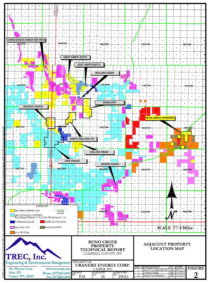
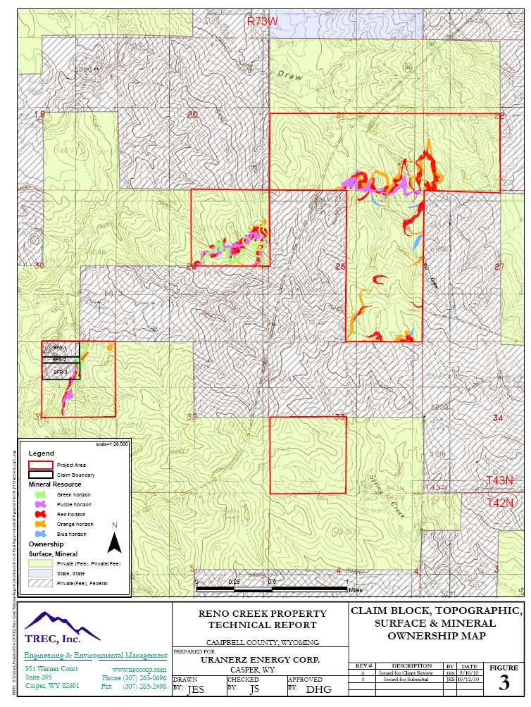

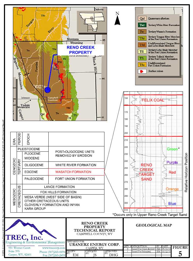


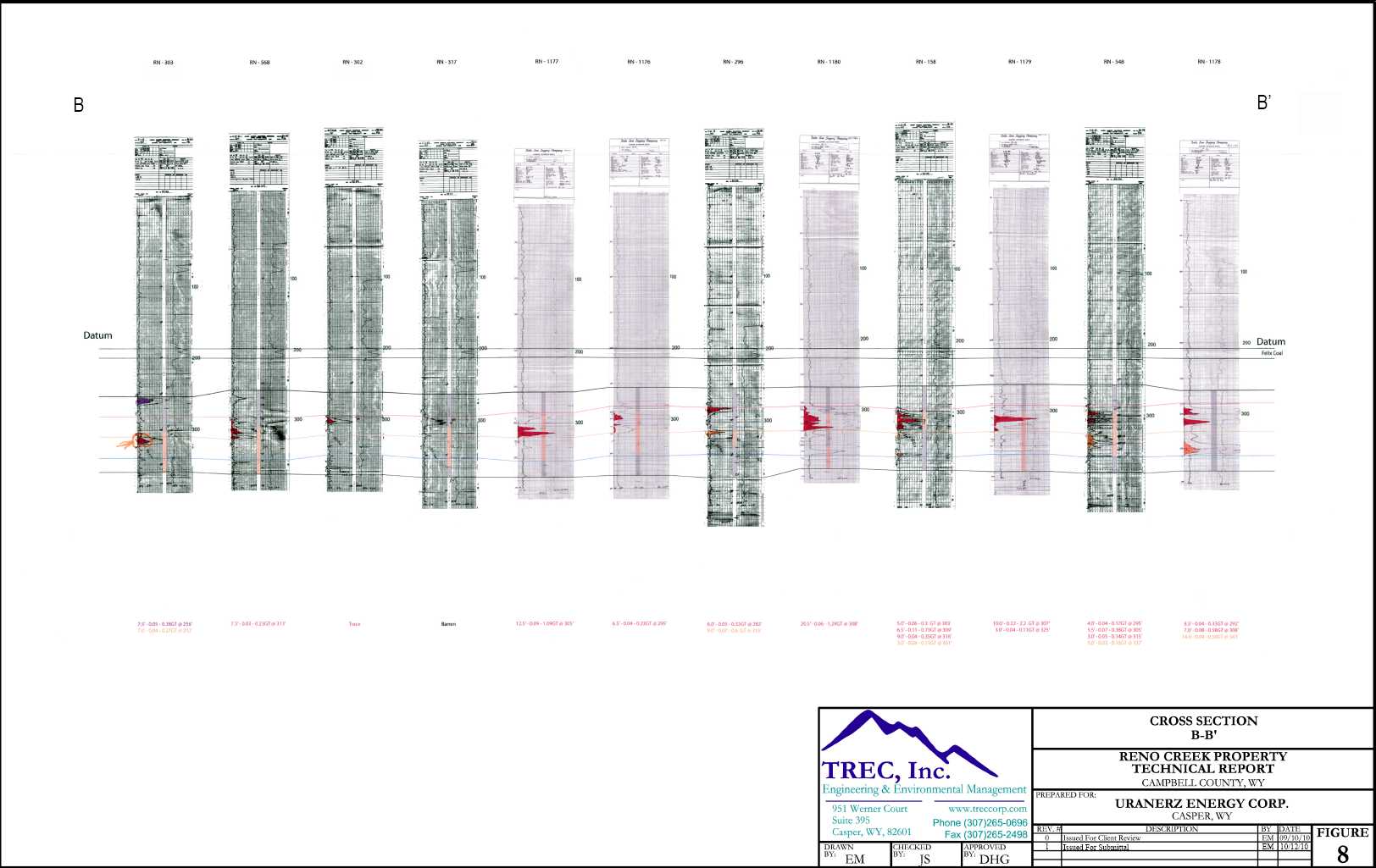
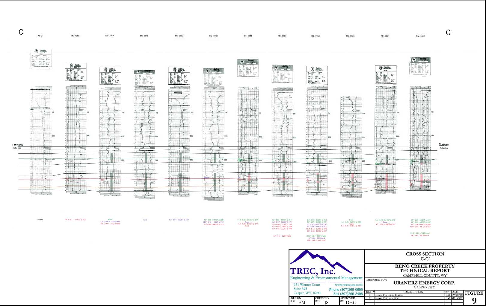
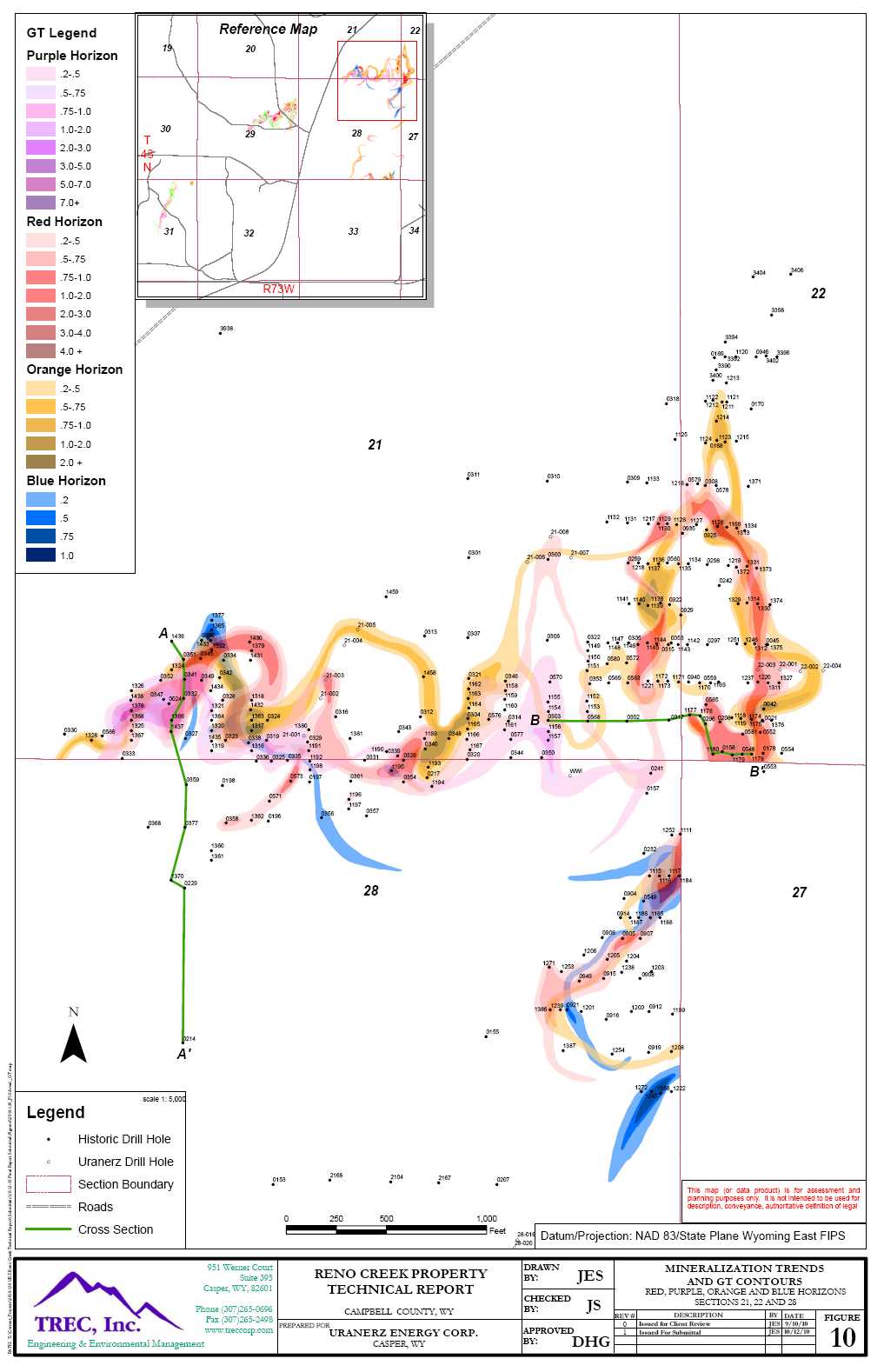
![]()
