Attached files
| file | filename |
|---|---|
| 8-K - 8-K - URANERZ ENERGY CORP. | d69522e8vk.htm |
| EX-99.2 - EX-99.2 - URANERZ ENERGY CORP. | d69522exv99w2.htm |
Exhibit 99.1
Technical Report
South Doughstick Property
Campbell and Johnson Counties, Wyoming, U.S.A.
South Doughstick Property
Campbell and Johnson Counties, Wyoming, U.S.A.
| NI 43-101 Technical Report | ||
| Prepared for: | ||
| Uranerz Energy Corporation | ||
| 1701 East “E” Street | ||
| P.O. Box 50850 | ||
| Casper, WY 82605 |
Prepared by:
Douglass, H. Graves, P.E.
TREC, Inc.
951 Werner Court
Suite 395
Casper, WY 82601
951 Werner Court
Suite 395
Casper, WY 82601
August 11, 2009
Amended and Restated
October 12, 2009
Amended and Restated
October 12, 2009

| South Doughstick Property Technical Report | Page 2 |
| TABLE OF CONTENTS | ||||
| SECTION | PAGE |
1. TITLE PAGE |
1 | |||
2. TABLE OF CONTENTS |
2 | |||
3. SUMMARY |
4 | |||
4. INTRODUCTION AND TERMS OF REFERENCE |
6 | |||
4.1 Report Preparation |
6 | |||
4.2 Property Ownership |
7 | |||
4.3 Purpose of Report |
7 | |||
4.4 Terms of Reference |
7 | |||
4.5 Sources of Information and Data |
7 | |||
4.6 Extent of Author’s Field Involvement |
8 | |||
5. RELIANCE ON OTHER EXPERTS |
8 | |||
6. PROPERTY DESCRIPTION AND LOCATION |
9 | |||
6.1 Location and Size |
9 | |||
6.2 Mining Claims and Surface Use Agreements |
9 | |||
6.3 Legal Surveys |
9 | |||
6.4 Mineralized Areas and Existing Mine Workings |
10 | |||
6.5 Royalties and Encumbrances |
10 | |||
6.6 Environmental Liabilities |
10 | |||
6.7 Required Permits |
10 | |||
7. ACCESSIBILITY, CLIMATE, LOCAL RESOURCES, INFRASTRUCTURE AND PHYSIOGRAPHY |
11 | |||
7.1 Topography, Elevation and Vegetation |
11 | |||
7.2 Access |
12 | |||
7.3 Proximity to Population Centers and Transport |
12 | |||
7.4 Climate |
12 | |||
7.5 Local Resources and Property Infrastructure |
12 | |||
8. HISTORY |
13 | |||
8.1 Ownership History of the South Doughstick Property |
13 | |||
8.2 Exploration and Development Work Undertaken |
13 | |||
8.3 Existing Mineral Resource Estimates and Their Reliability |
14 | |||
8.4 Production History |
14 | |||
9. GEOLOGIC SETTING |
14 | |||
9.1 Regional, Local, and Property Geology |
14 | |||
9.2 Hydrogeology |
15 | |||
10. DEPOSIT TYPES |
16 | |||
11. MINERALIZATION |
17 | |||
12. EXPLORATION |
18 | |||
13. DRILLING |
18 | |||
14. SAMPLE METHOD AND APPROACH |
19 | |||
15. SAMPLE PREPARATION, ANALYSES AND SECURITY |
20 | |||
16. DATA VERIFICATION |
20 | |||
17. ADJACENT PROPERTIES |
20 | |||
18. MINERAL PROCESSING AND METALLURGICAL TESTING |
22 | |||
19. MINERAL RESOURCE AND MINERAL RESERVES ESTIMATES |
23 |
| South Doughstick Property Technical Report | Page 3 |
| SECTION | PAGE |
19.1 Estimate Classification |
23 | |||
19.2 Qualified Persons |
23 | |||
19.3 Quantity and Grade |
23 | |||
19.4 Assumptions and Methods |
25 | |||
19.5 Additional Considerations That Could Materially Affect Mineral Resources 2 |
26 | |||
19.6 No Economic Analyses |
26 | |||
20. OTHER RELEVANT DATA AND INFORMATION |
26 | |||
21. INTERPRETATIONS AND CONCLUSIONS |
27 | |||
22. RECOMMENDATIONS |
27 | |||
23. REFERENCES |
28 | |||
24. DATE AND SIGNATURE PAGE — CERTIFICATION |
30 | |||
25. ILLUSTRATIONS |
32 | |||
LIST OF FIGURES |
||||
Figure 1 General Location Map |
||||
Figure 2 Adjacent Property Location Map |
||||
Figure 3 Claim Block, Topographic, Surface and Mineral Ownership Map |
||||
Figure 4 Drainage Basins Location Map |
||||
Figure 5 Geological Map |
||||
Figure 6 Roll Front Deposit Conceptual Model |
||||
Figure 7 Cross Section A-A’ |
||||
Figure 8 Mineralization Trends and GT Contours |
||||
LIST OF TABLES |
||||
Table 17-1 Adjacent Properties in Pumpkin Buttes Mining District |
||||
Table 17-2 Adjacent Property Estimates of In-Place Tonnage and Grade |
||||
Table 19-1 Mineral Resources Summary |
| South Doughstick Property Technical Report | Page 4 |
3. SUMMARY
This technical report (“Technical Report”) was prepared by Douglass Graves, P.E. of TREC, Inc. The
Author was retained by Arkose Mining Venture (“Arkose”), of which Uranerz Energy Corporation
(“Uranerz”) is an eighty-one percent joint venture partner (see 4.2 Property Ownership), to prepare
an independent technical report in Form 43-101F1 of the Canadian Securities Administrators’
National Instrument 43-101 – Standards of Disclosure for Mineral Projects (NI 43-101) for the
property comprising the South Doughstick area located in Campbell and Johnson Counties, Wyoming,
U.S.A. The Author is an independent “qualified person” as defined by NI 43-101.
This
Technical Report has been amended and restated in order to revise the
mineral resource estimate originally presented in the “South Doughstick Property Technical Report, dated
August 11, 2009. The amendment and restatement is being made as
a result of a recent finding by the Issuer that Arkose does not have control over 100 percent of the fee mineral for the west half of
Section 29. In fact, Arkose has a 50 percent interest for the uranium minerals in the west half of
Section 29. The resource estimate in the August 11, 2009 report
had been prepared on the basis that Arkose had control over 100
percent of the uranium minerals in the west half of Section 29. Since Arkose does not have control over 100 percent of the resource in this area, the
mineral resource estimate has been amended and restated. This has resulted in a decrease of the
mineral resource estimate of 157,481 pounds of measured resource, 257,445 pounds of indicated
resource and 26,987 pounds of inferred resource. As of the date of
this report, Arkose plans to proceed with the negotiation of a fee lease agreement with the owner for the remaining 50
percent interest, although there is no assurance that an agreement
will be concluded.
This Technical Report addresses the uranium mineralization of Arkose’ South Doughstick Property
area which is located in the Pumpkin Buttes region of the Powder River Basin in the state of
Wyoming, as seen in Figure 1. The South Doughstick Property is located within Campbell and Johnson
Counties, Wyoming in Township 43N, Range 76W, Sections 19, 20, 29, 30, 31 and 32 of the
6th Prime Meridian. Within the report area, which is outlined by the general boundary
illustrated in Figure 1, Arkose has 93 unpatented lode mining claims,
fifteen fee mineral leases, an overriding royalty interest and two Surface Use Agreements (SUA). The South Doughstick Property claims and fee leases
encompass approximately 1,896 acres. (See Figures 2 and 3).
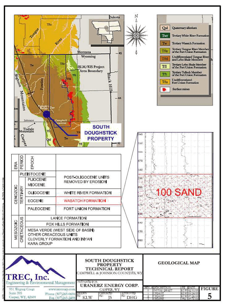
The host for uranium mineralization within the South Doughstick property is the 100 Sand member of
the Eocene Wasatch Formation. The 100 Sand is up to 95 feet thick, and averages 60 feet in
thickness in the South Doughstick Property area. The 100 Sand is equivalent to the A Sand noted
within other properties in the Pumpkin Buttes Mining District. Mineralization averages
approximately six feet in thickness, and rarely exceeds 15 feet in a given drill hole. The uranium
mineralization at South Doughstick that occurs in the 100 Sand unit is typical of the Wyoming
roll-front sandstone deposits.
Exploration drilling began in the northern portion of South Doughstick in the late 1960s by
Cleveland Cliffs Iron Co. (“CCI”), however little interest was generated by the completion of some
15 holes from this drilling. Mining claims were first staked in the central part of South
Doughstick by American Nuclear in 1972, and by the late 1970s, American Nuclear had drilled about
20 exploration holes. This drilling found evidence of uranium mineralization but additional
| South Doughstick Property Technical Report | Page 5 |
exploration or delineation drilling was not conducted. In 2007, Uranerz drilled 33 exploration
holes in the northern part of South Doughstick with mixed results. It was not until 2008 when
Arkose drilled on the South Doughstick property in Section 29, that relevant mineralization at the
property was realized. During the latter half of 2008 and first half of 2009, Arkose completed 311
exploratory holes including two core holes at the South Doughstick property. The Arkose exploration
drill holes were spaced approximately 50 feet apart in rows or fences orientated perpendicular to
the mineralization trend. Additional fences were then drilled approximately every 400 feet along
the length of the trend. Significant mineralization was found and is the subject of this report.
Data available for the resource estimate presented in this Technical Report include lithologic and
geophysical logs, mineralization intercept grade calculations, and stratigraphic cross-sections
from the 2008 and 2009 Arkose and 2007 Uranerz drilling described above. The drilling data
demonstrate two mineralized bodies along one general mineralization trend (roll front) in the 100
Sand, with minor mineralization occurring in a subsidiary upper horizon roll front in the 100 Sand.
This Technical Report presents an independent estimate of measured, indicated, and inferred mineral
resources as defined in Section 1.2 of NI 43-101. Mineral resources are not mineral reserves and
do not have demonstrated economic viability. The estimated mineral quantity and grade described in
this NI 43-101 Technical Report are calculated using accepted protocols. Therefore, these
estimates meet the NI 43-101 classification of “measured”, “indicated” or “inferred” mineral
resources as defined by NI 43-101 and the Canadian Institute of Mining, Metallurgy and Petroleum
Definitions Standards incorporated by reference therein.
The mineral resource estimates shown below were calculated using a GT (Grade x Thickness) contour
method. The GT values of the subject sand intervals for each hole were plotted on a drill hole map
and contour lines were drawn along the general mineralization trend. The areas within the GT
contour boundaries were used for calculating resource estimates. The mineral resources are reported
based on GT cutoffs of 0.20 and 0.50. The 0.20 GT cutoff is recommended for reporting purposes and
is presented in the following table. The 0.50 GT cutoff has been used to highlight areas of
highest mineralization.
The current restated estimate of mineral resources for the South Doughstick Property follows:
Mineral Resource Estimates: Measured, Indicated and Inferred
South Doughstick: 100 Sand
Measured Resource
| Average | ||||||
| GT | eU3O8 | Grade | ||||
| Minimum | Pounds | Tons | % eU3O8 | |||
| 0.20 | 563,115 | 233,190 | 0.121 | |||
| 0.50 | 484,654 | 168,121 | 0.144 |
| South Doughstick Property Technical Report | Page 6 |
Indicated Resource
| Average | ||||||
| GT | eU3O8 | Grade | ||||
| Minimum | Pounds | Tons | % eU3O8 | |||
| 0.20 | 1,309,209 | 542,301 | 0.121 | |||
| 0.50 | 1,152,332 | 417,864 | 0.138 |
Measured + Indicated Resource
| Average | ||||||
| GT | eU3O8 | Grade | ||||
| Minimum | Pounds | Tons | % eU3O8 | |||
| 0.20 | 1,872,324 | 775,491 | 0.121 | |||
| 0.50 | 1,636,986 | 585,986 | 0.140 |
Inferred Resource
| Average | ||||||
| GT | eU3O8 | Grade | ||||
| Minimum | Pounds | Tons | % eU3O8 | |||
| 0.20 | 162,318 | 83,313 | 0.097 |
In the opinion of the Author, the South Doughstick Property represents a potentially viable mineral
resource for future development. The Author has the following recommendations for moving the
property towards development:
| • | Conduct additional radiological disequilibrium and bench scale leach testing with additional coring to confirm previous studies. Approximate cost: $100,000 to $200,000. | ||
| • | Conduct hydrologic investigations and studies including pumping tests, determination of current groundwater levels and groundwater quality. Approximate cost: $100,000 to $150,000. | ||
| • | Complete an economic evaluation of the project. Approximate cost: $70,000 to $100,000. | ||
| • | Conduct environmental baseline studies for preparation of state and federal permit/license applications. Approximate cost: $600,000 to $800,000. |
4. INTRODUCTION AND TERMS OF REFERENCE
4.1 Report Preparation
The following Technical Report was prepared by Douglass Graves, P.E. of TREC, Inc. The Author was
retained by the issuer, Arkose Mining Venture (Arkose), to prepare an independent technical report
in Form 43-101F1 of the Canadian Securities Administrators’ National Instrument 43-101 — Standards
of Disclosure for Mineral Projects (NI 43-101) for the South
| South Doughstick Property Technical Report | Page 7 |
Doughstick Property located in
Campbell and Johnson Counties, Wyoming, U.S.A. (see Figures 1 and 2). The Author is an independent
“qualified person” as defined by NI 43-101.
4.2 Property Ownership
On January 15, 2008, Uranerz Energy Corporation (“Uranerz”) acquired an undivided eighty-one
percent interest in what were then referred to as the “NAMMCO mineral properties” from NAMMCO, a
Wyoming partnership. In connection with the acquisition, Uranerz entered into a joint venture
agreement with United Nuclear, LLC, a limited liability company wholly-owned by the NAMMCO Sellers
(“United Nuclear”) pursuant to which Uranerz is the manager of, and operator of, the NAMMCO
properties (of which South Doughstick is one) under a joint venture named the “Arkose Mining
Venture”. United Nuclear will hold (and contribute to) a nineteen percent working interest in the
Arkose Mining Venture.
Uranerz is a “pure play” uranium exploration company based in Casper, Wyoming, U.S.A., incorporated
in Nevada. It is listed on the NYSE Amex Exchange (formerly called the American Stock Exchange)
and the Toronto Stock Exchange (TSX) under the symbol “URZ”. Uranerz is also listed on the
Frankfurt Stock Exchange under the symbol “U9E.” Uranerz’ major activities are focused on its
properties in the Powder River Basin of Wyoming, U.S.A., an area well known for hosting
uranium-mineralized roll fronts that are amenable to in-situ recovery (ISR) mining techniques.
Uranerz controls approximately 124,604 acres, including 90,529 acres held by Arkose, in the Powder
River Basin and has submitted ISR license and mine permit applications for the Nichols Ranch
Uranium In-Situ Recovery Project (the “Nichols Ranch ISR Project”) located north of the South
Doughstick Property.
4.3 Purpose of Report
The purpose of this Technical Report is to review the available data for the South Doughstick
Property and develop an estimate of mineral resources. This Technical Report conforms to NI 43-101
Standards of Disclosure for Mineral Projects.
4.4 Terms of Reference
Units of measurement unless otherwise indicated are feet (ft), miles, acres, pounds avoirdupois
(lbs.), and short tons (2,000 lbs.). Uranium grade is expressed as weight percent
U3O8, the standard market unit. Grade is reported for historical resources
and the mineral resources reported here are percent eU3O8.
eU3O8 refers to an assay or grade of equivalent uranium as determined from a
gamma ray log. ISR refers to in-situ recovery, also termed ISL or in-situ leach.
4.5 Sources of Information and Data
Arkose performed exploratory drilling within the South Doughstick Property during 2008 and
2009, and the results of the drilling program are the primary source of information and data for
this Technical Report. In addition, the grade calculations from the geophysical logs drilled by
Uranerz in 2007 were used to supplement the Arkose data. The data from historical drilling
conducted by CCI and American Nuclear were not included in this report. The findings of this
Technical Report are based upon published and unpublished data including:
| • | Lithologic and geophysical logs, and intercept grade calculations for drilling completed by Arkose in 2008 and 2009; |
| South Doughstick Property Technical Report | Page 8 |
| • | Drill hole location data for 2008-2009 Arkose drilling and 2007 Uranerz drilling; | ||
| • | Mineralization intercept grade calculations derived from 13 of 33 geophysical logs of the 2007 Uranerz drilling; and | ||
| • | Cross sections constructed from geophysical logs of 2008-2009 Arkose drilling, and selected 2007 Uranerz drilling. |
A more detailed summary pertaining to the drilling program for the South Doughstick Property is
provided in Section 12.
In addition, four reports were evaluated to provide additional background information regarding the
geology and potential for economic development of the property. The reports were also used to
assist the Author in the identification and relative position of the host sand (100 Sand) and to
identify the general location of the mineralized trend. These reports include:
| TREC, Inc.’s NI 43-101 compliant report “Technical Report on the Arkose Mining Venture Project” prepared for Uranerz Energy Corp. in February, 2008 (TREC, 2008); | ||
| BRS Inc.’s NI 43-101 compliant report “Nichols Ranch Uranium Project” prepared for Uranerz Energy Corp. in October, 2007 (BRS, 2007); | ||
| Brown, K.’s, NI 43-101 compliant report “Technical Report, Nichols Ranch Property Johnson and Campbell Counties, Wyoming” in June, 2009 (Brown, 2009); | ||
| TREC, Inc.’s NI 43-101 compliant report “Preliminary Assessment, Nichols Ranch Uranium In-Situ Recovery Project” prepared for Uranerz Energy Corp. in July, 2008 (TREC, 2008b); |
4.6 Extent of Author’s Field Involvement
Douglass Graves, P.E. visited the site on November 19, 2008 to tour the South Doughstick Property
Area with Kurt Brown, Vice President of Exploration, Uranerz. The site visit was conducted to
observe the on-going uranium exploration activities being conducted by Arkose in the South
Doughstick area. Mr. Graves subsequently visited the Casper, Wyoming office of Arkose where
relevant data were obtained for development of this mineral resource estimate.
5. RELIANCE ON OTHER EXPERTS
The information, conclusions, opinions, and estimates contained herein are based on:
| • | Information available to TREC Inc. at the time of preparation of this Technical Report as provided by Bruce Larson (Arkose), and Kurt Brown (Uranerz) . | ||
| • | Assumptions, conditions, and qualifications as set forth in this Technical Report; | ||
| • | Data, reports, and other information supplied by Arkose and third party sources (to the extent identified and as referenced herein). |
For this Technical Report, the Author has relied on property ownership information provided by
Arkose and has not researched property title or mineral rights for the South Doughstick Property.
| South Doughstick Property Technical Report | Page 9 |
The Author expresses no legal opinion as to the ownership status of the South Doughstick Property.
6. PROPERTY DESCRIPTION AND LOCATION
6.1 Location and Size
The South Doughstick Property is located in the Pumpkin Buttes region of the Powder River Basin, in
Campbell and Johnson Counties, Wyoming at a latitude and longitude of approximately 43 degrees, 41
minutes North by 106 degrees, 01 minutes West which is located within Sections 20 29, 30, 31 and 32
of T43N R76W. The primary mineralization is located within Sections 20 and 29 of T43N, R76W. The
property (in road miles) is approximately 43 miles east of Kaycee, 71 miles southwest of Gillette,
and 79 miles north northeast of Casper, Wyoming. See Figure 1.
The South Doughstick area is located in Sections 19, 20, 29, 30, 31 and 32, T43N, R76W of the
6th Prime Meridian, Campbell and Johnson Counties, Wyoming in the Powder River Basin.
For reference purposes, a normal township consists of 36 sections with each section being one
square mile, or six sections by six sections or approximately 36 square miles.
6.2 Mining Claims and Surface Use Agreements
Within the
report area, Arkose has 93 unpatented lode mining claims, fifteen fee
mineral leases, an overriding royalty interest and two Surface Use Agreements (SUA). The South Doughstick Property claims and fee leases
encompass approximately 1,896 acres.
Arkose has control (via a fee mineral lease) of one half of the interest in the fee mineral for the
west half of Section 29. The mineral resource estimate presented herein accounts for this half
interest.
Arkose title to the unpatented lode mining claims is subject to the rights of pedis possessio
against all third party claimants as long as said claims are maintained. The claims do not have an
expiration date. However, affidavits must be filed annually with the federal U.S. Bureau of Land
Management (BLM) and respective county recorder’s offices in order to maintain the claims’
validity. In addition, most of the above-mentioned unpatented lode mining claims are located on
Stock Raising Homestead land where the U.S. government has issued a patent for the surface to an
individual and reserved the minerals to the U.S. government subject to the location rights by
claimants as set forth in the 1872 Mining Law.
The mineral fee leases have terms of 10 years as do the two SUAs. The two SUAs have set provisions
for reimbursement to the surface owner for damages resulting from Arkose operations.
6.3 Legal Surveys
Legal surveys of unpatented lode mining claims are not required, and, to the Authors’ knowledge,
have not been completed to advance the subject property towards patent. The area covered by the
SUAs are based on the legal subdivision descriptions as set forth by the U.S. Cadastral Survey and,
to the Authors’ knowledge, the area covered by the SUAs has not been verified by legal survey.
| South Doughstick Property Technical Report | Page 10 |
6.4 Mineralized Areas and Existing Mine Workings
Mineral resources are located in the Eocene age Wasatch Formation in what is identified as the 100
host sand unit. There are no pre-existing mineral processing facilities or related tailings ponds
or waste deposits within the subject property. There is currently an exploration drilling permit
in effect for the South Doughstick Property (See additional information in Section 6.7). The
proposed Nichols Ranch ISR Project (mining permits applied for from the Wyoming Department of
Environmental Quality and the U.S. Nuclear Regulatory Commission) is located 1.5 miles north of the
South Doughstick Area.
6.5 Royalties and Encumbrances
Lode mining claims in the South Doughstick area are subject to royalties. In Section 20 and the
northeast corner of Section 29, 22 unpatented lode mining claims have a royalty interest burden of
six or eight percent depending on the price of uranium. Surface owners have extraction fees on
production from the claims or mineral fee leases with a burden of one or two percent depending on
the price of uranium. The mineral fee leases have royalty interest burdens ranging from four (4)
to ten (10) percent with some royalty percentages being fixed and some based on the price of
uranium.
The unpatented lode mining claims will remain the property of Arkose provided they adhere to
required filing and annual payment requirements with Johnson and Campbell Counties and the BLM.
The SUAs will remain in force so long as the mining claims are maintained. Legal surveys of
unpatented lode mining claims are not required and are not known to have been completed.
All of the unpatented lode mining claims have annual filing requirements ($140 per claim) with the
BLM, to be paid on or before September 1 of each year.
6.6 Environmental Liabilities
The Author is not aware of any environmental assessments having been performed to identify
potential environmental issues at the subject property. As such, the Author is not aware of any
outstanding environmental issues or liabilities. The only activities that have occurred on the
subject property are exploration drilling for uranium, exploration for oil and gas, and production
of coal bed methane (“CBM”) gas. Arkose’s only known existing potential liability is restoration
of exploration drill sites and exploration access roads.
6.7 Required Permits
Exploration
Exploration drilling has been conducted at the South Doughstick Property. The volume and
extent of exploration is described in detail in Sections 8.1 and 8.2. Additional exploratory
drilling may be conducted by Arkose to better define mineralization within specified areas of
interest. Arkose has a Notification to Drill permit from the State of Wyoming Department of
Environmental Quality/ Land Quality Division (“WDEQ/LQD”) for all exploration drilling.
Production
Future mining development will require a number of licenses/permits with the two most
| South Doughstick Property Technical Report | Page 11 |
significant being (a) the Permit to Mine, issued by the WDEQ/LQD and (b) the Source Material
License, required and issued by the U.S. Nuclear Regulatory Commission (“NRC”) for mineral
processing of natural uranium. In December 2007, Uranerz (81% owner of Arkose) submitted permit
applications for the Permit to Mine and for the Source Material License to the WDEQ/LQD and NRC,
respectively for the Nichol Ranch ISR Project (100% owned by Uranerz) located north of the
Property. These applications are currently being reviewed by the regulatory oversight agencies.
The applications include identification of a central processing plant, satellite plant and well
fields to be located north of the South Doughstick Property.
The NRC has the responsibility to issue Source Material Licenses to “receive title to, receive,
possess, use, transfer, or deliver any source material after removal from its place of deposit in
nature” (Code of Federal Regulations (“CFR”) 40.1 and 40.3). “Source nuclear material” is defined
as uranium and/or thorium in any form, or ores containing 0.05 percent or more by weight uranium
and/or thorium. The NRC is responsible for the oversight and implementation of the National
Environmental Policy Act (“NEPA”) regulations. Pursuant to 10 CFR 51.20, all licenses for new
uranium mills (including ISR facilities) will be required to submit a license application that will
include an environmental report and a technical report. 10 CFR 51.20 further requires that an
Environmental Impact Statement (EIS) be conducted for new uranium mills (including ISR facilities).
In June 2009, NRC issued a Generic Environmental Impact Statement (“GEIS”) for new uranium ISR
operations to meet this requirement. Additional site specific environmental reviews will be
conducted at each new site resulting in a supplemental EIS that is tiered off of the GEIS.
Environmental baseline information (hydrology, vegetation, wildlife, etc.) on this property would
be developed in order to complete the applications for a WDEQ/LQD Permit to Mine and a NRC Source
Material License.
Any injection or pumping operations will require permits from the WDEQ which has authority under
the Safe Water Drinking Act that stems from a grant of primacy from the U.S. Environmental
Protection Agency for administering underground injection control programs in Wyoming.
7. ACCESSIBILITY, CLIMATE, LOCAL RESOURCES, INFRASTRUCTURE AND PHYSIOGRAPHY
7.1 Topography, Elevation and Vegetation
The South Doughstick Property is located within the Wyoming Basin physiographic province, in the
Central portion of the Powder River Basin, within the Pumpkin Buttes Mining District. The Pumpkin
Buttes are a series of small buttes rising up to nearly 6,000 feet elevation, and approximately
1,000 feet above the surrounding plains. The rock capping the top of the buttes is the Oligocene
age White River Formation erosional remnant, which is believed to have overlain the majority of the
Powder River Basin. While the volcanic tuffs in the White River Formation have been cited as a
possible source of uranium in this basin (Davis, 1969), the White River itself is not considered a
uranium resource in this area. The South Doughstick Property is located eight air miles west of the
South Pumpkin Butte.
The South Doughstick Property area consists of sagebrush and native grasses, covering rolling
hills, steep walled gullies, and ephemeral streams. Elevations range from approximately 4,750 to
4,950 feet above sea level. Figures 1 and 3 illustrate the topography of the subject property.
The South Doughstick Property is located in the Cottonwood Creek and Seventeenmile Creek
| South Doughstick Property Technical Report | Page 12 |
drainages roughly 15 miles southeast of the confluence with the Powder River. Cottonwood Creek and
Seventeenmile Creek are a tributary to the Dry Fork of the Powder River, which is a tributary to
the Powder River.
Historically and currently, the land is used for livestock and wildlife grazing. Vegetation is
characteristically sagebrush shrub land and mixed grassland with some pines on elevated terrain and
some deciduous trees within drainages.
7.2 Access
The South Doughstick property is accessible via two-wheel drive on existing private gravel and dirt
roads many of which have been improved by CBM development. The approximate center of the subject
property is approximately eight air miles north of Wyoming Highway 387 (see Figure 2). Some road
development and improvements may be required at a later time to facilitate future development of
wellfields or satellite facilities.
7.3 Proximity to Population Centers and Transport
The South Doughstick Property is located approximately 71 road miles southwest of Gillette, Wyoming
and 79 road miles northeast of Casper, Wyoming. The project is accessed from Wyoming Highway 387
from the south and secondary county gravel surface and light-duty to unimproved private roads. The
site location is shown on Figures 1 and 2.
7.4 Climate
In the vicinity of the South Doughstick Property, the weather may limit the time periods for
capital construction but should not significantly affect the operation of an ISR facility. The
climate is semiarid and receives an annual precipitation of approximately 13 inches, the majority
of which falls from February to April as snow. Cold, wind, and snow/blizzards can make winter
exploration and construction work in this area difficult but not impossible. The summer months are
typically hot, dry and clear except for infrequent high-intensity, short-duration storm events.
7.5 Local Resources and Property Infrastructure
As discussed in Section 6.0, Arkose has secured sufficient surface access rights for exploration
and development of the project.
The basic infrastructure (power, water, and transportation) necessary to support an ISR mining
operation is located within reasonable proximity of the subject property. Existing infrastructure
is associated with local oil, gas, and CBM development. Based upon discussions with the local
electrical service provider, overhead power is currently committed, but additional power for future
projects can be made available.
Non-potable water will be supplied by wells developed at or near the site. Water extracted as part
of ISR operations will be recycled for reinjection. Typical ISR mining operations also require a
disposal well for limited quantities of fluids that cannot be returned to the production aquifers.
A deep disposal well is planned for the Nichols Ranch ISR Project processing facility immediately
north of the South Doughstick Property.
The proximity of the South Doughstick Property to paved roads will facilitate transportation of
equipment, supplies, personnel, and product to and from the property.
Although the population within 50 miles of the subject property consists mainly of rural ranch
| South Doughstick Property Technical Report | Page 13 |
residences, personnel required for exploration, construction, and operation are available in the
nearby towns of Wright, Midwest, Edgerton, Gillette, Buffalo, and Casper, Wyoming.
Tailings storage areas, waste disposal areas, heap leach pad(s) will not be a part of the
infrastructure for the South Doughstick Property, as ISR operations do not require these types of
facilities. However, solutions from mining South Doughstick may be sent by pipeline to the
proposed Nichols Ranch ISR Project processing facility or a satellite plant may be constructed,
once approved by a Source Material License and Permit to Mine, applications for which have not yet
been submitted for South Doughstick.
8. HISTORY
8.1 Ownership History of the South Doughstick Property
The South Doughstick Property is located within a large exploration area encompassing Townships 33
through 50 North of Ranges 69 through 79 West, on the 6th principal meridian. In 1966, Mountain
West Mines Inc. (“MWM”, now Excalibur Industries) began a successful drilling exploration program
in a portion of the larger area. In 1967, MWM entered into an agreement with CCI for further
exploration and option if suitable resources were found. CCI exercised its option in 1976 with
plans to begin underground mining operations in the vicinity of North Butte. Changing economic
conditions and the development of ISR mining technology reportedly ended much of CCI’s interest in
the area.
In addition to CCI, other uranium exploration companies during the last forty years have controlled
property either within or near the South Doughstick Property. These included Kerr McGee, Conoco,
Texaco, American Nuclear, Tennessee Valley Authority, Rio Algom, and Uranerz U.S.A., Inc. The
mining claims and leases originally controlled by most of these companies were let go over the
years due to market conditions. These property abandonments continued into 2004.
Acquisition of mineral rights to the Arkose properties, including South Doughstick, commenced in
2005 by NAMMCO (now United Nuclear, LLC) and continued into 2006 and 2007. On January 15, 2008,
Uranerz completed acquisition of an undivided eighty-one percent interest in the NAMMCO properties
(of which South Doughstick is one) and formed the Arkose Mining Venture with United Nuclear, LLC
for the purpose of exploring and developing the properties.
8.2 Exploration and Development Work Undertaken
Exploration drilling began in the northern portion of South Doughstick, Section 20, T43N, R76W,
between the late 1960s and early 1970s by CCI. Little interest was generated by the completion of
some 15 holes from this drilling. According to records, mining claims were first staked in the
central part of South Doughstick by American Nuclear in 1972. By the late 1970s, American Nuclear
drilled about 20 exploration holes in Section 29, T43N, R76W. This drilling found evidence of
uranium mineralization but additional exploration or delineation drilling was not conducted. In
2007, Uranerz drilled 33 exploration holes across the northern and southern part of Section 20 with
mixed results. It was not until 2008 when Arkose drilled on the South Doughstick Property in
Section 29, that the potential for the property was realized. During the latter half of 2008,
Arkose completed 204 exploratory holes including two core holes, and during the first half of 2009,
Arkose completed an additional 107 exploration drill holes for a total of 311 holes. Significant
mineralization was found and is the subject of this report.
| South Doughstick Property Technical Report | Page 14 |
8.3 Existing Mineral Resource Estimates and Their Reliability
There are no published or unpublished mineral resource reports that cover the South Doughstick
Property. There is one unpublished and two published reports on the Nichols Ranch ISR Project
located 1.5 miles north of the subject property and a published report covering the potential for
mineralization on the Arkose properties as a whole (including South Doughstick). The Author
reviewed the four reports identified in Section 4.4, Brown 2009, BRS 2007, TREC 2008 and TREC
2008b. These documents are considered by the Author to be relevant to this report. All four
reports are published and are NI 43-101 compliant. These reports provide background information
and confirmation of the geology and potential for economic development. The reports were also used
to assist the Author in the identification and relative position of the host sand (100 Sand
equivalent to A Sand identified in these other reports) and to identify the general location of the
mineralized trend (roll front).
8.4 Production History
The South Doughstick Property is located within the Pumpkin Buttes Mining District, which was the
first commercial uranium production district in Wyoming. Uranium was first discovered in the
Pumpkin Buttes in 1951. Intermittent production from some 55 small mines through 1967 produced
36,737 tons of ore containing 208,143 pounds of uranium (Breckenridge et al., 1974). This early
mining focused on shallow oxidized ores exploited by small open-pit mines. The ore was generally
transported to the Atomic Energy Commission buying station in Edgemont, South Dakota. Modern
mining in the district has focused on deeper reduced ores.
The Author did not identify any known uranium production from the South Doughstick Property.
However, there has been production in close proximity. Prior ISR tests and operating uranium
production near the subject property include the Christensen Ranch commercial ISR mine, controlled
by AREVA located nine miles north of South Doughstick; the Collins Draw and North Rolling Pin pilot
tests located four miles east and northeast of the South Doughstick area; and the Ruth pilot test
located five miles southwest of South Doughstick which produced 32,000 pounds of
U3O8. The Christensen Ranch ISR facility has produced millions of pounds of
U3O8 and is currently on stand-by status. Figure 2 illustrates the location
of these projects.
9. GEOLOGIC SETTING
9.1 Regional, Local, and Property Geology
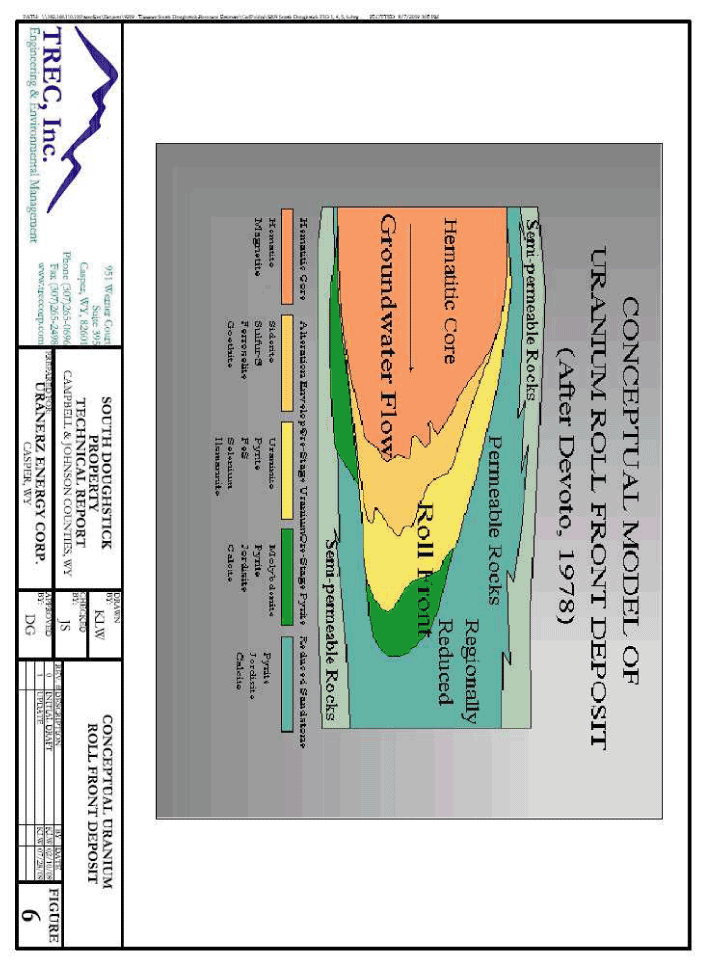
Regional, local and property surficial geology is shown on Figure 5. Figure 6 provides a
conceptual model of the uranium roll front deposit within South Doughstick.
The Eocene age Wasatch Formation hosts the uranium mineralization within and adjacent to the South
Doughstick Property. The Wasatch is a fluvial deposit composed of sandstones interbedded with
claystones, siltstones, carbonaceous shale, and thin coal seams. The sandstones compose roughly
one-third of the sequence and tend to be lenticular and laterally discontinuous. The finer
claystone – siltstone layers are more laterally continuous. In the vicinity of the Pumpkin Buttes,
the Wasatch Formation is reportedly 1,575 feet thick (Sharp and Gibbons, 1964).
Underlying the Wasatch is the Paleocene age Fort Union Formation, another fluvial sedimentary
| South Doughstick Property Technical Report | Page 15 |
deposit consisting of coals, sandstones, siltstones, and claystones. Over most of the Powder River
Basin, the coals in the upper portion of the Fort Union are separated from sands in the overlying
Wasatch Formation by at least 300 feet of continuous, low-permeability claystone and siltstone
units of variable thickness, separating the proposed uranium mining from existing CBM production
horizons at South Doughstick. The total thickness of the Fort Union in this area is reportedly
3,000 feet.
The mineralized zones at the South Doughstick Property are typical Powder River Basin roll-front
deposits. Uranium mineralization, where present, is found at the interface of naturally occurring
chemical boundary between reduced and oxidized sandstone facies. Due to the nature of fluvial
sandstone composition, an individual sand member may have several vertically superimposed
subsidiary roll fronts. This is caused by small permeability differences in the sandstone or the
occasional vertical contact between sand members resulting in development of multiple roll fronts
that overlie each other in complex patterns.
The stratigraphy of the Wasatch consists of alternating layers of sand and shale with lignite
marker beds. At the South Doughstick Property, there are four primary groups of Wasatch Formation
sand members (150, 140, 110/120/130, and 100 Sands). The 150 Sand member (equivalent to the F Sand
in the region) is the shallowest, occurring at or near the surface in the area, and the 100 Sand
member is the deepest. These Wasatch sand members are not all present throughout the South
Doughstick area, due the fluvial origin of deposition.
The area in which the South Doughstick Property lies is in close proximity to the synclinal axis of
the Powder River Basin, and the host Wasatch Formation dips approximately 2 to 3 degrees to the
northeast in this area.
At the South Doughstick Property, the mineralized sand horizon (100 Sand) occurs within the lower
part of the Wasatch at an approximate depth from surface ranging from 365 to 663 feet and averaging
560 feet to the top of the mineralization. The host sand is primarily arkosic in composition,
friable, and contains trace carbonaceous material and organic debris. There are local sandy
mudstone/siltstone intervals with the sandstone, and the sand may thicken or pinch-out in some
locations.
9.2 Hydrogeology
The South Doughstick Property is located within the Powder River Drainage Basin. The area is of
moderate topographic relief (elevations range from 4,750 to 4,950 feet above sea level) with
ephemeral surface water drainages to the Powder River to the west. South Doughstick is located in
the Cottonwood Creek and Seventeenmile Creek drainages roughly 15 miles southeast of the confluence
with the Powder River. Cottonwood Creek and Seventeenmile Creek are a tributary to the Dry Fork of
the Powder River, which is a tributary to the Powder River.
Recharge to the sands of the Wasatch is mainly on their outcrops. Flow in the aquifers generally
moves to the north along the paleodrainage trends, with a small portion of the groundwater
discharging to streams. Aquifer properties are locally unpredictable due to large variations in
local lithologies. Transmissivities within the Wasatch are known to range anywhere from 1 to 5,000
gpd/ft.
According to the Wyoming State Engineer’s Office, there are 10 permitted stock water wells and
| South Doughstick Property Technical Report | Page 16 |
no domestic water wells in or near the South Doughstick area. Two of the stock water wells report
static water depths and include:
| • | Fetty Well No. 1 is located in the SW/SW of Section 21, T43N, R76W, just east of the South Doughstick claim blocks in Section 20. The reported static water level is 135 feet below surface. | ||
| • | Taylor #22-1 Well is located south of the area in SE/SW of Section 32, T43N, R76W. The reported static water depth is 60 feet below surface. |
The limited static water level information suggests that water levels at South Doughstick will not
negatively impact the suitability of ISR mining, as the average mineralized zone depth is 560 feet,
significantly below the water levels of 60 to 135 feet below surface. However, the acquisition of
additional hydrologic data is needed to confirm water levels within the area.
Generally, the host 100 Sand aquifer is confined from the 110/120/130 Sand aquifers by the aquitard
which overlies the 100 Sand at the South Doughstick Property. However, there are occasional areas
of thinning or lack of presence of the confining layer that overlies the 100 Sand. In those areas
where the confining layer has marginal thickness or is not present, it may be necessary to include
the 110/120/130 Sand aquifers as part of the mining zone aquifer. A hydrologic study, including
aquifer pump tests, will be needed to evaluate the situation and adjust the mine and aquifer
restoration plans accordingly.
Recommendations in this Technical Report include hydrologic investigations and studies including
pumping tests and collection of ground water level data and quality.
10. DEPOSIT TYPES
Uranium mineralization at the South Doughstick Property is typical of the Wyoming roll-front
sandstone deposits as described by Granger and Warren (1979), Rackley (1972), and Davis (1969).
Sandstone-type deposits are irregular in shape, roughly tabular and elongate, and range from thin
pods a few feet in width and length, to bodies several tens or hundreds of feet in length. The
deposits are roughly parallel to the enclosing channels but may form rolls that cut across bedding.
Roll-front deposits generally occur along a geochemical front and are typified by a C-shaped
morphology in which the outside of the “C” extends down-gradient (direction of historical
groundwater flow), and the tails of the “C” extend up-gradient. The tails are typically caught up
in the finer sand deposits that grade into the over- and underlying mudstones, whereas the heart of
the roll-front (ore-grade mineralization) lies within the more permeable and porous sandstones
toward the middle of the fluvial channels. Figure 6 shows a conceptual model of a typical roll
front. The uranium deposits at the South Doughstick Property generally do not outcrop at the
surface, thus the exploration program requires drilling for discovery and to make grade/thickness
determinations based on drill cuttings samples and geophysical log signature. Once the initial
trend of the geochemical front is established, subsequent exploratory drilling continues along the
trend utilizing a series of bore hole “fences” drilled normal to the front at pre-determined
distances between fences. Critical information derived from the results of the exploratory
drilling including mineralization and roll-front trends, the nature and distribution of the uranium
deposits, host sandstone body characteristics, and other geologic data which are utilized for
describing the potential deposit.
| South Doughstick Property Technical Report | Page 17 |
11. MINERALIZATION
Mineral resources in the South Doughstick Property occur within sand bodies of the Eocene age
Wasatch Formation in what is identified as the 100 Sand host unit. Two general bodies of
mineralization occur within the 100 Sand along one general trend (roll front). One ore body lies
in the northern portion of the area, occurring primarily in Section 20 of T43N, R76W, and one body
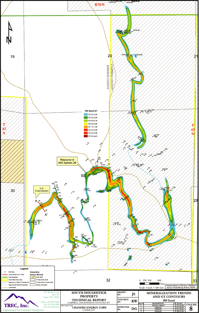
in the southern part of the area lying mostly in Section 29 of T43N, R76W. Figure 8 illustrates
the two mineralized bodies found at South Doughstick. It should be noted that minimal amounts of
mineralization were detected in two drill holes in the 120 and 140 Sands of the Wasatch Formation,
which lie stratigraphicaly above the 100 Sand. However the mineralization noted in these sands was
insufficient in grade, thickness and area to be considered for inclusion in this mineral resource
estimation.
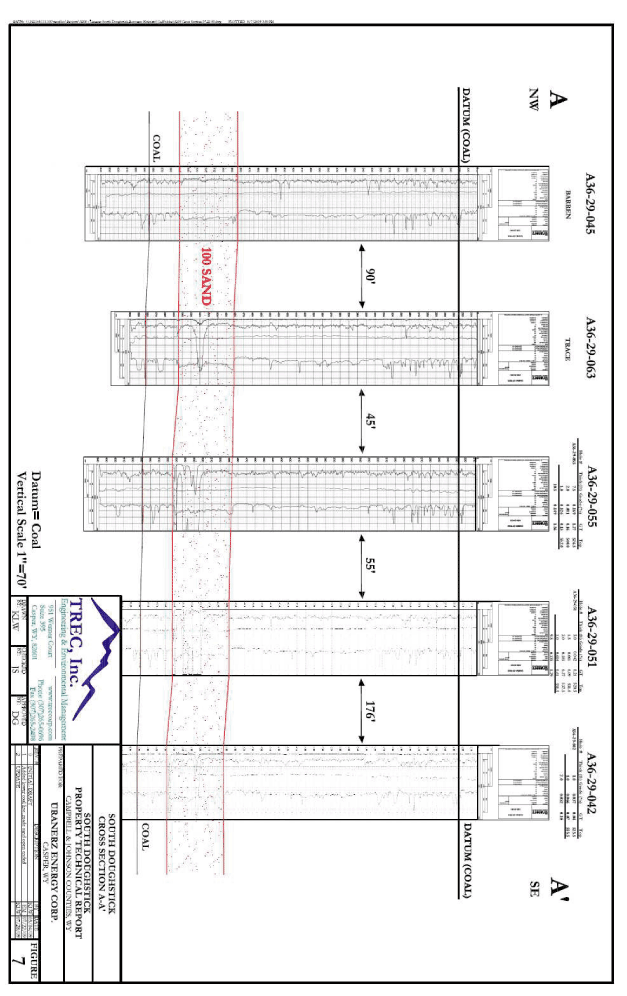
The depth to the top of mineralization for the 100 Sand ranges from 365 feet to 663 feet from
surface, and averages 560 feet in depth. Figure 7 provides a cross section through the mineral
trend in the southern part of the area, and illustrates the relative position of the host 100 Sand
in the South Doughstick Area.
Of the 311 Arkose holes drilled in South Doughstick, 128 had mineralization with a minimum 0.2 GT
cutoff. This mineral resource estimate used data from the 128 Arkose drill holes, including two
cored holes, to determine the grade, thickness, and GT for the stated mineral resource.
Additionally, grade, thickness and GT data from 13 of 33 Uranerz drill holes were used for the
mineral resource estimate in this Technical Report. Two drill holes, located south of the main ore
bodies, were noted to contain anomalously high mineral concentrations within a single one foot
interval, and were thus excluded from the resource estimation. The basic mineralization parameters
follow.
Mineralization Thickness
Mineralized thickness ranges from 1 to 19 feet, with an average mineralization thickness of
approximately 6 feet, for grades greater than 0.03% eU3O8.
Grade
Mineral resource estimates detailed in Section 19.0 below were determined by the GT contour method.
Average grade is dependent upon cutoff assumptions. The average grade of the Measured Resource,
based on eU3O8 (radiometric equivalent weight percent) for GT > 0.20 is
0.122% eU3O8; the average grade of the Indicated Resource is 0.120%
eU3O8. The combined Measured and Indicated Resources average grade is 0.121%
eU3O8. The Inferred average grade at GT cutoff of 0.20 was 0.096%
eU3O8
Trend Length
The mineralization appears to lie in two general ore bodies along a single mineralization trend (as
seen in Figure 8). The two mineral bodies are separated by a region of minimal mineralization, or
barren of mineralization, as defined by drilling along the reduction/oxidation boundary in the 100
Sand. The exploratory drilling completed for the project defines a mineralized trend in the
northern part of the area (Section 20, T43N, R76W) of approximately
| South Doughstick Property Technical Report | Page 18 |
4,600 feet, and of approximately 12,900 feet in length for the southern mineralization trend
(Section 29, T43N, R76W).
Trend Width
Using a minimum GT value of 0.20, the trend width of the ore body in the northern South Doughstick
area ranges from 75 to 200 feet, and averages approximately 130 feet. The ore body located on the
trend in the southern part of South Doughstick varies in width from 50 to 300 feet, and averages
approximately 150 feet.
12. EXPLORATION
As discussed in Section 8.2, Arkose conducted its own exploration program by drilling 204 holes in
the South Doughstick Property area during 2008, followed by an additional 107 holes drilled during
2009. Exploration efforts previous to those of Arkose produced limited data and mixed results.
Data from the current Arkose and Uranerz geophysical and lithological logs are considered reliable
for the purposes of this estimate. The following summarizes the exploration activities that have
occurred at the South Doughstick Property:
| • | 15 exploratory drill holes completed by CCI during the time period between the late 1960s and early 1970s; | ||
| • | 20 exploratory drill holes completed by American Nuclear between 1972 and the late 1970s. This drilling found evidence of uranium mineralization but additional exploration or delineation drilling was not conducted; | ||
| • | 33 exploratory drill holes completed by Uranerz in 2007 in the northern part of South Doughstick with mixed results; | ||
| • | 204 exploratory drill holes completed by Arkose in 2008. Relevant mineralization was realized in Section 29 and additional drilling revealed significant mineralization; | ||
| • | 107 exploratory drill holes completed by Arkose in 2009. Additional significant mineralization was found. |
The results of the Arkose and Uranerz drilling program are the primary source of information used
in this mineral resource report. These data demonstrate that mineralization is present on the
property and the data define the spatial attributes of the mineralization.
The Arkose database also includes the results of two chemical analysis and leach tests performed by
Energy Laboratories, Inc. for Arkose on core from two drill holes.
13. DRILLING
Conventional water based mud drilling methods were used to drill the approximately 379 boreholes
(Arkose and Uranerz plus historical) at South Doughstick. The geophysical and lithologic log data
from the 344 Arkose and Uranerz drill holes were used in the evaluation of the South Doughstick
Property. Of the 344 drill holes, 141 of the holes had mineralization with a GT of 0.2 or greater.
Data from the 141 drill holes, including two cored holes, were used to determine the grade,
thickness, and GT for the stated mineral resource.
Uranium Exploration Drill Holes
| South Doughstick Property Technical Report | Page 19 |
Common practice for uranium exploration drilling is to drill exploration holes vertically using
conventional rotary drill rigs circulating drilling mud and using approximately five-inch diameter
bits. The cuttings are typically collected from five-foot vertical intervals and laid out on the
ground in rows of 20 samples (each row representing 100 feet in boring depth) by the driller. The
site geologist typically examines and documents the cuttings in the field to determine lithology
and geochemical alteration, i.e., oxidized or reduced geochemistry.
Upon completion of the drilling the drill holes are logged, from the bottom of the hole upward,
with a gamma-ray, spontaneous-potential, and resistivity tool by either a contract logging company
or a company-owned logging truck. The locations of the holes are recorded in the field by the site
geologist using a Global Positioning System (GPS) unit.
The South Doughstick Property lies just to the west of the Powder River Basin synclinal axis, and
the host Wasatch Formation dips approximately 2-3 degrees to the northeast. As the drilling was
generally conducted vertically, the relationship between the mineralized thickness interpreted from
logging results and the true thickness of mineralization will have only slight variation, and will
not have an impact on the mineral resource estimate, nor would a slight variation in horizontal
location impact the mineral resource estimate.
In the Author’s opinion, the data collected within the South Doughstick Property have been
collected in a reliable manner consistent with standard industry practices, and the Author has
relied upon these available data to prepare this mineral resource estimate.
CBM and Oil Exploration/Production Well Drilling
Within the area which encompasses the South Doughstick Property there are multiple CBM wells which
include 18 actively producing wells, five active permit wells and two shut in wells according to
the Wyoming Oil and Gas Conservation Commission (“WOGCC”) records (WOGCC, 2009). The CBM wells
range in depth from approximately 1,183 feet to 1,852 feet within the property boundary. The CBM
target beneath the Property is the Big George coal seam, which ranges locally from approximately 70
to 140 feet thick, and averages approximately 750 feet below the uranium mineralization in this
area. As indicated, the CBM production zones are significantly below the anticipated uranium
recovery production zone.
Within the South Doughstick Property boundary there is one plugged and abandoned oil well, located
in the NW/NE of Section 29, T43N, R76W, that was completed as a dry hole to a depth of 10,210 feet.
This well is far below the depth of uranium mineralization in the area.
14. SAMPLE METHOD AND APPROACH
Downhole geophysical logs and grade calculations provided by Arkose were used as the primary source
of data for defining the South Doughstick Property mineralization. As indicated in Section 13.0,
recent exploration included 311 holes that were drilled by Arkose, and 33 by Uranerz in the South
Doughstick area. The Arkose exploration drill holes were spaced approximately 50 feet apart in rows
or fences orientated perpendicular to the mineralization trend. Additional fences were then
drilled approximately every 400 feet along the length of the trend. See Figure 8 for an
illustration of the spacing and density of the exploratory drill holes.
Quality control for coring and field sampling performed by Arkose utilizes training, demonstration
of basic geological abilities by field personnel and management oversight. Exploratory drill hole
cutting samples are recovered in a wet or damp condition and soon after
| South Doughstick Property Technical Report | Page 20 |
they are described by a field geologist. Down hole electric logging is checked against the
driller’s logs and the gamma detection instruments are calibrated in the Casper, Wyoming United
States Department of Energy test pits approximately every 60 days. Records are kept on all these
activities.
Core samples were recovered from two holes cored during the 2008 Arkose drilling for chemical
testing for the purpose of disequilibrium determination and the amenability to ISR techniques. A
discussion of the test results is found in Section 20 of this report.
The data are considered accurate and reliable for the purpose of completing a mineral resource
estimate.
15. SAMPLE PREPARATION, ANALYSES AND SECURITY
The core samples, discussed in Section 14.0, were recovered and handled in the field by trained and
qualified personnel under the supervision of Arkose field staff and management. Laboratory sample
preparation and analysis were conducted by Energy Laboratories, Inc. (“Energy Labs”) in Casper,
Wyoming. Energy Labs is certified by the National Environmental Laboratory Accreditation Program
(“NELAP”). Core samples were prepared and analyzed using Standard Operating Procedures (“SOP”s)
with testing methods and test results checked through a Quality Assurance/Quality Control (“QA/QC”)
program. The laboratory QA/QC program included identification of the proper equipment and
instrumentation for the given analytical method; standards for equipment sequence of operation
including equipment calibration; personnel qualifications and training; analysis and data reporting
of laboratory test control samples, duplicate and method blank samples, and matrix fortified
(spiked) samples to ensure accurate and precise analytical results. The results of the chemical
tests were not used directly for this mineral resource estimate but were used as a basis for the
assumption of equilibrium conditions provided in Section 20 of this report. As previously
discussed in Section 14.0, the data are considered accurate and reliable for the purpose of
completing a mineral resource estimate of the property.
16. DATA VERIFICATION
The mineral resource estimate presented herein was developed based on geophysical data, grade
calculations, lithological logs, and cross sections from 311 exploratory holes drilled by Arkose,
and from grade calculations derived from 33 holes drilled by Uranerz within the South Doughstick
Property area. These data were used to identify the sand host, mineralization depth, and grade and
thickness of mineralization. The grade calculation data were checked for accuracy of depth,
thickness, grade and host sandstone identification and were compared with the geophysical logs.
Each geophysical log header was checked against the data summary sheet to confirm the drill hole
number and location, and the ore grade summaries presented on the geophysical logs were compared
with the data summary sheets, and the data were confirmed. The drill hole locations were plotted
and checked for accuracy by comparison with the original drill hole map, and confirmed. The data
have been verified by the Author to the extent possible and within the limits discussed in Sections
14.0 and 15.0.
17. ADJACENT PROPERTIES
Arkose holds mineral rights to approximately 90,529 acres in the area, including the South
Doughstick Property. A significant amount of property acreage with mineral rights in the
| South Doughstick Property Technical Report | Page 21 |
Pumpkin Buttes Mining District is held by Uranerz. Some of the Uranerz properties are planned for
development (see Figure 2). These lands are within the Mining District and have identified
potential for mineralization in the Wasatch Formation. Some of these properties are within or
adjacent to areas of known mineralization and/or past production. The following table summarizes
land holdings in the vicinity of the South Doughstick Property. It also identifies four additional
properties near the South Doughstick Property that are owned by other operators.
Table 17-1 Adjacent Properties in Pumpkin Buttes Mining District
| Claims | ||||||||||
| and | Approximate | |||||||||
| Property | Ownership | Township | Range | Leases | Acreage | |||||
Doughstick |
Uranerz | T43N | R76W | 22 | 440 | |||||
Arkose Properties |
Arkose Mining Venture | T41- 44N | R74 – 78W | 4,206 +/- | 89,189 net | |||||
Nichols Ranch |
Uranerz | T43N | R76W | 35 | 700 | |||||
Collins Draw |
Uranerz | T42/43N | R76W | 58 | 1,160 | |||||
North Rolling Pin |
Uranerz | T43N | R76W | 65 | 1,300 | |||||
C-Line |
Uranerz | T43N | R75W | 40 | 800 | |||||
Hank |
Uranerz | T43N/44N | R75W | 63 | 2,250 | |||||
West North Butte
Satellite
Properties |
Uranerz | T44N | R76W | 145 | 2,900 | |||||
Verna Ann/Niles Ranch |
Uranerz | T44N | R74/75W | 7 | 140 | |||||
Moore Ranch |
Uranium One | T41/42N | R74/75W | 91 | 3,214 | |||||
North Butte |
Cameco | T44N | R76W | Not Available | Not Available | |||||
Ruth |
Cameco | T42N | R77W | Not Available | Not Available | |||||
Ruby |
Cameco | T43N | R74W | Not Available | Not Available |
| South Doughstick Property Technical Report | Page 22 |
This Technical Report addresses only the South Doughstick Property and not the other adjacent
properties identified in the table above. Existing reports (published and unpublished) for several
of these adjacent properties (Brown 2006, 2006a, 2006b, 2007, 2009; Berglund 2006, 2007, 2007a;
BRS, 2006 2007 and TREC, 2008, 2008a, 2008c) provide estimates of mineral resources.
The following estimates of in-place tonnage and grade presented in the table below are based on
reports and data that were prepared by Uranerz and/or other operators. Independent qualified
person verification under NI 43-101 and CIM standards has not been completed for all of these
estimates. The highlighted estimates are not considered by the Authors to be reliable for use in
mineral resource estimates.
Table 17-2 Adjacent Property Estimates of In-Place Tonnage and Grade
| Avg. Grade | ||||||
| Property | Source | Tons | % eU3O8 | |||
Doughstick |
Brown, 2007 | 86,120 | 0.067 | |||
Collins Draw |
Brown, 2006b | 318,392 | 0.089 | |||
North Rolling Pin |
Berglund, 2007 | 597,863 | 0.053 | |||
Nichols Ranch |
Brown, 2009 | 1,293,661 | 0.114 | |||
WNB Satellite
Properties (West
North Butte + East
North Butte +
Willow Creek) |
TREC, 2008c | 926,293 | 0.153 | |||
Moore Ranch |
BRS, 2006 | 5,507,616 | 0.100 | |||
Hank |
TREC,2008a | 907,275 | 0.123 |
The Author has not verified the information and data used from the adjacent properties, and this
information is not necessarily indicative of the mineralization on the South Doughstick Property
that is the subject of this Technical Report.
The Author has no material interest in the South Doughstick Property or the adjacent properties
discussed above.
18. MINERAL PROCESSING AND METALLURGICAL TESTING
Initial, limited metallurgical testing of core samples from South Doughstick was completed by
Energy Labs and the results were summarized in a report dated January 16, 2009. The evaluation
included 4 separate core samples from two Arkose core holes. The test results on equilibrium were
favorable towards the positive, but due to the limited sample set, the calculated disequilibrium
values were not used, and radiometric equilibrium (disequilibrium factor of 1.0) was assumed for
the mineral resource calculation. Molybdenum and vanadium total metals were also tested and were
in normal ranges within the limited dataset. In addition, a leach test was conducted by Energy
Labs on samples from the Arkose core holes; results from a report dated January 16, 2009 (Energy
Laboratories, 2009) indicate that the host sand is amenable to ISR mining, however additional
testing is recommended to further evaluate recovery efficiency of the uranium from the host sand by
alkaline lixiviant leaching.
| South Doughstick Property Technical Report | Page 23 |
Aside from the testing described above, the Author is not aware of any previous mineral processing
or metallurgical testing for uranium deposits on the South Doughstick Property. However,
successful commercial mineral processing and metallurgical pilot ISR tests have been performed on
at least four areas in proximity to the South Doughstick Property and within the Pumpkin Buttes
Mining District, as described below.
| 1. | The Christensen Ranch ISR project is located in T44N, R76W, Section 6. Sodium bicarbonate leachate was used, and the project evolved into a commercial operation that has produced more than two million pounds of yellowcake to date. | ||
| 2. | Ruth pilot plant operated during 1982 through 1984 and produced 32,000 pounds of U3O8 using sodium bicarbonate lixiviant. Ground water restoration was successfully accomplished to the satisfaction of the regulatory agencies as a part of this test. This plant was located in T42N, R77W, Section 14 and was operated by Uranerz U.S.A., Inc. | ||
| 3. | Collins Draw pilot plant operated 1980 through 1982 and produced approximately 15,000 pounds U3O8. Both ammonia and sodium bicarbonate leach solutions were used individually in adjacent well field pattern areas. This project was located in T43N, R76W, Section 35 and was operated by CCI. | ||
| 4. | North Rolling Pin pilot plant operated during 1975 and produced “granular yellowcake,” but the quantity is unknown. This project was located in T43N, R76W, Section 15 and was operated by CCI. |
19. MINERAL RESOURCE ESTIMATES
19.1 Estimate Classification
This section presents an estimate of measured, indicated, and inferred mineral resources as defined
in Section 1.2 of NI 43-101. Estimates of mineral reserves are not included in this Technical
Report.
19.2 Qualified Persons
The following mineral resource estimates were prepared by the following qualified person: Douglass
Graves, P.E., TREC, Inc. This qualified person is independent of Arkose and has no material
interest in the South Doughstick Property or adjacent properties.
Mr. Graves has over 30 years of professional engineering and project management experience
including site and geotechnical investigations, feasibility studies, and design and construction
for oil and gas processing, mineral processing, and mining facilities, impoundments, and
reclamation in the United States and Russia.
19.3 Quantity and Grade
Various economic and mining parameters will enter into the final cutoff grade and/or
grade-thickness (GT) to be incorporated into the in-ground mineral resources during the economic
evaluation stage of this project. The two GT cutoff grades expressed within this report were used
for different reasons: the 0.20 GT was used to present an appropriate value relative to current ISR
operations and is recommended for reporting purposes; and the 0.50 GT has been used to highlight
the areas of highest mineralization. The estimated GT, quantity, and grade for measured,
indicated, and inferred resources of the 100 Sand unit for the South Doughstick
| South Doughstick Property Technical Report | Page 24 |
Property is presented in the following table. Figure 8 presents the GT contour map for the area.
Figure 8 presents the GT contour map for the South Doughstick area which illustrates the two main
mineral resource bodies. The mineralization trend in the west half of Section 29, T43N, R7W is
noted as “Resource in West 1/2 Section 29”. The total resource estimate for the west half of Section
29 includes 314,962 pounds of measured resource, 514,889 pounds of indicated resource and 53,973
pounds of inferred resource. Fifty percent of these resource values in the west half of Section 29
were deducted from the total resource estimate and the estimated resource amounts presented in this
Technical Report include this deduction from the total resource estimate. The mineral resource
values presented below for South Doughstick reflect the 50 percent deduction of the mineral
resource estimated for the west half of Section 29.
Table 19-1: Mineral Resources Summary
Restated
mineral resources are estimated as follows.
South Doughstick: 100 Sand
Measured Resource
| Average | ||||||
| GT | eU3O8 | Grade | ||||
| Minimum | Pounds | Tons | % eU3O8 | |||
| 0.20 | 563,115 | 233,190 | 0.121 | |||
| 0.50 | 484,654 | 168,121 | 0.144 |
Indicated Resource
| Average | ||||||
| GT | eU3O8 | Grade | ||||
| Minimum | Pounds | Tons | % eU3O8 | |||
| 0.20 | 1,309,209 | 542,301 | 0.121 |
| GT | eU3O8 | Average Grade | ||||
| Minimum | Pounds | Tons | % eU3O8 | |||
| 0.50 | 1,152,332 | 417,864 | 0.138 | |||
Measured + Indicated Resource
| Average | ||||||
| GT | eU3O8 | Grade | ||||
| Minimum | Pounds | Tons | % eU3O8 | |||
| 0.20 | 1,872,324 | 775,491 | 0.121 | |||
| 0.50 | 1,636,986 | 585,986 | 0.140 |
Inferred Resource
| GT | eU3O8 | Average Grade | ||||
| Minimum | Pounds | Tons | % eU3O8 | |||
| 0.20 | 162,318 | 83,313 | 0.097 |
| South Doughstick Property Technical Report | Page 25 |
19.4 Assumptions and Methods
The mineral resource estimates were completed using accepted methods mandated by NI 43-101 and CIM
standards. In order to “normalize” calculations, certain assumptions were incorporated throughout
all calculations. The assumptions and methods are as follows:
Assumptions:
| 1. | Radiometric equilibrium multiplier is 1.00. | ||
| 2. | The unit weight of the ore zone is 15.5 cubic feet per ton, based on historical data in the region (Hazen, 1980). | ||
| 3. | All geophysical logs are assumed to be calibrated per normal accepted protocols, and grade calculations are accurate. |
Methods:
In the Author’s opinion, the resource can be defined by existing drilling information which is of
sufficient density and continuity to identify a meandering north-to-south mineralized trend of
approximately 4,600 feet in the northern part of South Doughstick, and a generally east-to-west
mineralized trend of approximately 12,900 feet in length for the southern portion of the South
Doughstick area (see Figure 8). The data appear to meet the criteria for “measured” and
“indicated” mineral resources under the CIM standards on mineral resources and reserves. The
mineral resources are reported based on GT cutoffs of 0.20 and 0.50. The 0.20 GT cutoff is
recommended for reporting purposes.
The grade and mineralized zone thickness were obtained from recent exploratory drilling data as
discussed in Section 13.0. Section 11.0 provides relevant data regarding the average parameters of
the mineralized zones. The mineralization is located in the 100 Sand of the Eocene age Wasatch
Formation and this sand member was evaluated for this mineral resource estimate.
The mineral resource estimates shown below were calculated using a GT (Grade x Thickness) contour
method. The GT values of the subject sand intervals for each hole were plotted on a drill hole map
and contour lines were drawn along the mineralization trend. The contour map was developed from the
calculated GTs for various GT ranges (see Figure 8). The areas within the GT contour boundaries, up
to certain distances from the drill hole, were used for calculating estimates for measured,
indicated and inferred resources. The contained pounds of uranium were calculated using the
following formula:
Mineral Resource, pounds = (Area, ft2) X (GT, %-ft) X (20 lbs) X (DEF) / (RD,
ft3/ton)
Area (ft2) = Area of influence in square feet (measured from contour interval)
GT (percent x feet) = Ore grade in percent times feet thickness of mineralization
20 (1% of a ton) = 1% of a ton (20 pounds)
DEF (1.00) = Disequilibrium factor (1.00)
RD (15.5) = Rock density (15.5 cubic feet/ton)
GT (percent x feet) = Ore grade in percent times feet thickness of mineralization
20 (1% of a ton) = 1% of a ton (20 pounds)
DEF (1.00) = Disequilibrium factor (1.00)
RD (15.5) = Rock density (15.5 cubic feet/ton)
Tonnage was calculated based on sand thickness and density for a given GT contour area.
| South Doughstick Property Technical Report | Page 26 |
19.5 Additional Considerations That Could Materially Affect Mineral Resources
There are situations that could potentially impact the realization of the mineral resource estimate
presented herein. These could be associated with acquiring the permits needed to develop the
resource, third party intervention or difficulties implementing the project due to inadequate
infrastructure. These potential issues are discussed below.
Infrastructure: Generally, the existing needed infrastructure (power, water and
transportation) is located within reasonable proximity to the South Doughstick Property to support
an ISR mining operation. Existing infrastructure is associated with local oil, gas, and CBM
development. However, access to certain areas in the South Doughstick Property (steep gullies) may
be difficult.
Hydrogeology: Generally, the host 100 Sand aquifer is confined from the 110/120/130 Sand
aquifers by the aquitard which overlies the 100 Sand at the South Doughstick Property. However,
there are occasional areas of thinning or lack of presence of the confining layer that overlies the
100 Sand. In those areas where the confining layer has marginal thickness or is not present, it
may be necessary to include the 110/120/130 Sand aquifers as part of the mining zone aquifer. A
hydrologic study, including aquifer pump tests, will be needed to evaluate the situation and adjust
the mine and aquifer restoration plans accordingly.
Permits/Licenses: Mine development will require approval of a number of permits. These
include the NRC Source Material License and the Permit to Mine issued by the WDEQ/LQD. These
requirements are discussed in more detail in Section 6.7.
Socioeconomic and Political Environment: Wyoming mines have produced over 200 million
pounds of uranium from both conventional and ISR mine and mill operations. The state has been
ranked as the number one US producer of uranium since 1994. Uranium has been produced by ISR
mining operations in the Powder River Basin within a few miles of the South Doughstick Property.
Wyoming generally is in favor of mine developments provided the operators comply with established
environmental regulations.
19.6 No Economic Analyses
This Technical Report has been prepared to provide an estimate of mineral resources within the
South Doughstick Property. Economic evaluation of the South Doughstick Property mineralization
described herein was not completed, and the estimates presented herein are solely estimates of
mineral resource pursuant to Section 1.2 of NI 43-101. Mineral resources are not mineral reserves
and do not have demonstrated economic viability.
20. OTHER RELEVANT DATA AND INFORMATION
The uranium content used to develop the mineral resource estimate is derived from radiometric
geophysical logs from which the uranium content is interpreted. Radiometric equilibrium exists
when the ratio of Radiometric eU3O8 to Chemical U3O8 is
1. This can be determined by obtaining physical samples of the mineralized formation and
conducting laboratory analyses of their uranium content. Data collected from core samples at the
South Doughstick Property indicate a favorable positive disequilibrium factor; however a
disequilibrium factor of 1.00 was used in the development of the resources estimates presented
herein due to the limited sample set.
| South Doughstick Property Technical Report | Page 27 |
Core sample leach testing was conducted and results indicate that the host sand is amenable to ISR
mining, however additional testing is recommended to further evaluate recovery efficiency of the
uranium from the host sand by alkaline lixiviant leaching.
21. INTERPRETATIONS AND CONCLUSIONS
This Technical Report summarizes the estimated mineral resource within the South Doughstick
Property held by Arkose in the Pumpkin Buttes Mining District of the Powder River Basin, Wyoming,
via 93 unpatented lode mining claims, fifteen fee mineral leases, an overriding royalty interest and two
SUAs. The estimated Measured
and Indicated mineral resource at a 0.2 GT cutoff for the South Doughstick Property is
approximately 1,872,324 pounds of
eU3O8
and Inferred mineral resources of 162,318 pounds eU3O8 (Table 19-1).
Available information, including data from exploration conducted by Arkose in 2008 and 2009 and by
Uranerz in 2007, supports the estimate of mineral resources as summarized above and detailed in
Section 19.3 and 19.4. In the opinion of the Author, the South Doughstick Property project
represents a potentially viable mineral resource for future development.
The quantity and grade described in this NI 43-101 Technical Report is calculated using accepted
protocols and, therefore, meets the NI 43-101 classification of “measured,” “indicated,” or
“inferred” mineral resources as defined by NI 43-101 and the Canadian Institute of Mining,
Metallurgy, and Petroleum Definitions Standards incorporated by reference therein. No economic
evaluation of the mineral resource for the South Doughstick Property was completed by the Author at
this time.
22. RECOMMENDATIONS
The following recommendations are made for moving the property towards development:
| • | Finalize a lease agreement for the fee minerals in the west half of Section 29. Approximates cost (cash outlay, not lease fee or royalty): $20,000. | ||
| • | Conduct additional radiological disequilibrium and bench scale leach testing with additional coring to confirm previous studies. Additional core sampling and testing can help establish equilibrium conditions which affects the mineral resource estimate quantity and bench scale leach testing will provide estimates of recovery percentages. Approximate cost: $100,000 to $200,000. | ||
| • | Conduct hydrologic investigations and studies including pumping tests, determination of current groundwater levels and groundwater quality. This information is important in assessing the potential success of ISR mining, and for the technical information necessary to attain state and federal permit/license. Approximate cost: $100,000 to $150,000. | ||
| • | Complete an economic evaluation of the project. A feasibility study will estimate the economic viability of developing the resource. Approximate cost: $70,000 to $100,000. | ||
| • | Conduct environmental baseline studies for preparation of state and federal permit/license applications. A number of technical and environmental studies must be undertaken for the permitting process. These will include technical reports on groundwater, the surface environment, archaeology, climate and numerous other technical details required in the submission to permitting authorities. Approximate cost: $600,000 to $800,000. |
| South Doughstick Property Technical Report | Page 28 |
23. REFERENCES
Berglund, Al, 2006: Willow Creek Project, Uranium Resource Estimation, prepared in March
2006.
Berglund, Al, 2007: Northwest North Butte Project, Uranium Resource Estimation, prepared in
November 2007.
Berglund, A., 2007a: North Rolling Pin Project, Uranium Resource Estimation, March 2007.
Breckenridge, R.M., G.B. Glass, F.K. Root, and W.G. Wendell, 1974: Campbell County, Wyoming:
Geologic Map Atlas and Summary of Land, Water, and Mineral Resources. County Resource Series
(CRS-) 3, Wyoming State Geological Survey.
Brown, Kurtis, August 2005: North Butte Uranium Ore Reserve Estimate on the Shook, Don and UEC
Claims, prepared in August 2005.
Brown, K., February 2006: Uranerz Report Geology and Uranium Reserves, Nichols Ranch Claims,
Wyoming.
Brown, K., April 2006a: Uranerz Report, Geology and Uranium Reserves, Hank Claims, Wyoming.
Brown, K., September 2006b: Uranerz Report, Geology and Uranium Reserves of the Collins Draw
Claims, Pumpkin Buttes, Wyoming.
Brown, K., January 2007: Uranerz Report, Geology and Uranium Reserves of the Doughstick, Pumpkin
Buttes, Wyoming.
Brown, K., June 2009: Technical Report, Nichols Ranch Property Johnson and Campbell Counties,
Wyoming.
BRS, Inc., June 2006, Amended and Restated March 2008: Energy Metals Corporation Report, Moore
Ranch Uranium Project, Mineral Resource Report.
BRS Inc., October 2007: Thecnical Report, “Nichols Ranch Uranium Project” prepared for Uranerz
Energy Corp.
CIM (Canadian Institute of Mining) Council, 2003: CIM Definition Standards on Mineral Resources
and Mineral Reserves for 43-101 and 43-101F Reporting. Adopted November 14, 2004, 10p.
Davis, J.F., 1969: Uranium Deposits of the Powder River Basin, Contributions to Geology, Wyoming
Uranium Issue, University of Wyoming.
Energy Laboratories, Inc., 2009: Laboratory Analytical Report, Arkose Projects A36-29-125C and
A36-29-132C, prepared for Uranerz Energy Corporation, January 16, 2009.
Granger, H.C. and C.G. Warren, 1979: Zoning in the altered tongue with roll-type uranium deposits,
IAEA-SM-183/6.
| South Doughstick Property Technical Report | Page 29 |
Hazen Research, Inc., 1980: Analysis of North Butte Core and Composites, Table 1. Internal
report.
Rackley, R.I., 1972: Environment of Wyoming Tertiary Uranium Deposits, AAPG Bulletin Vol. 56, No.
4.
Sharp, W.N. and A.B. Gibbons, 1964: Geology and Uranium Deposits of the Southern Part of the
Powder River Basin, Wyoming. U.S. Geological Survey Bulletin 1147-D, 164 pp.
State of Wyoming, State Engineer’s Office (SEO), on-line database March 24, 2009, SEO website
(http://seo.state.wy.us).
TREC, Inc., 2008: Technical Report, Arkose Mining Venture Project, Campbell and Johnson Counties,
Wyoming, USA. Prepared for Uranerz Energy Corporation, February 27, 2008.
TREC, Inc., 2008a: Technical Report, Hank Property, Campbell County, Wyoming, USA. Prepared for
Uranerz Energy Corporation, May 1, 2008.
TREC, Inc., 2008b: Preliminary Assessment, Nichols Ranch Uranium In-Situ Recovery Project, Powder
River Basin, Wyoming, USA. Prepared for Uranerz Energy Corporation, July 25, 2008.
TREC, Inc., 2008c: Technical Report, West North Butte Satellite Properties, Campbell County,
Wyoming, USA. Prepared for Uranerz Energy Corporation, December 9, 2008.
Uranerz Energy Corporation, 2007: Nichols Ranch ISR Project, USNRC Source Material License
Application.
WOGCC, 2009 (Wyoming Oil and Gas Conservation Commission), on-line database, March 21, 2009 WOGCC
web site (wogcc.state.wy.us).
| South Doughstick Property Technical Report | Page 30 |
24. DATE AND SIGNATURE PAGE
This NI 43-101 technical report titled “Technical Report — South Doughstick Property-Campbell and
Johnson Counties, Wyoming, U.S.A.” dated August 11, 2009
and amended and restated October 12, 2009, has been prepared and signed by the
following author.
“Signed and sealed”
Douglass Graves, P.E.
Douglass Graves, P.E.
Dated at Casper, Wyoming
October 12, 2009
| South Doughstick Property Technical Report | Page 31 |
CERTIFICATE OF QUALIFIED PERSON
I, Douglass Graves, P.E., do hereby certify that:
| 1. | I am a principal owner and the president of TREC Inc., 951 Werner Court, Suite 395, Casper, Wyoming, USA. | ||
| 2. | I graduated with a Bachelor of Science degree in Civil Engineering from Montana State University in 1982. | ||
| 3. | I am a licensed Professional Engineer in Wyoming and other States and a member of the Society of Mining, Metallurgy and Exploration. | ||
| 4. | I have worked as an Engineer for over 30 years with project engineering and project management experience in uranium mine development and closure and base and precious mineral mining, planning, processing, operations and closure/reclamation. My experience also includes geotechnical investigations and tailings dam design and construction management, feasibility studies, infrastructure design and construction oversight/management and cost estimating and planning for multimillion dollar projects for numerous mineral extraction companies in the USA and overseas. | ||
| 5. | I have read the definition of “qualified person” set out in National Instrument 43-101 and certify that by reason of my education, professional registration, and past relevant work experience, I fulfill the requirements to be a “qualified person” for the purposes of NI 43-101. | ||
| 6. | I am the author and am responsible for the preparation of the Technical Report entitled “Technical Report, South Doughstick Property, Campbell and Johnson Counties, Wyoming, U.S.A” dated August 11, 2009 and amended and restated October 12, 2009. | ||
| 7. | I last visited the South Doughstick Property on November 19, 2008, as stated in Section 4.5 of the Technical Report, and have had no prior involvement with the South Doughstick Property. | ||
| 8. | As of the date hereof, to the best of my knowledge, information and belief, the Technical Report contains all scientific and technical information that is required to be disclosed to make the Technical Report not misleading. | ||
| 9. | I am independent of the issuer applying all of the tests in NI 43-101. | ||
| 10. | I have read NI 43-101 and Form 43-101F1, and the Technical Report has been prepared in compliance with same. | ||
| 11. | I consent to the filing of the Technical Report with any stock exchange and other regulatory authority. |
Original Signed as of
August 11, 2009
August 11, 2009
Douglass Graves, P.E.
| South Doughstick Property Technical Report | Page 32 |
25. ILLUSTRATIONS