Attached files
| file | filename |
|---|---|
| 8-K - FORM 8-K - Boxxy Inc. | boxxy_8k.htm |
EXHIBIT 1
TECHNICAL REPORT
FOR
BOXXY INC.
ON THE
GOLD45 PROJECT
N.T.S. REFERENCE 32G06
QUEBEC, CANADA
Prepared by:
Hawk Exploration Consultants Ltd.
Warren Hawkins, P.Eng
March 26, 2021
Table of Contents
| 1.0 | SUMMARY | 5 |
|
|
|
|
|
|
| 2.0 | INTRODUCTION AND TERMS OF REFERENCE | 7 |
|
|
|
|
|
|
| 2.1 | Units and Abbreviations | 8 |
|
|
|
|
|
|
| 3.0 | RELIANCE ON OTHER EXPERTS | 8 |
|
|
|
|
|
|
| 4.0 | PROPERTY DESCRIPTION AND LOCATION | 9 |
|
|
|
|
|
|
| 4.1 | Property Payments and Royalties Obligations | 12 |
|
|
|
|
|
|
| 4.2 | Permits and Environmental Liabilities | 12 |
|
|
|
|
|
|
| 4.3 | First Nations Communities - Consultation | 13 |
|
|
|
|
|
|
| 5.0 | ACCESSIBILITY, CLIMATE, LOCAL RESOURCES, INFRASTRUCTURE AND PHYSIOGRAPHY | 13 |
|
|
|
|
|
|
| 5.1 | Accessibility | 13 |
|
|
|
|
|
|
| 5.2 | Climate | 14 |
|
|
|
|
|
|
| 5.3 | Local Resources | 14 |
|
|
|
|
|
|
| 5.4 | Infrastructure | 14 |
|
|
|
|
|
|
| 5.5 | Physiography | 14 |
|
|
|
|
|
|
| 5.6 | Mining and Surface Rights | 14 |
|
|
|
|
|
|
| 6.0 | HISTORY | 16 |
|
|
|
|
|
|
| 6.1 | Government Sponsored Surveys | 16 |
|
|
|
|
|
|
| 6.2 | Industry Sponsored Surveys | 18 |
|
|
|
|
|
|
| 7.0 | GEOLOGICAL SETTING AND MINERALIZATION | 19 |
|
|
|
|
|
|
| 7.1 | General Geology | 19 |
|
|
|
|
|
|
| 7.2 | Regional Geology | 20 |
|
|
|
|
|
|
| 7.3 | Local Geology | 21 |
|
|
|
|
|
|
|
| The Obatogamau Formation | 22 |
|
|
|
|
|
|
|
| The La Tour Pluton | 22 |
|
|
|
|
|
|
| 7.4 | Local Mineralization | 23 |
|
| 2 |
| 8.0 | DEPOSIT TYPES –CHIBOUGAMAU AREA | 24 |
|
|
|
|
|
|
| 9.0 | EXPLORATION | 27 |
|
|
|
|
|
|
| 10.0 | MINERAL RESOURCE ESTIMATES | 27 |
|
|
|
|
|
|
| Presently, no mineral resources are known to exist on the Property. | 27 |
| |
|
|
|
| |
| 11.0 | ADJACENT PROPERTIES | 27 |
|
|
|
|
|
|
| 12.0 | OTHER RELEVANT DATA | 27 |
|
|
|
|
|
|
| 12.1 | Structures and Arable Land | 28 |
|
|
|
|
|
|
| 13.0 | INTERPRETATION AND CONCLUSIONS | 28 |
|
|
|
|
|
|
| 14.0 | RECOMMENDATIONS | 29 |
|
|
|
|
|
|
| 15.0 | CERTIFICATE OF AUTHOR | 31 |
|
|
|
|
|
|
| 16.0 | SELECTED REFERENCES | 32 |
|
| 3 |
List of Tables
| Table 1: Gold45 Project Claims. | 10 |
|
|
|
|
|
| Table 2: Estimate of Program Cost | 30 |
|
List of Figures
| Figure 1: Gold45 Property Location | 11 |
|
|
|
|
|
| Figure 2: Gold45 Property Claim Map | 12 |
|
|
|
|
|
| Figure 3: Gold45 Property Megatem Anomalies | 18 |
|
|
|
|
|
| Figure 4: Gold45 Property Local Geology | 24 |
|
|
|
|
|
| Figure 5: Porphyry Copper System Showing Mineral Zonation | 26 |
|
| 4 |
1.0 SUMMARY
This technical report was prepared by Warren Hawkins, P.Eng (the “Author”) for Boxxy Inc. (“Boxxy”) to evaluate the exploration potential of the Gold45 Project. This report provides details of land tenure, a summary of historic exploration and development work, and descriptions and analyses of geology, geophysics and assay data. Recommendations for further exploration work are also provided.
Boxxy commissioned Mr. Warren Hawkins in February 2021 to prepare a report that generally follows the CSA National Instrument 43-101 format (“43-101”) for Standards of Disclosure for Mineral Projects. Terms of engagement were outlined in discussions with a representative of Boxxy. Mr. Hawkins, BASc, P.Eng, authored and is responsible for the contents of this report. Prior to the preparation of this report, Mr. Hawkins has not provided advisory services to members of Boxxy.
The claims to the Gold45 Project (the “Project”) are registered with MERN as being 100% owned by Boxxy and consist of 25 contiguously staked mining claims units having a surficial area of 1398.54 ha. The Project is located within Gradis Township, in the province of Quebec, approximately 75 km southwest of the Town of Chibougamou. The claims comprising the Project are situated within NTS Topographic Map Sheet 32G06. The Gold45 claims can be accessed through gravel/bush roads from highways which connect with regional highway #167.
The history of exploration work on the Gold45 Property is limited. In 2006 MEGATEM-type magnetic and electromagnetic surveys were carried out in the Chibougamau region, by Fugro airborne surveys and cover the Gold45 Property.
The Project area is located within the Superior Structural Province of the Canadian Shield (the “Shield”) in the eastern part of Canada. Glacial debris of variable thickness covers these Precambrian formations as overburden where the Shield is not exposed at surface as outcrop. Locally, the La Tour Pluton underlies most of the western and central Godl45 Property area, bounded in the northeast corner of the Property by the Obatogamau Formation.
According to the corporation representative, Boxxy Inc. has undertaken no exploration work (ie. prospecting/mapping, ground geophysical surveying, diamond drilling) at the Gold45 Property. According to a review of Quebec Government websites no previous direct exploration work by industry members has been completed on the Gold45 Property Claims.
| 5 |
The Gold45 Property is contiguous with claims registered (100%) to 9148-5706 Quebec Inc. (Multi-Resources Boreal) along its north and northeast boundary (claims 2592178 – 2592181). Central east boundary claims (2586487 and 2586488) are contiguous with claims registered (100%) to Visible Gold Mines Inc. Southeast boundary claims (2592167 and 2586486) are contiguous with claims registered (100%) to Jean Lafleur. Claims along the entire south and west boundary are presently (as of the date of this report) open for staking. No economic mineral deposits with NI 43-101 compliant reserve estimates are known to exist on the property immediately adjacent to the Gold45 Property. The closest active mine development project is the IAMGOLD/Vanstar Neligan project which is located approximately 30 km to the east-southeast.
Given that there are few records of historical industry exploration work at the Gold45 claims, the property is considered to be a “grass-roots” early stage project. Overall, the Gold45 claims have geology which could be considered prospective for epithermal style and/or porphyry style gold mineralization. The MegatemII 1-2 Channel EM anomaly identified near the northwest corner of the Property within Lac Doda may be caused by local lake bottom sediments with high clay content, or a graphitic horizon in the local bedrock, or it may also constitute a potential mineralized exploration target.
A two phase exploration program is recommended for the Property. Phase I work includes a detailed compilation and integration of all available exploration data from the MERN website including analysis of the airborne MegatemII data for the Lac Doda EM anomaly by a qualified geophysicist. A detailed ground prospecting mapping program is also recommended. Lake bed sediment sampling in the vicinity of the Lac Doda EM anomaly is also recommended during the summer season (via boat).
Phase II is to be conducted during the winter months and consists of a detailed ground magnetometer and horizontal loop EM survey over the northern half of Property Area focussing on the Lac Doda EM anomaly area. A winter survey will allow access over the Property area covered by La Doda. Northeast southwest lines grid lines are recommended at 100 m spacings (roughly 45 kilometers). Any targets that are developed from Phase I and II are recommended for testing with follow-up trenching and/or diamond drilling. The estimated cost of the recommended program is $52,800
| 6 |
2.0 INTRODUCTION AND TERMS OF REFERENCE
This technical report was prepared by Warren Hawkins, P.Eng (the “Author”) for Boxxy Inc. (“Boxxy”) to evaluate the exploration potential of the Gold45 Project. This report provides details of land tenure, a summary of historic exploration and development work, and descriptions and analyses of geology and geophysics. Recommendations for further exploration work are also provided.
Boxxy commissioned Mr. Warren Hawkins in February 2021 to prepare a report that generally follows the CSA National Instrument 43-101 format (“43-101”) for Standards of Disclosure for Mineral Projects. Terms of engagement were outlined in discussions with a representative of Boxxy. Mr. Hawkins, BASc, P.Eng, authored and is responsible for the contents of this report. Prior to the preparation of this report, Mr. Hawkins has not provided advisory services to members of Boxxy.
In preparing this report, the Author has reviewed geological and assessment reports, maps, and miscellaneous technical papers available from the Quebec Ministere de l’Energie et des Ressources naturelles (“MERN”). The Author also reviewed information provided by representatives of Boxxy. The conclusions and recommendations of the Author are based on a strong working knowledge of general geology and effective exploration techniques employed in the region. Cost estimates provided for recommended work programs are based on a general knowledge of current costs, as experienced by the Author on other Quebec-based projects within the last 10 years.
As of the date of this report, the Author has not conducted a site visit at the Gold45 Project.
| 7 |
2.1 Units and Abbreviations
Monetary units are in Canadian dollars. Abbreviations used in this report are listed below.
Units and Abbreviations
| Abbreviation |
| Description |
| W |
| west |
| S |
| south |
| E |
| east |
| N |
| north |
| Cu |
| copper |
| Au |
| gold |
| Ag |
| silver |
| Zn |
| zinc |
| Ni |
| nickel |
| EM |
| electromagnetic |
| ft |
| foot/feet |
| oz |
| ounces |
| tpd |
| tonnes per day |
| kg |
| kilograms |
| g/t |
| grams/tonneorppm |
| ppm, ppb | parts per million, parts per billion | |
| ha |
| hectares |
| Hz |
| Hertz |
| m |
| metres |
| km |
| kilometres |
| GPS |
| Global Positioning System |
| UTM |
| Universal Transverse Mercator |
| QFP |
| Quartz Feldspar Porphyry |
| IP |
| Induced Polarization |
| VMS |
| Volcanogenic Massive Sulphide |
3.0 RELIANCE ON OTHER EXPERTS
Land tenure information has been obtained from documents provided by a representative of Boxxy and information obtained from the MERN website. The Author has relied on documents and representations provided by Boxxy and claim information obtained from the MERN website for the current 100% ownership of the mining claims listed in Table 1 (collectively the “Claims”).
| 8 |
The Author has prepared this report based upon information currently believed to be accurate. The historical work described in this report is taken from published and unpublished reports assessment reports available through the MERN website, and geological information available through MERN. The Author has made every attempt to accurately describe and convey the information contained in these sources, however he cannot guarantee the accuracy, validity or completeness of the data contained in this information. Therefore, the Author relies on the accuracy presented to him in the sources used to prepare this report.
4.0 PROPERTY DESCRIPTION AND LOCATION
The claims to the Gold45 Project (the “Project” or the “Property”) are registered with MERN as being 100% owned by Boxxy and consist of 25 contiguously staked mining claims units having a surficial area of 1398.54 ha. The Project is located within Gradis Township, in the province of Quebec, approximately 75 km southwest of the Town of Chibougamou (see Figure 1). The claims comprising the Project are situated within NTS Topographic Map Sheet 32G06. The approximate property center has UTM-NAD 83 co-ordinate 486127 m E, 5479343 m N, Zone 18.
The MERN website provided the staked claim information listed in Table 1. Figure 1 provides the general location of the Property, and Figure 2 provides a Property Claim Map.
| 9 |
Table 1: Gold45 Project Claims
| Claim No. | Claim Type | N.T.S. Sheet No. | Size (ha) | Required Work ($) | Expiry Date
| Renewal Fee ($) | Registered Owner (%) |
| 2586483
| Active
| 32G06
| 55.95
| 1200
| 2022-11-02
| 66.25
| Boxxy 100%
|
| 2586484
| Active
| 32G06
| 55.95
| 1200
| 2022-11-02
| 66.25
| Boxxy 100%
|
| 2586485
| Active
| 32G06
| 55.94
| 1200
| 2022-11-02
| 66.25
| Boxxy 100%
|
| 2586486
| Active
| 32G06
| 55.94
| 1200
| 2022-11-02
| 66.25
| Boxxy 100%
|
| 2586487
| Active
| 32G06
| 55.94
| 1200
| 2022-11-02
| 66.25
| Boxxy 100%
|
| 2592162
| Active
| 32G06
| 55.95
| 1200
| 2022-12-20
| 66.25
| Boxxy 100%
|
| 2592163
| Active
| 32G06
| 55.95
| 1200
| 2022-12-20
| 66.25
| Boxxy 100%
|
| 2592164
| Active
| 32G06
| 55.95
| 1200
| 2022-12-20
| 66.25
| Boxxy 100%
|
| 2592165
| Active
| 32G06
| 55.95
| 1200
| 2022-12-20
| 66.25
| Boxxy 100%
|
| 2592166
| Active
| 32G06
| 55.95
| 1200
| 2022-12-20
| 66.25
| Boxxy 100%
|
| 2592167
| Active
| 32G06
| 55.95
| 1200
| 2022-12-20
| 66.25
| Boxxy 100%
|
| 2592168
| Active
| 32G06
| 55.94
| 1200
| 2022-12-20
| 66.25
| Boxxy 100%
|
| 2592169
| Active
| 32G06
| 55.94
| 1200
| 2022-12-20
| 66.25
| Boxxy 100%
|
| 2592170
| Active
| 32G06
| 55.94
| 1200
| 2022-12-20
| 66.25
| Boxxy 100%
|
| 2592171
| Active
| 32G06
| 55.94
| 1200
| 2022-12-20
| 66.25
| Boxxy 100%
|
| 2592172
| Active
| 32G06
| 55.94
| 1200
| 2022-12-20
| 66.25
| Boxxy 100%
|
| 2592173
| Active
| 32G06
| 55.94
| 1200
| 2022-12-20
| 66.25
| Boxxy 100%
|
| 2592174
| Active
| 32G06
| 55.94
| 1200
| 2022-12-20
| 66.25
| Boxxy 100%
|
| 2592175
| Active
| 32G06
| 55.94
| 1200
| 2022-12-20
| 66.25
| Boxxy 100%
|
| 2592176
| Active
| 32G06
| 55.94
| 1200
| 2022-12-20
| 66.25
| Boxxy 100%
|
| 2592177
| Active
| 32G06
| 55.94
| 1200
| 2022-12-20
| 66.25
| Boxxy 100%
|
| 2592178
| Active
| 32G06
| 55.94
| 1200
| 2022-12-20
| 66.25
| Boxxy 100%
|
| 2592179
| Active
| 32G06
| 55.94
| 1200
| 2022-12-20
| 66.25
| Boxxy 100%
|
| 2592180
| Active
| 32G06
| 55.94
| 1200
| 2022-12-20
| 66.25
| Boxxy 100%
|
| 2592181
| Active
| 32G06
| 55.94
| 1200
| 2022-12-20
| 66.25
| Boxxy 100% |
| Total
|
|
| 1398.54
| $30,000
|
| $1,656.25
|
|
| 10 |

Figure 1: Gold45 Property Location
| 11 |

Figure 2: Gold45 Property Claim Map
4.1 Property Payments and Royalties Obligations
According to the representative of Boxxy Inc. the Company is the sole owner of the Property claims and therefore no payment obligations to a vendor or vendors currently exist, nor are the claims subject to any royalty agreements.
4.2 Permits and Environmental Liabilities
In order to conduct surface exploration work (line-cutting, stripping, trenching and diamond drilling) on claims covering crown land, application for permitting to the MERN is required. The application process is fairly simply and is usually rapidly obtained.
| 12 |
Based on a review of information available for the MERN website, the author identified no significant environmental liabilities associated with the Gold45 Property.
4.3 First Nations Communities - Consultation
The Project is located in Eeyou Istchee James Bay territory on Category III lands belonging to the Government of Québec and is subject to the James Bay and Northern Quebec Agreement. Mineral exploration is allowed under specific conditions. A corporation planning to conduct exploration work within the territory shall be submitted to the Environmental Regime, which takes into account the Hunting, Fishing and Trapping Regime. On Category III lands, Eeyou Istchee peoples have exclusive rights to harvest certain species of wildlife and to conduct trapping activities. Each hunting area has a tallyman. A corporation undertaking exploration work will, from time to time, be required to communicate with the regional level of government and the Cree Nation Government on these matters.
5.0 ACCESSIBILITY, CLIMATE, LOCAL RESOURCES, INFRASTRUCTURE AND PHYSIOGRAPHY
5.1 Accessibility
Locally Chibougamau is the closest active mining and forestry center with a population of over 5,000 people. Chibougamau can be accessed by road from Val d’Dor Quebec via highway’s 113 and 167. Chibougamau has an airport with regular flights to Montreal, Québec (Air Creebec).
The Gold45 claims can be directly accessed through gravel/bush roads which connect with regional Highway 167. Large portions of the central Property claims are located over Lac Doda, consequently property claims may also be accessed via water. During the winter (January to March) the ice on the lakes is generally thick enough to permit geophysical surveying and diamond drilling. Drilling can also be conducted during the summer months from a “floating barge” where water in Lac Doda is not too deep.
| 13 |
5.2 Climate
Climate conditions are typical of the Northern Canada at this latitude, averaging lows of -30° C degrees in January to highs of +25° C degrees in July. The ground is generally snow covered from late November to late March, with snow depths of up to 2 m and summers are relatively hot and somewhat wet.
5.3 Local Resources
A specialized work force resides in Chibougamau and within the Abitibi region. The mining history of Chapais and Chibougamau has resulted in the establishment of very experienced miners along with the full range of associated secondary trademanships and support industries.
5.4 Infrastructure
Hydro-electric power, sufficient water for mining operations and good infra-structure for exploration and mining operations along with competitive skilled labor are readily available in Chapais and Chibougamau. Chibougamau has a dormant mill that may be open for potential custom milling.
5.5 Physiography
Topography in the general area is relatively flat and numerous claims are located over Lac Doda. On the shores, the overburden cover generally consists of sand and clay varying in thickness from 1 m to 30 m. There are few bedrock exposures but widespread swampy areas within moderately to locally densely forest consisting of black spruce, birch, pine and alder undergrowth. Lac Doda occupies the central and northeast Property areas (approximately ½ the entire Property area). The water level of Lac Doda is about 380 m above sea level.
5.6 Mining and Surface Rights
Under the Quebec mining Act, ownership of title to a mining claim provides the only valid exploration right in Québec. The claim gives the holder an exclusive right to search for mineral substances in the public domain, except sand, gravel, clay and other loose deposits, on the land located within the claim area.
| 14 |
A claim can be obtained:
|
| · | by map designation, the principal method for acquiring a claim; or |
|
|
|
|
|
| · | by staking on lands that have been designated for this purpose. |
The term of a claim is two years. It can be renewed indefinitely, provided the claim holder meets the conditions stipulated in the Mining Act, including the carrying out of exploration work, the nature and amount of which is established by regulation.
Claim holders may apply to renew a title for a two-year period. To do this, they must:
|
| · | Submit a renewal application at least 60 days prior to the claim expiry date. |
|
|
|
|
|
| · | Pay the required fees, which vary according to the surface area of the claim, its location and the date on which the application is received: |
|
| ○ | if it is received before the 60th day preceding the claim expiry date, the regular fees apply; |
|
|
|
|
|
| ○ | if it is received in the 60-day period preceding the claim expiry date, the fees are doubled. |
|
| · | Submit the assessment work report and work declaration form at least 60 days prior to the claim expiry date. If these documents are submitted in the 60-day period preceding the claim expiry date, an additional amount is payable for late submission. |
|
|
|
|
|
| · | Comply with the other renewal conditions. |
When renewing a claim, the holder may apply any excess work credits from another claim held by it, up to the amount required for renewal. The claim under renewal must be located within a radius of 4.5 km from the centre of the claim from which the credits will be used. If the required work was not performed or was insufficient to cover renewal of the claim, the claim holder may pay an amount equal to the double of the minimum cost of the work that should have been performed.
As required under the Quebec Mining Act, the Gold45 Property claims have an expiration date of November 2, 2022 (claims 2586483-2586487), and December 20, 2022 (claims 2592162-2592181). To renew the claims on (or before) the 2022 anniversary date, the required minimum exploration work expenditure is $30,000.00 plus payment of the MERN renewal fee of $1,398.55.
| 15 |
6.0 HISTORY
The history of prospecting and mine development in the Chibougamau area dates back at least 150 years to 1870 when a geologist with the Geological Survey of Canada first observed mineralization in the area. The first mine discovery was made in 1903 when copper and asbestos was found by a fur trader on an island at the north end of Lake Chibougamau. Between the early 1950’s to the early 1990’s approximately 5.5 million ounces of gold were discovered and produced from the 26 mines in the region.
The Chibougamau area has recently seen an increase in mineral exploration following the discovery of new gold mineralization, such as IAMGOLD/TomaGold with the Monster Lake Deposit (1.11 million tonnes grading 12.14 g/t gold for 433,000 ounces of gold, 2018) and IAMGOLD/Vanstar with the Nelligan gold deposits. Although much of the area has undergone detailed mineral exploration over the years, many areas remain relatively unexplored and have strong potential.
6.1 Government Sponsored Surveys
Government geological/geophysical studies in the Chibougamau region have been extensive (115 documented studies) and date back decades (to 1901); therefore the studies that are documented in this section have been limited to those that are deemed to be most relevant and recent to the Gold45 Property Area.
In 1980, the Quebec Geological Survey completed an airborne EM survey for the Lac Doda region including the Gold45 Property area.
Detailed mapping of the northern half and the SE quarter of NTS sheet 32GO6 were carried out by the Center d’etude sur les ressources minerales (C.E.R.M.) on behalf of the Quebec Ministry of Energy and Resources in 1986, 1987 and in east region of 32GO6 in 1988. During the summer of 1989, systematic surveys were completed to verify this work, particularly in information-poor sectors and in sectors where there was divergence in geological interpretation (MERN report MB9312). In 1988 MERN completed gravity surveys for the Chibougamau region (including Map Sheet 32G06) completed by GPR International (MERN report MB88-26).
| 16 |
In the spring and summer of 1994, students working for MERN conducted further detailed mapping of the area using parallel traverses 200 to 300 m apart in wooded areas and by visiting outcrops along roads, bushroads and waterways.
In 1999 the Quebec Geological survey completed a geological and metallogenic compilation Caopatina formation in the region of Chibougamau entitled “Compilation et Synthese Geologique et Metallogenique du Segment de Caopatina, region de Chibougamau” (MERN report MB99-33).
MEGATEM-type magnetic and electromagnetic surveys were carried out in 2006 in the Chibougamau region, as part of the targeted geoscience initiative program (IGC-3) from Natural Resources Canada. As part of the plan, the Ministry of Natural Resources and Wildlife of Quebec (MRNF) mandated the Research and Service Unit in mineral technology from the University of Quebec in Abitibi-Témiscamingue (URSTM-UQAT) to enhance this new data. The surveys cover and overlap NTS sheets in 32G including 32G06 and the current Property claims. This survey was carried out by Fugro airborne surveys, using the MEGATEMII system. The flight line spacing is 200m, with a nominal elevation of 120m above the ground. The MEGATEM system records the electromagnetic response in 20 channels, at a frequency of 4 Hz. The total magnetic field is collected simultaneously with MEGATEM survey, at a frequency of 10 Hz, using a Scintrex CS-2 instrument. A plan map of the Megatem survey results over the Property claims is provided in Figure 3.
| 17 |
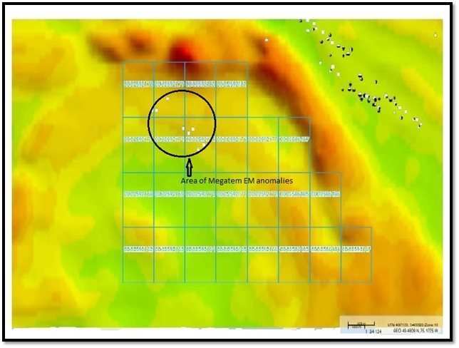
Figure 3: Gold45 Property Megatem Anomalies
6.2 Industry Sponsored Surveys
The history of direct exploration work completed on the Property is limited according to MERN online records. In 1974, the Battelle Columbus Laboratories of Ohio undertook an economic minerals study of the James Bay Region on behalf of the James Bay Development Corporation (MERN report 34002). The scale of the study was so large that the information had little applicability to the Property Area.
A similar study was completed in 1979 entitled “Etude Preliminaire du Potentiel en Mineraux Industriels & Certains Metalliques du Territoire” by R. A. Marleau DSc. (MERN report GM38167). As in the James Bay Region study noted above, the scale of the study was very large with little applicability to the Property Area.
| 18 |
In 2005, the Table Jamesienne De Concertation Miniere completed a glacial esker sampling survey for heavy minerals in the region within NTS Map Sheet 32G06 entitled “Rapport d’une champagne d’echantillonnage d’esker et d’analyse de mineraux lourds” (MERN report GM62919).
In 2005 the Diversification de L’Exploration Minerale au Quebec (DIVEX) completed a 3D modelling study of brecciated and mineralized geological formations in the Chibougamou region entitled “Modelisation 3D des corps brechiques et mineralises” (MERN report GM62902).
In April 2011, Prospectair completed an airborne magnetic survey for Ressources Cartier on their Deigo property located in map sheet 32G06, in which the area surveyed touches the northeast corner of Property claim 2592181. The survey instrument used was a Geometrics G-822A magnetometer mounted in a Robertson R-44 helicopter flown at an average height of 40m and with approximately 100 m line spacings. The survey has limited applicability as the area of Gold45 Property covered by this survey was very minimal.
7.0 GEOLOGICAL SETTING AND MINERALIZATION
7.1 General Geology
The Project area is located within the Superior Structural Province of the Canadian Shield (the “Shield”) in the eastern part of Canada. Glacial debris of variable thickness covers these Precambrian formations as overburden where the Shield is not exposed at surface as outcrop.
The Abitibi Sub-province is the world’s largest contiguous area of Archean volcanic and sedimentary rocks that host a significant number of base and precious metal mineral deposits. Bedrock exposure is generally minimal over much of the region. Much of the geological information and structural features of the regional bedrock have been derived from surface exploration work including diamond drilling in the region, surface trenching and conventional surface geophysical surveys. Detailed information from underground mapping and related structural studies, have also contributed to a better understanding of the geologic and metallogenic features of the ore bodies of the Chibougamau Camp.
The volcano-sedimentary Matagami-Chibougamau Archean Belt represents the eastern portion of the well-known “Abitibi Volcanic Belt”. The Matagami – Chibougamau “band” occupies the northeastern part of the Abitibi Belt. It has been characterized as the “Internal Zone” of the Abitibi Belt. This band extends over a distance of more than 400 km from the western Kapuskasing Structural Zone and east to the Grenville Front.
| 19 |
The general appearance of the regional features is one of oval-shape batholiths surrounded by east-west trending “greenstone belts” usually “wrapping” around the batholiths. Regional and local folding is common and the dips of the formation are usually sub-vertical. Further to the east, Proterozoic sedimentary rocks lie horizontally on the Archean basement.
The Matagami-Chibougamau band differs from the Kirkland – Noranda – Val d’Or band by the presence of large “stratiform differentiated complexes” such as the Lac Doré Complex, Lac Des Chaleur Complex, Opiwaca River Complex and the Bell River Complex.
The greenstone belts are generally metamorphosed from lower/middle greenschists facies to locally lower amphibolite facies as a result of the “Kenorean Orogeny” (2,600 to 2,800 Ma.). Contact metamorphism is also locally well developed. Just east-southeast of the Chapais- Chibougamau area, the grade of metamorphism increases toward the Grenville Front. The Grenville Front represents a tectonic zone separating the Superior Province from the Grenville Province.
The “Abitibi Volcanic Belt” has been affected by numerous phases of deformation. The main deformation episode created large E-W trending, steeply dipping isoclinal folds. The center or axial zone of these folds is commonly occupied by intrusive bodies.
7.2 Regional Geology
Regionally all rocks are archean in age and belong to the Superior Province, with the exception of Proterozoic diabase dykes. Within the region of the Property the Obatogamau Formation forms base of the stratigraphic sequence and is composed of tholeiitic basalts, thought to represent a vast deep-sea plain. The presence of large plagioclase phenocrysts is a common characteristic of this unit.
The Obatogamau Formation contains the Vents and Phooey members. The Vents Member is composed of a 2-2.5 km thick mafic-felsic volcanic edifice which includes 5 felsic units interbedded with basaltic flows and gabbroic sills of the Obatogamau Formation. The lower units represent the constructional phase of the edifice whereas the upper unit, composed of volcanic sandstones and conglomerates, is related to its destruction. The Phooey Member is poorly documented and includes a volcanoclastic sequence related to an intermediate to mafic volcanic centre, located in the SE part of the region.
| 20 |
The Obatogamau Formation is overlain by the Caopatina Formation, a 1 to 2 km thick sedimentary sequence derived from the erosion of volcanic rocks. The sediments include sandstones, conglomerates and argillites locally interbedded with ash tuffs and basalt flows, which indicate coeval volcanic activity.
In the western end of the region, the Obatogamau Formation is intruded by the Opawica River anorthosite complex. This stratiform intrusion is the product of fractional crystallisation from a tholeiitic magma, its morphological and chemical characteristics suggests an affinity to the Obatogamau Formation basalts.
The granitoid intrusions of the region are divided into 2 groups, syn-volcanic plutons, which generally occur in regional anticlines, and syn-tectonic plutons. The syn-volcanic intrusions are generally polyphase and were emplaced prior to regional deformation. They are related to the volcanic sequences. Regional deformation controlled the emplacement of the syn-tectonic intrusions. They are generally elongated parallel to regional foliation and were intruded along the margins of syn-volcanic plutons.
Structurally the region underwent N-S shortening during the Kenoran orogeny which resulted in regional scale folds and an E-W trending schistosity. This deformation event is thought to be responsible for the development of large deformation zones related to E-W trending faults and NE trending brittle-ductile faults in the Caopatina segment. The rocks are also affected by late brittle NE to NNE trending faults probably related to the Grenville orogeny. Evidence for a pre-regional deformation event has also been documented in several localities in the belt.
7.3 Local Geology
The La Tour Pluton underlies most of the western and central Property area, bounded along the northern and northeastern corner of the Property by the Obatogamau Formation.
| 21 |
The Obatogamau Formation
The basalts of the Obatogamau Formation are deformed and metamorphosed to greenschist facies. Massive, pillowed and brecciated basalts and andesitic basalts of this formation are characterized by the common presence of plagioclase phenocrystals associated with the development of a glomerophyric texture. Massive and pillowed facies are the most common. The pillows’ long axis ranges from 10 to 40 cm, but can reach more than one metre in deformation corridors. They may contain millimetric ovoid carbonate-chlorite amygdules. The brecciated facies is scarce and characterized by angular fragments ranging in size from 1 to 5 cm. The rock is uniformly green in fresh exposure with beige phenocrystal clusters (glomerorphyric texture) up to 3 cm in diameter. The rock has a dark green to orange-brown colour in shear zones dominated by chlorite and ankerite alteration, and light green to beige in areas with abundant silica and epidote. Silicification is associated with intense fracturing and the increased presence of quartz veinlets. In all cases, alteration accentuates the contour of primary structures (pillow margins, flow breccia fragments). In deformation corridors, mafic volcanic rocks are transformed into chlorite-sericite ± ankerite schist. Intense deformation and alteration have partially obliterated primary structures.
The La Tour Pluton
The syn-tectonic La Tour pluton underlies most of the Property area and consists of intrusive granodiorite. This rock formation exhibits a foliation consisting in part by the alignment of the plagioclase crystals and by the flattening of the quartz and is usually parallel to the edge of the intrusion. Early dikes in the neighbouring basalts of the Obatogamau Formation linked to the La Tour Pluton show a folding effect.
The granodiorite pluton rock is gray to pale pink in color. Near the margins of the intrusion the rock is fine grained, and becomes medium grained in central areas. The texture of the rock is generally granular hypidiomorphic. Plagioclase constitutes the principal mineral and occurs in the form of hypidiomorphic to idiomorphic grains. Epidote, hornblende, chlorite, biotite, sphene, zircon, apatite and opaque minerals constitute the accessory phases of the La Tour granodiorite. Plagioclase is sometimes altered to epidote and sericite and crystals in brecciated zones are generally of the same composition, or may show antiperthitic textures. Microcline and quartz are generally the same size as plagioclase, but in lesser amounts. Coarse grains of microcline are hypidiomorphic to automorphic and contain inclusions of idiomorphic plagioclase and quartz, while the fine grains are hypidiomorphic to xenomorphic and are found in an interstitial position. Quartz grains can also show elongated xenomorphic shapes with rolling extinctions. These minerals likely formed from the borders of recrystallized grains involved in ductile deformation, and as a result of the friction associated with the ascent and emplacement of the pluton.
| 22 |
7.4 Local Mineralization
The presence of the Joe Mann gold mine and the abundance of important gold and base metal showings demonstrate a high mineral potential for the region. West of the Joe Mann mine, the region also contains the Lac Shortt and Lac Bachelor gold deposits in addition to the Coniagas Zn-Pb-Ag deposit.
Base metal showings in the region are not significant so information for them is limited. Government sponsored studies has divided these showings into the following categories:
|
| · | Cu-Zn-Au-Ag volcanogenic massive sulphide type mineralization related to mafic-felsic volcanic centres; |
|
|
|
|
|
| · | Zn-Cu-Au-Ag shear zone hosted mineralization in mafic flows, sediments and graphitic tuffs; |
|
|
|
|
|
| · | Cu-Au-Ag-Mo vein hosted mineralization related to EW or NE trending shear zones in mafic volcanic rocks and related intrusions; |
|
|
|
|
|
| · | Cu-Ni Platinum Group Element (PGE) magmatic type mineralization in mafic volcanic rocks and related intrusions. |
Gold showings in the region have been grouped into four categories based on the host lithology and structural setting:
|
| · | Gold mineralization related to E-W trending, stratification parallel, shear zones in mafic volcanics and associated mafic intrusions in quartz-sulphide vein type gold mineralization or disseminated pyrite type mineralization |
|
|
|
|
|
| · | Disseminated pyrite type mineralization; |
|
|
|
|
|
| · | Gold mineralization related to NE and NW trending shear zones that cross-cut mafic volcanics and associated mafic intrusions; |
|
|
|
|
|
| · | Gold mineralization hosted by intermediate to felsic intrusions; |
|
|
|
|
|
| · | Gold mineralization hosted by felsic volcanic rocks, with graphitic sediments and/or “iron formations”. |
| 23 |

Figure 4: Gold45 Property Local Geology
8.0 DEPOSIT TYPES–CHIBOUGAMAU AREA
There are several types of Archean lode gold deposits within the Superior Province, for the most part they are dominated by epigenetic and structurally-controlled mesothermal deposits. Other types of deposits include disseminated and stockwork porphyry-related deposits, with or without vein overprints, sulphide-rich breccia and replacement deposits, gold-rich VMS deposits and gold-rich pyrite exhalites. Examples of these deposits types are found within the Chibougaumau region.
| 24 |
Typically Archean gold deposits occur at, or near fault zones marking boundaries between lithologically contrasting domains within greenstone belts or along their margins. In the Abitibi greenstone belt, the majority of the large Archean gold deposits occur in high order splay faults in close proximity to regional faults, suggesting the close genetic correlation to the timing of the structures. This is due to the mineralized veins or disseminations requiring highly permeable channel ways to transport the volume of gold-bearing hydrothermal fluid needed to provide the amount of gold found in these deposits. In the Abitibi, gold is most often found in mafic meta-volcanics and late tectonic stage intrusions. The timing of epigenetic gold mineralization is relatively late. In addition, there is a close spatial and temporal association with porphyry and alkali intrusions which both pre- and post-date the dominant tectonic event. In the Abitibi, the termination of gold mineralization is considered to be pre- to peak- metamorphic.
Epithermal gold deposits form during the infiltration of hydrothermal fluids derived, depending on metallogenic model, from a number of possible sources including magmatic and/or metamorphic and/or meteoritic systems. These systems transport “metals” which are channelled and deposited along pre-existing structures and fractures.
Porphyry deposits are the world’s most important source of Cu and Mo, and are major sources of Au, and Ag (Sinclair 2007). Porphyry deposits are large, low- to –medium grade deposits in which primary ore minerals are dominantly structurally controlled and which are spatially and genetically related to felsic to intermediate porphyritic intrusions. They are characterized by stockworks, veins, veins sets, fractures, and breccias. Three main types of “porphyry deposits” are grouped as follows;
|
| - | Porphyry Cu: grades in copper ranges from 0.2% to more than 1.0% |
|
|
|
|
|
| - | Porphyry Mo: Mo grades range from 0.07% to nearly 0.3% |
|
|
|
|
|
| - | Porphyry Au & Cu-Au: Au grades range from 0.2 to 2.00 g/t Au |
Associated igneous rocks vary in composition from diorite-granodiorite to high-silica granite; they are typically porphyric epizonal to mesozonal intrusions, commonly subvolcanic. A close temporal and genetic relationship between magmatic activity and hydrothermal mineralization in porphyry deposits is indicated by the presence of inter-mineral intrusions and breccias that were introduced between or during periods of mineralization. Porphyry deposits range in age from Archean to Recent, although most economic deposits are Jurassic or younger.
| 25 |
Within the Chibougamau mining camp, the “Troilus deposit” represents a good example of porphyry-style mineralization of Archean age. The Pb, Zn, Au, Ag veins at Berrigan could be peripheral to the “porphyry” intrusion. Associated igneous rocks vary in composition from diorite-granodiorite to high-silica granite; they are typically porphyric epizonal to mesozonal intrusions, commonly subvolcanic. A close temporal and genetic relationship between magmatic activity and hydrothermal mineralization in porphyry deposits is indicated by the presence of inter-mineral intrusions and breccias that were introduced between or during periods of mineralization. Porphyry deposits range in age from Archean to Recent, although most economic deposits are Jurassic or younger (see Figure 6).

Figure 5: Porphyry Copper System Showing Mineral Zonation
| 26 |
9.0 EXPLORATION
According to Boxxy Inc.’s representative no exploration work (ie. prospecting/mapping, ground geophysical surveying, diamond drilling) has been undertaken at the Gold45 Property. As described in the Section 6 of this report, the MERN website documents no previous direct significant exploration work (ie. prospecting/mapping, ground geophysical surveying, diamond drilling etc.) by industry members on the Gold45 Property Claims.
10.0 MINERAL RESOURCE ESTIMATES
Presently, no mineral resources are known to exist on the Property.
11.0 ADJACENT PROPERTIES
The Chibougamau area has recently seen an increase in mineral exploration following the discovery of new gold mineralization, such as IAMGOLD/TomaGold with the Monster Lake (1.11 million tonnes grading 12.14 g/t gold for 433,000 ounces of gold; IAMGOLD, 2018) and IAMGOLD/Vanstar with the Nelligan gold deposits. Although much of the area has undergone detailed mineral exploration over the years, many areas remain relatively unexplored and have strong potential.
According to the MERN website as of the dat of this report, the Property is contiguous with claims registered (100%) to 9148-5706 Quebec Inc. (Multi-Resources Boreal) along its north and northeast boundary (claims 2592178 – 2592181). Central east boundary claims (2586487 and 2586488) are contiguous with claims registered (100%) to Visible Gold Mines Inc. Southeast boundary claims (2592167 and 2586486) are contiguous with claims registered (100%) to Jean Lafleur. Claims along the entire south and west boundary are presently (as of the date of this report) open for staking.
No economic mineral deposits with NI 43-101 compliant reserve estimates are known to exist on the property immediately adjacent to the Property. The closest active mine development project is the IAMGOLD/Vanstar Neligan project which is located approximately 30 km east-southeast of the Property.
12.0 OTHER RELEVANT DATA
The author is aware of no other relevant data.
| 27 |
12.1 Structures and Arable Land
The Property covers no arable land.
13.0 INTERPRETATION AND CONCLUSIONS
Typically Archean gold deposits occur at, or near fault zones marking boundaries between lithologically contrasting domains within greenstone belts or along their margins (ie. in relation of the Property the contact between the Obatogamau formation and the La Tour Pluton). In addition, associated igneous rocks in porphyry type intrusion deposits vary in composition from diorite-granodiorite (such as in the La Tour Pluton) to high-silica granite.
As documented in Section 6.0, historical records maintained by the MERN document no history of industry exploration work on the ground covered by the Gold45 property claims, consequently the is considered to be a “grass-roots” early stage project. Government sponsored work consists of regional studies associated with on the ground geological mapping and airborne geophysics (magnetic and electromagnetic) surveys. Clearly a contributing factor to the lack of historical exploration work and related geological information is that Lac Doda covers much of the Property area, and there appears to be a general lack of outcrop in the remaining low lying Property areas.
The Chibogaumau-Chapais region has a rich history of mineral discoveries and mining production including quite recently, in areas with similar geological characteristics to the Gold45 mineral claims. In particular the Gold45 claims have geology which could be considered prospective for epithermal style and porphyry style gold mineralization.
A Fugro MegatemII 1-2 Channel EM anomaly has been identified near the northwest corner of the Property within Lac Doda having an approximate strike length of 1,000 m and orientated in a direction that is roughly parallel to local geological strike (NW-SE). While it is possible that this anomaly may be related or caused by local lake bottom sediments that may be high in clay content, or a graphitic horizon in the local bedrock, it may also constitute a potential exploration target. Gold is known to form organo-metallic complexes under certain natural conditions and may also be transported in colloidal form or adsorbed on clay particles from bedrock sources into the lacustrine environment. Any gold so transported should be scavenged by the humic material usually found in profundal lake sediments, close to its source given gold’s high density. Therefore a program of lake sediment sampling over the anomaly area will be useful in determining the nature/source of this anomaly and potential target.
| 28 |
In addition a localized magnetic high is found along the north shore of Lac Doda within claim 2592180 that is unexplained and warrants further detailed prospecting.
14.0 RECOMMENDATIONS
A two phase exploration program is recommended for the Property.
Phase I work includes a detailed compilation and integration of all available exploration data from the MERN website. An analysis of the airborne MegatemII data for the Lac Doda EM anomaly by a qualified geophysicist is to be included in the recommended compilation as this may be useful in determining the source of the anomaly, i.e. such as a vertical conductive body (related to potential mineralization) or lake bed sediments consisting of a clay layer.
A detailed ground prospecting mapping program is also recommended during the spring/summer/early fall season along the contact between the Obatagamau formation and La Tour formation (ie the northeast shoreline of Lac Doda). Lake bed sediment sampling survey over the Lac Doda Em anomaly is also recommended (if warranted after geophysical analysis) during the summer season (via boat incorporating a sediment grab sampler).
Phase II is to be conducted during the winter months and consists of a detailed ground magnetometer and horizontal loop EM survey over the northern half of Property Area focussing on the Lac Doda EM anomaly area. A winter survey will allow access over the Property area covered by La Doda. Northeast southwest lines grid lines are recommended at 100 m spacings (roughly 45 kilometers).
Any targets that are developed from Phase I and II should be tested with follow-up trenching and/or diamond drilling.
The estimated cost of the recommended program is $52,800, the details of which are provided in Table 2. In costing the recommended program, the author has that a geophysical analysis of Megatem data warrants further investigation of the Lac Doda EM anomaly.
| 29 |
Table 2: Estimate of Program Cost
| ACTIVITY |
| ESTIMATED COST |
| |
| Compilation of Exploration Data, including MegatemII Geophysical Analysis |
| $ | 8,500 |
|
| Lake Bed Sampling (2 men at $500 per day+ boat rental, accommodation and travel) |
| $ | 3,000 |
|
| Geophysical Surveying (ground mag + EM @ $500 per km) |
| $ | 22,500 |
|
| Contigencies (add 10%) |
| $ | 4,800 |
|
| Total Project (I+II) |
| $ | 52,800 |
|
| 30 |
15.0 CERTIFICATE OF AUTHOR
This Certificate applies to the report contained herein entitled “TECHNICAL REPORT FOR BOXXY INC. ON THE GOLD45 PROJECT N.T.S. REFERENCE 32G06, QUEBEC, CANADA” effective date March 26, 2021. Mr. Hawkins prepared and is responsible for all sections of this report.
I, Warren Hawkins, P.Eng do hereby certify that:
|
| 1. | I am an independent consulting engineering geologist and a citizen of Canada residing at 33 University Ave., Apt. 1803., Toronto, ON, M5J 2S7; |
|
|
|
|
|
| 2. | I am a graduate of the University of Waterloo, 1989 and majored in economic geology and geophysics; |
|
|
|
|
|
| 3. | I am a Professional Engineer (P.Eng ) in good standing with the Association of Professional Engineers of Ontario (PEO); |
|
|
|
|
|
| 4. | I have been practicing my profession related to mining and mineral exploration for over 20 years in a wide variety of locations in North America. Specific to the content of this report is my work in Ontario on gold deposits the Moss Lake gold Discovery, Shebandewan Greenstone Belt. Northwestern, Ontario; |
|
|
|
|
|
| 5. | As at the effective date of this report (March 26, 2021), to the best of my knowledge, information and belief, the Sections of this technical report in which Mr. Hawkins prepared contains all scientific and technical information that is required to be disclosed to make this technical report not misleading. |
Dated this 26th day of March, 2021.

____________________________
Warren Hawkins, P.Eng
| 31 |
16.0 SELECTED REFERENCES
MERN webpages: sigeom.mines.gouv.qc.ca, gestim.mines.gouv.qc.ca
MERN Report MB 2009-28 “Outil di Visualisation et d’Interrogation Des Anomalies Megatem II Pour le Secteur de Chibougamau”. Unite de recherché et de service en technologie minerale. Li Zhen Cheng, Ph.D, David Bouchard, tech. March 2009.
MERN Report MB 99-33 “Compilation et synthese geologique et metallogenique du Segment de Caopatina, region de Chibougamau”. Geologie Quebec, 1999.
MERN Report MB 93-12 “Geologie Du Sector Du Lac Doda (Feuillet 32/G06) Bande Caopatina-Desmaraisville (Sous-Province de L’Abitibi)”. Geologie Quebec, 1994.
MERN Report DV 98-04 “Geology and Metallogeny of the Chapais-Chibougamau Mining District: A new Vision of the Discovery Potential”. Proceedings of the Chapais-Chibougamau 1998 Symposium. Pierre Pilote Editor.
DP 2008-36 “Cartes Geophysiues Couleur Megatem – 32G06. Noranda Exploration Mines d’Or Virginia”. Geological Survey of Canada, 2008.
MERN Report GM 32827 “Report on the Geophysical Surveys on Part of Property Owned by Falconbridge Nickel Mines Ltd., Chibougama Proejct, Doda Lake”. Clermont Lavoie, Ph.D. October 1977.
MERN Report GM 62919 “Rapport d’une champagne d’echantillonnage d’esker et d’analyse de mineraux lourds. Sector (32G), Quebec”, Table Jamesienne de Concertation Miniere, July 2005.
| 32 |