Attached files
| file | filename |
|---|---|
| 8-K - FORM 8K - NORSTRA ENERGY INC | norx8k_reserve-estimate.htm |
| EX-99.2 - NEWS RELEASE DATED JUNE 3, 2013 - NORSTRA ENERGY INC | reserve_estimate-release.htm |
South Sun River Bakken Prospect Reserve Estimate
Lewis and Clark County, Montana
Prepared for: Summit West Oil, LLC
By
David A. Lopez, Ph.D.
Consulting Geologist
AAPG Certified Petroleum Geologist #4210
Billings, MT
May 29, 2013
Qualifications—Dr. David A. Lopez
§ Education:
o University of Colorado, B. A., (Geology), 1973
o University of New Mexico, M. S., (Geology), 1975
o Colorado School of Mines, Ph. D., (Geology), 1981
§ American Association of Petroleum Geologists (AAPG) Certified Petroleum Geologist #4210.
§ I have 36 years of experience as a professional geologist; 29 years in oil and gas exploration and research.
§ I am a member of the following professional organizations
o American Association of Petroleum Geologists
o Geological Society of America (Fellow)
o Montana Geological Society
|
Respectfully Submitted,
Dr. David A. Lopez |
|

Executive Summary
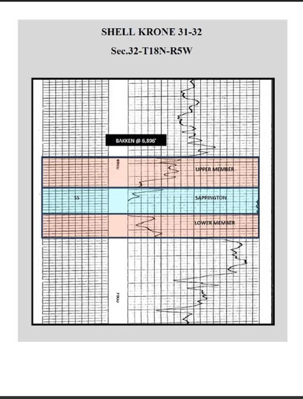
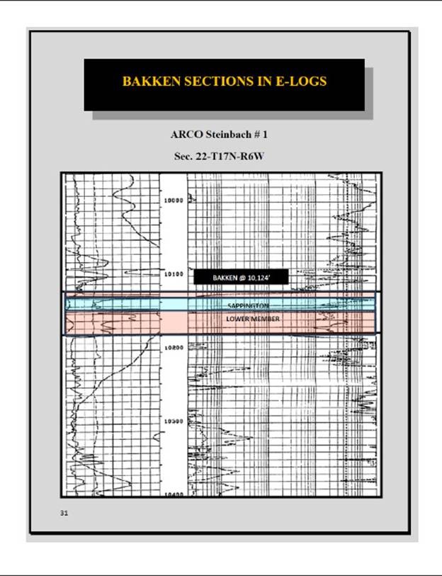
An estimate of Original Oil in Place (OOIP) was calculated for the South Sun River Prospect based on petrophysical data from logs of oil wells nearest the project area; the Shell-Krone #31-32, and ARCO-Steinbach #1. These estimates are: High Expected Reserves—16.7 MMBO/Section; Average Expected Reserves—13.1 MMBO/Section; and Low Expected Reserves—9.5 MMBO/Section.
Prospect
The South Sun River Prospect is an exploration project in Lewis and Clark County, west of Great Falls, MT in the area of the leading edge of the Rocky Mountain Overthrust Belt. The Bakken Formation in this area is the southern continuation of the “Canadian Bakken” farther north and continues into southwestern Montana where it is called the Sappington Formation. Several wells drilled in the area have Bakken sections very similar to the Bakken in the Williston Basin (Figure 1).
|
Figure 1. Bakken type log from the Williston Basin (from Hansen and Long, 1991). | |
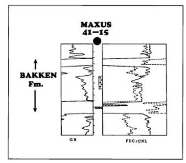
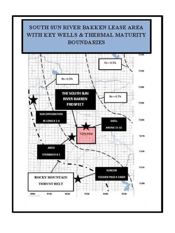
Figure 2. Vitrinite Reflectance Map of project area showing lease block and key wells (Map provided by KTH Oil & Gas).
Reserve Calculations
Reserve estimates for the South Sun River Prospect area were calculated based on the log data from the two wells in closest proximity. The Shell-Krone #31-32 is immediately adjacent to the project area on the north (Section 32, T18N, 5W). The ARCO-Steinbach #1 is west of the project area (Section 22, T17N, R6W). Geophysical logs from these two wells are included below. Reserve estimates were calculated assuming that the middle member would be completed as the oil reservoir rock, and that there would be very low water saturation based on the high Rt values. The estimates also assume that the reservoir quality in the Bakken will remain relatively constant across the prospect area. The Steinbach well has the thinnest section and was used as the low expected reserve estimate; porosity from this well is from a Sonic log. The Krone well has a thicker section and the best porosity and was used for the high expected reserve estimate. A conservative porosity of 12% for the Krone well was taken from the Neutron log; the very good SP response in this well confirms the presence of well-developed porosity, possibly greater than 12%. Reserve estimates are for total original oil in place (OOIP). The data used and reserves calculated are presented in the table below.
Table 1. Bakken Reserve Estimate Calculations
|
|
Well |
Porosity |
Thickness |
Acres |
Acre/ft |
OOIP (MMBO) per Section |
|
High Expected Reserves |
Shell-Krone #31-32 |
12% |
28 ft |
640 |
2150 |
16,680,495 |
|
Average Expected Reserves |
13,107,765 | |||||
|
Low Expected Reserves |
Arco-Steinbach #1 |
12% |
16 ft |
640 |
1229 |
9,535,036 |
|
OOIP = Acre ft X 7758.37 Barrels oil/acre ft |
||||||