Attached files
| file | filename |
|---|---|
| 8-K - 8-K - HEXCEL CORP /DE/ | a12-2906_38k.htm |
| EX-99.1 - EX-99.1 - HEXCEL CORP /DE/ | a12-2906_3ex99d1.htm |
Exhibit 99.2
Prepared by:
|
/s/ Michael B. Tindle |
|
|
Michael B. Tindle, Attorney |
|
|
Tennessee Valley Authority |
|
|
1101 Market Street, SP 3L |
|
|
Chattanooga, Tennessee 37402-2801 |
|
|
Telephone: (423) 751-6317 |
TVA Tract No. XWR-633 |
SPECIAL WARRANTY DEED
THIS INDENTURE, made and entered into this 20th day of January, 2012, by and between the UNITED STATES OF AMERICA (hereinafter sometimes referred to as “GRANTOR”), acting herein by and through its legal agent, the TENNESSEE VALLEY AUTHORITY (hereinafter sometimes referred to as “TVA”), a corporation created and existing under an Act of Congress known as the Tennessee Valley Authority Act of 1933, as amended, and ,(hereinafter sometimes referred to as the “GRANTEE”);
W I T N E S S E T H
WHEREAS Section 31 of the above-mentioned Act of Congress authorizes and directs TVA, as agent of the UNITED STATES OF AMERICA, to sell at public auction after due advertisement to the highest bidder any land purchased by TVA in the name of the UNITED STATES OF AMERICA not necessary to carry out plans and projects actually decided upon; and
WHEREAS no permanent dam, hydroelectric power plant, fertilizer plant, or munitions plant is located on the land hereinafter described and designated in TVA land records as Tract No. XWR-633(sometimes hereinafter referred to as the “Land”), and the TVA Board of Directors, through its designee, the Chief Executive Officer of TVA, has determined that theLand is not necessary to carry out any of its plans and projects actually decided upon; and
WHEREAS TVA pursuant to and in accordance with the provisions of said Act of Congress advertised theLand for sale at public auction; and
WHEREAS pursuant to said advertisement theLand was offered for sale at public auction onJanuary 20, 2012, at the Morgan County Courthouse in Decatur, Alabama, and the terms of said public auction having been cried for a reasonable time, theLand was finally sold to the GRANTEE for the sum of AND NO/100 DOLLARS ($ ), that being the highest and best bid made at said public auction.
NOW, THEREFORE, in consideration of the premises and the full payment of the aforesaid bid, receipt whereof is hereby acknowledged, TVA as legal agent for the UNITED STATES OF AMERICA does hereby bargain, sell, transfer, and convey unto the GRANTEE for industrial purposes only, a parcel of land designated in the TVA land records as Tract No. XWR-633, more particularly described in Exhibit A and shown on Exhibit B (the “Land”), which are hereby attached and made a part of this instrument.
Furthermore, GRANTEE shall have the right to construct, operate, and maintain, at locations, and in accordance with plans approved in advance and in writing by TVA: water-use facilities for industrial purposes on and over the adjoining land lying between the 560-foot contour elevation and the adjacent waters of the lake and in and on such waters; and the further right of suitable ingress and egress to and from the waters of the lake and to and from all structures, facilities, and improvements maintained in, on, or over said land or waters pursuant to the rights herein conveyed, all upon the express condition that said rights shall be subject to and shall not in any way interfere with TVA’s statutory program for river control and
development, including, but without limitation by reason of enumeration, TVA’s right to flood the land lying below the 560-foot contour elevation or TVA’s right to do anything which TVA deems necessary or desirable in the promotion of vector control, flood control, navigation, or other programs, and TVA shall not be liable for any loss or damage resulting therefrom; provided that in the exercise of TVA’s rights, TVA shall use its best efforts to avoid any unreasonable or unnecessary interference with GRANTEE’s use of the Land.
GRANTEE, as a condition of this conveyance, shall within four (4) years from the date of this transfer invest a minimum of $150,000,000 on the Land in support of industrial use and create at least 25 jobs stemming from the operations on the Land. GRANTEE shall furnish evidence of the investment and job creation in writing and to the satisfaction of TVA. Upon GRANTEE’s provision of satisfactory evidence, GRANTOR and/or TVA shall provide to GRANTEE written acknowledgement of its completion of the investment and job creation requirements and, if requested by GRANTEE and at GRANTEE’s expense, shall prepare and record a document acknowledging such completion. In the event GRANTEE has not made said minimum investment and job creation within four (4) years from the date of this transfer, the GRANTOR, TVA, or their successors and assigns, may reenter and take possession of the Land as if this conveyance had never been made and without repayment of the purchase price.
GRANTOR reserves a permanent easement and right-of-way, all over, upon, across, and under the portion of the Land described in said Exhibit A and shown on said Exhibit B as “Transmission Line Easement,” for the following purposes, namely:the perpetual right to enter at any time and from time to time and to erect, maintain, repair, rebuild, operate, and patrol lines of transmission line structures with wires and cablesfor electric power circuits and communication circuits and all necessary appurtenances; to clear saidright-of-way and keep it clear of all trees, brush, buildings, signboards, billboards, stored personal property, and fire hazards; to destroy or otherwise dispose of such trees and brush; to prevent the drilling or sinking of wells within the right-of-way; and to remove, destroy, or otherwise dispose of any trees located beyond the limits of the right-of-way which in falling could come within ten (10) feet of any transmission line structure or conductor.
GRANTOR reserves,for the benefit of itself and its successors and assigns, the right to maintain any existing boundary and traverse monuments and silt range stations upon the Land.
GRANTEE, by acceptance of this Special Warranty Deed, covenants and agrees on behalf of itself,its successors, andassigns that the following shall constitute real covenants which shall attach to and run with the Land hereby conveyed and shall be binding upon anyone who may hereafter come into ownership thereof, whether by purchase, devise, descent, or succession:
|
(a) |
Use of theLand shall be limited to industrial purposes only. |
|
|
|
|
(b) |
GRANTEE shall control all emissions of pollutants that might be discharged or released directly or indirectly into the atmosphere, into any stream, lake, reservoir, watercourse, or surface or subterranean waters, or into or on the ground from any part of theLand, in full compliance with all applicable standards and requirements relating to pollution control of any kind now in effect or hereafter established by or pursuant to federal, state, or local statues, ordinances, codes, or regulations. |
|
|
|
|
(c) |
GRANTEE shall conduct all land-disturbing activities on theLand in accordance with best management practices to control erosion and sedimentation so as to prevent adverse impacts on water quality and related aquatic interests in order to meet the requirements of Section 208 of the Clean Water Act and implementing regulations. |
|
|
|
|
(d) |
GRANTEE shall within four (4) years from the date of this transfer invest a minimum of $150,000,000 on the Land in support of industrial use and create at least 25 jobs stemming |
|
|
from the operations on the Land. GRANTEE shall furnish evidence of the investment and job creation in writing and to the satisfaction of TVA. |
|
|
|
|
(e) |
GRANTEE shall not construct any future facilities or equipment subject to flood damage unless located above or floodproofed to the elevation of 560.2 feet mean sea level. |
|
|
|
|
(f) |
GRANTEE shall mitigate impacts to non-jurisdictional wetlands on the Land at the ratio of 1:1 and comply with all applicable requirements proscribed by the United States Army Corps of Engineers for impacts to jurisdictional wetlands located on the Land. |
TheLand is sold subject to the following: 1) such rights as may be vested in the state, county, or adjoining owners in any public road running through the Land; 2) such rights of third parties as would be revealed by a physical inspection or survey of the premises; 3) such rights of third parties as would be revealed by an examination of the public records of Morgan County, Alabama; and 4) any known or unknown encroachments located on the Land.
TO HAVE AND TO HOLD the Land unto GRANTEE and its successors and assigns, in fee simple together with all and singular, the hereditaments and appurtenances thereunto belonging or in anywise appertaining.
And TVA does hereby covenant that the UNITED STATES OF AMERICA is seized and possessed of the Land; that TVA as legal agent of the UNITED STATES OF AMERICA is duly authorized to convey the same; that theLand is free and clear of liens and encumbrances; and that, subject only to such exceptions, conditions, restrictions, and/or limitations as may be expressly mentioned above, it will warrant and defend the title thereto against the lawful demands of all persons claiming by, through, or under the UNITED STATES OF AMERICA, but not further or otherwise.
Wherever in this instrument the word “GRANTOR” or “GRANTEE” are used, it is understood that their successors and assigns are included.
IN WITNESS WHEREOF, the TENNESSEE VALLEY AUTHORITY, acting herein as legal agent of the UNITED STATES OF AMERICA, and being duly authorized to do so, has caused this instrument to be executed, in the name of the UNITED STATES OF AMERICA, by its authorized officer, this 20thday of January, 2012.
|
|
UNITED STATES OF AMERICA | |
|
|
By TENNESSEE VALLEY AUTHORITY, its legal agent | |
|
|
| |
|
|
| |
|
|
/s/ Daisy A. Snipes | |
|
|
DAISY A. SNIPES | |
|
|
Senior Manager, Realty Services and Land Records | |
|
|
| |
|
|
| |
|
STATE OF TENNESSEE |
) |
|
|
|
) SS |
|
|
COUNTY OF HAMILTON |
) |
|
On the 20th day of January 2012, before me appeared DAISY A. SNIPES to me personally known, who, being by me duly sworn, being informed of the contents of this conveyance, did say that sheis the Senior Manager, Realty Services and Land Records, of the TENNESSEE VALLEY AUTHORITY, a corporation, and that said instrument was signed and delivered on behalf of said corporation, by authority of its Board of Directors, and as legal agent for the UNITED STATES OF AMERICA; and the said DAISY A. SNIPES acknowledged said instrument to be the free act and deed of the UNITED STATES OF AMERICA, as principal, and the TENNESSEE VALLEY AUTHORITY, as its agent.
WITNESS my hand and official seal of office in Chattanooga, Tennessee, the day and year aforesaid.
|
/s/ Reba H. Sime |
|
|
NOTARY PUBLIC | |
Commission Expires: March 6, 2013
|
Address of GRANTOR: |
|
Address of GRANTEE: |
|
United States of America |
|
3300 Mallard Fox Drive |
|
TennesseeValley Authority |
|
Decatur, AL 35603 |
|
c/o Realty Services |
|
|
|
1101 Market Street, SP 3L |
|
|
|
Chattanooga, Tennessee 37402-2801 |
|
|
EXHIBIT A
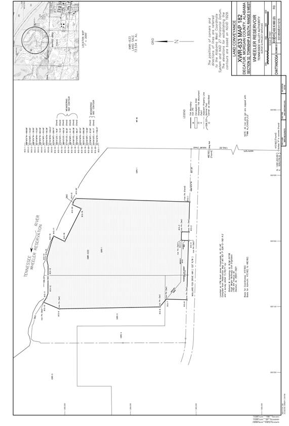
A parcel of land located in Morgan County, State of Alabama, in Section 32, Township 4 South, Range 5 West, City of Decatur, and being on the left bank of the Tennessee River, as shown on US-TVA drawing 03 MS 422K660(D), R.0, and being more particularly described as follows:
Commencing at a scribed “X” in concrete being the southeast corner of Section 32 (Coordinates: N: 1,691,453.69, E: 629,378.22), also being corner No. 47 (182); thence N00°57'32"E, 1620.85 feet, crossing a mag nail (found) in roadway (1342.35 feet), to a point; thence N88°18'01"W, 807.35 feet to an iron pin (found) on the north right-of-way line of Mallard Fox Drive N.W. (120-foot right-of-way width), being corner No. 613-1 and the Point of Beginning.
Thence leaving the point of beginning and with the said road right-of-way line N88°18’01”W, 458.68 feet to a capped iron pin (set) (stamped PWM AL/CA0021/LS), being corner No. 613-2; thence leaving the said road right-of-way line along the following bearings and distances:
N01°24'09"E, 110.00 feet to a capped iron pin (set) (stamped PWM AL/CA0021/LS), being corner No. 613-3; thence
N88°18'01"W, 130.00 feet to a capped iron pin (set) (stamped PWM AL/CA0021/LS), being corner No. 613-4; thence
S01°24'09"W, 110.00 feet to a capped iron pin (set) (stamped PWM AL/CA0021/LS) on the right-of-way line of the said road, being corner No. 613-5; thence with the said road right-of-way line N88°18'01"W, 903.39 feet to a capped iron pin (set) (stamped PWM AL/CA0021/LS), being corner No. 613-6; thence N01°41'59"E, 310.49 feet to a capped iron pin (set) (stamped PWM AL/CA0021/LS), being corner No. 613-7; thence N49°54'45"W, 155.38 feet to a capped iron pin (set) (stamped PWM AL/CA0021/LS), being corner No. 613-8; thence N01°04'39"W, 1532.21 feet to a capped iron pin (set) (stamped PWM AL/CA0021/LS), being corner No. 613-9; thence N23°04'36"E, 258.74 feet to a capped iron pin (set) (stamped PWM AL/CA0021/LS) on the 560 foot mean sea level contour line, hereinafter referred to as (msl) contour line, being corner No. 613-10 ; thence with the meanders of the said 560 foot (msl) contour line in a southeasterly direction the following chord bearings and distances:
S56°31'23"E, 76.81 feet to a point, being corner No. 613-11; thence
S70°43'35"E, 73.16 feet to a point, being corner No. 613-12; thence
S89°43'12"E, 426.16 feet to a point, being corner No. 613-13; thence
N77°20'13"E, 82.20 feet to a point, being corner No. 613-14; thence
S86°18'48"E, 41.15 feet to a point, being corner No. 613-15; thence
S74°09'13"E, 256.38 feet to a point, being corner No. 613-16; thence
S69°10'59"E, 86.47 feet to a point, being corner No. 613-17; thence leaving the meanders of the said 560 foot (msl) contour line along the following bearings and distances:
S26°03'49"W, 187.53 feet to a point, being corner No. 613-18; thence
S63°21'25"E, 559.38 feet to a point, being corner No. 613-19; thence
N24°25'39"E, 144.96 feet to a point on the said 560 foot (msl) contour line, being corner No. 613-20; thence with the meanders of the said 560 foot (msl) contour line in a southeasterly direction the following chord bearings and distances:
S70°06'26"E, 67.83 feet to a point, being corner No. 613-21; thence
S44°04'33"E, 44.17 feet to a capped iron pin (set) (stamped PWM AL/CA0021/LS), being corner No. 613-22; thence leaving the meanders of the said 560 foot (msl) contour line S01°42'32"W, 1729.31 feet to the point of beginning and containing 73.534 acres, more or less.
Less and except the easement rights reserved herein affecting the portion of land described as follows:
Transmission Line Easement
A parcel of land located in Morgan County, State of Alabama, in Section 32, Township 4 South, Range 5 West, City of Decatur, as shown on US-TVA drawing 03 MS 422K660(D), R.0, and being more particularly described as follows:
Commencing at a scribed “X” in concrete being the southeast corner of Section 32 (Coordinates: N: 1,691,453.69, E: 629,378.22), also being corner No. 47 (182); thence N00°57'32"E, 1620.85 feet, crossing a mag nail (found) in roadway (1342.35 feet), to a point; thence N88°18'01"W, 1396.03 feet, crossing an iron pin (found) (807.35 feet) and a capped iron pin (set) (stamped PWM AL/CA0021/LS) (1266.03 feet), to a capped iron pin (set) (stamped PWM AL/CA0021/LS) on the north right-of-way line of Mallard Fox Drive N.W. (120-foot right-of-way width), being corner No. 613-5 of the herein described easement parcel and being the Point of Beginning.
Thence leaving the point of beginning and with the said road right-of-way line N88°18'01"W, 903.39 feet to a capped iron pin (set) (stamped PWM AL/CA0021/LS), being corner No. 613-6; thence leaving the said road right-of-way line along the following bearings and distances:
N01°41'59"E, 310.49 feet to a capped iron pin (set) (stamped PWM
AL/CA0021/LS), being corner No. 613-7; thence
S49°54'45"E, 338.96 feet to a point; thence
S88°18'01"E, 637.18 feet to a point; thence S01°24'09"W, 100.00 feet to the point of beginning and containing 2.715 acres, more or less.
The positions, distances and directions of lines are referred to the Alabama West State Plane Coordinate System, NAD27 Horizontal Datum, and NGVD 1929 Vertical Datum.
Located on VTM Quad Jones Crossroads, Alabama 61-NE.
This description was prepared from US-TVA drawing 03 MS 422K660(D), R.0, and a survey dated November 30, 2011, by:
Richard W. Humphrey, Alabama RLS No. 22738
Pugh Wright McAnally Civil Engineers
1740 5th Ave SE
Decatur, AL 35601-5921
EXHIBIT B