Attached files
| file | filename |
|---|---|
| 8-K - Midway Gold Corp | midway8k_110111.htm |
EXHIBIT 99.1
NI 43-101 Updated Mineral Resource Estimate
for the
PAN GOLD PROJECT
White Pine County, Nevada
PREPARED FOR MIDWAY GOLD CORP.

Effective date: September 1, 2011
Signature date: November 1, 2011
Prepared by
William J. Crowl, R.G. QP MMSA
Donald E. Hulse, P.E.
Terre A. Lane, QP MMSA
Donald J. Baker, PhD QP MMSA
Jennifer J. Brown, P.G. Registered Member SME
|
Midway Gold Corp.
Pan Gold Project Updated Mineral Resource Estimate
|
Date and Signature Pages
NI 43-101 Technical Report
|
WILLIAM J. CROWL, R.G.
Vice President, Mining
Gustavson Associates, LLC
274 Union Boulevard, Suite 450
Lakewood, Colorado 80228
Telephone: 720-407-4062 Facsimile: 720-407-4067
Email: wcrowl@gustavson.com
CERTIFICATE of AUTHOR
I, William J. Crowl do hereby certify that:
|
1.
|
I am currently employed as Vice President, Mining by Gustavson Associates, LLC at:
|
274 Union Boulevard
Suite 450
Lakewood, Colorado 80228
|
2.
|
I am a graduate of the University of Southern California with a Bachelor of Arts in Earth Science (1968), and an MSc. in Economic Geology from the University of Arizona in 1979, and have practiced my profession continuously since 1973.
|
|
3.
|
I am a member in good standing of the Mining and Metallurgical Society of America, member # 01412QP
|
|
4.
|
I have worked as a geologist for a total of 35 years since my graduation from university; as a graduate student, as an employee of a major mining company, a major engineering company, and as a consulting geologist.
|
|
5.
|
I have read the definition of “qualified person” set out in NI 43-101 (“NI 43-101”) and certify that by reason of my education, affiliation with a professional association (as defined in NI 43-101) and past relevant work experience, I fulfill the requirements to be a “qualified person” for the purposes of NI 43-101.
|
|
6.
|
I am responsible for the preparation of the technical report titled “NI 43-101 Updated Mineral Resource Estimate for the Pan Gold Project, White Pine County, Nevada,” effective date, September 1, 2011 (the “Technical Report”), with specific responsibility for oversight of the Technical Report.
|
|
7.
|
I am not aware of any material fact or material change with respect to the subject matter of the Technical Report that is not reflected in the Technical Report, the omission to disclose which makes the Technical Report misleading.
|
| September 1, 2011 | i |
 |
|
Midway Gold Corp.
Pan Gold Project Updated Mineral Resource Estimate
|
Date and Signature Pages
NI 43-101 Technical Report
|
|
8.
|
I do not hold, nor do I expect to receive, any securities or any other interest in any corporate entity, private or public, with interests in the properties that are the subject of this report or in the properties themselves, nor do I have any business relationship with any such entity apart from a professional consulting relationship with the issuer, nor to the best of my knowledge do I have any interest in any securities of any corporate entity with property within a two (2) kilometer distance of any of the subject properties.
|
|
9.
|
I have read NI 43-101 and Form 43-101, and the Technical Report has been prepared in compliance with that instrument and form.
|
|
10.
|
I consent to the filing of the Technical Report with any stock exchanges or other regulatory authority and any publication by them, including electronic publication in the public company files on the websites accessible by the public, of the Technical Report.
|
Dated this 1st day of November, 2011.
/s/ William J. Crowl (Signature)
Signature of Qualified Person
“William J. Crowl”
Print name of Qualified Person
| September 1, 2011 | ii | |
|
Midway Gold Corp.
Pan Gold Project Updated Mineral Resource Estimate
|
Date and Signature Pages
NI 43-101 Technical Report
|
DONALD E. HULSE, P.E.
Principal Mining Engineer
Gustavson Associates, LLC
274 Union Boulevard, Suite 450
Lakewood, Colorado 80228
Telephone: 720-407-4062 Facsimile: 720-407-4067
Email: dhulse@gustavson.com
CERTIFICATE of AUTHOR
I, Donald E. Hulse do hereby certify that:
|
1.
|
I am currently employed as Principal Mining Engineer by Gustavson Associates, LLC at:
|
274 Union Boulevard
Suite 450
Lakewood, Colorado 80228
|
2.
|
I am a graduate of the Colorado School of Mines with a Bachelor of Science in Mining Engineering (1982), and have practiced my profession continuously since 1983.
|
|
3.
|
I am a registered Professional Engineer in the State of Colorado (35269).
|
|
4.
|
I have worked as a mining engineer for a total of 25 years since my graduation from university; as an employee of a major mining company, a major engineering company, and as a consulting engineer.
|
|
5.
|
I have read the definition of “qualified person” set out in NI 43-101 (“NI 43-101”) and certify that by reason of my education, affiliation with a professional association (as defined in NI 43-101) and past relevant work experience, I fulfill the requirements to be a “qualified person” for the purposes of NI 43-101.
|
|
6.
|
I am responsible for the preparation of the technical report titled “NI 43-101 Updated Mineral Resource Estimate for the Pan Gold Project, White Pine County, Nevada,” effective date, September 1, 2011 (the “Technical Report”), with specific responsibility for Sections 13 and 14.
|
|
7.
|
I am not aware of any material fact or material change with respect to the subject matter of the Technical Report that is not reflected in the Technical Report, the omission to disclose which makes the Technical Report misleading.
|
| September 1, 2011 | iii | |
|
Midway Gold Corp.
Pan Gold Project Updated Mineral Resource Estimate
|
Date and Signature Pages
NI 43-101 Technical Report
|
|
8.
|
I do not hold, nor do I expect to receive, any securities or any other interest in any corporate entity, private or public, with interests in the properties that are the subject of this report or in the properties themselves, nor do I have any business relationship with any such entity apart from a professional consulting relationship with the issuer, nor to the best of my knowledge do I have any interest in any securities of any corporate entity with property within a two (2) kilometer distance of any of the subject properties.
|
|
9.
|
I have read NI 43-101 and Form 43-101, and the Technical Report has been prepared in compliance with that instrument and form.
|
|
10.
|
I consent to the filing of the Technical Report with any stock exchanges or other regulatory authority and any publication by them, including electronic publication in the public company files on the websites accessible by the public, of the Technical Report.
|
Dated this 1st day of November, 2011.
/s/Donald E. Hulse (Signature)
Signature of Qualified Person
“Donald E. Hulse”
Print name of Qualified Person
| September 1, 2011 | iv | |
|
Midway Gold Corp.
Pan Gold Project Updated Mineral Resource Estimate
|
Date and Signature Pages
NI 43-101 Technical Report
|
TERRE A. LANE
Associate Principal Mining Engineer
Gustavson Associates, LLC
274 Union Boulevard, Suite 450
Lakewood, Colorado 80228
Telephone: 720-407-4062 Facsimile: 720-407-4067
Email: tlane@gustavson.com
CERTIFICATE of AUTHOR
I, Terre A. Lane do hereby certify that:
|
1.
|
I am currently employed as Principal Mining Engineer by Gustavson Associates, LLC at:
|
274 Union Boulevard
Suite 450
Lakewood, Colorado 80228
|
2.
|
I am a graduate of the Michigan Technological University of Michigan with a Bachelor of Science degree in Mining Engineering (1982).
|
|
3.
|
I am a member in good standing of the Mining and Metallurgical Society of America, member #10407QP
|
|
4.
|
I have worked as a Mine Engineer for a total of 23 years since my graduation from university; as an employee of several mining companies, an engineering company, a mine development and mine construction company, an exploration company, and as a consulting engineer.
|
|
5.
|
I have read the definition of “qualified person” set out in NI 43-101 (“NI 43-101”) and certify that by reason of my education, affiliation with a professional association (as defined in NI 43-101) and past relevant work experience, I fulfill the requirements to be a “qualified person” for the purposes of NI 43-101.
|
|
6.
|
I am responsible for the preparation of the technical report titled “NI 43-101 Updated Mineral Resource Estimate for the Pan Gold Project, White Pine County, Nevada,” effective date, September 1, 2011 (the “Technical Report”), with specific responsibility for Sections 1, 9 through 12, and 14 through 19. I most recently visited the property May 27, 2010.
|
|
7.
|
I have personally completed an independent review and analysis of the data and written information contained in this Technical Report.
|
|
8.
|
I am not aware of any material fact or material change with respect to the subject matter of the Technical Report that is not reflected in the Technical Report, the omission to disclose which makes the Technical Report misleading.
|
| September 1, 2011 | v | |
|
Midway Gold Corp.
Pan Gold Project Updated Mineral Resource Estimate
|
Date and Signature Pages
NI 43-101 Technical Report
|
|
9.
|
I do not hold, nor do I expect to receive, any securities or any other interest in any corporate entity, private or public, with interests in the properties that are the subject of this report or in the properties themselves, nor do I have any business relationship with any such entity apart from a professional consulting relationship with the issuer, nor to the best of my knowledge do I have any interest in any securities of any corporate entity with property within a two (2) kilometer distance of any of the subject properties.
|
|
10.
|
I have read NI 43-101 and Form 43-101, and the Technical Report has been prepared in compliance with that instrument and form.
|
|
11.
|
I consent to the filing of the Technical Report with any stock exchanges or other regulatory authority and any publication by them, including electronic publication in the public company files on the websites accessible by the public, of the Technical Report.
|
Dated this 1st day of November, 2011.
/s/Terre A. Lane (Signature)
Signature of Qualified Person
“Terre A. Lane”
Print name of Qualified Person
| September 1, 2011 | vi | |
|
Midway Gold Corp.
Pan Gold Project Updated Mineral Resource Estimate
|
Date and Signature Pages
NI 43-101 Technical Report
|
DONALD J. BAKER, PhD
Associate Principal Geologist
Gustavson Associates, LLC
274 Union Boulevard, Suite 450
Lakewood, Colorado 80228
Telephone: 720-407-4062 Facsimile: 720-407-4067
Email: dbaker@gustavson.com
CERTIFICATE of AUTHOR
I, Donald J. Baker do hereby certify that:
|
1.
|
I am currently employed as Associate Principal Geologist by Gustavson Associates, LLC at:
|
274 Union Boulevard
Suite 450
Lakewood, Colorado 80228
|
2.
|
I am a graduate of The Ohio State University with an MSc in Geology (1974), a PhD. in Geology from the University of Georgia (1980), and an M.B.A. from the University of Colorado at Denver (1991) and have practiced my profession continuously since 1978.
|
|
3.
|
I am a member in good standing of the Mining and Metallurgical Society of America, member #01088QP.
|
|
4.
|
I have worked as a geologist for a total of 40 years since my graduation from university; as a graduate student, as an employee of a major mining company, a major engineering company, and as a consulting geologist.
|
|
5.
|
I have read the definition of “qualified person” set out in NI 43-101 (“NI 43-101”) and certify that by reason of my education, affiliation with a professional association (as defined in NI 43-101) and past relevant work experience, I fulfill the requirements to be a “qualified person” for the purposes of NI 43-101.
|
|
6.
|
I am responsible for the preparation of the technical report titled “NI 43-101 Updated Mineral Resource Estimate for the Pan Gold Project, White Pine County, Nevada,” effective date, September 1, 2011 (the “Technical Report”), with specific responsibility for Sections 7 and 8.
|
|
7.
|
I have personally completed an independent review and analysis of the data and written information contained in this Technical Report.
|
|
8.
|
I am not aware of any material fact or material change with respect to the subject matter of the Technical Report that is not reflected in the Technical Report, the omission to disclose which makes the Technical Report misleading.
|
| September 1, 2011 | vii | |
|
Midway Gold Corp.
Pan Gold Project Updated Mineral Resource Estimate
|
Date and Signature Pages
NI 43-101 Technical Report
|
|
9.
|
I do not hold, nor do I expect to receive, any securities or any other interest in any corporate entity, private or public, with interests in the properties that are the subject of this report or in the properties themselves, nor do I have any business relationship with any such entity apart from a professional consulting relationship with the issuer, nor to the best of my knowledge do I have any interest in any securities of any corporate entity with property within a two (2) kilometer distance of any of the subject properties.
|
|
10.
|
I have read NI 43-101 and Form 43-101, and the Technical Report has been prepared in compliance with that instrument and form.
|
|
11.
|
I consent to the filing of the Technical Report with any stock exchanges or other regulatory authority and any publication by them, including electronic publication in the public company files on the websites accessible by the public, of the Technical Report.
|
Dated this 1st day of November, 2011.
/s/Donald J. Baker (Signature)
Signature of Qualified Person
“Donald J. Baker”
Print name of Qualified Person
| September 1, 2011 | viii | |
|
Midway Gold Corp.
Pan Gold Project Updated Mineral Resource Estimate
|
Date and Signature Pages
NI 43-101 Technical Report
|
JENNIFER J. BROWN, P.G.
Principal Geologist
Lowham Walsh LLC1
205 South Third Street
Lander, Wyoming USA 82520
Telephone: 307-335-8466 Facsimile: 307-335-7343
Email: jjbrown@lowhamwalsh.com
CERTIFICATE of AUTHOR
I, Jennifer J. Brown, do hereby certify that:
|
1.
|
I am currently employed as a Principal Geologist by Lowham Walsh LLC at:
|
205 South Third Street
Lander, Wyoming USA 82520
|
2.
|
I am a graduate of the University of Montana with a Bachelor of Arts in Geology (1996), and I have practiced my profession continuously since 1997.
|
|
3.
|
I am a licensed Professional Geologist in the States of Wyoming (PG-3719) and Idaho (PGL-1414), and am a Registered Member in good standing of the Society of Mining, Metallurgy and Exploration (#4168244RM) with recognized special expertise in geology and mining. I am also a member of the American Institute of Professional Geologists (MEM-0174)
|
|
4.
|
I have worked as a geologist for a total of 14 years since graduation from university - as an employee of four separate engineering and geological consulting firms and the U.S.D.A. Forest Service.
|
|
5.
|
I have read the definition of “qualified person” set out in National Instrument 43-101 (“NI 43-101”) and certify that by reason of my education, affiliation with a professional association (as defined in NI 43-101) and past relevant work experience, I fulfill the requirements to be a “qualified person” for the purposes of NI 43-101.
|
|
6.
|
I am responsible for the preparation of the technical report titled “NI 43-101 Updated Mineral Resource Estimate for the Pan Gold Project, White Pine County, Nevada,” effective date, September 1, 2011 (the “Technical Report”), with specific responsibility for Sections 2 through 6, and overall organization and preparation of the Technical Report.
|
____________________
|
1
|
Lowham Walsh LLC is part of a group of companies, including Gustavson Associates, that are controlled by Ecology and Environment, Inc.
|
| September 1, 2011 | ix | |
|
Midway Gold Corp.
Pan Gold Project Updated Mineral Resource Estimate
|
Date and Signature Pages
NI 43-101 Technical Report
|
|
7.
|
I have not had prior involvement with the properties that are the subject of the Technical Report.
|
|
8.
|
I am independent of the issuer applying all of the tests in Section 1.5 of National Instrument 43-101.
|
|
9.
|
As of the date of this certificate, to the best of my knowledge, information and belief, the Technical Report contains all scientific and technical information that is required to be disclosed and I am not aware of any material fact or material change with respect to the subject matter of the Technical Report that is not reflected in the Technical Report, the omission to disclose which makes the Technical Report misleading.
|
|
10.
|
I have read National Instrument 43-101 and Form 43-101, and the Technical Report has been prepared in compliance with that instrument and form.
|
Dated this 1st day of November, 2011.
/s/ Jennifer J. Brown (Signature)
Signature of Qualified Person
“Jennifer J. Brown”
Print name of Qualified Person
| September 1, 2011 | x | |
|
Midway Gold Corp.
Pan Gold Project Updated Mineral Resource Estimate
|
Table of Contents
NI 43-101 Technical Report
|
| September 1, 2011 | xi | |
|
Midway Gold Corp.
Pan Gold Project Updated Mineral Resource Estimate
|
Table of Contents
NI 43-101 Technical Report
|
| September 1, 2011 | xii | |
|
Midway Gold Corp.
Pan Gold Project Updated Mineral Resource Estimate
|
Table of Contents
NI 43-101 Technical Report
|
| September 1, 2011 | xiii | |
|
Midway Gold Corp.
Pan Gold Project Updated Mineral Resource Estimate
|
Summary
NI 43-101 Technical Report
|
|
1
|
SUMMARY
|
|
1.1
|
Introduction
|
Gustavson Associates, LLC (Gustavson) was commissioned by Midway Gold Corp. to update the mineral resource estimate for the Pan Gold Project in White Pine County, Nevada, based on additional data from 33 new drill holes. Gustavson previously reported a mineral resource estimate for the Pan Project in a Preliminary Feasibility study dated March 30, 2011. The purpose of this report is to document the results of continued exploration work and to update the mineral resource estimate in compliance with Canadian National Instrument 43-101 Standards of Disclosure for Mineral Projects.
The Pan gold deposit is a sediment-hosted, bulk tonnage Carlin-type gold deposit along the prolific Battle Mountain-Eureka gold trend in east-central Nevada. Midway Gold US Inc. (hereafter referred to as MGUS) has drilled, sampled, and mapped the Pan deposit since acquiring the project in 2007. MGUS completed 61,875 ft of drilling in 162 holes in 2007 and 2008, and released an updated mineral resource estimate in December 2009. Gustavson performed an independent audit of the 2009 mineral resource estimate as part of a Preliminary Economic Assessment in 2010, and MGUS conducted a 15-hole (5812 ft) diamond core drilling program to obtain additional metallurgical and geotechnical data during the latter half of that same year. Gustavson completed a mineral reserve and mine plan as part of the March 2011 Preliminary Feasibility study, which included an updated geologic model and mineral resource based on data obtained through February 28, 2011. MGUS has since completed an additional 33 holes totaling 27,795 ft.
|
1.2
|
Property Description and Ownership
|
The Pan Project is located in White Pine County, Nevada, approximately 22 miles southeast of Eureka and 50 miles west of Ely. The project area consists of 10,373 acres on 550 contiguous, unpatented federal mining claims controlled by MGUS. The property is located in the rolling hills of the Pancake Range in the Basin and Range physiographic province. Terrain is gentle to moderate throughout most of the project area, with no major stream drainages. Elevation of the property ranges from 6,400 to 7,500 ft above mean sea level.
At present, no infrastructure or power is in place at the Pan site. A relatively low voltage distribution line crosses the valley floor near a local ranch approximately 5 miles away. A higher voltage transmission line, 69 kV, with capacity suitable for mining and processing operations, is located approximately 14 miles from the project site and six miles north of US 50. Water to support exploration drilling is available from ranch wells approximately 3 miles to the west of the property. Logistical support is available in Eureka, Ely, and Elko, all of which currently support large open pit mining operations. Mining personnel and resources for operations at Pan are expected to be available from Eureka, White Pine, and Elko Counties.
| September 1, 2011 | 1 | |
|
Midway Gold Corp.
Pan Gold Project Updated Mineral Resource Estimate
|
Summary
NI 43-101 Technical Report
|
|
1.3
|
Geology and Mineralization
|
The geology of the Pan property is dominated by Devonian to Permian carbonate and clastic sedimentary rocks cut by the Pan fault, a steeply west dipping normal fault that trends north-south. The Pan fault juxtaposes gently west dipping sedimentary units on the west side of the fault with steeply northeast dipping sedimentary units on the east side. Post-mineral Tertiary volcanic rocks nonconformably overlie the faulted Devonian-Permian sedimentary units.
Gold mineralization at Pan occurs in a Carlin-style, epithermal, disseminated, sediment-hosted system. The distribution of the mineralization is controlled by structure, particularly with regard to the development of breccias, and by sedimentary bedding and alteration along unit contacts. Gold deposits within the project area generally occur as elongate bodies associated with structures and dissolution/hydrothermal breccia bodies hosted by the Pilot Shale and, to a lesser extent, the Devils Gate Limestone. Gold deposits also occur in a more tabular fashion within altered and mineralized sedimentary horizons.
|
1.4
|
Concept and Status of Exploration
|
MGUS’s exploration program includes core and reverse circulation drilling, geologic mapping, geochemical sampling, and geophysical surveys at the Pan property. This comprehensive program has helped to define the geologic occurrence of gold mineralization and identify additional exploration targets on the Pan property. The level of exploration in individual target areas varies from rock and soil sampling with anomalous results to drill holes which reveal anomalous to ore-grade gold values, as determined during the February 2011 Preliminary Feasibility Study. Geochemical and geophysical targets merit additional work, primarily drilling, to test anomalous rock and soil geochemical results. Additional drilling is needed in portions of the deposit to expand and better understand existing drill intercepts.
|
1.5
|
Mineral Resource Estimate
|
Gustavson created a model for estimating mineral resources at the Pan Project from data provided by MGUS. No new drilling occurred at North Pan and the February 2011 resource model was not modified during the current study. Gold mineralization in Central and South Pan was re-evaluated during the course of this resource update. Drill hole data including collar coordinates, MGUS surveys, sample assay intervals, and geologic logs were provided in a secure Microsoft Access database. Surficial geology maps and cross-sections detailing alteration and lithology were also provided in electronic format. The database has been updated to include the additional 33 reverse circulation drill holes completed by MGUS in 2011.
Gustavson modeled and estimated the mineral resource by constructing geologic, alteration, and mineral domains from the MGUS cross sections, and by geostatistically analyzing the drill data to define the parameters required to estimate gold grades in the 3-Dimensional (3D) block
| September 1, 2011 | 2 | |
|
Midway Gold Corp.
Pan Gold Project Updated Mineral Resource Estimate
|
Summary
NI 43-101 Technical Report
|
model. Leapfrog 3D® geological modeling software was used to create 3D stratigraphic, alteration, and mineral domain solids. MicroModel® software was used to estimate gold grades.
MGUS defined the structure, stratigraphy, and alteration of the North, Central, and South Pan zones on 1 inch = 50 ft cross-sections spaced 200 feet apart and oriented east to west. Gustavson combined the MGUS subsurface interpretations with surface geology to create 3D stratigraphic and alteration models.
A block model was created for the Pan Deposit using blocks that are 20 feet wide, 20 feet long, and 20 feet high. Each of the blocks was assigned attributes of gold grade, mineral resource classification, rock density, tonnage factor, lithology, alteration, and a grade classification. The blocks were then assigned to a domain as appropriate to assist in estimation.
North Pan
All of the domains were estimated in 3 passes and each block was assigned a classification of measured, indicated, or inferred based on the parameters in Table 14-5. The resource classification of each block was based on a factor of the average sample distance in an anisotropic direction as established by the second structure range (Table 14-4) from the variogram model for the domain being estimated. The measured class utilized a ½ ellipsoid variogram search distance. Indicated was set at a full variogram search distance and inferred was set at 2 times the variogram distance. As an additional requirement, Gustavson limited the measured and indicated estimation data to include only the fire assay intervals. Inferred resource was estimated using all available assay data. Ordinary Kriging was used to estimate grade for all domains.
Central and South Pan
All of the domains were estimated by using large search ellipses oriented in the direction of maximum continuity to provide an estimation of the gold grade within every block inside of the grade shells. The resource classification of each block was based on a factor of the closest sample distance in an anisotropic direction as established by the second structure range (Table 14-4) from the variogram model for the domain being estimated. The measured class utilized a ½ ellipsoid variogram search distance. Indicated resource was set at a full variogram search distance and inferred resource was set at 2 times the variogram distance. Each domain was estimated using a minimum of 5 composites with no more than 4 composites from a single drill hole. A maximum of 12 composites was allowed to better represent the local variability. Ordinary Kriging was used to estimate grade for all domains.
| September 1, 2011 | 3 | |
|
Midway Gold Corp.
Pan Gold Project Updated Mineral Resource Estimate
|
Summary
NI 43-101 Technical Report
|
The mineral resource estimate is summarized in Tables 1-1 through 1-4. This mineral resource estimate includes all drill data obtained as of September 1, 2011, and has been independently verified by Gustavson.
Table 1-1 North Pan Mineral Resource
|
North Pan Measured Resource
|
|||
|
Cutoff
|
Tons
|
Au Opt
|
oz
|
|
0.008
|
13,994,415
|
0.0168
|
234,844
|
|
0.006
|
15,592,007
|
0.0158
|
245,850
|
|
0.004
|
18,597,319
|
0.0140
|
260,404
|
|
North Pan Indicated Resource
|
|||
|
0.008
|
10,565,126
|
0.0146
|
154,540
|
|
0.006
|
12,702,959
|
0.0133
|
169,135
|
|
0.004
|
17,006,845
|
0.0112
|
189,823
|
|
North Pan Measured plus Indicated Resource
|
|||
|
0.008
|
24,559,541
|
0.0159
|
389,384
|
|
0.006
|
28,294,966
|
0.0147
|
414,985
|
|
0.004
|
35,604,164
|
0.0126
|
450,228
|
|
North Pan Inferred Resource
|
|||
|
0.008
|
122,858
|
0.0112
|
1,376
|
|
0.006
|
233,476
|
0.0091
|
2,129
|
|
0.004
|
511,402
|
0.0067
|
3,427
|
Table 1-2 Central Pan Mineral Resource
|
Central Pan Measured Resource
|
|||
|
Cutoff
|
Tons
|
Au Opt
|
oz
|
|
0.008
|
2,329,227
|
0.0146
|
33,991
|
|
0.006
|
2,837,448
|
0.0132
|
37,482
|
|
0.004
|
3,802,537
|
0.0111
|
42,192
|
|
Central Pan Indicated Resource
|
|||
|
0.008
|
1,895,266
|
0.0122
|
23,216
|
|
0.006
|
2,524,520
|
0.0109
|
27,623
|
|
0.004
|
4,053,056
|
0.0086
|
34,885
|
|
Central Pan Measured plus Indicated Resource
|
|||
|
0.008
|
4,224,493
|
0.0135
|
57,207
|
|
0.006
|
5,361,968
|
0.0121
|
65,105
|
|
0.004
|
7,855,593
|
0.0098
|
77,077
|
|
Central Pan Inferred Resource
|
|||
|
0.008
|
240,912
|
0.0103
|
2,470
|
|
0.006
|
290,465
|
0.0096
|
2,802
|
|
0.004
|
722,079
|
0.0066
|
4,741
|
| September 1, 2011 | 4 | |
|
Midway Gold Corp.
Pan Gold Project Updated Mineral Resource Estimate
|
Summary
NI 43-101 Technical Report
|
Table 1-3 South Pan Mineral Resource
|
South Pan Measured Resource
|
|||
|
Cutoff
|
Tons
|
Au Opt
|
oz
|
|
0.008
|
13,826,998
|
0.0182
|
251,350
|
|
0.006
|
15,584,480
|
0.0169
|
263,423
|
|
0.004
|
18,297,337
|
0.0151
|
276,641
|
|
South Pan Indicated Resource
|
|||
|
0.008
|
17,440,794
|
0.0158
|
275,596
|
|
0.006
|
20,764,856
|
0.0144
|
298,599
|
|
0.004
|
26,469,130
|
0.0123
|
325,863
|
|
South Pan Measured plus Indicated Resource
|
|||
|
0.008
|
31,267,792
|
0.0169
|
526,946
|
|
0.006
|
36,349,336
|
0.0155
|
562,022
|
|
0.004
|
44,766,467
|
0.0135
|
602,504
|
|
South Pan Inferred Resource
|
|||
|
0.008
|
1,588,716
|
0.0184
|
29,274
|
|
0.006
|
1,933,540
|
0.0164
|
31,651
|
|
0.004
|
3,096,599
|
0.0120
|
37,093
|
Table 1-4 Total Pan Mineral Resource
|
Pan Total Measured Resource
|
|||
|
Cutoff
|
Tons
|
Au Opt
|
oz
|
|
0.008
|
30,150,640
|
0.0173
|
520,186
|
|
0.006
|
34,013,935
|
0.0161
|
546,756
|
|
0.004
|
40,697,193
|
0.0142
|
579,238
|
|
Pan Total Indicated Resource
|
|||
|
0.008
|
29,901,186
|
0.0152
|
453,351
|
|
0.006
|
35,992,335
|
0.0138
|
495,357
|
|
0.004
|
47,529,031
|
0.0116
|
550,571
|
|
Pan Total Measured plus Indicated Resource
|
|||
|
0.008
|
60,051,826
|
0.0162
|
973,537
|
|
0.006
|
70,006,270
|
0.0149
|
1,042,112
|
|
0.004
|
88,226,224
|
0.0128
|
1,129,809
|
|
Pan Total Inferred Resource
|
|||
|
0.008
|
1,952,486
|
0.0170
|
33,120
|
|
0.006
|
2,457,481
|
0.0149
|
36,581
|
|
0.004
|
4,330,080
|
0.0105
|
45,261
|
| September 1, 2011 | 5 | |
|
Midway Gold Corp.
Pan Gold Project Updated Mineral Resource Estimate
|
Summary
NI 43-101 Technical Report
|
1.6 Conclusions and Recommendations
As a result of the work completed by MGUS, and as a result of this resource update, Gustavson draws the following conclusions:
|
|
·
|
The Pan deposit now contains over 1.1 million ounces of gold in Measured and Indicated Mineral Resource categories using a 0.004 opt cutoff.
|
|
|
·
|
There continues to be good potential for the discovery of additional Mineral Resources at Pan.
|
|
|
·
|
At the time of writing, MGUS is proceeding with a Feasibility Study of the Pan Project based on the Mineral Resource described herein.
|
|
|
·
|
Gustavson believes the current Mineral Resource at Pan is sufficient to warrant continued planning and effort to explore, permit, and develop the Pan Project.
|
|
|
·
|
Gustavson supports MGUS’s planned expenses for exploration and development at Pan, as summarized below:
|
|
Exploration Drilling, Definition Drilling
|
$1,575,000
|
|
Permitting
|
$ 400,000
|
|
Detailed Engineering
|
$ 270,000
|
|
Feasibility Study
|
$ 610,000
|
|
Total
|
$2,000,000
|
| September 1, 2011 | 6 | |
|
Midway Gold Corp.
Pan Gold Project Updated Mineral Resource Estimate
|
Introduction
NI 43-101 Technical Report
|
|
2
|
INTRODUCTION
|
|
2.1
|
Purpose
|
Gustavson Associates, LLC (Gustavson) was commissioned by Midway Gold Corp. (MGUS) to update the mineral resource estimate for the Pan Project in White Pine County, Nevada, based on new data from 33 drill holes completed in 2011. The purpose of this report is to document the updated mineral resource estimate according to Canadian National Instrument 43-101 Standards of Disclosure for Mineral Projects and guidelines for technical reporting. All data and interpretations are based on information available prior to the effective date of this report, September 1, 2011.
|
2.2
|
Qualified Persons
|
The qualified persons responsible for this report are:
|
|
·
|
William J. Crowl, R.G., Vice President, Mining Sector, Gustavson Associates
|
|
|
·
|
Donald E. Hulse, PE, Principal Mining Engineer, Gustavson Associates
|
|
|
·
|
Terre A. Lane, Member MMSA QP Reserves and Mining, Associate Principal Mining Engineer, Gustavson Associates
|
|
|
·
|
Donald J. Baker, PhD, QP Geology and Reserves, Member MMSA, Associate Principal Geologist, Gustavson Associates
|
|
|
·
|
Jennifer J. Brown, P.G., Registered Member SME, Principal Geologist, Lowham Walsh LLC
|
Terre Lane acted as project manager during preparation of this report, and is specifically responsible for Sections 1, 9 through 12, and 14 through 19. Dr. Donald Baker is responsible for Sections 7 and 8. Donald Hulse is responsible for Sections 13 and 14. Ms. Brown is responsible for Sections 2 through 6, and Mr. William Crowl has reviewed the entire document.
|
2.3
|
Site Visit of Qualified Person
|
Terre Lane visited the Pan site on May 27, 2010, and the Ely office on October 7 and 8, 2010. While on site, Ms. Lane reviewed drill cuttings, drill logs, and assay certificates, and compared selected assay certificates to data included in the project database. At the Ely office, Ms. Lane inspected core samples and reviewed core logging and splitting procedures, data handling and sample security protocols, and chain of custody. During a site visit on February 21 and 22, 2011, Dr. Donald Baker reviewed the local geology and organization of project data, verified drill locations, and evaluated sampling methods and security protocols.
| September 1, 2011 | 7 | |
|
Midway Gold Corp.
Pan Gold Project Updated Mineral Resource Estimate
|
Introduction
NI 43-101 Technical Report
|
|
2.4
|
Sources of Information
|
Gustavson sourced information from referenced documents as cited in the text and summarized in Section 19 of this report. Gustavson and others previously filed the following technical reports on the Pan Project:
|
M. Gustin (2005). Pan Gold Project, Updated Technical Report, White Pine County, Nevada USA, prepared by Mine Development Associates Mine Engineering Services, issued by Castleworth Ventures Inc.
|
|
D. Harris (2009). Pan Project, White Pine County, Nevada NI 43-101 Technical Report, prepared by MGC Resources, filed by Midway Gold Corp.
|
|
Gustavson Associates, LLC (2010). NI 43-101 Preliminary Economic Assessment of the Pan Gold Project, White Pine County, Nevada, issued by Midway Gold Corp.
|
|
Gustavson Associates, LLC (2011). NI 43-101 Preliminary Feasibility Study of the Pan Gold Project, White Pine County, Nevada, issued by Midway Gold Corp.
|
A portion of the background information and technical data for this report was obtained from the above reports. Additional information was requested from and provided by MGUS.
|
2.5
|
Units of Measure
|
Unless stated otherwise, all measurements reported here are in US Commercial Imperial units, and currencies are expressed in constant 2011 US dollars. The mineral resource estimates cited in this report are classified in accordance with CIM Definition Standards for Mineral Resources and Mineral Reserves.
| September 1, 2011 | 8 | |
|
Midway Gold Corp.
Pan Gold Project Updated Mineral Resource Estimate
|
Reliance on Other Experts
NI 43-101 Technical Report
|
|
3
|
RELIANCE ON OTHER EXPERTS
|
The conclusions and recommendations included in this report rely in part on work performed and information provided by MGUS personnel. Much of the data and some of the geologic interpretations and conclusions presented here were first presented in the previously issued technical reports identified in Section 2.4. Additional information was provided by internal reports generated by MGUS geologists. This study also relies on information provided by Mr. R.J. Smith, a Registered Landman with MGUS, regarding land agreements, options, claims of accuracy of title, royalty information, and environmental liabilities.
| September 1, 2011 | 9 | |
|
Midway Gold Corp.
Pan Gold Project Updated Mineral Resource Estimate
|
Property Description and Location
NI 43-101 Technical Report
|
|
4
|
PROPERTY DESCRIPTION AND LOCATION
|
|
4.1
|
Location
|
The Pan property is situated in the northern portion of the Pancake Range in White Pine County, Nevada, 22 miles southeast of the town of Eureka and 50 miles west of Ely (Figure 4-1). The project area encompasses approximately 10,373 acres (4,198 ha), all located within surveyed townships (Figure 4-2). The geographic center of the property is located at 39°17’N latitude and 115°44’W longitude, and the primary zones of mineralization on the property are located in Sections 25 and 36, Township 17 North, Range 55 East (T17N, R55E) and Section 1, T16N, R55E, Mount Diablo Base and Meridian (MDBM). Access to the Pan site is provided by an unmaintained dirt road that originates at US 50 and traverses the width of the property.
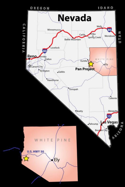
Figure 4-1 Property Location
| September 1, 2011 | 10 | |
|
Midway Gold Corp.
Pan Gold Project Updated Mineral Resource Estimate
|
Property Description and Location
NI 43-101 Technical Report
|
|
4.2
|
Mineral Tenure, Agreements, and Exploration Permits
|
|
4.2.1
|
Mineral Rights
|
The Pan Project consists of 550 contiguous, active, unpatented lode mining claims covering portions of Sections 12 through 15, 22 through 27, and 34 through 36, T17N, R55E; portions of Sections 19, 29, and 30, T17N, R56E; portions of Sections 1 through 3, 10 through 15, 22, and 23, T16N, R56E; and portions of Sections 6 and 7, T16N, R56E, as shown on Figure 4-2.
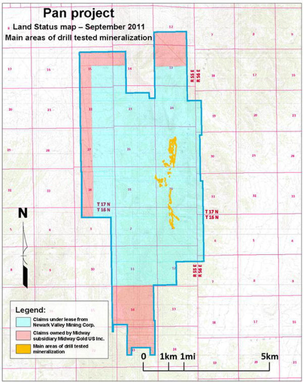
Figure 4-2 Claim Boundary
| September 1, 2011 | 11 | |
|
Midway Gold Corp.
Pan Gold Project Updated Mineral Resource Estimate
|
Property Description and Location
NI 43-101 Technical Report
|
The unpatented lode claims were individually surveyed at time of location. Claim maps filed with the BLM and White Pine County are kept active through payment of an annual maintenance fee due each August 31. A complete listing of the claims on file with the BLM and White Pine County is available upon request.
Newark Valley Mining Agreement
Pursuant to acquisition of the Pan Nevada Gold Corporation (PNV) effective April 16, 2007, MGUS acquired a 100% interest in the January 7, 2003 mineral lease agreement by and between Pan Nevada Gold Corporation (formerly Castleworth Ventures, Inc.) and Newark Valley Mining Corp. (NVMC), derivative successor in interest to The Lyle F. Campbell Trust (LFC Trust). On or before January 5 of each year, PNV must pay an advance minimum royalty of the greater of US$60,000 or the US dollar equivalent of 174 ounces of gold valued by the average of the London afternoon fixing for the third calendar quarter preceding January 1 of the year in which the payment is due. All minimum advance royalties will be creditable against a sliding scale gross production royalty of between 2.5% and 4% (see Table 4-1 below).
If the total amount of gross production royalty due NVMC in any calendar year exceeds the advance minimum royalty due within that year, PNV can credit all un-credited advance minimum royalties paid in previous years against 50% of the gross production royalty due NVMC within that calendar year. Ten claims are also subject to an overriding 1% Net Smelter Royalty (NSR) royalty payable to a third party.
PNV must incur a minimum of US$65,000 per year work expenditures, including claim maintenance fees, during the term of the mining lease.
Table 4-1 Pan Royalty Schedule
|
Price of Gold
|
Percentage
|
|
To and including $340.00/oz
|
2.5%
|
|
From $340.00/oz to $450.00/oz
|
3.0%
|
|
$450.00/oz and greater
|
4.0%
|
(Source: Midway Gold US Inc.)
The original lease encompassed 98 claims and established a 1-mile area of interest within which all new claims located by PNV or an affiliate are subject to the lease agreement. As noted, 10 PA claims are subject to the 1% NSR overriding royalty. PNV (or its predecessors) expanded the claim holdings within the area of interest to a total of 429 unpatented claims.
| September 1, 2011 | 12 | |
|
Midway Gold Corp.
Pan Gold Project Updated Mineral Resource Estimate
|
Property Description and Location
NI 43-101 Technical Report
|
Additional Claims
Over the years, MGUS has staked 121 additional unpatented claims (56 NC, 53 GWEN, PC and REE claim blocks), within and adjacent to the Pan property that are without royalty burden and are not subject to the NVMC area of interest.
|
4.3
|
Environmental Liabilities
|
The BLM prepared an Environmental Assessment (EA) for exploration activities on the Pan property in 2004. This evaluation, conducted as part of the Plan of Operations (POO) process to permit surface disturbance resulting from exploration activities, produced a Finding of No Significant Impact (FONSI). Although the BLM found no significant environmental impact during the EA, the associated scoping process identified air quality, soils, vegetation, wildlife (migratory birds), grazing, wild horses, cultural resources, visual resources, and hazardous/solid wastes as potential areas of concern.
An Exploration POO Amendment describing additional exploration activities was submitted to the BLM by MGUS in 2010, triggering the NEPA process. The POO Amendment includes an additional 75 acres of disturbance and construction of a new access road. Based on BLM scoping, issues of concern for additional exploration include cultural resources, migratory birds, sage grouse, wildlife, vegetation, paleontology, soils, recreation, and visual resources. The draft EA prepared to address these issues did not identify any significant impacts. The draft EA was made available for public comment in March 2011 and a FONSI was signed in July 2011.
Baseline studies to support a potential Mining POO have been initiated and are ongoing. To date, soils, vegetation, and wildlife baseline surveys have been completed. No threatened and endangered or special status species plants were found in the proposed areas of exploration or road construction. Sage grouse are a special status wildlife species present in the vicinity of the existing access road. A new road designed to avoid existing sage grouse leks has been permitted, and its location approved by the BLM and the Nevada Division of Wildlife (NDOW).
Based on the results of the 2004 EA, an Environmental Impact Statement (EIS) will likely need to address the following issues prior to project development:
|
|
·
|
Potential impacts to local sensitive species: sage grouse, white sage, pygmy rabbits, and migratory birds and bats, which have potential to occur within the claim block.
|
|
|
·
|
Potential impacts to segments of the Lincoln Highway/Hamilton Stage Road, Carbonari sites, and other historic/archaeological sites
|
|
|
·
|
Geochemistry
|
|
|
§
|
Gold mineralization in the Pan deposit occurs as sub-microscopic particles disseminated in carbonate and clastic sedimentary rocks. All known mineralization is non-sulphur bearing oxide, and clay and silica alteration are the
|
| September 1, 2011 | 13 | |
|
Midway Gold Corp.
Pan Gold Project Updated Mineral Resource Estimate
|
Property Description and Location
NI 43-101 Technical Report
|
|
|
dominant styles of alteration. Acid rock drainage (ARD) is unlikely based on these conditions, but given the importance of the issue and according to current regulatory requirements, geochemical evaluations of waste materials will need to be completed.
|
The permitting schedule for the Pan Project will be dominated by the NEPA process requirements, which typically take at least one year for baseline studies and public review followed by comment periods for scoping and Draft EIS documents.
The schedule for other required permits will fall within the NEPA time frame and should not impact the overall permit schedule. Examples of other potentially required permits include the following:
|
|
·
|
Nevada Division of Minerals – Mine Registration – requires an approved POO if on Federal land – not approved until after ROD
|
|
|
·
|
Nevada Department of Environmental Protection – Reclamation Permit Application – Requirements are the same as the POO if on Federal Lands.
|
|
|
·
|
Nevada Bureau of Water Pollution Control – Application for Permit to Discharge Process Wastewater
|
|
|
·
|
Nevada Bureau of Water Pollution Control – Groundwater Discharge Permit, if necessary
|
|
|
·
|
Nevada Bureau of Air Pollution Control – Permit to Construct and Operate
|
|
4.4
|
Exploration Permits and Jurisdictions
|
MGUS exploration activities are permitted under the POO approved by BLM in 2004 and the POO Amendment approved by BLM in 2011. MGUS was originally bonded through Pan Nevada at $63,170, which allowed for surface disturbance as a result of exploratory drilling on about 22 acres within the POO boundary. The POO Amendment added approximately 75 acres of new disturbance for access roads and drill pads, and increased the bond amount to a total of $362,696. Approximately 12 acres of ground surface are currently disturbed due to recent exploration activities, and the disturbance and bonding level are updated annually and every three years, respectively, as required by BLM. There are no known historic hard rock or placer mining disturbances on the property.
Portions of the Pan Project were disturbed during previous exploration activity and only some of those areas have been reclaimed. According to the BLM and SRK (2009), MGUS’s responsibility is limited to those disturbed areas that are currently used for exploration activities. MGUS is currently responsible for monitoring and reclamation of active drill roads and drill sites totaling approximately 100 acres.
| September 1, 2011 | 14 | |
|
Midway Gold Corp.
Pan Gold Project Updated Mineral Resource Estimate
|
Accessibility Climate Local Resources Infrastructure & Physiography
NI 43-101 Technical Report
|
|
5
|
ACCESSIBILITY, CLIMATE, LOCAL RESOURCES, INFRASTRUCTURE, AND PHYSIOGRAPHY
|
|
5.1
|
Accessibility, Infrastructure, and Local Resources
|
Access to the Pan property is provided by an unmaintained dirt road that intersects US Highway 50 approximately 17 miles southeast of Eureka, Nevada. It is approximately 7 miles by road from US 50 to the Pan Project site. The property is accessible year-round, but weather conditions occasionally make access and on-site travel difficult during the winter months.
The Pan Project is wholly located on and operations will be contained within MGUS land holdings. Electrical power is available via a power line, which runs adjacent to US 50, approximately 6 miles north of the highway and 14 miles from the project site. Water to support exploration drilling is available from ranch wells located approximately 3 miles to the west of the property. Water rights have been secured to provide for year-round water from the Newark Valley, just west of the mine site, for a term of 25 years.
The town nearest to the project site, Eureka, Nevada, hosts a population of 610 according to 2010 US Census data. Greater Eureka County and White Pine County host area populations of 1,987 and 10,030 respectively, though population is centered primarily in Eureka and Ely, Nevada. Elko, Nevada, population of 18,400, is the nearest city to the project site, and is located approximately 110 miles to the north by road.
Logistical support is available in Eureka, Ely, and Elko, all of which currently support large open pit mining operations. Barrick Gold Corporation currently operates the Ruby Hill Mine near Eureka and the Bald Mountain Mine approximately 50 miles to the north. Quadra Mining operates the Ruth Copper pit near Ely, and large-scale mining by Barrick and Newmont Mining Corporation is ongoing near Elko and Carlin, Nevada to the north. Mining personnel and resources for operations at Pan are expected to be available from Eureka, White Pine, and Elko Counties.
|
5.2
|
Topography, Elevation, Vegetation, and Climate
|
The Pan property is located within the rolling hills of the northern most portion of the Pancake Range. The terrain is gentle to moderate throughout most of the project area, with no major stream drainages. Elevation ranges from 6,400 to 7,500 ft above mean sea level. Local vegetation includes Piñon-Juniper woodlands broken by open areas of sagebrush and grass. No springs are known to exist on the property.
| September 1, 2011 | 15 | |
|
Midway Gold Corp.
Pan Gold Project Updated Mineral Resource Estimate
|
Accessibility Climate Local Resources Infrastructure & Physiography
NI 43-101 Technical Report
|
The local climate is typical for the high desert of east-central Nevada and the Basin and Range province. Climate data shows average annual precipitation of 11.85 inches, average temperatures ranging from 17°F in the winter to 86° F in the summer. Daytime temperatures in Eureka commonly exceed 90°F during the months of July and August (Western Regional Climate Center, 2008).
| September 1, 2011 | 16 | |
|
Midway Gold Corp.
Pan Gold Project Updated Mineral Resource Estimate
|
History
NI 43-101 Technical Report
|
|
6
|
HISTORY
|
|
6.1
|
Exploration History
|
Mr. Lyle Campbell discovered the Pan deposit while prospecting in 1978, when he encountered gold-bearing jasperoid, now referred to as Campbell Jasperoid. Mr. Campbell staked 147 original unpatented mining claims, and transferred ownership of the claims to the LFC Trust in 1986. The LFC Trust was bought out in 2008 and is now owned by NVMC.
Several companies have conducted exploration on the property since 1978. The following paragraphs summarize exploration activities at Pan based on information provided in previously issued technical reports:
|
|
·
|
Mr. Campbell leased his claims to Amselco in 1978. The majority of drilling exploration carried out by Amselco took place in North Pan.
|
|
|
·
|
In 1986, Hecla conducted a drilling exploration program in the central portion of the Pan property.
|
|
|
·
|
Echo Bay leased the claims in 1987 and completed an exploration drilling program that resulted in the discovery of gold mineralization at South Pan.
|
|
|
·
|
The Pan property was explored under a joint venture between Alta Gold and Echo Bay from 1988 through 1991. Drilling was conducted in both North and South Pan, in conjunction with geologic mapping, geochemical sampling, and an induced polarization geophysical survey. The Alta Bay joint venture initiated studies in support of mining development, including an archaeological survey, additional metallurgical test work, and preliminary mineral reserve calculations and mine designs.
|
|
|
·
|
Alta Gold retained ownership of the Pan Project after dissolution of the joint venture until 1992. Drilling exploration was reported, but the associated holes have not been validated and are not included in the modern day resource database.
|
|
|
·
|
In 1993, Southwestern Gold Corporation completed drilling exploration on a small section of claims that they held at that time west of North Pan. The associated drill hole collars have been identified in the field, but no other information has been validated and these holes are not included in the modern resource database.
|
|
|
·
|
The Pan Project was dormant from 1993 until 1999, when Latitude leased the property from LFC Trust. Between 1999 and 2001, Latitude explored the property as part of a joint venture with Degerstrom. Geologic mapping and outcrop and soil sampling were completed under the joint venture, as was drilling and metallurgical testing.
|
| September 1, 2011 | 17 | |
|
Midway Gold Corp.
Pan Gold Project Updated Mineral Resource Estimate
|
History
NI 43-101 Technical Report
|
|
|
·
|
Latitude drilling focused primarily on North and South Pan mineralization, but also resulted in the discovery of mineralization in the modern day Syncline and Black Stallion target areas of Central Pan. Latitude terminated the joint venture with Degerstrom in mid-2001, and joint ventured the project to Metallica later that year. From LFC Trust files, it appears that Metallica focused on thermal imagery and lineament study of satellite data over the Pan area. No additional subsurface exploration work was completed. The LFC Trust terminated the lease agreement with Latitude in 2002, citing Latitude’s inability to meet financial obligations.
|
|
|
·
|
Castleworth Ventures. Inc. leased the Pan claims in January 2003. The company completed drilling exploration and conducted geologic mapping, sampling, metallurgical test work, and resource estimation. On April 16, 2007, Pan Nevada Gold Corporation (formerly Castleworth Ventures, Inc.) was acquired by MGUS.
|
|
|
·
|
Since acquiring the Pan Project in 2007, MGUS has completed 209 holes, of which 195 were reverse circulation and 15 diamond core drill holes for a total of 95,481 ft. Drilling efforts have generally focused on expanding known mineralization, but also include confirmation drilling and exploration drilling in several potential target areas on the Pan property. In addition to drilling exploration, MGUS has completed geologic mapping, soil and outcrop sampling, and gravity survey.
|
|
6.2
|
Historical Resource and Reserve Estimates
|
Historical resource and reserve estimates are described in detail in the 2005 report produced by Mine Development Associates (MDA). These resource and reserve estimates have not been verified, are not considered reliable, are not relevant to the updated mineral resource presented in this report, and are mentioned here for historical completeness only.
| September 1, 2011 | 18 | |
|
Midway Gold Corp.
Pan Gold Project Updated Mineral Resource Estimate
|
Geological Setting and Mineralization
NI 43-101 Technical Report
|
|
7
|
GEOLOGICAL SETTING AND MINERALIZATION
|
|
7.1
|
Regional Geology
|
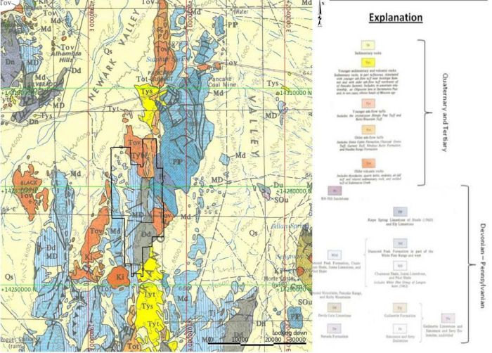
The Pan property is located in the core of the northern portion of the Pancake Range of east-central Nevada. The Pancake Range is part of the Basin and Range Province, a large physiographic region characterized by a series of normal faults expressed as a sequence of north-south trending narrow mountain ranges separated by flat, arid valleys. The Pancake Range is approximately 85 miles long and 8 to 10 miles wide and is composed of Paleozoic carbonate and clastic sedimentary rocks, Cretaceous igneous intrusives, and Tertiary volcanics. A regional geologic map of the northern Pancake Range is presented as Figure 7-1.
| September 1, 2011 | 19 | |
|
Midway Gold Corp.
Pan Gold Project Updated Mineral Resource Estimate
|
Geological Setting and Mineralization
NI 43-101 Technical Report
|
(Smith, 1976)
Figure 7-1 Regional Geology, Pancake RangeLocal Geology
| September 1, 2011 | 20 | |
|
Midway Gold Corp.
Pan Gold Project Updated Mineral Resource Estimate
|
Geological Setting and Mineralization
NI 43-101 Technical Report
|
The Pan property is bounded to the east and west by the Newark Valley. Devonian, Carboniferous, and Permian carbonate and clastic sedimentary rocks form the core of the Pancake Range, and are exposed in bedrock outcrop in the project area. A representative stratigraphic section is presented as Figure 7-2.
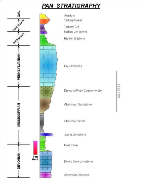
Figure 7-2 Pan Stratigraphy
A Cretaceous intrusion of quartz monzonite is present just south of the Pan Project area and a quartz monzonite sill intrudes along an east-west fault in the south central portion of the property. These intrusives are assumed to be age related to the Seligman and Monte Cristo stocks, which outcrop in the Mount Hamilton area to the east of the Pan property. The Seligman and Monte Cristo stocks may have provided the heat source for the Pan mineral deposits. Post
| September 1, 2011 | 21 | |
|
Midway Gold Corp.
Pan Gold Project Updated Mineral Resource Estimate
|
Geological Setting and Mineralization
NI 43-101 Technical Report
|
mineral Tertiary volcanic rocks, including basalt and quartz latite airfall tuff, nonconformably cap the Devonian to Permian sedimentary bedrock geology in the vicinity of the Pan Project.
The Devonian to Permian carbonate and clastic sedimentary rocks of the Pan property are cut by the Pan fault, a steeply west dipping normal fault that trends north-south. Post-mineral Tertiary volcanic rocks nonconformably overlie the faulted Devonian through Permian sedimentary units.
|
7.2
|
Property Geology
|
The geology of the Pan property is dominated by Devonian to Permian carbonate and clastic sedimentary rocks cut by the Pan fault, a steeply west dipping normal fault that trends north-south. The Pan fault juxtaposes gently west dipping sedimentary units on the west side of the fault, and steeply northeast dipping sedimentary units on the east side. Post-mineral Tertiary volcanic rocks nonconformably overlie the faulted Devonian through Permian sedimentary units. Individual lithologic units identified at the project site are described below, from oldest to youngest.
|
7.2.1
|
Lithological Units
|
Simonson Dolomite (Ds) - Devonian
The Simonson Dolomite is the lowermost lithologic unit intersected by drilling at the Pan property. This unit is not exposed on the surface. Thickness ranges from 500 to 1,300 ft thick in White Pine County (Smith, 1976) but only the top portion of the dolomite has been drilled at South Pan. The dolomite is a light gray, massively bedded unit.
Devils Gate Limestone (Dd) - Late Devonian
The oldest lithologic unit exposed in the northern Pancake Range is the Late Devonian Devil’s Gate Limestone. This unit is massive to thinly bedded, medium to dark gray, fine to coarse grained limestone. Thickness of the unit ranges from about 1000 ft to 2500 ft locally. The Devil’s Gate Limestone is the secondary host of gold mineralization at the Pan property.
Pilot Shale (MDp) - Late Devonian to Early Mississippian
The Pilot Shale has an upper series of thinly interbedded dolomitic and calcareous siltstone and silty shale, and a lower section of more thickly bedded calcareous siltstone with local limestone beds. The unit ranges in thickness from about 300 to 900 ft, but locally thickens structurally along the Pan fault. Silicified and argillized Pilot Shale is the primary host of gold mineralization at the Pan property.
Joana Limestone (Mj) - Mississippian
The Joana Limestone is a gray, medium grained, unevenly bedded limestone with abundant fossil fragments and detrital limestone interbeds. Reported fossil types include echinoderm, bryozoans, foraminifera, algae, and crinoids. Locally, light brown calcareous sandstone is
| September 1, 2011 | 22 | |
|
Midway Gold Corp.
Pan Gold Project Updated Mineral Resource Estimate
|
Geological Setting and Mineralization
NI 43-101 Technical Report
|
present at the base of the unit. Thickness of the Joana Limestone is typically less than 150 ft at the Pan property, though the total thickness reportedly ranges from 90 to 500 ft throughout the county (Smith, 1976).
Chainman Shale (Mc) - Mississippian
The Chainman Shale consists of dark gray to black shale with thin interbeds of olive gray silty shale and siltstone. Thickness of the unit ranges from 1000 to 2000 ft (Smith, 1976) and is about 1000 ft at the Pan property.
Diamond Peak Formation (Md) - Mississippian
The Diamond Peak Formation consists of medium beds of coarse grained, quartz-rich sandstone and olive gray siltstone overlain by thick to massive conglomerate. Thickness of the Formation ranges from less than 1,000 to 3,700 ft, and is about 2400 ft in the Pan Project area.
Ely Limestone (Pe) - Pennsylvanian
The Ely Limestone is a medium bedded, coarsely crystalline, medium gray limestone with local interbeds of siltstone and chert. Thickness ranges from 1800 to 3000 ft, and averages about 2000 ft in the Pancake Range.
Rib Hill Siltstone - Permian
The Rib Hill Siltstone is a thinly bedded, quartz-rich, calcite-cemented siltstone with sandstone interbeds and high iron oxide and carbonate content. Thickness ranges from 800 to 1,400 ft (Smith, 1976). Thickness at the Pan property is unknown as a full section is not exposed, but based on drilling is greater than 600 ft.
Kaibab Limestone - Permian
The Kaibab Limestone is a thick-bedded limestone with reportedly high fossil content. This unit is found in isolated outcrops throughout White Pine County (Smith, 1976) at thicknesses ranging from 50 to 200 ft. True thickness at the Pan property is unknown as only two isolated outcrops of lower Kaibab are exposed.
Intrusives - Cretaceous
In the Mount Hamilton area to the east, both the Seligman and Monte Cristo stock have been age dated at 90.4 to 128.0 million years (Adair and Stringham, 1960). A small intrusive body south of the Pan property, the Pancake stock, was age dated at 108 million years (Smith, 1976). The Pancake stock ranges in composition from quartz monzonite to granodiorite. A quartz monzonite sill intrudes along an east-west fault in the south-central portion of the property.
| September 1, 2011 | 23 | |
|
Midway Gold Corp.
Pan Gold Project Updated Mineral Resource Estimate
|
Geological Setting and Mineralization
NI 43-101 Technical Report
|
Volcanic Units (Tv) - Tertiary
Tertiary volcanics exposed in the northern Pancake Range include a lower (Oligocene) quartz latite airfall tuff (50-200 ft thick) and an upper basalt flow (50-100 ft thick). Infrequent quartz-rich rhyodacite of similar age is present along the northern portion of the Pan property. These units are post mineral and overlie projections of gold mineralization and structure to the north and south of the known gold deposits at Pan.
|
7.2.2
|
Structural Geology
|
The geology of the Pan property is structurally dominated by the north-south trending Pan fault, a high angle reverse fault with possible right lateral offset. Based on drill intercepts and interpretation, the fault dips between 80° to 85° west. On the west side of the fault, Devonian through Mississippian stratigraphy dips 10° to 30° westward. On the east side of the fault, Devonian through Permian stratigraphy dips 65° to 70° to the northeast.
The stratigraphic units on the east side of the Pan fault comprise the southwest limb of a northwest trending syncline. The Pan fault is recognizable in the field by the juxtaposition of younger sedimentary rocks to the east against older sedimentary rocks to the west, and can be tracked north until covered by Tertiary volcanic units. To the south, the Pan fault appears to horsetail with splays arcing to the southeast until covered by post-mineral volcanic units.
The terrain west of the Pan fault is cut by a number of northeasterly trending high angle faults with varying displacement senses. There are also a number of northerly trending faults, which may include high angle, dip-slip faults, and low angle, easterly-directed thrust faults. Thrust faulting reasonably accounts for the multiple repetitions of the Devils Gate Limestone and Pilot Shale, the principal hosts of mineralization.
Considerable breccia is present along and in proximity to the Pan fault and other structures to the west. The breccias host a substantial portion of the gold resource at the Pan Project and are interpreted as dissolution collapse breccia and hydrothermal breccia formed during the mineralizing event. Narrow breccia zones in the Devils Gate Limestone expand in lateral dimensions in the overlying Pilot Shale. The resultant geometry is one of elongate pods of breccia extending along structural trends within the Pilot Shale, with the breccia body necking down at depth in the Devils Gate Limestone. The breccia varies from clast to matrix supported, and contains angular to subrounded sedimentary fragments. Associated crackle breccia, wherein the rock is shattered but fragments remain roughly in place and not rotated, occurs marginal to or as relicts within the breccia bodies, and is altered and mineralized in a manner similar to the dissolution/hydrothermal breccia.
| September 1, 2011 | 24 | |
|
Midway Gold Corp.
Pan Gold Project Updated Mineral Resource Estimate
|
Geological Setting and Mineralization
NI 43-101 Technical Report
|
7.3 Mineralization
The Pan Project can be separated into three general geographic zones: North Pan, South Pan, and Central Pan. Gold mineralization at the Pan Project is encountered in all three zones. Mineralization is both structurally and stratigraphically controlled, occurring primarily in the Pilot Shale along the trend of the Pan fault, within high-angle northwest- and northeast-trending structural zones, and within calcareous shale beds. Collapse breccias in the upper Devil’s Gate Limestone and pipe-like breccia bodies that developed within the Devil’s Gate Limestone below the collapse breccia zones likely acted as conduits for gold-bearing hydrothermal solution.
In South Pan, mineralization occurs in both the Pilot Shale and the Devil’s Gate Limestone, distributed within a broad zone of silicification and calcite veining associated with the Pan fault zone, and appears to be stratabound in limestone and shale along the limbs of an anticline dissected by the Pan fault. The contact between the Pilot Shale and Devil’s Gate Limestone hosts mineralization along strike within both the Central and North Pan zones. These occurrences are described as Carlin-style, epithermal, disseminated, sediment-hosted systems.
Mineralization is primarily hosted in structurally controlled dissolution breccias along sub-vertical faults. Dissolution breccias formed along the Pan fault as well as minor cross faults in both North and South Pan. Wide zones of breccia developed in the Pilot Shale with narrower zones occurring in the Devils Gate Limestone.
Stratigraphically controlled mineralization occurs along argillized contacts between the Pilot Shale and Devils Gate Limestone. Better mineralization along these contacts tends to be hosted within the Pilot Shale. This style of mineralization is less common but is significant in the Wendy area of South Pan and in the Black Stallion and Syncline areas of Central Pan.
Estimation domains were delineated within the North Pan, South Pan, and Central Pan zones based on the style and orientation of mineralization in each area. Both styles of mineralization can be present within the same zone, though one is usually dominant. The search parameters within each domain were restricted to those most appropriate for the dominant style of mineralization.
|
7.3.1
|
Alteration
|
Alteration associated with the Pan deposits is typical of Carlin-style gold systems, and includes silicification, argillization, decalcification, and oxidation. Breccia bodies may be silicified (jasperoid) or argillized and can contain variably altered fragments, including silicified, clay altered, and/or decalcified fragments. The Pilot Shale- Devils Gate Limestone contact may be argillized and/or decalcified.
| September 1, 2011 | 25 | |
|
Midway Gold Corp.
Pan Gold Project Updated Mineral Resource Estimate
|
Geological Setting and Mineralization
NI 43-101 Technical Report
|
Silicification is characterized by multi-phase breccia and passive silica flooding along bedding and structures. Silicification occurs in breccia zones and in the Pilot Shale, and small zones have also been identified in the Devils Gate Limestone. Minor quartz veining has been reported in the North Pan zone, particularly in association with the Campbell Jasperoid.
Clay alteration is generally associated with hydrothermal mineral alteration and carbonate destruction. Clay along faults and bedding is common in both the Pilot Shale and Devil’s Gate Limestone, and is a common matrix of collapse breccias.
Decalcification of both the Devils Gate Limestone and calcareous siltstones of the Pilot Shale is spatially associated with mineralization encountered at Pan. Decalcification results in a sanded, punky texture, especially in lithologic units with high original carbonate content.
Mineralization at Pan occurs in strongly oxidized rock. Oxidation is prevalent throughout each of the zones with strong development of iron oxides (hematite and limonite). Liesegang banding formed in the Pilot Shale in association with oxidation. Sulphide minerals have rarely been described in drill logs at Pan, and are not associated with the gold mineralization.
The bulk of the mineralized area contains elevated barite levels, typically above 0.2%. Hydrothermal barite veins are present in the southeast portion of the property in association with the old Cue Ball Barite Mine, briefly worked in the 1970s.
|
7.3.2
|
Geometry of Mineralization
|
Gold deposits at the Pan Project generally occur as elongate pods in association with structures and dissolution/hydrothermal breccia bodies hosted by the Pilot Shale and, to a lesser extent, the Devils Gate Limestone. Gold deposits also occur as more tabular bodies in deposits hosted by altered and mineralized sedimentary horizons. Cross sections typical of the North and South Pan zones are shown on Figures 7-3 and 7-4.
North Pan mineralization is predominantly hosted in breccias developed in the moderately folded Pilot Shale along the Pan fault and other structures to the west. At present, very little mineralization has been identified in the Devils Gate Limestone, in part due to the lack of drilling which intersects the Pilot Shale-Devil’s Gate contact. Mineralization occurs along a north-south trend approximately 5,000 ft long and 500 to 1,000 ft wide. Gold mineralization has been identified to depths up to 650 ft, but remains open at depth and to the north under volcanic cover. An idealized cross section showing relationships of geology and mineralization at North Pan are shown in Figure 7-3.
The Central Pan zone contains mostly sub-horizontal, tabular mineralization hosted along the Pilot Shale- Devils Gate Limestone contact. Mineralization in the Black Stallion and Syncline areas is dominantly hosted in folded and faulted Pilot Shale, but also occurs in Devils Gate
| September 1, 2011 | 26 | |
|
Midway Gold Corp.
Pan Gold Project Updated Mineral Resource Estimate
|
Geological Setting and Mineralization
NI 43-101 Technical Report
|
Limestone. This area of mineralization is relatively small, but there is some potential for expansion with additional drilling.
In the South Pan zone, mineralization has been identified along the north-south trend of the Pan fault for approximately 5,000 ft, ranging in width from 300 to 700 ft. To the east of the Pan fault, sedimentary units dip 30° to 70° to the northeast, with pronounced fault drag against major structures. Gold occurs in breccias composed of shattered and clay altered, decalcified Devils Gate Limestone. Rock types are typically decalcified limestone and, where present, silicified and argillized Pilot Shale. A significant portion of the Pilot Shale at South Pan is eroded away. Mineralization in the Barite area is structurally dominated and mineralization occurs along the Pan fault in breccias of both the Pilot Shale and Devil’s Gate Limestone. Mineralization in the Wendy area is stratigraphically dominated, more tabular in shape, and is controlled by alteration of the Pilot Shale- Devils Gate Limestone contact. Known mineralization in this zone is open to the east and to the south under volcanic cover. An idealized cross section showing relationships of geology and mineralization at South Pan are shown in Figure 7-4.
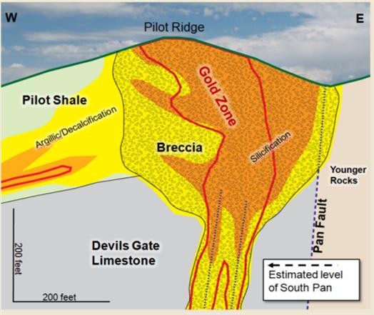
Figure 7-3 East-West Section across North Pan, Looking North
| September 1, 2011 | 27 | |
|
Midway Gold Corp.
Pan Gold Project Updated Mineral Resource Estimate
|
Geological Setting and Mineralization
NI 43-101 Technical Report
|
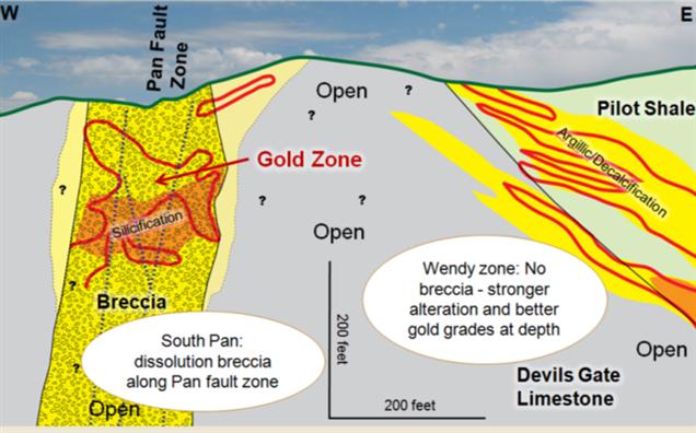
Figure 7-4 East-West Section across South Pan, Looking North
| September 1, 2011 | 28 | |
|
Midway Gold Corp.
Pan Gold Project Updated Mineral Resource Estimate
|
Deposit Types
NI 43-101 Technical Report
|
|
8
|
DEPOSIT TYPES
|
MGUS interprets gold deposits at the Pan Project to be Carlin-style, epithermal, disseminated gold hosted in Devonian and Mississippian sedimentary units. This type of system falls under the general classification of low sulfidation epithermal deposits. Gold particles occur as micron to submicron size disseminations. Visible or coarse gold is not common in this type of deposit, and has not been observed at Pan.
Controls on mineralization in Carlin-style systems and at the Pan Project include both structure and stratigraphy. Gold mineralization is generally distributed along high-angle faults, and in a more tabular fashion subparallel to stratigraphy. Dissolution breccias developed in association with faults at the Pan Project serve as the primary host for gold mineralization. Additional mineralization is hosted in favorable stratigraphy, primarily in the lower Pilot Shale and to a lesser extent, the upper Devil’s Gate Limestone.
Similar type gold deposits in the surrounding area include Bald Mountain, Maverick Springs, Emigrant Springs, and MGUS’s Gold Rock.
| September 1, 2011 | 29 | |
|
Midway Gold Corp.
Pan Gold Project Updated Mineral Resource Estimate
|
Exploration
NI 43-101 Technical Report
|
|
9
|
EXPLORATION
|
Exploration at the Pan Project is a comprehensive effort utilizing a variety of methodologies, including:
|
|
·
|
Geochemical sampling
|
|
|
·
|
Geophysics
|
|
|
·
|
Surface and subsurface geologic mapping
|
|
|
·
|
Drilling within the known resource area
|
|
|
·
|
Drilling on exploration targets
|
|
9.1
|
Previous Operators Exploration Work
|
Previous exploration work includes geologic mapping, metallurgy, geochemical sampling, geophysical surveys, and drilling. Exploration conducted by previous operators is described in detail in previously filed technical reports, including Gustavson’s 2011 Preliminary Feasibility Study.
|
9.2
|
MGUS Exploration Work
|
Since acquiring the Pan property in 2007, MGUS has conducted exploration using a number of different investigative techniques. Drill targets proximal to North and South Pan and additional exploration targets throughout the project area have been identified based on the results of surface geochemical surveys, chip sample analysis, geologic mapping, and geophysical surveys.
|
9.2.1
|
Surface Geochemistry
|
Soil sampling on 100 x 200 and 200 x 200 ft grids was carried out by Pan Nevada (2006) and MGUS (2007 and 2008). This grid covered the majority of the property and consisted of collection and analysis of 9,525 soil samples. Soils were sieved to the -10+80 mesh size fraction and assayed for gold at ALS Chemex. Assay for gold was accomplished by standard fire assay methods on a 30g subsample, and for an additional 50 elements by aqua regia digestion of a 0.5-gram subsample and inductively coupled plasma (ICP) finish.
|
9.2.2
|
Rock Samples
|
Between 2003 and 2008, MGUS and Pan Nevada collected and analyzed a total of 786 surface rock samples. Individual chip samples were collected from outcrops scattered throughout the property, and 10 ft continuous chip samples were collected from Pilot Ridge in the south central portion of North Pan. Samples were collected during geologic reconnaissance traverses, prospect mapping, and target delineation. Rock chips were crushed to 70% passing 2mm with a nominal 250 gram split, pulverized to 85% passing 75μm, and were then assayed by standard fire assay
| September 1, 2011 | 30 | |
|
Midway Gold Corp.
Pan Gold Project Updated Mineral Resource Estimate
|
Exploration
NI 43-101 Technical Report
|
methods by ALS Chemex. Only a small number of samples were analyzed for an additional 50 elements by aqua regia digestion of a 0.5-gram subsample and ICP finish.
|
9.2.3
|
Geologic Mapping
|
Latitude produced a geologic map of the Pan property at a scale of 1:6000 in 2001, focusing on North and South Pan. MGUS completed reconnaissance mapping, scale 1:12000 and more detailed local mapping, scale 1:6000, in 2007 in order to extend map coverage over the entire Pan Project area. This work helped to clarify the geologic setting, identify structural trends, and indicate prospective areas for additional exploration.
|
9.2.4
|
Geophysical Surveys
|
MaGee Geophysical Services conducted a ground gravity survey at the Pan property in 2008. J.L. Wright Geophysics of Spring Creek, Nevada, interpreted the results of the survey, which identified several major structural features and were used to identify target areas for future drilling.
| September 1, 2011 | 31 | |
|
Midway Gold Corp.
Pan Gold Project Updated Mineral Resource Estimate
|
Drilling
NI 43-101 Technical Report
|
|
10
|
DRILLING
|
|
10.1
|
Introduction
|
Gustavson has validated 975 holes drilled at the Pan property since 1978. Historic drilling campaigns carried out by operators other than MGUS account for 766 of the total number of holes. Historic drilling is described in detail in previously filed reports, including Gustavson’s 2010 Preliminary Feasibility Study.
|
10.2
|
Drilling by Midway Gold Corp.
|
As of the effective date of this report, MGUS has drilled a total of 209 holes for a total of 95,444 ft. Of the 209 holes drilled by MGUS, 194 were drilled using reverse circulation, and 15 are diamond core holes. Drilling exploration conducted by MGUS is summarized in Table 10-1, and drill hole distribution is shown on Figure 10-1.
Table 10-1 MGUS Dilling Exporation Summary
|
Exploration Program (Year)
|
Number of Holes Drilled
|
Total Footage
|
Type of Drill Hole
|
|
2007-2008
|
162
|
61,875
|
RC
|
|
2010
|
14
|
5774
|
Core
|
|
2011
|
33
|
27,794
|
RC
|
MGUS completed 33 reverse circulation (RC) holes in 2011. Data from these holes was added to the project database, and was used to update the Pan mineral resource estimate. Drill hole information from drilling completed from January through June 2011, is summarized in Table 10-2.
| September 1, 2011 | 32 | |
|
Midway Gold Corp.
Pan Gold Project Updated Mineral Resource Estimate
|
Drilling
NI 43-101 Technical Report
|
Table 10-2 2011 Drill Hole Summary
|
Area
|
Northing (ft)
|
Easting (ft)
|
Northing (m)
|
Easting (m)
|
Elevation (ft)
|
TD
|
Date Completed
|
Dip
|
Azimuth
|
Purpose
|
|
|
PN11-01
|
S.Dep
|
14270552.22
|
1998752.916
|
4349673.016
|
609221.1072
|
6977.43
|
450
|
1/19/2011
|
-65
|
275
|
Resource
|
|
PN11-02
|
S.Dep
|
14272129.29
|
1998525.103
|
4350153.708
|
609151.6697
|
6831.36
|
560
|
1/29/2011
|
-75
|
270
|
Resource
|
|
PN11-03
|
S.Dep
|
14272211.68
|
1998838.24
|
4350178.82
|
609247.114
|
6796.22
|
570
|
2/3/2011
|
-70
|
270
|
Resource
|
|
PN11-04
|
S.Dep
|
14272182.5
|
1999069.96
|
4350169.926
|
609317.7424
|
6838.91
|
800
|
2/13/2011
|
-90
|
None
|
Resource
|
|
PN11-05
|
S.Dep
|
14271994.47
|
1999047.982
|
4350112.615
|
609311.0435
|
6834.19
|
654
|
2/16/2011
|
-90
|
None
|
Resource
|
|
PN11-06
|
S.Dep
|
14272409.22
|
1998944.925
|
4350239.031
|
609279.6317
|
6791.72
|
680
|
2/23/2011
|
-90
|
None
|
Resource
|
|
PN11-07
|
S.Dep
|
14272420.96
|
1998805.859
|
4350242.609
|
609237.2443
|
6777.94
|
600
|
2/26/2011
|
-90
|
None
|
Resource
|
|
PN11-08
|
S.Dep
|
14271392.6
|
1999364.466
|
4349929.164
|
609407.5081
|
6883.61
|
620
|
3/2/2011
|
-90
|
None
|
Resource
|
|
PN11-09
|
S.Dep
|
14271867.75
|
1999245.998
|
4350073.99
|
609371.3989
|
6880.66
|
750
|
3/12/2011
|
-90
|
None
|
Resource
|
|
PN11-10
|
S.Dep
|
14271663.27
|
1999271.248
|
4350011.665
|
609379.0951
|
6875.71
|
750
|
3/14/2011
|
-90
|
None
|
Resource
|
|
PN11-11
|
S.Dep
|
14273269.31
|
1998896.799
|
4350501.187
|
609264.9629
|
6730.77
|
700
|
3/17/2011
|
-90
|
None
|
Resource
|
|
PN11-17
|
Heap
|
14275730.44
|
1994893.624
|
4351251.341
|
608044.7927
|
6744.17
|
1300
|
3/23/2011
|
-90
|
None
|
Condemnation
|
|
PN11-12
|
S.Dep
|
14273236.97
|
1998700.482
|
4350491.329
|
609205.1253
|
6749.03
|
700
|
3/27/2011
|
-80
|
278
|
Resource
|
|
PN11-13
|
S.Dep
|
14272615.5
|
1998711.867
|
4350301.905
|
609208.5955
|
6772.67
|
600
|
3/30/2011
|
-75
|
133
|
Resource
|
|
PN11-18
|
Heap
|
14274966.78
|
1995829.893
|
4351018.577
|
608330.168
|
6550.17
|
1435
|
3/30/2011
|
-70
|
133
|
Condemnation
|
|
PN11-14
|
S.Dep
|
14273638.6
|
1998727.974
|
4350613.747
|
609213.5049
|
6729.41
|
700
|
4/6/2011
|
-75
|
220
|
Resource
|
|
PN11-15
|
S.Dep
|
14273935.52
|
1998425.131
|
4350704.248
|
609121.1982
|
6753.79
|
780
|
4/10/2011
|
-75
|
90
|
Resource
|
|
PN11-19
|
Heap
|
14274670.99
|
1996129.294
|
4350928.42
|
608421.4257
|
6543.61
|
1450
|
4/10/2011
|
-70
|
130
|
Condemnation
|
|
PN11-16
|
S.Dep
|
14273445.42
|
1998612.7
|
4350554.865
|
609178.3693
|
6755.6
|
700
|
4/13/2011
|
-90
|
None
|
Resource
|
|
PN11-20
|
Heap
|
14274787.34
|
1995969.275
|
4350963.883
|
608372.6518
|
6531.94
|
800
|
4/13/2011
|
-80
|
130
|
Condemnation
|
|
PN11-30
|
S.Pan
|
14273648.92
|
1998516.91
|
4350616.892
|
609149.1725
|
6751.3
|
690
|
4/20/2011
|
-90
|
None
|
Resource
|
|
PN11-31
|
N.Rock Pile
|
14280607.49
|
1997928.55
|
4352737.868
|
608969.84
|
6667.53
|
650
|
4/22/2011
|
-70
|
90
|
Condemnation
|
|
PN11-21
|
Heap
|
14275690.93
|
1996341.796
|
4351239.298
|
608486.1964
|
6581.58
|
1500
|
4/23/2011
|
-80
|
90
|
Condemnation
|
|
PN11-22
|
Heap
|
14276750.67
|
1996346.337
|
4351562.307
|
608487.5805
|
6592.32
|
1500
|
4/26/2011
|
-75
|
90
|
Condemnation
|
|
PN11-32
|
E.Heap
|
14272719.63
|
1992674.556
|
4350333.644
|
607368.4194
|
6393.96
|
850
|
4/26/2011
|
-70
|
90
|
Condemnation
|
|
PN11-33
|
S.Rock Pile
|
14271400.53
|
1996667.375
|
4349931.581
|
608585.4331
|
6687.87
|
900
|
5/4/2011
|
-90
|
0
|
Condemnation
|
|
PN11-23
|
Heap
|
14274621.03
|
1994159.031
|
4350913.192
|
607820.8883
|
6447.69
|
1418.5
|
5/9/2011
|
-70
|
90
|
Condemnation
|
|
PN11-34
|
S.Rock Pile
|
14269746.67
|
1997203.947
|
4349427.484
|
608748.9805
|
6704.7
|
497
|
5/9/2011
|
-70
|
90
|
Condemnation
|
|
PN11-24
|
E.Heap
|
14275327.94
|
1992689.707
|
4351128.658
|
607373.0374
|
6363.27
|
1200
|
5/19/2011
|
-80
|
90
|
Condemnation
|
|
PN11-35
|
Heap
|
14272804.65
|
1995020.974
|
4350359.558
|
608083.609
|
6538.05
|
830
|
5/23/2011
|
-75
|
90
|
Condemnation
|
|
PN11-36
|
Heap
|
14272636.4
|
1996272.06
|
4350308.28
|
608464.939
|
6588.52
|
450
|
5/23/2011
|
-70
|
90
|
Condemnation
|
|
PN11-37
|
Heap
|
14273560.7
|
1994195.49
|
4350590
|
607832
|
6595
|
830
|
6/4/2011
|
-70
|
90
|
Condemnation
|
|
PN11-29
|
Heap
|
14277054.78
|
1992404.15
|
4351655
|
607286
|
6415
|
830
|
6/5/2011
|
-70
|
90
|
Condemnation
|
|
33
|
Total Holes
|
Total:
|
27744.5
|
Total Condemnation
|
16440.5
|
||||||
|
17
|
Resource
holes
|
June
Footage
|
1660
|
Total Resource
|
11304
|
||||||
|
16
|
Condemnation
|
| September 1, 2011 | 33 | |
|
Midway Gold Corp.
Pan Gold Project Updated Mineral Resource Estimate
|
Drilling
NI 43-101 Technical Report
|
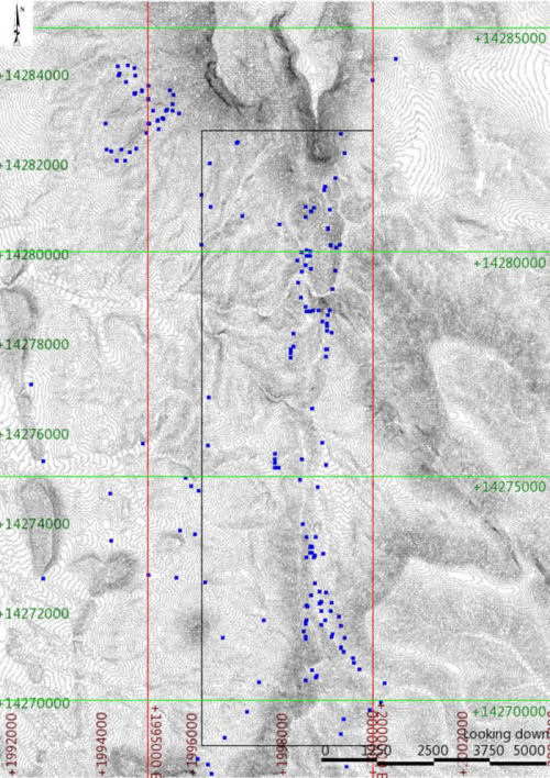
Figure 10-1 Pan Project MGUS Drill Hole Distribution
|
10.2.1
|
Drilling Procedures and Conditions
|
Drilling conditions at Pan are favorable given the moderate terrain and existing road network. Drill sites are prepared by digging a sump and leveling a pad for the drill rig, if necessary. Overland travel is used where possible, and roads are constructed and used only when necessary for safe travel. Holes are generally collared in bedrock and completed above the water table. Historical drilling results indicate that the water table is at least 1,000 ft below ground surface.
RC and rotary methods were used for nearly all drilling at Pan to date. RC drilling was generally carried out using hammer bits (4 ½ to 5 ¾”) to depth, and the use of Tricone bits was limited to a
| September 1, 2011 | 34 | |
|
Midway Gold Corp.
Pan Gold Project Updated Mineral Resource Estimate
|
Drilling
NI 43-101 Technical Report
|
small number of holes where drilling conditions prevented penetration and sample recovery with a hammer bit. These holes were generally cased to depths of 10 to 20 ft.
Most of the core holes drilled at the Pan property were advanced using HQ (2½ inch) size core from ground surface and with no precollars. Core recovery was generally good, but core loss increased in highly fractured and brecciated rock commonly associated with mineralization. Core recovery is discussed in further detail below.
|
10.2.2
|
Drill hole Collar Surveys
|
A digital database of collar locations for the Pan Project was developed by MDA for the 2005 resource estimate. This data was physically compared to all known drill logs to confirm locations and no errors were identified.
A licensed surveyor surveyed all MGUS holes. The UTM NAD 83 coordinate locations of MGUS holes were compared to associated proposed locations, topography, and GPS coordinates to evaluate accuracy and identify errors.
Geologic logs were completed for each drill hole and are compiled in the Pan Project database. Since 2007, MGUS geologists have logged core data directly into Microsoft Excel® spreadsheets using an on-site laptop station during drilling. The logging terminology for formation, lithology, alteration, oxidation, and waste type were preapproved, and any changes to the form required the approval of the project manager. MGUS did collect core samples from the 2010 and 2011 drilling programs. Core samples from previous operators has either been consumed or lost. All project drill logs are printed and catalogued by hole name, together with related drill information, in binders maintained by the company. All collar and drill log information was imported into a secure Microsoft Access® database, stored on the main project computer, and backed up to the corporate server. For security, access to the primary database is limited to the MGUS project manager.
|
10.2.3
|
Down hole Surveys
|
Down hole surveys were completed at Pan for all MGUS drilling.
|
10.2.4
|
Extent of Drilling
|
Drill hole spacing at ground surface ranges from 100 ft to over 400 ft, but is generally on nominal 100 ft centers. The majority of the drill holes (65%) were advanced vertically. Approximately half of the holes drilled at an angle were oriented westerly, and one third of the angled drill holes were oriented easterly. The remaining holes were completed at a variety angles and azimuths. Intercepts equal to or greater than 20 ft grading equal to or greater than 0.010 ozAu/st were encountered in 464 of the total 864 holes drilled at the property since 1978. Most of the mineralization at Pan is hosted in at least moderately steeply dipping structures or
| September 1, 2011 | 35 | |
|
Midway Gold Corp.
Pan Gold Project Updated Mineral Resource Estimate
|
Drilling
NI 43-101 Technical Report
|
stratigraphy, with the exception of bedding- parallel mineralization in the western portions of North Pan, so many of the mineralized downhole thickness do not represent the true thickness of mineralization. With few exceptions, drilled lengths are greater than true thicknesses, and true thickness depends on the angle and azimuth of the drill hole to the orientation of the mineralization being drilled.
|
10.2.5
|
MGUS Data Compilation and Grid Conversion
|
For the 2005 resource estimate, MDA converted the Pan database from a local coordinate system to NAD83, Zone 11 UTM coordinates, expressed in US ft.
|
10.3
|
Sampling Method and Approach
|
The Pan drill hole database includes sample data from reverse circulation, core, and rotary drilling. Drilling was performed by a variety of operators during a total of nine drilling campaigns over a 20-year period. Drill spacing is on nominal 100 ft centers at North Pan and Central Pan, and nominal 165 ft centers at South Pan. Drill spacing tighter than 100 ft centers occurs in some areas of mineralization at North Pan and Central Pan. Most RC and rotary samples (99%) were collected on 5 ft intervals, and all core samples were collected on 5 ft or less than 5 ft intervals. Very little documentation is available on drilling and sampling procedures employed prior to 2004. However, the drilling was conducted by companies experienced in exploration and production.
A review of historic and recent drilling at Pan reveals no reference to groundwater, even in the deepest drill holes in terms of both elevation and MGUS depth. Consistent with the lack of groundwater, there is no significant evidence of MGUS contamination in the RC and rotary drill holes.
MGUS performed RC drilling at Pan in 2007 and 2008, and again in 2011. The drilling was performed wet, with water injection between 1 and 2 gallons per minute. No groundwater was encountered during the drilling, and the deepest hole was completed at a depth of 985 ft.
Cuttings samples were collected every 5 ft by a designated and trained sampler provided by the drilling contractor. Cuttings from each 5 ft sample interval were passed through a cyclone and into a rotary vane splitter with 16 openings. The number of splitter openings was adjusted to maintain a roughly constant sample size of 7 kg. A representative split from the discharge material was placed into a plastic RC chip tray for geological logging. The chip tray was marked with the drill hole name and downhole interval.
RC samples were collected in large micro-pore bags marked with the sample number and suspended from the discharge tube of the splitter. Overflow was minimal because of low water injection rates and lack of groundwater. Nominal sample weight was 5 to 10 kg.
| September 1, 2011 | 36 | |
|
Midway Gold Corp.
Pan Gold Project Updated Mineral Resource Estimate
|
Drilling
NI 43-101 Technical Report
|
RC samples were allowed to drain at the drill site and were taken to a Eureka (2007-2008) or Ely (2010-2011) office facility at the end of each day by MGUS personnel. Samples were stored in secure bins until transported to an assay laboratory in Elko or Winnemucca by certified laboratory personnel.
During the 2010 drilling campaign carried out by MGUS, core was placed in core boxes by the drill crew at the drill site. Core boxes were picked up from the rig daily and transported to the MGUS logging facility. RQD and basic rock strength data was collected before the core was disturbed. Then the core was washed and photographed with color and scale cards included. A geologist selected appropriate intervals for sampling, and logged and photographed the core prior to splitting or sampling. The preferred sample interval and maximum sample length was 5 ft. Smaller intervals were used where significant geological breaks occurred, but not less than 1 ft.
Core was split using a diamond saw where competent. A manual splitter was used for core not suitable for sawing. In soft clay zones, a putty knife was used to split the core. A quarter split was used for assay purposes. The remaining core was sampled for metallurgical and waste rock characterization testing. Skeleton core, a small piece every 2-3 ft, was saved for the core archive. The remainder of the core was sent to the lab.
Chemex picked up the assay samples from the Ely office and transported them to a Nevada prep facility. For quality assurance and quality control, standards and blanks were inserted into the sample stream at a rate of one for every 25 project samples. Commercial SRMs and blanks were acquired from Shea Clark Smith in 2007 and 2008 and from Ore Research & Exploration (Ore Research) of Bayswater North, Australia in 2010 and 2011. SRM’s grading 0.01 opt Au and 0.03 opt Au were alternated with blanks in the sample stream.
| September 1, 2011 | 37 | |
|
Midway Gold Corp.
Pan Gold Project Updated Mineral Resource Estimate
|
Sample Preparation Analyses and Security
NI 43-101 Technical Report
|
|
11
|
SAMPLE PREPARATION, ANALYSES, AND SECURIITY
|
Based on available assay certificate information, samples collected during the ten drilling campaigns at Pan were analyzed for gold by fire assay (AuFA) and/or gold cyanide extraction assay (AuCN). Gustavson and Dr. Baker consider the sample preparation, security, and analytical procedures to be adequate for use in resource and reserve estimation. Table 11-1 summarizes the type of assay data currently in the database.
Table 11-1 Drill Data by Analytical Method
|
Company
|
Number AuFA
Determinations
|
Number AuCN
Determinations
|
AuCN/AuFA
Pairs
|
AuCN
Only
|
Percent of Data Represented by
AuCN Data
|
|
Amselco
|
610
|
3,641
|
303
|
3,338
|
84.6
|
|
Hecla
|
121
|
0
|
0
|
0
|
0
|
|
Echo Bay
|
3,980
|
0
|
0
|
0
|
0
|
|
Alta Bay
|
6,288
|
13,318
|
6,284
|
7,034
|
52.8
|
|
Latitude
|
2,874
|
0
|
0
|
0
|
0
|
|
Castleworth/ Pan Nevada
|
13,738
|
254
|
254
|
0
|
0
|
|
Southwest
|
282
|
0
|
0
|
0
|
0
|
|
MGUS
|
26,099
|
1,190
|
1,190
|
0
|
0
|
|
TOTAL
|
53,992
|
18,403
|
8,031
|
10,372
|
19.2
|
|
11.1
|
Sample Preparation and Analysis Procedures
|
RC samples collected by MGUS were processed by ALS Chemex in Elko and Winnemucca, and by SGS Laboratories in Elko, Nevada. At the end of each day shift, all samples were transported to a secure facility in Ely or Eureka, Nevada for storage. Standards and blanks developed and/or purchased by MGUS were included in the sample sets dispatched to the laboratory. At the labs, samples were crushed to 70% passing -6mm, split to 250g using a riffle splitter, then pulverized to 85% passing 75 microns. Pulps were analyzed using 30g fire assay with an AA finish. Higher grade samples (>0.291 ozAu/st) received a gravimetric finish. For samples returning greater than 300 ppb Au, a cyanide leach analysis was performed. A one-hour cyanide digestion was completed on a 30g sample pulp, followed by AA determination of gold content in the pregnant cyanide solution. MGUS data from 9,957 sample intervals with AuFA determinations, and 1,035 sample intervals with paired AuCN information, are included in the Pan database.
| September 1, 2011 | 38 | |
|
Midway Gold Corp.
Pan Gold Project Updated Mineral Resource Estimate
|
Data Verification
NI 43-101 Technical Report
|
|
12
|
DATA VERIFICATION
|
MDA (2005) and AMEC (2008) verified exploration and drilling data through 2007. Both companies found the logs, surveys, and assays in the Pan mineral resource database accurately represent the source documentation. MGUS did a complete check of the Pan database in 2007; MGUS reinterpreted drill logs and created new interpretations of geology and alteration on cross sections in 2010 and 2011. Gustavson generated a new model based on the updated geologic sections including lithology and alteration.
MGUS personnel verified exploration data collected after January 1, 2008, including checking logs, surveys, and assays. 100% of the 2008 data matches the original information, constituting an error of less than 0.01%. Gustavson independently verified exploration data collected from 2009 through the effective date of this report, September 1, 2011, by checking logs and assay data against core samples, field checking survey data, and comparing assay data reported by MGUS to laboratory assay certificates. Gustavson finds the quality of data collected to date adequate for use in estimating the mineral resources of the Pan Project.
|
12.1
|
Check Assays
|
In 2007, MGUS conducted a rig duplicate program, collecting a duplicate sample from most of the holes completed during the year. Duplicate samples were collected on site approximately every 100 ft. The original assay and duplicate samples were then sent to the same laboratory for analysis. Duplicate samples were split and analyzed using the same procedures as the original sample.
For samples with values less than detection limit (5 ppb), the gold value was set to 0.0. Sample weights were also compared in order to ensure that the duplicates were representative of the original sample. Original sample weights averaged 4.71 kg, compared to 4.66 kg on the duplicates. MGUS utilized two assay laboratories (ALS Chemex and SGS) for this study. The sample statistics are reported by assay laboratory in Table 12-1. The close correlation between the original and duplicate sample results is presented graphically in Figure 12-1.
| September 1, 2011 | 39 | |
|
Midway Gold Corp.
Pan Gold Project Updated Mineral Resource Estimate
|
Data Verification
NI 43-101 Technical Report
|
Figure 12-1 MGUS Rig Duplicates
Based on a total of 316 samples, original assays average 0.0958 ppm Au, and range from 0 to 3.68 ppm Au. Duplicates average 0.0951 ppm Au, ranging from 0 to 1.76 ppm Au.
| September 1, 2011 | 40 | |
|
Midway Gold Corp.
Pan Gold Project Updated Mineral Resource Estimate
|
Data Verification
NI 43-101 Technical Report
|
Table 12-1 Descriptive Statistics of MGUS Duplicate Rig Samples
|
ALS-
Chemex Original (Au ppm)
|
ALS-
Chemex Duplicate (Au ppm)
|
SGS
Original (Au ppm)
|
SGS
Duplicate (Au ppm)
|
All
(Au ppm)
|
All
(Au ppm)
|
|
|
Mean
|
0.1107
|
0.1062
|
0.0650
|
0.0722
|
0.0958
|
0.0951
|
|
Standard Dev
|
0.3323
|
0.2702
|
0.1638
|
0.1683
|
0.2889
|
0.2420
|
|
Min
|
0.000
|
0.0000
|
0.0000
|
0.0000
|
0.0000
|
0.0000
|
|
Max
|
3.6800
|
1.7600
|
1.2700
|
1.1500
|
3.6800
|
1.7600
|
|
Count
|
213
|
213
|
103
|
103
|
316
|
316
|
|
12.2
|
Midway Gold Corp. QA/QC Programs
|
SRK reviewed the QA/QC data from 2007 and 2008 drilling and reported the results of that review in 2009. The following summary is based on information from the 2009 SRK review:
MGUS maintained a regular program of commercial standard reference materials as well as blanks and rig duplicates (2007 only). Standards were purchased from two different companies at increments of 0.55, 1.0, and 2.0 ppm Au. Blanks were obtained from a gravel stockpile located approximately 1 mile north of Highway 50, on Route 879. MGUS employed the following QA/QC protocols during 2007 and 2008 drilling:
|
|
·
|
Rig duplicates, every 100 ft
|
|
|
·
|
Coarse (1/4 inch minus) blank reference material, 1 per 50, minimum 1 per hole
|
|
|
·
|
Standards (-200 mesh) reference material, 1 per 50, minimum 1 per hole
|
A limestone stockpile was used as coarse blank material in 2007 and 2008. In 2007, 115 coarse blank samples were used, with an average result of 0.0029 ppm Au. Nine blanks returned values of >0.013 ppm Au and were investigated further. Significant gold values were not returned in the sample assays from seven holes, and these samples were not rerun. The remaining two holes were reanalyzed for gold, along with a fresh blank sample.
In 2008 a different portion of the limestone stockpile was used as a source for the coarse sample blanks. These samples returned anomalous gold results (>0.030 ppm Au) and use of the blanks was discontinued until a better blank control could be located. Commercial blank material was obtained and used during the 2010 and 2011 drilling programs.
Industry standards were obtained and submitted blindly with drill samples. Three standards at a 2.0 ppm, 1.0 ppm, and 0.55 ppm threshold were utilized. Values within +1 standard deviation
| September 1, 2011 | 41 | |
|
Midway Gold Corp.
Pan Gold Project Updated Mineral Resource Estimate
|
Data Verification
NI 43-101 Technical Report
|
were considered valid and accepted into the database. Values greater than +1 std were further investigated and either reanalyzed or accepted into the database, as appropriate. The 2.0 ppm standard was frequently found to be outside of the +1 std, and use of the 2.0 ppm threshold was discontinued in mid-2007.
Based on the protocol employed by MGUS and the standard/blank assay results, Gustavson finds the quality of the assays completed in 2007 and 2008 acceptable.
Gustavson reviewed sampling and assaying protocols from the 2010 and 2011 drilling programs. Standards, blanks, and duplicates are inserted into the sample numbering scheme at rates of 4%, 3%, and 3%, respectively. Standard sample assay results are analyzed under the guidelines outlined above. Analysis of laboratory quality control and MGUS quality assurance analytical results is conducted in concert with receipt of analytical results from the laboratory, and an inter-laboratory check assay program is carried out to ensure no systematic bias between or among the commercial laboratories. Gustavson finds MGUS’s QA/QC procedures and protocols satisfactory according to current industry standards.
|
12.3
|
Twin Hole Study
|
Two twin holes were drilled by MGUS as part of the QA/QC program. Two RC holes, PN11-01 and PN11-02, were drilled as twins to two diamond core holes, PN10-01C and PN10-10C, respectively. In order to compare the diamond core holes (assayed at varying intervals) with the RC holes (assayed at regular 5 ft intervals), the diamond core hole assay data were composited to 5 ft intervals. Initial comparisons of grade versus depth for each set of holes were dominated by variability over the 5 ft intervals; so all holes were composited sliding downhole at 25 ft intervals to smooth out these effects.
Drill holes PN10-01C and PN11-01 show favorable correlation in a grade versus depth comparison (Figure 12-2). This comparison is useful in showing that higher-grade zones occur at similar depths in both holes. Both holes are lithologically similar, being logged as mostly solution breccia of the Devils Gate Limestone. The generally higher grades in PN11-01 in the interval from ~140 ft to ~270 ft may be due to lithologic variations or due to the natural variability of grade in the system.
| September 1, 2011 | 42 | |
|
Midway Gold Corp.
Pan Gold Project Updated Mineral Resource Estimate
|
Data Verification
NI 43-101 Technical Report
|
Figure 12-2 Grade vs. Depth Comparison 1
Drill holes PN10-10C and PN11-02 also show good correlation in a grade versus depth comparison. Again, both holes are logged as mostly solution breccias of the Devils Gate Limestone. Higher grading zones occur at similar depth intervals in both holes, suggesting some lateral continuity. Correlation is particularly strong in the ~200 ft to 400 ft interval. The RC hole again shows generally higher assay values.
| September 1, 2011 | 43 | |
|
Midway Gold Corp.
Pan Gold Project Updated Mineral Resource Estimate
|
Data Verification
NI 43-101 Technical Report
|
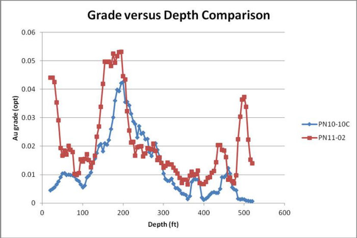
Figure 12-3 Grade vs. Depth Comparison 2
| September 1, 2011 | 44 | |
|
Midway Gold Corp.
Pan Gold Project Updated Mineral Resource Estimate
|
Mineral Processing & Metallurgical Testing
NI 43-101 Technical Report
|
|
13
|
MINERAL PROCESSING AND METALLURGICAL TESTING
|
Extensive metallurgical testing has been conducted on samples from the Pan Project. The results of historic metallurgical testing are discussed in detail in previously filed technical reports, including Gustavson’s 2011 Preliminary Feasibility Study.
Metallurgical analysis of fresh core samples and trench samples collected in 2010 was initiated in December 2010 by MGUS, and is conducted by Resource Development Inc. (RDi). The primary objective of this analysis is to generate sufficient metallurgical data for use in Preliminary Feasibility and Feasibility Studies. Data from the 2010 test program is discussed in detail in Gustavson’s 2011 Preliminary Feasibility Study. Metallurgical analysis was conducted on samples from the 2011 drilling program, but the results of that analysis have not yet been reported. The results of the 2011 metallurgical testing program will be included in the upcoming Feasibility Study, expected to be issued in November 2011.
| September 1, 2011 | 45 | |
|
Midway Gold Corp.
Pan Gold Project Updated Mineral Resource Estimate
|
Mineral Resource Estimates
NI 43-101 Technical Report
|
|
14
|
MINERAL RESOURCE ESTIMATES
|
The updated mineral resource estimate reported for the Pan project as of September 1, 2011, was completed by Zachary J. Black, E.I.T., Gustavson Staff Geological Engineer, under the supervision of Terre Lane, Associate Principal Mining Engineer and Donald E. Hulse, P.E., Vice President. The mineral resource was updated for South and Central Pan areas of the deposit. No new drilling or geologic information was available for North Pan, so the mineral resource at North Pan is unchanged from the February 2011 estimate. This mineral resource estimate is compliant with NI 43-101 and CIM Definition Standards.
|
14.1
|
Data Used for the Gold Grade Estimation
|
Gustavson Associates created a 3 dimensional block model for estimating mineral resources at the Pan Project from data provided by MGUS. Drill hole data including collar coordinates, MGUS surveys, sample assay intervals, and geologic logs were provided in a secure Microsoft Access database. Geology surface maps and cross-sections detailing alteration and lithology were also provided in electronic format.
The present database has been updated to include the additional 33 reverse circulation drill holes completed in 2011 by MGUS in Central and South Pan. Four drill holes (PR-53, PN08-15, PN08-16, and PN10-12C) were removed from the database because the collar coordinates could not be validated or because the holes were abandoned.
The Pan drill hole database contains gold assay analytical information on 53,992 sample intervals, with assay results by fire assay and cyanide digestion stored separately. As a subset of this total database, 43,617 samples contain AuFA assay data, and 18,403 contain AuCN assay data. Of the AuCN data, 8,028 are paired with AuFA assay results, providing an indication of associated gold recovery, though at a very fine grind. AuCN data only is available for another 10,375 samples.
Samples without a total gold assay are generally associated with the Amselco and Alta Bay datasets, and for the Alta Bay material data is limited to values below 0.012 ozAu/st on the AuCN determination. In the 2005 MDA report, comparative analysis of AuFA and AuCN data indicates that AuCN analyses are potentially 24% lower than AuFa depending on cyanide solubility of contained gold. All assays below detection limits were set to 0.000 oz/ton, and missing samples were not assigned any value and were not used in the estimation.
|
14.2
|
Density
|
MGUS performed density tests on 194 diamond core samples from both North and South Pan. The test procedure included weighing of the core sample in air, weighing the sample in water, and use of the following calculation:
| September 1, 2011 | 46 | |
|
Midway Gold Corp.
Pan Gold Project Updated Mineral Resource Estimate
|
Mineral Resource Estimates
NI 43-101 Technical Report
|
A = mass of dry specimen in air,
B = mass of specimen in water,
The results are summarized in Table 14-1.
Table 14-1 Core Sample Density Test Results
|
Rock Type
|
Density
t/ft3
|
Tonnage Factor
ft3/ton
|
|
Argillic Shale
|
0.0685
|
14.6
|
|
Unaltered Shale
|
0.0704
|
14.2
|
|
Limestone
|
0.0781
|
12.8
|
|
Breccia
|
0.0794
|
12.6
|
|
Argillic Breccia
|
0.0758
|
13.2
|
|
Silicified Breccia
|
0.0763
|
13.1
|
|
Tertiary Volcanics
|
0.0592
|
16.9
|
|
14.3
|
Methodology
|
Gustavson modeled and estimated the mineral resources by constructing geologic, alteration, and mineral domains from the MGUS cross sections, and geostatistically analyzing the drill data to define the estimation parameters used to estimate gold grades into the 3-Dimensional (3D) block model. Leapfrog 3D® geological modeling software was used to create 3D stratigraphic, alteration and mineral domain solids. MicroModel mining software was used to estimate gold grades.
MGUS defined the structure, stratigraphy, and alteration of the North and South Pan areas of property on 1 in. = 50 ft cross sections spaced 200 ft apart and oriented east-west, to best account for orientation of the deposit. Gustavson combined the MGUS subsurface interpretations with the surface geology to create 3D stratigraphic and alteration models.
Gustavson visually evaluated the assay data on cross-section, and found that while the majority of the mineralization was restricted to the dissolution/hydrothermal breccia there was related contact mineralization in other lithologic domains. Gustavson found that a +0.004 opt grade population represented a continuous zone of mineralization related to the argillic alteration, stratigraphic ore zones, and the breccia zone. A higher grade + 0.008 opt grade population
| September 1, 2011 | 47 | |
|
Midway Gold Corp.
Pan Gold Project Updated Mineral Resource Estimate
|
Mineral Resource Estimates
NI 43-101 Technical Report
|
represented a continuous zone of higher-grade material possibly related to silica flooding within the breccia zone. Grade breaks were added at + 0.002 and + 0.006 opt in order to better model the gradational boundaries of the stratigraphically controlled areas. These grade breaks were used to construct grade domain boundaries representative of the lithology, alteration, and grade of the zone being modeled. The grade domains were used as both soft and hard boundaries designed to replicate the gradational changes identified in the drill hole assay data.
|
14.4
|
Estimation Domains
|
In order to accommodate statistical search parameters appropriate for individual mineralization styles and structural orientations, the block model was divided into several domains. Domains were delineated based on distinguishing characteristics of one or several target areas grouped together. The three zones of the project area, North, Central, and South Pan, were the starting demarcations for building the domains. Each of these zones was then divided into a domain based on the individual characteristics of the area (Figure 14-1).
| September 1, 2011 | 48 | |
|
Midway Gold Corp.
Pan Gold Project Updated Mineral Resource Estimate
|
Mineral Resource Estimates
NI 43-101 Technical Report |
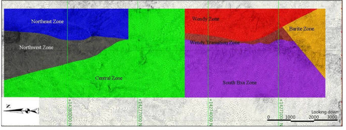
Figure 14-1 Estimation Domains
| September 1, 2011 | 49 | |
|
Midway Gold Corp.
Pan Gold Project Updated Mineral Resource Estimate
|
Mineral Resource Estimates
NI 43-101 Technical Report |
|
14.4.1
|
Creation of Domains
|
|
14.4.1.1
|
North Pan
|
The northeast portion of the North Pan zone was delineated as its own domain, the Northeast domain. This domain is dominated by a structurally controlled solution collapse breccia that occurs adjacent to the Pan fault, and is oriented near-vertically.
The northwest portion of the North Pan zone was delineated as the Northwest domain. Mineralization in these areas is more sub-horizontal and is controlled by alteration along the Pilot Shale- Devils Gate Limestone.
|
14.4.1.2
|
Central Pan
|
The entire Central Pan zone was included in the Central domain. Each of the individual target areas in this zone, namely Black Stallion and Syncline, are characterized by sub-horizontal mineralization along the Pilot Shale- Devils Gate Limestone contact.
|
14.4.1.3
|
South Pan
|
The portion of South Pan adjacent to the Pan fault that contains the South Breccia target area was delineated as the South Breccia domain. This domain is dominated by a structurally controlled solution collapse breccia, and is oriented near-vertically.
The portion of the South Pan zone east of the South Breccia domain was delineated as the Wendy Transition domain. It contains characteristics of the vertical, structurally-controlled South Breccia target area and the easterly dipping, stratigraphically dominated Wendy target area. The data in this domain did not fall cleanly into either target area and was thus assigned as a transitional domain.
The portion of the South Pan zone east of the Wendy Transition domain that contains the Wendy target area was designated the Wendy domain. The Wendy target area was delineated as a separate domain due to dominant stratigraphically controlled mineralization along the Pilot Shale- Devils Gate Limestone contact. The mineralization also has an easterly dip that distinguishes it and warranted a custom search ellipse to better fit the data.
The portion of South Pan south of the South Breccia domain that contains the Barite target area was designated as the Barite domain. This domain is characterized by the same near-vertical, structural dissolution breccia dominated mineralization as the South Breccia domain, but here the breccia arcs to the southeast. The change in strike of the breccia warranted a delineated domain to better align the search ellipse along strike (Figure 14-2).
| September 1, 2011 | 50 | |
|
Midway Gold Corp.
Pan Gold Project Updated Mineral Resource Estimate
|
Mineral Resource Estimates
NI 43-101 Technical Report |
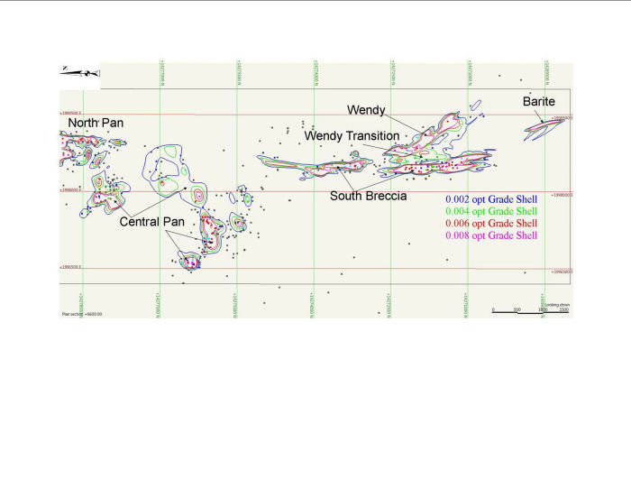
Figure 14-2 South and Central Pan Grade Shells at Bench 6600
| September 1, 2011 | 51 | |
|
Midway Gold Corp.
Pan Gold Project Updated Mineral Resource Estimate
|
Mineral Resource Estimates
NI 43-101 Technical Report |
|
14.4.2
|
Grade Shell Estimation
|
Each domain in the North Pan zone consists of two grade boundaries representing 0.004 and 0.008 opt, and each domain in the Central and South Pan zones consists of four grade boundaries representing 0.002, 0.004, 0.006 and 0.008 opt gold assays. Figure 14-1 illustrates the location of these domains on the footprint of the project.
There are potential bias problems with cyanide solution assays appearing lower than the corresponding fire assays. Cyanide solution samples were used to estimate data outside of the interpreted mineralized zones in order to limit their effect on the overall grade of the resource model, as they can be up to 24% lower than the corresponding fire assay. In the North Pan zone this was done by limiting the use of the AuCN data to the inferred resource estimation. In the Central and South Pan zones this was done by estimating the blocks outside of the + 0.004 opt grade shell using all of the available data.
|
14.4.2.1
|
North pan
|
No additional drilling has been completed in the North Pan zone, and the resource estimate published in the Pan Gold Project Pre-Feasibility Study NI 43-101 Technical Report dated April 4th, 2011 is still valid and was used for this report. The previous North Pan resource estimate included a limited portion of the Syncline target area, which has been reallocated to the Central Pan zone. The Northeast and Northwest domain estimates are not impacted by the addition of the Central Pan zone to the resource.
|
14.4.2.2
|
Central and South pan
|
This updated resource estimate is based in part on additional data from 33 new reverse circulation drill holes in the South Pan zone, and newly interpreted geology of the Central Pan zone. The two separate block models used in the previous resource estimate were extended and combined across Central Pan to create a single coherent block model for use in the current estimate. Grade boundaries in the Central and South Pan domains were estimated at 0.002, 0.004, 0.006 and 0.008 opt gold assay values. The estimation below the 0.004 opt was done using all available assay data (both AuFA and AuCN), while those at + 0.004, + 0.006, and + 0.008 utilize only the AuFA data.
The grade boundary solids were used to code the block model and drill hole assays to the domains. Blocks codes were restricted to the grade boundaries on either side of that being estimated, i.e. blocks within the 0.004 grade boundary used the closest samples from within the + 0.002, + 0.004, and + 0.006 boundary for grade estimation. Summary statistics of the coded drill hole samples are presented in Table 14-2. Statistically the Barite zone is not differentiated from the South Breccia Zone as it is the same style mineralization with a different orientation.
| September 1, 2011 | 52 | |
|
Midway Gold Corp.
Pan Gold Project Updated Mineral Resource Estimate
|
Mineral Resource Estimates
Table of Contents NI 43-101 Technical Report
|
Table 14-2 Pan Project Raw Assay Summary Statistics Au ≥ 0.0001 opt
|
South and Central Pan Sample Assay Summary Statistics Au ≥ 0.0001 opt
|
|||||
|
Mineral Domain
|
Sample
Count
|
Maximum
|
Mean
|
Median
|
Variance
|
|
n
|
opt
|
opt
|
opt
|
opt
|
|
|
Central
|
2277
|
0.015
|
0.001
|
0.000
|
0.000
|
|
Central 0.002
|
1018
|
0.026
|
0.002
|
0.001
|
0.000
|
|
Central 0.004
|
614
|
0.049
|
0.004
|
0.002
|
0.005
|
|
Central 0.006
|
444
|
0.067
|
0.006
|
0.003
|
0.007
|
|
Central 0.008
|
1190
|
0.171
|
0.017
|
0.011
|
0.020
|
|
South Pan Bxa
|
1469
|
0.010
|
0.001
|
0.001
|
0.000
|
|
South Pan Breccia 0.002
|
944
|
0.032
|
0.003
|
0.002
|
0.000
|
|
South Pan Breccia 0.004
|
473
|
0.053
|
0.005
|
0.004
|
0.000
|
|
South Pan Breccia 0.006
|
575
|
0.048
|
0.007
|
0.005
|
0.000
|
|
South Pan Breccia 0.008
|
4011
|
0.254
|
0.022
|
0.016
|
0.000
|
|
Wendy Transition
|
814
|
0.015
|
0.001
|
0.001
|
0.000
|
|
Wendy Transition 0.002
|
537
|
0.032
|
0.003
|
0.002
|
0.000
|
|
Wendy Transition 0.004
|
178
|
0.052
|
0.005
|
0.003
|
0.000
|
|
Wendy Transition 0.006
|
104
|
0.031
|
0.006
|
0.004
|
0.000
|
|
Wendy Transition 0.008
|
769
|
0.292
|
0.018
|
0.011
|
0.001
|
|
Wendy
|
1311
|
0.010
|
0.001
|
0.000
|
0.000
|
|
Wendy Zone 0.002
|
540
|
0.022
|
0.003
|
0.002
|
0.000
|
|
Wendy Zone 0.004
|
392
|
0.028
|
0.005
|
0.004
|
0.000
|
|
Wendy Zone 0.006
|
331
|
0.035
|
0.007
|
0.005
|
0.000
|
|
Wendy Zone 0.008
|
769
|
0.292
|
0.018
|
0.011
|
0.001
|
| September 1, 2011 | 53 | |
|
Midway Gold Corp.
Pan Gold Project Updated Mineral Resource Estimate
|
Mineral Resource Estimates
NI 43-101 Technical Report |
|
14.5
|
Compositing
|
Twenty-foot downhole composites were created from the gold assays and confined to each of the domain solids and grade shells. The composites were then used for the grade capping analysis and variography for each domain solid. Table 14-3 presents the composite data for each domain.
Table 14-3 Domain Composite Data
|
South and Central Pan Composite Assay Summary Statistics Au ≥ 0.0001 opt
|
|||||
|
Mineral Domain
|
Sample
Count
|
Maximum
|
Mean
|
Median
|
Variance
|
|
n
|
opt
|
opt
|
opt
|
opt
|
|
|
Central
|
624
|
0.008
|
0.001
|
0.001
|
0.000
|
|
Central 0.002
|
270
|
0.012
|
0.002
|
0.002
|
0.000
|
|
Central 0.004
|
164
|
0.015
|
0.004
|
0.003
|
0.000
|
|
Central 0.006
|
113
|
0.019
|
0.006
|
0.005
|
0.000
|
|
Central 0.008
|
310
|
0.152
|
0.017
|
0.013
|
0.000
|
|
South Pan Breccia
|
464
|
0.004
|
0.001
|
0.001
|
0.000
|
|
South Pan Breccia 0.002
|
282
|
0.020
|
0.003
|
0.002
|
0.000
|
|
South Pan Breccia 0.004
|
115
|
0.038
|
0.005
|
0.004
|
0.000
|
|
South Pan Breccia 0.006
|
150
|
0.025
|
0.007
|
0.006
|
0.000
|
|
South Pan Breccia 0.008
|
1046
|
0.017
|
0.021
|
0.018
|
0.000
|
|
Wendy Transition
|
346
|
0.004
|
0.001
|
0.000
|
0.000
|
|
Wendy Transition 0.002
|
148
|
0.011
|
0.003
|
0.003
|
0.000
|
|
Wendy Transition 0.004
|
97
|
0.010
|
0.005
|
0.004
|
0.000
|
|
Wendy Transition 0.006
|
85
|
0.018
|
0.006
|
0.006
|
0.000
|
|
Wendy Transition 0.008
|
196
|
0.210
|
0.018
|
0.013
|
0.000
|
|
Wendy
|
225
|
0.005
|
0.001
|
0.001
|
0.000
|
|
Wendy Zone 0.002
|
144
|
0.010
|
0.002
|
0.002
|
0.000
|
|
Wendy Zone 0.004
|
42
|
0.018
|
0.005
|
0.004
|
0.000
|
|
Wendy Zone 0.006
|
28
|
0.027
|
0.007
|
0.006
|
0.000
|
|
Wendy Zone 0.008
|
39
|
0.078
|
0.018
|
0.015
|
0.000
|
|
14.6
|
Capping of Assays
|
The following paragraphs summarize information reported by MGUS (2009) and independently verified by Gustavson during the Prefeasibility Study.
Cumulative probability plots were created for 10-foot, 20-foot and 50-foot composites. These plots were completed for each domain and for all of the composites within all zones together.
| September 1, 2011 | 54 | |
|
Midway Gold Corp.
Pan Gold Project Updated Mineral Resource Estimate
|
Mineral Resource Estimates
NI 43-101 Technical Report |
Analysis showed no significant influence of higher-grade samples to the final estimate of grade or tonnage of the deposit.
A similar result was obtained by an analysis that AMEC completed for an internal resource estimate of the Pan deposit (AMEC, May 9, 2008). This analysis was based upon a metal-at-risk Monte Carlo Simulation. For this simulation, two probability distributions are created, each representing the real distribution of the high grade and nominal grades of the deposit. The simulation creates drill hole results for thousands of samples based upon each of the distributions. It then uses the results to estimate a tonnage to be mined from both of the populations on a yearly basis. Based on the results of this analysis, AMEC concluded that less then 1.7% of the metal in the deposit is at risk and that capping of the Pan deposit was not warranted.
Based on the analyses completed by MGUS and by AMEC, no capping was applied to the Pan assay data or composites.
Gustavson generated cumulative frequency plots for each of the newly defined domains to evaluate capping with the additional drilling samples from the 2010 and 2011 drilling programs. No evidence of extreme high grade outliers was found in the analysis, and no capping was applied to the samples or composites used in the resource estimation.
|
14.7
|
Variography
|
Variography analysis was completed for all seven estimation domains to establish the spatial variability of mineralization within each domain. Variography establishes the appropriate contribution that any specific composite should have when estimating a block volume value within a model. This is performed by comparing the orientation and distance used in the estimation to the variability of other samples of similar relative direction and distance. An example of a spherical variogram constructed from the major axis of the South Pan Breccia domain using a “Pairwise Relative” method of organizing of the variance pairs is shown in Figure 14-3.
Variograms were created for both horizontal and vertical orientations within each domain increment of 15° between orientations. Search ellipsoid axis orientations were based on the results of that analysis. The sill and nugget values for each domain were taken from the omni-directional variograms. The resultant variogram parameters are shown in Table 14-4.
| September 1, 2011 | 55 | |
|
Midway Gold Corp.
Pan Gold Project Updated Mineral Resource Estimate
|
Mineral Resource Estimates
Table of Contents NI 43-101 Technical Report
|
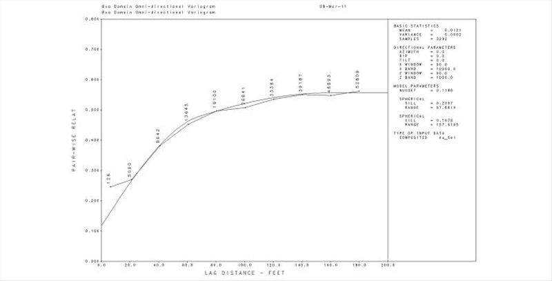
Figure 14-3 A Spherical Variogram for the Major Axis the South Pan Breccia Domain
Table 14-4 Pan Variogram Parameters
|
Primary Axis
|
|||||||
|
North
Breccia
|
North West
|
Central
|
South
Breccia
|
Wendy
Transition
|
Wendy
|
Barite
|
|
|
Strike
|
Isotropic
|
255
|
255
|
0
|
350
|
323
|
340
|
|
Plunge
|
0
|
0
|
-10
|
5
|
0
|
10
|
|
|
Secondary Axis
|
|||||||
|
Dip Direction
|
Isotropic
|
345
|
345
|
270
|
260
|
53
|
250
|
|
Dip
|
0
|
0
|
-85
|
-85
|
-63
|
-85
|
|
|
Model Type
|
Spherical
|
Spherical
|
Spherical
|
Spherical
|
Spherical
|
Spherical
|
Spherical
|
|
C0
|
0.213
|
0.212
|
0.391
|
0.303
|
0.262
|
0.419
|
0.303
|
|
C1
|
0.431
|
0.414
|
0.609
|
0.425
|
0.372
|
0.452
|
0.425
|
|
C2
|
0.356
|
0.374
|
---
|
0.272
|
0.366
|
0.130
|
0.272
|
| September 1, 2011 | 56 | |
|
Midway Gold Corp.
Pan Gold Project Updated Mineral Resource Estimate
|
Mineral Resource Estimates
NI 43-101 Technical Report |
|
Range1
|
68
|
100
|
192
|
72
|
50
|
60
|
72
|
|
Range2
|
158
|
174
|
---
|
210
|
130
|
160
|
210
|
|
14.8
|
Estimation Methodology
|
A Block model was created for the Pan deposit using blocks that are 20 feet wide, 20 feet long and 20 feet high. Each of the blocks was assigned attributes of gold grade, resource classification, rock density, tonnage factor, lithology, alteration, and a grade domain classification. The blocks were then assigned densities and domain assignments as appropriate to assist in estimation.
North Pan
All of the domains were estimated in 3 passes and each block was assigned a classification of measured, indicated, or inferred based on the parameters in Table 14-4. The resource classification of each block was based on a factor of the average sample distance in an anisotropic direction as established by the second structure range (Table 14-3) from the variogram model for the domain being estimated. The measured class utilized a ½ ellipsoid variogram search distance. Indicated was set at a full variogram search distance and inferred was set at 2 times the variogram distance. As an additional requirement, Gustavson limited the measured and indicated estimation data to include only the fire assay intervals. Inferred resource was estimated using all available assay data.
Central and South Pan
All of the domains were estimated by using large search ellipses oriented in the direction of maximum continuity to provide an estimation of the gold grade within every block inside of the grade shells. The resource classification of each block was based on a factor of the closest sample distance in an anisotropic direction as established by the second structure range (Table 14-3) from the variogram model for the domain being estimated. The measured class utilized a ½ ellipsoid variogram search distance. Indicated was set at a full variogram search distance and inferred was set at 2 times the variogram distance. Each domain was estimated using a minimum of 5 composites with no more than 4 composites from a single drill hole. A maximum of 12 composites was allowed to better represent the local variability.
Ordinary Kriging was used to estimate grade for all domains. Estimation parameters for each of the domains are given in Tables 14-5 through 14-7
| September 1, 2011 | 57 | |
|
Midway Gold Corp.
Pan Gold Project Updated Mineral Resource Estimate
|
Mineral Resource Estimates
NI 43-101 Technical Report
|
Table 14-5 Pan Estimation Parameters
|
Domain
|
North Breccia
|
North West
|
||||
|
Measured
|
Indicated
|
Inferred
|
Measured
|
Indicated
|
Inferred
|
|
|
1st Pass
|
2nd Pass
|
3rd Pass
|
1st Pass
|
2nd Pass
|
3rd Pass
|
|
|
Min
|
3
|
3
|
2
|
3
|
3
|
2
|
|
Max
|
8
|
12
|
12
|
8
|
12
|
12
|
|
Max per Hole
|
2
|
2
|
4
|
2
|
2
|
4
|
|
Search Ellipsoid Distance
|
||||||
|
Primary
|
79
|
158
|
316
|
87
|
174
|
348
|
|
Secondary
|
79
|
158
|
316
|
45
|
90
|
180
|
|
Tertiary
|
79
|
158
|
316
|
30
|
60
|
120
|
Table 14-6 Pan Estimation Parameters
|
Domain
|
South Breccia
|
Wendy Transition
|
Wendy
|
||||||
|
Min
|
5
|
5
|
5
|
||||||
|
Max
|
12
|
12
|
12
|
||||||
|
Max per Hole
|
4
|
4
|
4
|
||||||
|
Search Ellipsoid Distance
|
|||||||||
|
Measured
|
Indicated
|
Inferred
|
Measured
|
Indicated
|
Inferred
|
Measured
|
Indicated
|
Inferred
|
|
|
Primary
|
105
|
210
|
420
|
65
|
130
|
260
|
80
|
160
|
320
|
|
Secondary
|
90
|
180
|
360
|
47
|
94
|
188
|
62
|
124
|
248
|
|
Tertiary
|
23
|
46
|
92
|
22
|
44
|
88
|
62
|
124
|
248
|
Table 14-7 Pan Estimation Parameters
|
Domain
|
Barite
|
Central
|
||||
|
Min
|
5
|
5
|
||||
|
Max
|
12
|
12
|
||||
|
Max per Hole
|
4
|
4
|
||||
|
Search Ellipsoid Distance
|
||||||
|
Measured
|
Indicated
|
Inferred
|
Measured
|
Indicated
|
Inferred
|
|
|
Primary
|
105
|
210
|
420
|
96
|
192
|
384
|
|
Secondary
|
90
|
180
|
360
|
66
|
132
|
264
|
|
Tertiary
|
23
|
46
|
92
|
65
|
130
|
260
|
| September 1, 2011 | 58 | |
|
Midway Gold Corp.
Pan Gold Project Updated Mineral Resource Estimate
|
Mineral Resource Estimates
NI 43-101 Technical Report
|
|
14.9
|
Estimate Validation
|
The model was validated by examining the blocks with actual drill hole assay data to determine if the estimated blocks fit the geologic parameters of the various domains of the deposit. Both assay and geological constraints were visually examined. A bench plan at an elevation 6600 feet displaying the block model gold content with the composite gold data and grade shells is presented in Figure 14-4.
| September 1, 2011 | 59 | |
|
Midway Gold Corp.
Pan Gold Project Updated Mineral Resource Estimate
|
Mineral Resource Estimates
NI 43-101 Technical Report
|
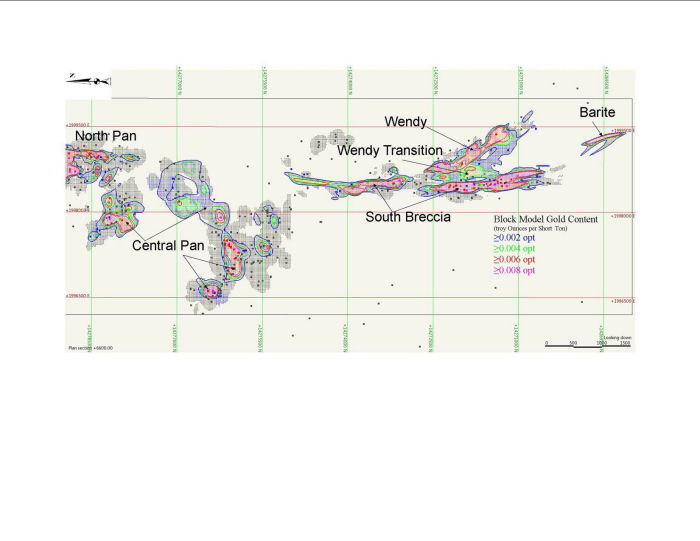
Figure 14-4 Block Model Gold Content of Bench Elevation 6600
| September 1, 2011 | 60 | |
|
Midway Gold Corp.
Pan Gold Project Updated Mineral Resource Estimate
|
Mineral Resource Estimates
NI 43-101 Technical Report
|
|
14.10
|
Mineral Resource Classification
|
The mineral resources at Pan are classified as measured, indicated, and inferred in accordance with CIM Definition Standards for Mineral Resources and Mineral Reserves.
|
14.11
|
Mineral Resource Tabulation
|
The mineral resource estimate is summarized in Tables 14-8 through 14-11. This mineral resource estimate includes all drill data obtained as of September 1, 2011 and has been independently verified by Gustavson.
Table 14-8 North Pan Mineral Resource
|
North Pan Measured Resource
|
|||
|
Cutoff
|
Tons
|
Au Opt
|
oz
|
|
0.008
|
13,994,415
|
0.0168
|
234,844
|
|
0.006
|
15,592,007
|
0.0158
|
245,850
|
|
0.004
|
18,597,319
|
0.0140
|
260,404
|
|
North Pan Indicated Resource
|
|||
|
0.008
|
10,565,126
|
0.0146
|
154,540
|
|
0.006
|
12,702,959
|
0.0133
|
169,135
|
|
0.004
|
17,006,845
|
0.0112
|
189,823
|
|
North Pan Measured plus Indicated Resource
|
|||
|
0.008
|
24,559,541
|
0.0159
|
389,384
|
|
0.006
|
28,294,966
|
0.0147
|
414,985
|
|
0.004
|
35,604,164
|
0.0126
|
450,228
|
|
North Pan Inferred Resource
|
|||
|
0.008
|
122,858
|
0.0112
|
1,376
|
|
0.006
|
233,476
|
0.0091
|
2,129
|
|
0.004
|
511,402
|
0.0067
|
3,427
|
| September 1, 2011 | 61 | |
|
Midway Gold Corp.
Pan Gold Project Updated Mineral Resource Estimate
|
Mineral Resource Estimates
NI 43-101 Technical Report |
Table 14-9 Central Pan Mineral Resource
|
Central Pan Measured Resource
|
|||
|
Cutoff
|
Tons
|
Au Opt
|
oz
|
|
0.008
|
2,329,227
|
0.0146
|
33,991
|
|
0.006
|
2,837,448
|
0.0132
|
37,482
|
|
0.004
|
3,802,537
|
0.0111
|
42,192
|
|
Central Pan Indicated Resource
|
|||
|
0.008
|
1,895,266
|
0.0122
|
23,216
|
|
0.006
|
2,524,520
|
0.0109
|
27,623
|
|
0.004
|
4,053,056
|
0.0086
|
34,885
|
|
Central Pan Measured plus Indicated Resource
|
|||
|
0.008
|
4,224,493
|
0.0135
|
57,207
|
|
0.006
|
5,361,968
|
0.0121
|
65,105
|
|
0.004
|
7,855,593
|
0.0098
|
77,077
|
|
Central Pan Inferred Resource
|
|||
|
0.008
|
240,912
|
0.0103
|
2,470
|
|
0.006
|
290,465
|
0.0096
|
2,802
|
|
0.004
|
722,079
|
0.0066
|
4,741
|
Table 14-10 South Pan Mineral Resource
|
South Pan Measured Resource
|
|||
|
Cutoff
|
Tons
|
Au Opt
|
oz
|
|
0.008
|
13,826,998
|
0.0182
|
251,350
|
|
0.006
|
15,584,480
|
0.0169
|
263,423
|
|
0.004
|
18,297,337
|
0.0151
|
276,641
|
|
South Pan Indicated Resource
|
|||
|
0.008
|
17,440,794
|
0.0158
|
275,596
|
|
0.006
|
20,764,856
|
0.0144
|
298,599
|
|
0.004
|
26,469,130
|
0.0123
|
325,863
|
|
South Pan Measured plus Indicated Resource
|
|||
|
0.008
|
31,267,792
|
0.0169
|
526,946
|
|
0.006
|
36,349,336
|
0.0155
|
562,022
|
|
0.004
|
44,766,467
|
0.0135
|
602,504
|
|
South Pan Inferred Resource
|
|||
|
0.008
|
1,588,716
|
0.0184
|
29,274
|
|
0.006
|
1,933,540
|
0.0164
|
31,651
|
|
0.004
|
3,096,599
|
0.0120
|
37,093
|
| September 1, 2011 | 62 | |
|
Midway Gold Corp.
Pan Gold Project Updated Mineral Resource Estimate
|
Mineral Resource Estimates
NI 43-101 Technical Report |
Table 14-11 Total Pan Mineral Resource
|
Pan Total Measured Resource
|
|||
|
Cutoff
|
Tons
|
Au Opt
|
oz
|
|
0.008
|
30,150,640
|
0.0173
|
520,186
|
|
0.006
|
34,013,935
|
0.0161
|
546,756
|
|
0.004
|
40,697,193
|
0.0142
|
579,238
|
|
Pan Total Indicated Resource
|
|||
|
0.008
|
29,901,186
|
0.0152
|
453,351
|
|
0.006
|
35,992,335
|
0.0138
|
495,357
|
|
0.004
|
47,529,031
|
0.0116
|
550,571
|
|
Pan Total Measured plus Indicated Resource
|
|||
|
0.008
|
60,051,826
|
0.0162
|
973,537
|
|
0.006
|
70,006,270
|
0.0149
|
1,042,112
|
|
0.004
|
88,226,224
|
0.0128
|
1,129,809
|
|
Pan Total Inferred Resource
|
|||
|
0.008
|
1,952,486
|
0.0170
|
33,120
|
|
0.006
|
2,457,481
|
0.0149
|
36,581
|
|
0.004
|
4,330,080
|
0.0105
|
45,261
|
| September 1, 2011 | 63 | |
|
Midway Gold Corp.
Pan Gold Project Updated Mineral Resource Estimate
|
Adjacent Properties
NI 43-101 Technical Report
|
|
15
|
ADJACENT PROPERTIES
|
Adjacent properties have no known existing, potential, or reasonable future material impact on the Pan Project. MGUS’s Gold Rock Project is located 8 miles to the southeast of Pan, and could offer opportunities for synergistic development.
| September 1, 2011 | 64 | |
|
Midway Gold Corp.
Pan Gold Project Updated Mineral Resource Estimate
|
Other Relevant Data and Information
NI 43-101 Technical Report
|
|
16
|
OTHER RELEVANT DATA AND INFORMATION
|
Gustavson believes that the results of exploration, drilling, and analyses completed as of September 2011 are sufficient to support estimation of mineral reserves and preparation of a Feasibility Study. This effort is currently underway, and the associated NI 43-101 Technical Report is expected to be issued in the fourth quarter of 2011.
| September 1, 2011 | 65 | |
|
Midway Gold Corp.
Pan Gold Project Updated Mineral Resource Estimate
|
Interpretation and Conclusions
NI 43-101 Technical Report
|
|
17
|
INTERPRETATION AND CONCLUSIONS
|
As a result of the work done as part of and resulting from this resource update, Gustavson concludes:
|
|
·
|
The Pan deposit now contains over 1.1 million ounces of gold in Measured and Indicated Mineral Resource categories using a 0.004 opt cutoff.
|
|
|
·
|
There continues to be good potential for the discovery of additional Mineral Resources at Pan.
|
|
|
·
|
At the time of writing, MGUS is proceeding with a Feasibility Study of the Pan Project based on the Mineral Resource described herein.
|
| September 1, 2011 | 66 | |
|
Midway Gold Corp.
Pan Gold Project Updated Mineral Resource Estimate
|
Recommendations
NI 43-101 Technical Report
|
|
18
|
RECOMMENDATIONS
|
Gustavson believes the current Mineral Resource at Pan is sufficient to warrant continued planning and effort to explore, permit, and develop the Pan Project. Gustavson supports MGUS’s planned expenses for exploration and development at Pan, as summarized below.
|
Exploration Drilling, Definition Drilling
|
$1,575,000
|
|
Permitting
|
$ 400,000
|
|
Detailed Engineering
|
$ 270,000
|
|
Feasibility Study
|
$ 610,000
|
|
Total
|
$2,000,000
|
| September 1, 2011 | 67 | |
|
Midway Gold Corp.
Pan Gold Project Updated Mineral Resource Estimate
|
References
NI 43-101 Technical Report
|
|
19
|
REFERENCES
|
Adair, D.H. and Stringham B.F., 1960, Intrusive Igneous Rocks of East Central Nevada, in Guidebook to the Geology of East-Central Nevada, Intermountain Association of Petroleum Geologists and Eastern Nevada Geological Society, 11th Annual Field Conference, Salt Lake City, Utah, 1960
AMEC, 2008, T. Wakefield and E.J.C. Orbock, E. Pan Mineral Resource Estimate and Data Review, File No. 158964. Prepared by AMEC for Midway Gold Corp., May 9th, 2008.
Armstrong, 1970, Geochronology of Tertiary Igneous Rocks, Eastern Basin and Range Province, Western Utah, Eastern Nevada, and Vicinity, Geochem. Et Cosmochim Acta, v34, no2.
Ashleman, J. and Bernardi, M., 2001, Pan Prospect, White Pine County, Nevada, Geologic Map, Unpublished Geologic Mapping of the Pan Project Area, Degerstrom and Latitude Minerals.
Bradbury, J.A., 2000, Column Leach Test work, Pan Core Samples, NA Degerstrom Inc., report to Latitude Minerals Corp.
Gathje, J.C., 1988, HRI Project 005-851, Cyanide Leach Tests of Three Pan Gold Ore Samples, Hazen Research Inc for Echo Bay Management Corp.
Golder Associates, Inc., 2010, Pan Project White Pine County, NV Draft Report on Scoping Level Pit Slope Evaluation for Midway Gold Corp Resources, Inc.
Gustavson Associates, LLC, 2010, NI 43-101 Preliminary Economic Assessment of the Pan Gold Project, White Pine County, Nevada, July 20, 2010.
Harris, D., 2007, Pan Project Geology Map, Unpublished Geologic Map of the Pan Property, Midway Gold Corp Resources, Inc. (Midway Gold US Inc.).
Harris, D., 2009, Pan Project White Pine County, Nevada NI 43-101 Technical Report, Midway Gold Resources, Inc. for Midway Gold Corp (Midway Gold US Inc.)
Hose, R.K and Blake, M.C., 1976, Part II, Mineral Resources, in Geology and Mineral Resources of White Pine County, Nevada, Nevada Bureau of Mines and Geology, Bulletin 85.
Jeanne, R.A., 1988, Pan Project, Operations Conducted in 1987, Echo Bay Exploration Inc., report to Lyle F. Campbell Trust.
| September 1, 2011 | 68 | |
|
Midway Gold Corp.
Pan Gold Project Updated Mineral Resource Estimate
|
Referencesontents
NI 43-101 Technical Report
|
Jeanne, R.A., 1988, Report on Exploration, Pan Project, White Pine County, Nevada, Echo Bay Exploration, Inc., Internal Report.
KCA, 2004, T. Albert, Pan Metallurgical Program, Kappes, Cassiday, & Associates, for Castleworth Ventures.
McClelland, G.E., 1987, Report on Column Percolation Leach Tests on Pan Jasperoids, ML Job No. 1049, McClelland Laboratories, Inc, memorandum to Echo Bay Management Corp.
McClelland, G.E., 1987, Interim Report on Preliminary Cyanidation Test work on Pan Jasperoids, MLI Job No. 1049, McClelland Laboratories Inc. memorandum to Echo Bay Management Corp.
MDA, 2005, M. Gustin. Pan Gold Project, Updated Technical Report, White Pine County, Nevada USA, Prepared by Mine Development Associates Mine Engineering Services for Castleworth Ventures Inc. January 2005.
Muerhoff, C.V., 2003, Technical Report, Pan Gold Project, White Pine County, Nevada, USA, Mine Development Associates, Inc, Independent technical report prepared for Castleworth Ventures Inc.
Myers, I.A., 1990, Status of Pan Project, Alta Gold Co., internal memorandum.
Myers, I.A., 1990, Update of Metallurgical Study of the Pan Deposits, Alta Gold Co. internal memorandum.
Myers, I.A., 1990, Final Review of Metallurgical Study Conducted for the Pan Project, Alta Gold internal memorandum.
Myers, I.A., 1990, Metallurgical Study, Pan Project, Alta Gold Co internal memorandum.
Myers, I.A., 1990, Pan Mineral Lease, 1989 Activities Report, Alta Bay Joint Venture, Alta Bay Venture Report to LFC Trust.
Myers, I.A., 1991, Pan Project, 1990 Annual Report, Alta Bay Joint Venture, Alta Bay Venture Report to LFC Trust.
Sherrin, C.H., 1988, Report on Agitate Cyanidation Tests - Pan Cuttings Composites, MLI Job No. 1140, McClelland Laboratories for Echo Bay Exploration.
| September 1, 2011 | 69 | |
|
Midway Gold Corp.
Pan Gold Project Updated Mineral Resource Estimate
|
References NI 43-101 Technical Report
|
Shrake, T., 1984, Geology and Hydrothermal Alteration of the Pan Disseminated Gold Occurrence, White Pine County, Nevada, M.S. Thesis, University of Idaho.
Smith, R.M., 1976, Part II, Mineral Resources, in Geology and Mineral Resources of White Pine County, Nevada, Nevada Bureau of Mines and Geology, Bulletin 85.
SRK, 2009, Draft Report, Pan Gold Project, White Pine County, Nevada, prepared for Confidential Client by SRK Consulting.
Thompson, P., 1987, Results of Assay Screen and Cyanide Leach Testing 3 Each Composite Ore Samples, Project o. P-1349, Dawson Metallurgical Laboratories, Inc, memorandum to Echo Bay Mines.
White, R. and Buxton, C., 1999, Resource Estimation and Exploration Potential for the Pan Gold Deposit, White Pine County, Nevada, Lynn Canal Geological Services report to Latitude Minerals Corp.
Western Regional Climate Website, 2008, Desert Research Institute (www.wrcc.dri.edu)
Wright, J.L., 2008, Pan Property Gravity Survey Phase II, GIS Database, Report to Midway Gold Corp, 16p
| September 1, 2011 | 70 | |