Attached files
| file | filename |
|---|---|
| S-1 - MAINBODY - iWallet Corp | mainbody.htm |
| EX-5.1 - EXHIBIT 5.1 - iWallet Corp | ex5_1.htm |
| EX-3.2 - EXHIBIT 3.2 - iWallet Corp | ex3_2.htm |
| EX-3.1 - EXHIBIT 3.1 - iWallet Corp | ex3_1.htm |
| EX-23.1 - EXHIBIT 23.1 - iWallet Corp | ex23_1.htm |
SUMMARY GEOLOGY REPORT
on the
CUTWELL HARBOUR PROPERTY
Northern
NEWFOUNDLAND
License Number 017548M
NTS Map 02E/12
Latitude 49° 36’ 55.8" North, Longitude 55° 40’ 54.1" West
UTM Zone 21, 595,230 E - 5,496,497 N
Prepared on behalf of
QUEENSRIDGE MINING RESOURCES, INC.
912 Sir James Bridge Way
Las Vegas, NV 89145
by
RICHARD A. JEANNE, LTD
Consulting Geologist
March 27, 2010
TABLE OF CONTENTS
|
SUMMARY
|
ii
|
|
1. INTRODUCTION
|
1
|
|
1.1 Disclaimer
|
1
|
|
2. PROPERTY DESCRIPTION AND LOCATION
|
1
|
|
3. ACCESSIBILITY, CLIMATE, LOCAL RESOURCES, INFRASTRUCTURE and TOPOGRAPHY
|
4
|
|
4. HISTORY
|
5
|
|
5. GEOLOGIC SETTING
|
6
|
|
5.1 Regional Geology
|
6
|
|
5.2 Property Geology
|
9
|
|
6. DEPOSIT TYPE
|
9
|
|
7. MINERALIZATION
|
10
|
|
8. EXPLORATION
|
10
|
|
9. DRILLING
|
11
|
|
10. SAMPLING
|
11
|
|
11. ADJACENT PROPERTIES
|
11
|
|
12. INTERPRETATION AND CONCLUSIONS
|
12
|
|
13. RECOMMENDATIONS
|
12
|
|
13. Budget
|
13
|
|
14. REFERENCES CITED
|
14
|
|
15. STATEMENT OF QUALIFICATIONS
|
17
|
|
LIST OF FIGURES
|
|
|
Figure 1. LOCATION MAP
|
3
|
|
Figure 2. CLAIM LAYOUT
|
4
|
|
Figure 3. REGIONAL GEOLOGY
|
8
|
|
APPENDIX
|
|
|
Table 1. Sample descriptions
|
15
|
|
Assay Lab Report
|
16
|
SUMMARY
The Cutwell Harbour claim block was electronically staked in March 2010 for QUEENSRIDGE MINING RESOURCES, INC. who retain a 100% interest in the property. The property comprises 6 claim blocks totaling 150 hectares or approximately 371 acres in area and is located on NTS map sheet 02E/12, on Long Island in Notre Dame Bay, Northern Newfoundland. A legal survey of the property has not been conducted.
Sixteen rock chip samples were collected from the area in 1991 by Tillicum Resources, Ltd. One sample, collected over a 10 m length across a pyritized andesite tuff unit yielded 1072 ppb Au, and a second sample taken along strike about 100 m northwest yielded an elevated gold value of 225 ppb.
ii
1. INTRODUCTION
During the past three decades exploration programs conducted by both the government and private sector in Newfoundland have identified a number of precious and base metal deposits that are now under development. Numerous other anomalies were also discovered, but were passed over as money and expertise was focused on the more promising prospects. Many of these secondary anomalies have become available, including the one covered by the Cutwell Harbour claims which yielded 1072 ppb Au. This anomaly was initially evaluated by Tillicum Resources Ltd for Eastern Goldfields Ltd.
This report was prepared on behalf of Queensridge Mining Resources Ltd, 100% owner of the property, to provide some baseline geologic information and recommendations, with estimated costs, for an initial exploration program to more thoroughly evaluate the property's mineral potential.
1.1 Disclaimer
The author has not visited the Cutwell Harbour property to assess its mineral potential. This report is based on data obtained online from published geologic reports on the area, including company annual assessment reports and Mineral Occurrence Database System (MODS) reports compiled by and available online from the Department of Natural Resources, Newfoundland and Labrador.
2. PROPERTY DESCRIPTION AND LOCATION
The Cutwell Harbour property is located on Long Island in Notre Dame Bay, on the north coast of Newfoundland, Canada (fig. 1). It comprises 150 hectares (≈ 371 acres), approximately centered at latitude 49° 36’ 55.8" North, longitude 55° 40’ 54.1" West (UTM Zone 21, 595230E – 5496497N). It lies within the area covered by NTS map sheet 02E/12 (fig. 2).
1
Data for the claim filing provided by the Government of Newfoundland and Labrador Department of Natural Resources Online Minerals Claims Staking System is as follows:
|
File Number:
|
7751042
|
|
License Number:
|
017548M
|
|
Number of Claims:
|
6
|
|
Date Recorded:
|
3/24/2010
|
The description of the property is as follows:
Beginning at the Northeast corner of the herein described parcel of land, and said corner having UTM coordinates of 5 497 000 N, 596 000 E; of Zone 21; thence South 1,000 metres, thence West 1,500 metres, thence North 1,000 metres, thence East 1,500 metres to the point of beginning. All bearings are referred to the UTM grid, Zone 21. NAD27.
The claim was secured as a service to Queensridge Mining Resources. using the Online Mineral Claims Staking System website administered by the Department of Natural Resources, Government of Newfoundland and Labrador, Canada. A legal survey of the claim has not been prepared, pending the results of a field examination to be conducted by a qualified geologist.
2
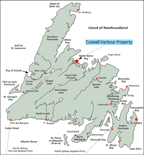
Figure 1. Location of the Cutwell Harbour property.
The Cutwell Harbour property lies outside any parks or other designated lands and no environmental or other encumbrances are known to this author. Bonding requirements for reclamation may be imposed as exploration proceeds.
3
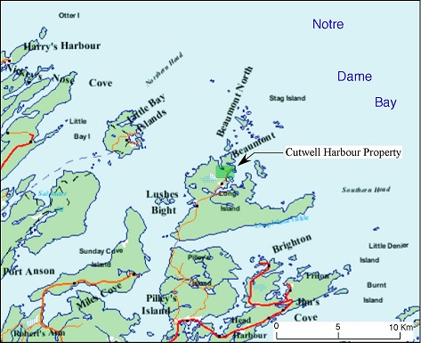
Figure 2. Claim Layout. Cutwell Harbour property shown in green
3. ACCESSIBILITY, CLIMATE, LOCAL RESOURCES, INFRASTRUCTURE AND TOPOGRAPHY
The property is located near the community of Beaumont on Long Island, in Notre Dame Bay, just off the north coast of Newfoundland on NTS map sheet 02E/12. Access to the property can be gained from the Trans-Canada Highway at South Brook via route 380 to Pilley’s island then north via secondary roads and ferry to Long Island and the community of Beaumont.
The region receives abundant snowfall during the winter months, making geological exploration and other related activities impractical during this time. The climate during the remainder of the year is moderate.
4
Car rental services are available in the town of Grand Falls-Windsor, about 120 km southeast of Beaumont on the Trans-Canada Highway. Groceries, fuel and general supplies are available in smaller, nearby communities such as South Brook and Springdale, and access to international air travel is available at Gander, 95 kilometers east of Grand Falls-Windsor.
The topography is moderately rugged with elevations ranging from sea level to about 140 meters. Although some portions of the property are wooded, in general, vegetative and soil cover is sparse, providing good bedrock exposure.
4. HISTORY
In 1864, Alexander Murray noted a spatial association of copper mineralization and volcanic rock sequences in the Notre Dame Bay area. He and J. P. Howley published reports on the regional geology in 1881 and 1918. Princeton University conducted investigations of the regional geology and ore deposits of the area in 1915, 1916 and 1919. Other geologic investigations followed in the 1930’s (MODS report, 4929). Beginning in the 1960’s, studies conducted by Canadian and provincial governmental agencies and universities greatly expanded understanding of the geology of the region.
The first mineral exploration in the area began in the early 1980’s under a joint venture agreement between Brinco Mining Ltd and Getty Mines Limited who conducted reconnaissance exploration that included geological, geochemical and geophysical surveys. This led to the discovery of the Shamrock occurrence, the Gull Cliff and Burnt Head showings on Long Island. Several of these occurrences are hosted in felsic volcanic rocks and in 1983, Getty Canadian Minerals engaged Tillicum Resources Ltd to conduct geologic mapping, sampling and geophysical surveys over other areas of Long Island that are underlain by these rock types. A number of base metal anomalies were identified during this program, and in 1990, northern Long Island was staked under license 3948 issued to Eastern Goldfields. Continued exploration on this claim by Tillicum Resources for Eastern Goldfields led to the discovery of anomalous gold (1072 ppb) at Cutwell Harbour. Eastern Goldfields relinquished these claims in 1993.
5
The extent of recent work on the property is unknown to this author. No exploratory work on the Cutwell Harbour property has been conducted by the current claimant or this author.
5. GEOLOGIC SETTING
5.1 Regional Geology
The region is underlain by Ordovician-Silurian age rocks deposited in a volcanic island arc environment. Lithologies are dominated by felsic to mafic volcanic flows, agglomerates and pyroclastic rocks, but also include fossiliferous limestone, clastic sediments and chert. In this type of dynamic environment, rock units tend to be limited in their aerial extent and lateral continuity, making correlation of units difficult to impossible. Interbedded fossiliferous sedimentary rocks commonly provide the only means by which these rocks can be grouped by age.
On Long Island, volcanic, pyroclastic and sedimentary rocks of the Lower to Middle Ordovician age Cutwell Group comprise a southwest dipping, continuous sequence up to 5 km in thickness. This group was defined by Kean (1973, as cited in Szybinski, 1989) who recognized seven formations and several sequences of related rocks, tentatively included in the group. Figure 3 shows the distribution of these formations as interpreted by Kean and Evans (1994).
Briefly, Kean’s interpretation is as follows: fossiliferous limestone and clastic sedimentary rocks such as shale, chert and argillite, in part, comprise the Long Tickle, Parsons Point, Burnt Head and Pigeon Head formations. Interbedded with these sedimentary rocks, are tuffs, flows, pillow flows and breccias, agglomerates and pyroclastic rocks of basic to intermediate composition.
The Stag Island formation is divided into 3 sub-units; the Basalt member, the Breccia member and Intrusive member. The Basalt member consists of pillow basalts and pillow breccia, deposited in a submarine environment. The Breccia member is a coarse, locally bedded breccia, and the Intrusive member is comprised of diabase and gabbro sills and dikes.
6
Subvolcanic, flow-banded dacite intrusives and related pyroclastic rocks make up the Seal Cove complex, and the Quinton Cove formation consists mainly of coarse agglomerate and minor interbedded tuff and lapilli tuff.
Andesitic flows, pillow lava and pyroclastic rocks of the Burnt Head formation underlie most of the claim block. The Pyroclastic member consists of basic to intermediate agglomerate, lapilli tuff, tuff, minor felsic pyroclastic rocks, argillite, shale and chert. The Pillow Andesite member comprises generally porphyritic andesite flows, pillow lava and pillow breccia, agglomerate and tuff.
Intruding these older rocks are a number of stocks ranging in composition from dacite, to quartz-feldspar porphyry to pink and gray granodiorite. A larger intrusive, the Long Island pluton, is located on the southwest shore of the island. It comprises a complex of breccias of gabbro, diorite and granodiorite and minor aplite.
7
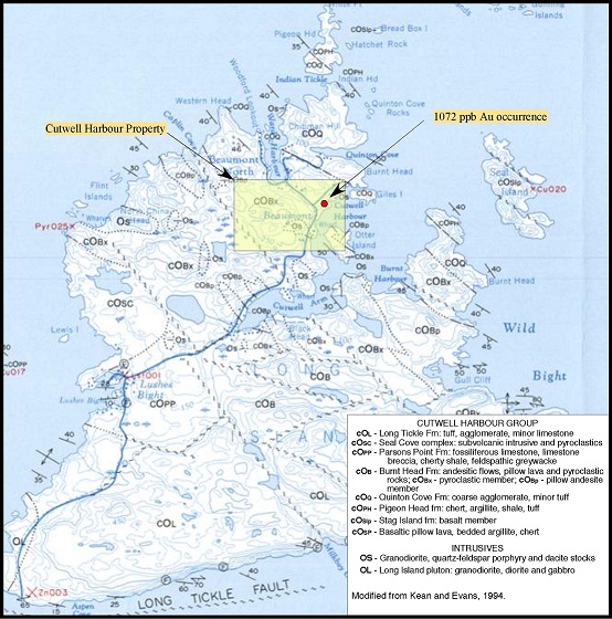
Figure 3. Regional geology.
Although Kean and Evans map was published in 1994, they conducted their field work in 1973, 1982 and 1983. More recent work was carried out by Z. A. Szybinski in 1987 and 1988 and was directed at the structural geology of the region. It revealed a complex history of north-directed thrusting, and it is his interpretation that the stratigraphic succession developed by Kean represents a series of structurally repeated lithologic units.
8
5.2 Property Geology
Kean and Evans (1994) mapped the area underlying most of the property as southwesterly dipping, basic to intermediate pyroclastic agglomerate, tuff and lapilli tuff of the Burnt Head formation. Szybinski (1989) mapped this area as part of his “Tuff Lithofacies” consisting of interbedded tuffaceous turbidites, gray chert and cherty black shale. These lithologies are cut by intercalated horizons of welded to nonwelded dacitic pyroclastic flows containing abundant rip-up clasts of chert and shale.
A small area described as “pink to grey, granodiorite, quartz-feldspar porphyry and dacite dikes” was mapped in the south-central portion of the property by Kean and Evans (1994).
This area is encompassed within a much larger area mapped by Szybinski (1989) as primary volcanic lithofacies. He describe this facies as a diverse mix of basic to felsic lithologies that include dacitic domes and related subvolcanic intrusives, felsic tuffs and tuff-breccia and mafic, basaltic to andesitic, massive and pillowed flows and pillow breccias.
K. B. McHale of Tillicum Resources Ltd conducted reconnaissance geological exploration for Eastern Goldfields Ltd in the vicinity of the Cutwell Harbour property in 1990 that included prospecting, rock chip and stream sediment sampling. His description of the geology generally follows that of Szybinski whom he cites in his report. He reports (1991, pg. 4) that the andesites are blue-green, massive and fine-grained. He further describes the lapilli tuffs as being lithic rich with clasts of andesite, basalt and rhyolite comprising 20-40% of the rock. In addition to these descriptions, he mentions dark gray to black basalts that are strongly magnetic and, in part, amygdaloidal. However, McHale’s maps are very generalized and provide little insight as to the spatial distribution of these diverse lithologies.
6. DEPOSIT TYPE
Undetermined, but possibly epigenetic hydrothermal in origin.
9
7. MINERALIZATION
Gold mineralization is associated with 1-3% coarse, euhedral cubic pyrite and fine-grained disseminated pyrite in a moderately silicified, dark green, fine-grained andesite tuff (table 1, appendix). Sixteen rock chip samples were collected by McHale (1991), two of which had gold values of 225 and 1072 ppb (assay lab report, appendix). These and one other appear to have been collected along strike from the same lithologic unit. The origin of gold mineralization is undetermined, however, silicification of the andesite suggests an epigenetic hydrothermal origin. Some of the pyrite may have been introduced at this time as well, but syngenetic disseminated pyrite should not be unexpected in rocks deposited in a volcanic island arc environment. Kean (1973 as reported in MODS report 4929) and Kean and Evans (1994) have mapped a nearby stock of quartz-feldspar porphyry that may be related to this gold occurrence.
8. EXPLORATION
Neither this author nor the claimant have conducted exploration on or visited the property.
In 1980, Brinco Mining Ltd and Getty Mines Limited formed a joint venture and conducted reconnaissance exploration that included geological, geochemical and geophysical surveys in the vicinity of the Cutwell Harbour property. In response to the discovery of several base metal occurrences in felsic volcanic rocks during this program, Getty Canadian Minerals engaged Tillicum Resources Ltd in 1983 to conduct geologic mapping, sampling and geophysical surveys over other areas of Long Island that are underlain by these rock types. A number of additional base metal anomalies were identified during this program, and in 1990, northern Long Island was staked under license 3948, issued to Eastern Goldfields. Continued exploration on this claim by Tillicum Resources for Eastern Goldfields led to the discovery of anomalous gold (1072 ppb) at Cutwell Harbour. These claims were relinquished by Eastern Goldfields in 1993 and no subsequent exploration in the area is known to this author.
10
9. DRILLING
No drilling known to this author has been undertaken on anomalies covered by the Cutwell Harbour property.
10. SAMPLING
Sixteen samples were collected by Tillicum Resources Ltd in 1991 (table 1, appendix). From the description of the sample locations given by McHale (1991) it appears he sampled old prospect pits in pyritized andesite. All but one of the sample locations were clustered within an area less than 20 by 60 meters in dimension. He also states that all the samples appear to have been collected along strike within a single lithologic unit. He reports that all were analyzed for gold, silver, copper, lead and zinc, but assay lab reports for only eleven of the sixteen were included in his report (assay lab report, appendix). Two of these yielded anomalous values of 225 ppb and 1072 ppb Au. The remaining yielded values ranging from 11 ppb to 46 ppb Au. None of the samples returned silver values greater than 0.8 ppm. Lead and zinc values were 75 ppm and 119 ppm or less, respectively. Copper values were not significantly elevated, the highest being 259 ppm.
According to McHale’s description and map, the 1072 ppb Au sample was collected over a 10 meter interval. Interpreting this isn’t easy as his descriptions of sample sites are generalized. One possibility is that this grade is uniformly distributed over the entire 10 meters. This would suggest more or less uniformly disseminated mineralization throughout the host rock. Since other, nearby samples did not return similar results, this seems unlikely. More likely; most of the host rock is relatively barren, but a portion of a high-grade vein was included in the sample which spiked the average value.
11. ADJACENT PROPERTIES
The closest claims to the Cutwell Harbour group are located 1.5 km to the south. These claims are held by an equipment rental company from Triton, NL. Another group, 3 km distant are held by an individual from Grand Falls-Windsor, NL. It is unknown to this author if any exploration activities have been conducted on these properties.
11
12. INTERPRETATION AND CONCLUSIONS
Most rock chip sampling conducted by Tillicum Resources was concentrated within an area less that 20 by 60 meters in dimension with the exception of one sample collected about 100 meters along strike on the mineralized unit. An anomalous gold value of 1072 ppb was returned for one of the clustered samples and a value of 225 ppb for the sample collected 100 meters distant. The 1072 ppb sample is notable as it was not collected from a single site, but over a 10 meter interval. The elevated values indicate potential for economic grades of gold mineralization over significant portions of this unit. Widespread silicification and pyritization coupled with the proximity of a possible source of mineralization in the form of the nearby felsic stock lend further support to this potential.
The clustering of samples taken to date has not delineated the aerial extent nor defined the nature of mineralization. It is known that the region has been subjected to extensive structural deformation so the possibility of vein or stockwork mineralization exists here.
Armed with our present understanding of this gold occurrence, the potential for economic mineralization could be evaluated relatively easily through a mapping and sampling program.
13. RECOMMENDATIONS
The locations where McHale collected his samples should be visited and a detailed description of the host rock, the mineralization and any other notable characteristics, such as veins, mineralized fractures, etc. should be made. Using this information, the unit should be traced along strike and mapped as well as outcrop exposure will allow. Sampling density should adequately represent as much of the unit as possible.
12
13.1 Budget
A budget for the proposed work program is as follows (in US$):
|
Phase I
|
||
|
1. Preparation for field, travel & lodging arrangements, base map preparation
|
$ | 700 |
|
(1 day office @ $700/day)
|
||
|
2. On site surface reconnaissance, mapping, sampling
|
$ | 4,900 |
|
(5 days field, 2 days travel @ $700/day)
|
||
|
3. Geochemical analyses (≈30 samples)
|
$ | 900 |
|
(Sample prep + Au & Ag fire assay AA finish @ $30/ sample)
|
||
|
4. Expenses:
|
||
|
Round trip air fare Reno, NV- Gander, NL
|
$ | 1,200 |
|
Truck rental, 6 days
|
$ | 600 |
|
Vehicle fuel
|
$ | 150 |
|
Lodging, 6 nights @ $85/night
|
$ | 510 |
|
Meals, 6 days @ $45/day
|
$ | 270 |
|
Contingency (15%)
|
$ | 1,384 |
|
Total Phase I:
|
$ | 10,614 |
|
Phase II
|
||
|
1. On site mapping and sampling
|
$ | 7,000 |
|
(8 days field, 2 days travel geologist @ $700/day )
|
||
|
2. Geochemical analyses (≈50 samples)
|
$ | 1,500 |
|
(Sample prep + Au & Ag fire assay AA finish @ $30/ sample)
|
||
|
3. Data compilation and report preparation
|
$ | 2,800 |
|
(4 days office @ $700/day)
|
||
|
4. Expenses:
|
||
|
Round trip air fare Reno, NV- Gander, NL
|
$ | 1,200 |
|
Truck rental, 8 days
|
$ | 520 |
|
ATV rental, 8 days
|
$ | 400 |
|
Vehicle fuel
|
$ | 200 |
|
Lodging, 8 nights @ $85/night
|
$ | 680 |
|
Meals, 8 days @ $45/day
|
$ | 280 |
|
Contingency (15%)
|
$ | 2,187 |
|
Total Phase II:
|
$ | 16,767 |
| Grand Total Exploration: | $ | 27,381 |
13
14. REFERENCES CITED
Kean, B. F. and Evans, D.
1994: Geology and Mineral occurrences of the Little Bay Islands map area. Newfoundland and Labrador, Mineral Development Division, Map No. 94-228 [GSB# 002E/12/0926]
McHale, K B
1991: First year assessment report on geological and geochemical
exploration for licence 3948 on claim block 4342 in the Cutwell Harbour and North China Head areas on Long Island in Notre Dame Bay, Newfoundland.
Eastern Goldfields Limited Unpublished report, 58 pages. [GSB#
002E/12/0793]
MODS Report, Cutwell Harbour, Record ID Number 4929, Department of Natural Resources, Government of Newfoundland and Labrador, Canada.
Szybinski, Z A
1989: Geology of the Cutwell Group, Notre Dame Bay, Newfoundland: a
disrupted volcanic-volcaniclastic island-arc complex. In Current Research.
Geological Survey of Newfoundland, Department of Mines, Government of
Newfoundland and Labrador Report 89-01, pages 141-147. [GSB# NFLD/1778]
14
APPENDIX
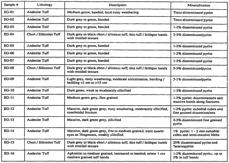
Table 1. Sample descriptions (McHale, 1991, table 4-1)
15
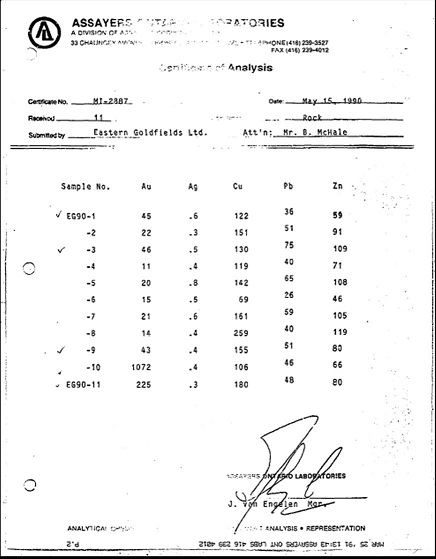
Assay Lab Report (McHale, 1991)
15. STATEMENT OF QUALIFICATIONS
I, Richard A. Jeanne, owner of Richard A. Jeanne, LTD, with a business address at 3055 Natalie Street, Reno Nevada, 89509, USA, do hereby certify that:
|
1.
|
I hold a Bachelor of Science degree in Geology from Northern Arizona University and a Master of Arts degree in Geology from Boston University with over 30 years experience in the field of geology since graduation;
|
|
2.
|
I am registered with the American Institute of Professional Geologists as a Certified Professional Geologist (Certificate Number 08397);
|
|
3.
|
I am a Consulting Geologist specializing in base and precious metals and minerals exploration, mining geology and property evaluation;
|
|
4.
|
This report is based on information obtained by me from the Online Mineral Claims Staking System web site and other internet sources;
|
|
5.
|
I am independent of QUEENSRIDGE MINING RESOURCES LTD and of any affiliate thereof; I hold no interests, direct or indirect, in the properties or securities of QUEENSRIDGE MINING RESOURCES LTD or any of its affiliates, nor do I expect to receive any; QUEENSRIDGE MINING RESOURCES LTD is not a publicly traded company at this time;
|
|
6.
|
I hereby give my permission to include this report in any document to be filed with any appropriate regulatory agency.
|
Dated and signed at Reno, Nevada this 30th day of March, 2010.
/s/ Richard A. Jeanne
Richard A. Jeanne
Consulting Geologist